Dovrefjell - a National Symbol
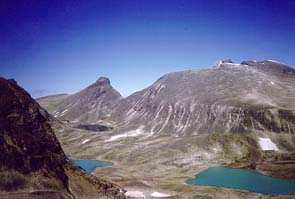
Photo: Per Roger Lauritzen, DNT
The western parts of the park contain precipitous and wild mountains. Towering above them all is Snøhetta, which reaches 2286 meters above sea level. The east has calcareous bedrock, and here we find northern Europe's richest mountain in terms of
plant life with such plants as the Norwegian wormwood, the mountain avens and a poppy particular to Dovre. The park has a rich bird life. Fokstumyra Nature Reserve - one of the best known bird wetlands in Norway - is situated next to a main highway a
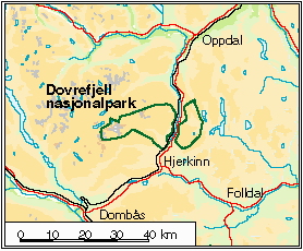
prox. 20 kilometers south of the park. The highway and a railroad traverses the area.
In 1993 the Norwegian authorities cancelled their plans for the creation of an underground dump site for hazardous waste,
close to the National Park.
Area : 256 km2
Protected : 1974
Source: DN: Directorate for nature management.
Map : SKMe: Norwegian Mapping Authority - Environmental Unit.