| CES Technical Report 131, August 2013 |
|
Ecological Modelling and Energy DSS
|
|
Predictive distribution modeling for rare Himalayan medicinal plant Berberis aristata DC.
|
|
Abstract –
Predictive distribution modelling of Berberis aristata DC a rare, threatened plant with high medicinal values has been done with an aim to understand its potential distribution zones in Indian Himalaya Region. Bioclimatic and topographic variables were used to develop the distribution model with the help of three different algorithms viz. Genetic Algorithm for Rule-set Production (GARP), Bioclim and Maximum Entropy (MaxEnt). MaxEnt has predicted wider potential distribution (10.36%) compared to GARP (4.63%) and Bioclim (2.44%). Validation confirms that these outputs are comparable to the present distribution pattern of the B. aristata. This exercise highlights that this species favours western Himalaya. However GARP and MaxEnt’s prediction of eastern Himalayan states (i.e. Arunachal Pradesh, Nagaland and Manipur) are also identified as potential occurrence places require further exploration.
Keywords: Berberis aristata, Bioclim, Distribution modeling, GARP, Indian Himalayan Region, MaxEnt
Introduction-
The Indian Himalayan Region (IHR) harbours a wide spectrum of biodiversity which is reflected in diverse groups of flora, fauna and microorganisms. It supports about 8000 species of angiosperms of which 40% are endemics and the region is aptly considered as “hotspot” of Indian flora as well as part of the recently announced Himalaya “hotspot” (Nayar, 1996; Conservation International, 2007). The presence of rich biodiversity is mainly attributed to diverse habitat types influenced by wide altitudinal range (300 – 8000 m), varied rainfall and precipitation, temperature regime and complex topographical features (Samant et al., 1998).
The vast number of medicinal plants present in the region is an integral part of the livelihood of local communities. Apart from their medicinal usage, many plants are used as edible items, source for oil, fodder, fuel and timber which has been documented for a long time (Singh et al., 1984; Olsen and Larsen, 2003). However, the exponential increment of natural resource utilization, booming market demand and environmental changes nowadays put the medicinal plant resources under serious threat of existence (Ved et al., 2003). The growing list of rare, threatened and endangered plants of the region is a direct outcome of these consequences.
The raising awareness towards the importance of Himalayan biodiversity and alarming rate at which they are being exploited from natural habitats leads to initiate various conservation actions to mitigate such uncontrolled resource exploitation and its management (Arunachalam et al., 2004; Rana and Samant, 2010). As a part of the conservation and management programme, species distribution and its ecological characteristic features must be taken into consideration for species protection / restoration activities (Hirzel et al., 2004; Sanchez-Cordero et al., 2005; Martinez-Meyer et al., 2006). Himalayan region requires special attention in this regard, as frequent environmental changes take place because of its mountainous nature. The enormous variation in the altitude, latitude and longitude of the Himalayas has added to the multiplicity of habitats and provides diverse microclimates and ecological niches for all the living beings (Karan, 1989; Carpenter, 2005; Anonymous, 2006). Although information on plant distribution and their environmental association in IHR are available to some extent, there is a gap in understanding species ecological amplitude and its application in systematic management of resources.
Berberis aristata, a well known medicinal plant in IHR and its occurrence is reported from middle altitude areas (1800-3000 m) of the state of Uttarakhand and Himachal Pradesh (Samant et al., 1998; Chauhan, 1999). It is a spinescent shrub, 3-6 m in height with obovate to elliptic, toothed leaves, yellow flowers in corymbose racemes and oblong-ovoid, bright red berries. The extract from root-barks, roots and lower stem-wood, (known as Rasanjana or Rasaut or Rasavanti) is used as stomachic, laxative, hepato-protective, antipyretic and in other ailments (Wang et al., 2004; Shahid et al., 2009; Semwal et al., 2010). It is useful in eye diseases particularly in conjunctivitis, indolent ulcers and in hemorrhoids (Rashmi et al., 2008). The plant is mostly collected from wild areas, and its agro-technique, cultivation is poorly known. Therefore, high demand for local usage as well as for pharmaceuticals creates a serious pressure on the natural resource which already categorized the plant as endangered (Srivastava et al., 2006; Ali et al., 2008). As a remedial measure, exploration of new resource, conservation of the existing resources and establishment of cultivation are of prime importance for what systematic planning and management is essential and where distribution modeling can play a key role.
Predictive distribution models aid in forecasting the spatial occurrence of species, especially, habitat suitability or realized niche based on the data from traditional field work in conjunction with climatic and topographic factors (such as slope, elevation, and precipitation) (Pearson, 2007). This habitat suitability or niche prediction is done through various algorithms or principles which usually integrate the species occurrence information and environmental data to find out the possible favourable places. A number of algorithms are available nowadays for performing the task and each unique to their data requirement, statistical methods and ease of use.
We selected Genetic Algorithm for Rule-set Production (GARP), Bioclim and Maximum Entropy (MaxEnt) methods for our study because of their predictive abilities and wide usage.
Precise prediction of the distribution of endemic and endangered species is useful for decision makers, especially for those whose conservation and management activities involve large areas but constrained by resources to carry out detail exploration / investigation. Potential distribution of species prioritises the favourable biogeographic areas to lead the conservation / management activity in a more focused way. The advantages of distribution modeling is manifold like, explaining basic ecological phenomenon behind species distribution, understanding biogeography and dispersal barriers, verification of the earlier presence records, explored the yet uncovered regions, assessment of impacts of environmental changes over species distribution, conservation planning and reserve system design (Peterson, 2006; Guisan and Thuiller, 2005; Johnson, 2005). Considering the extent of plant distribution and diversity in India, available data related to ecology and environmental preference still represents a small fraction of this vast field especially distribution modelling (Ganeshaiah et al., 2003; Irfan Ullah et al., 2007; Giriraj et al., 2008).
In our study, we developed predictive distribution models of Berberis aristata using three different modeling techniques, GARP, Bioclim and MaxEnt to know its potential distribution in Indo-Himalayan region.
Materials and Methods –
Study area
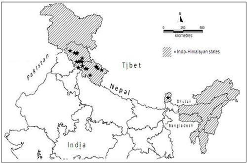
Indian Himalayan Region (IHR) ranges from Jammu & Kashmir to Arunachal Pradesh including Himachal Pradesh, Uttarakhand, Sikkim, Darjeeling district of West Bengal. North East states (i.e. Assam, Meghalaya, Manipur, Nagaland, Mizoram and Tripura) are also included as part of eastern Himalaya as per available literature (Samant et al., 1998; WWF-US, 2005) (Fig 1.).
Figure 1: Study area : Indo – Himalayan Region (= occurrence points for B.aristata)
Species occurrence data
Twenty one occurrence points of Berberis aristata were shortlisted from a collection of field survey done at Moolbari watershed area of Himachal Pradesh, India and secondary data available from published literatures (Uniyal, 2002; Chhetri et al., 2005 and Anonymous, 2007-2008) (Fig 1.). Moolbari watershed is situated in Shimla district, Himachal Pradesh, India and encompasses an area of 13.41 sq. km from 31.07-31.170 N and 77.05-77.150 E. Field study was conducted by following standard ecological methods and the species was identified with the help of keys (published flora) in addition to the consultation of herbarium samples and discussion with the Himalayan flora experts.
Environmental data
For environmental information, 19 bioclimatic variables derived from globally interpolated datasets (source: http://www.worldclim.org) representing annual trends, seasonality and extreme or limiting environmental factors, were used for the modelling study which are presumed to be maximum relevant to plant existence (Pearson and Dawson, 2003; Irfan Ullah et al., 2007). The WorldClim climate layers were created by interpolating observed climate from climate stations around the world, using a thin-plate smoothing spline set to a resolution of approximately 1 km, over the 50-year period from 1950 to 2000 (Hijmans et al., 2005). Additioinally, we used aspect, slope, altitude (http://edc.usgs.gov/products/elevation/gtopo30/hydro/asia.html and http://www.worldclim.org) and landcover (GLC 2000), in the model development (Table1). All analyses were conducted at the 1 x 1 km pixels spatial resolution of the environmental data sets since, bioclimatic variables with finer than 1 km resolution is not available at this moment. All environmental data layers were finally cropped for the study area (Indian Himalayan Region) to perform the modeling experiment.
Model development-
We followed three different modeling techniques for our study. The open Modeller desktop version 1.0.9 was used for GARP (GARP with best subsets – Desktop GARP implementation) and Bioclim techniques. Maxent 3.3.1 used for performing Maxent algorithm (downloaded from http://www.cs.princeton.edu/~schapire/maxent/). A brief description of the techniques is mentioned below.
GARP is a genetic algorithm that creates ecological niche models for species. The models describe environmental conditions under which the species should be able to maintain populations. For input, GARP uses a set of point localities where the species is known to occur and a set of geographic layers representing the environmental parameters that might limit the species' capabilities to survive. Details of the modeling algorithm can be found in Stockwell and Peters, 1999. In our study, we assigned 50% of the occurrence points as training data for developing the model while rest of the data has been used as intrinsic test data. For other parameters, we used default values available in open Modeler i.e. commission threshold = 50% of distribution models, omission threshold = 20% of the models with least omission error and resample value = 2,500.
Bioclim is one of the earlier modeling techniques, tallying species occurrence points for each environmental variable including 95% of the distribution (i.e. excluding extreme 5% of the distribution) along each ecological dimension. Details of the algorithm can be obtained from Busby (1991).
Table 1. Environmental Variables used in the model development
Variables |
Details |
BIO1
BIO2
BIO3
BIO4
BIO5
BIO6
BIO7
BIO8
BIO9
BIO10
BIO11
BIO12
BIO13
BIO14
BIO15
BIO16
BIO17
BIO18
BIO19
Slope
Aspect
Altitude
Landcover |
Annual mean temperature
Mean diurnal temperature range [mean of monthly (max temp–min temp)]
Isothermality (P2/P7) (×100)
Temperature seasonality (standard deviation×100)
Max temperature of warmest month
Min temperature of coldest month
Temperature annual range (P5–P6)
Mean temperature of wettest quarter
Mean temperature of driest quarter
Mean temperature of warmest quarter
Mean temperature of coldest quarter
Annual precipitation
Precipitation of wettest month
Precipitation of driest month
Precipitation seasonality (coefficient of variation)
Precipitation of wettest quarter
Precipitation of driest quarter
Precipitation of warmest quarter
Precipitation of coldest quarter
Slope value from digital elevation model (http://edc.usgs.gov)
Aspect value from digital elevation model (http://edc.usgs.gov)
Elevation above sea level (m)
Global landcover map |
The maximum entropy (MaxEnt) approach estimates a species' environmental niche by finding a probability distribution that is based on a distribution of maximum entropy (with reference to a set of environmental variables) (Phillips et al., 2006). Default values of different parameters, maximum iterations = 500, convergence threshold = 0.00001 and 50% of data points were used as random test percentage in our study.
Model validation -
Prediction accuracy of all three model outputs was measured through receiver operating characteristics (ROC) analysis because of its wider application in the modeling studies despite some recent arguments (Lobo et al., 2008; Boubli and Lima, 2009; VanDerWal et al., 2009; Yates et al., 2010). ROC plot can be generated by putting the sensitivity values, the true positive fraction against the false positive fraction for all available probability thresholds. A curve which maximizes sensitivity against low false positive fraction values is considered as good model and is quantified by calculating the area under the curve (AUC). An AUC statistic closer to1.0 indicates total agreement between the model and test data and considered as good model. An AUC with value closer to 0.5 considered to be no better than random.
Result and Discussion –
Predictions of the potential distribution of Berberis aristata in Indo-Himalayan region are comparable based on its current distribution in the region. Model outputs are varied according to the modeling techniques (Fig 2 A, B and C).
Fig 2. Modelling outputs from three different algorithms
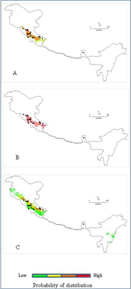
A = GARP, B = Bioclim, C = MaxEnt
Both the GARP and MaxEnt models show distribution spread in western and eastern Himalayan states of India. On the contrary, Bioclim output is restricted in western Himalayan region i.e., Himachal Pradesh and Uttarakhand. . All three models show higher accuracy and AUC value near 1.0 with low omission error (Table 2).
Table 2. Comparative details of the modeling outputs
| Parameters |
Modelling techniques |
| GARP |
Bioclim |
Maxent |
| Accuracy |
86.66 |
100 |
- |
| AUC value |
1.0 |
1.0 |
0.969 (training set)
0.947 (test set) |
| Omission error |
0.142 |
0 |
- |
| Total distribution (% of total area) |
4.63 |
2.44 |
10.36 |
| High probability area (% of total distribution) |
29.65 |
100 |
6.27 |
Modelling outputs reveal that, MaxEnt has predicted largest area (10.36% of Indo-Himalayan region) under potential distribution in comparison to GARP (4.63%) and Bioclim (2.44%). However, Bioclim has higher high probability regions (100%) than GARP and MaxEnt (i.e. 29.65% and 6.27% respectively). Both GARP and MaxEnt have shown a wider range of distribution from low to high probability in Himachal Pradesh, Uttarakhand, Jammu-Kashmir, Arunachal Pradesh, Nagaland and Manipur whereas, Bioclim distribution is restricted as high probability areas in Himachal Pradesh and Uttarakhand.
The jackknife test of variable importance in MaxEnt has identified the precipitation of driest quarter (bioclimatic variable 17) as the most important environmental variable in model development. This variable has highest predictive value or gain when used in isolation. Other variables like precipitation of coldest quarter (bioclimatic variable 19), temperature seasonality (bioclimatic variable 4), mean temperature of coldest quarter (bioclimatic variable 11) and minimum temperature of coldest month (bioclimatic variable 6) also have considerable predictive value with regard to distribution of Berberis aristata.
Potential distribution maps show various possibilities for conservation and management of this valuable plant species. Clustering of high probability areas in the North-western states around the occurrence points indicate the suitability of the region for further exploration as well as reintroduction / conservation program as it satisfies fundamental niche requirement of the species. Considering the mountainous inhospitable nature of the Himalayan region, targeting high probability regions for future exploration could increase the probability of success in the venture. Earlier endevours involving field surveys / exploration based on model outputs had helped in discovering new populations as well as allied species (Raxworthy et al., 2003; Siqueira et al., 2009). This prior information on species probable distribution in the area certainly helps in judicious utilization of resources and time. On the other hand, new areas like eastern Himalayan states have come out as potential occurrence sites for the species as evidenced through GARP and MaxEnt outputs. At present we have only one occurrence record from this site (i.e. Sikkim) but further studies may improve the candidature of the region as favorable site for the Berberis aristata. This idea gets support from available literature on Berberis spp. distribution in India, where several other species of Berberis viz,, B. asiatica var asiatica, B. parisepala, B. macrosepala var macrosepala, B. insignis, B. dasyclada etc. have been reported from north eastern Himalayan states (Sharma et al., 1993). The presence of other species in the region may open up the possibilities for B. aristata as several studies have indicated niche conservatism among the closely related species (Peterson, 1999). However, this could only be verified after field exploration and collection of information.
This exercise could be useful for comparing natural resource distribution pattern and conservation / management strategies to protect them. Application of species distribution modeling in conservation area planning and management is widely used nowadays (Araujo and Williams, 2000; Ortega-Huerta and Peterson, 2004; Pearson, 2007). By knowing the potential distribution region, especially the high probability areas (here it is part of Uttarakhand and Himachal Pradesh), it is possible to design conservation priority zone / resource management zone with an emphasis on species ecological boundary. This approach from ecological viewpoint makes species survival and management easier and more efficient than other practices.
Acknowledgement
We are grateful to the Ministry of Science and Technology, Government of India and Indian Institute of Science for the financial assistance. We thank Mr. G.R. Rao, Vishnu Mukri and Dr. Archana Singh (NBPGR, Shimla, Himachal Pradesh) for suggestions during the field investigations. Special thanks to Mr. Uttam Kumar and Mr. Bharath Setturu for their help in GIS analysis.
Reference
- Ali M, A.R. Malik,and K.R. Sharma : Vegetative propagation of Berberis aristata DC. An endangered Himalayan shrub. J. Med. Pl. Res. 12, 374-377 (2008).
- Anonymous: Forest Research Institute (FRI), Dehradun, India. (2007-2008).
- Anonymous: THE MOUNTAIN ECOSYSTEMS [Environment and Forest Sector] for Eleventh Five Year Plan. Report. Planning Commission, Government of India, November 2006
- Araújo M.B. and P.H. Williams: Selecting areas for species persistence using occurrence data. Biol. Conserv. 96, 331-345 (2000)
- Arunachalam, A,, R. Sarmah, D. Adhikari,M. Majumder and M.L. Khan:Anthropogenic threats and biodiversity conservation in Namdapha nature reserve in the Indian Eastern Himalayas. Curr. Sci, 87, 447-454 ( 2004)
- Boubli, J.P.and M.G. de Lima, : Modeling the Geographical Distribution and Fundamental Niches of Cacajao spp. and Chiropotes israelita in Northwestern Amazonia via a Maximum Entropy Algorithm. Int. J. Primatol. 30,217–228 (2009)
- Busby, J.R: BIOCLIM - a bioclimate analysis and prediction system. In: Nature conservation: cost effective biological surveys and data analysis (Eds.: C.R. Margules and M.P. Austin). CSIRO, pp. 64-68 (1991).
- Carpenter, C.: The environmental control of plant species density on a Himalayan elevation gradient. J. Biogeogr. 32, 999–1018 (2005)
- Chauhan, N.S.: Medicinal and Aromatic plants of Himachal Pradesh. Indus Publishing Company, New Delhi. Pp.114-117 (1999).
- Chhetri D.R., P. Parajuli, and G.C. Subba : Antidiabetic plants used by Sikkim and Darjeeling Himalayan tribes, Ind. J. Ethnopharmacol., 99, 199–202 (2005).
- Conservation International: Biodiversity Hotspots (2007). Website: http://www.biodiversityhotspots.org
- Ganeshaiah, K.N., N. Barve, N. Nath, K. Chandrashekara, M. Swamyand R. Uma Shaanker. : Predicting the potential geographical distribution of the sugarcane woolly aphid using GARP and DIVA-GIS. Curr. Sci., 85, 1526-1528 (2003).
- Giriraj, A., M. Irfan-Ullah, B.R. Ramesh, P.V. Karunakaran, A. Jentsch, and M.S.R. Murthy: Mapping the potential distribution of Rhododendron arboreum Sm. ssp. Nilagiricum (Zenker) Tagg (Ericaceae), an endemic plant using ecological niche modelling. Curr. Sci., 94, 1605-1612 (2008).
- Global Land Cover 2000 (GLC 2000) database. European Commission, Joint Research Centre, (2003). http://gem.jrc.ec.europa.eu/products/glc2000/glc2000.php
- Guisan, A, and W. Thuiller: Predicting species distribution: offering more than simple habitat models. Ecol. Lett. 8, 993-1009 (2005)
- Hijmans, R. J., S. Cameron, J. Parra, P. Jones and A. Jarvis: Very high resolution interpolated climate surfaces for global land areas. Int. J. Clim. 25,1965–1978 (2005).
- Hirzel, A.H., B. Posse, P. Oggier, Y. Crettenand, C. Glenz, R. Arlettaz: Ecological requirements of reintroduced species and the implications for release policy: the case of the bearded vulture. J. Appl. Ecol 41, 1103–1116 (2004)
- Irfan-Ullah M., A. Giriraj, M.S.R Murthy and A.T. Peterson: Mapping the geographic distribution of Aglaia bourdillonii Gamble (Meliaceae), an endemic and threatened plant, using ecological niche modelling. Biodivers. Conserv., 16, 1917–1925 (2007).
- Johnson, C.J. and M.P. Gillingham: An evaluation of mapped species distribution models used for conservation planning. Environ Conserv., 32, 117-128 (2005)
- Karan, P.P.: Environment and Development in Sikkim Himalaya: A Review. Hum. Ecol. 17, 257-271 (1989)
- Lobo, J.M., A. Jime´nez-Valverde and R. Real: AUC: a misleading measure of the performance of predictive distribution models. Glob Ecol Biogeogr., 17,145–151 (2008)
- Martínez-Meyer, E., A.T. Peterson, J.I. Servín and L.F. Kiff: Ecological niche modelling and prioritizing areas for species reintroductions. Oryx, 40, 411-418 (2006)
- Nayar, M.P: “Hot spots” of endemic plants of India, Nepal and Bhutan. Tropical Botanic Garden and Research Institute. Palode, Thiruvananthapuram, Kerala, India, pp. 252 (1996).
- Olsen, C.S. and H.O. Larsen: Alpine medicinal plant trade and Himalayan mountain livelihood strategies. Geo. J., 169, 243-254 (2003).
- Ortega-Huerta, M.A. and A.T.Peterson: Modelling spatial patterns of biodiversity for conservation prioritization in North-eastern Mexico. Divers Distrib.,10, 39-54 (2004)
- Pearson, R.G. and T.P. Dawson: Predicting the impacts of climate change on the distribution of species: are bioclimatic envelope models useful? Global. Ecol.Biogeogr., 12, 361-371(2003).
- Pearson, R.G: Species distribution modelling for conservation educators and practitioners. Synthesis. American Museum of Natural History (2007). Available at http://ncep.amnh.org
- Peterson, A.T., J. Soberon and V.S. Cordero: Conservatism of ecological niches in evolutionary time. Science, 285, 1265-1267 (1999).
- Peterson, A.T: Uses and requirements of ecological niche models and related distributional models. Biodivers. Info., 3, 59 – 72 (2006).
- Phillips, S.J, M. Dudik and R.E. Schapire: A maximum entropy approach to species distribution modeling. In Proceedings of the 21st international conference on machine learning, pp. 655-662 (2004). AMC Press, New York.
- Phillips, S.J., R.P. Anderson and R.E. Schapire: Maximum entropy modeling of species geographic distributions. Ecol. Model. 190, 231- 259.(2006)
- Rana, M.S. and S.S. Samant: Threat categorisation and conservation prioritisation of floristic diversity in the Indian Himalayan region: A state of art approach from Manali Wildlife Sanctuary. J. Nat. Conserv., 18, 159-168 (2010)
- Rashmi, A. Rajasekaran and J. Pant: The genus Berberis Linn.: A Review. Phcog Rev, 2, 369-385 (2008).
- Raxworthy, C.J., E. Martinez-Meyer, N. Horning, R.A. Nussbaum, G.E. Schneider, M. A. Ortega-Huerta and A.T. Peterson: Predicting distributions of known and unknown reptile species in Madagascar. Nature 426, 837-841 (2003)
- Samant. S.S, U. Dhar and L.M.S. Palni: Medicinal plants of Indian Himalaya: diversity, distribution potential values. Gyanodaya Prakashan, Nainital, India, pp.163 (1998).
- Sánchez-Cordero, V., V. Cirelli, M. Munguía and S. Sarkar: Place prioritization for biodiversity representation using species’ ecological niche modeling. Biodivers. Inf., 2, 11-23 (2005)
- Semwal, B.C., J. Gupta, S. Singh, Y. Kumar and M. Giri: Antihyperglycemic activity of root of Berberis aristata DC. in alloxan-induced diabetic rats. International Journal of green Pharmacy DOI: 10.4103/0973-8258.56288
- Shahid, M., T. Rahim, A. Shahzad, T.A. Latif, T. Fatma, M. Rashid, A. Raza and S. Mustafa: Ethnobotanical studies on Berberis aristata DC. root extracts. African J. Biotechnol. 8, 556–563, (2009)
- Sharma, B.D., N.P. Balakrishnan, R.R. Rao and P.K. Hajra (eds.): Flora of India. Botanical Survey of India, Kolkata, India. 1, 351-405 (1993).
- Singh J.S., U. Pandey and A.K. Tiwari : Man and forests: A central Himalayan case study. Ambio, 13, 80-87 (1984).
- Siqueira, M.F., G. Durigan, P.M. Ju´nior and A.T. Peterson: Something from nothing: Using landscape similarity and ecological niche modeling to find rare plant species. J. Nat. Conserv., 17 , 25—32 (2009)
- Srivastava, S.K, V. Rai, M. Srivastava, A.K.S. Rawat and S. Mehrotra: Estimation of heavy metals in different Berberis species and its market samples. Environ. Monit. Assess., 116, 315–320 (2006)
- Stockwell D. R. B. and D. Peters: The GARP modeling system: Problems and solutions to automated spatial prediction. Int. J. Geogr. Inf. Sci., 13, 143–158 (1999).
- Uniyal V.P: Nanda Devi Expedition (Report). Wildlife Institute of India, Dehradun (2002)
- VanDerWal, J., L.P. Shoo, C. Graham and S.E. Williams: Selecting pseudo-absence data for presence-only distribution modeling: How far should you stray from what you know? Ecol. Model., 220, 589–594, (2009)
- Ved D.K., G.A. Kinhal , K. Ravikumar , V. Prabhakaran , U. Ghate, R. Vijaya Sankar and J.H. Indresha (eds.) : Conservation Assessment and Management Prioritisation for the medicinal plants of Himachal Pradesh, Jammu & Kashmir and Uttaranchal. Foundation for Revitalisation of Local health Traditions (FRLHT), Bangalore, India (2003).
- Wang, F., H.Y. Zhou, G. Zhao, L. Fu, L. Cheng, J. Chen and W. Yao: Inhibitory effects of berberine on ion channels of rat hepatocytes. World. J. Gastroenterol., 10, 2842-2845 (2004)
- WWF-US, Asia Program: Ecosystem Profile: Eastern Himalayas Region. Website: www.cepf.net/Documents/final.ehimalayas.ep.pdf (2005).
- Yates, C.J., A. McNeill, J. Elith and G.F. Midgley: Assessing the impacts of climate change and land transformation on Banksia in the South West Australian Floristic Region. Diversity Distrib., 16, 187–201(2010)
BACK « TOP » NEXT
|