 |
Landslides at Karwar, October 2009 : Causes and Remedial Measures |
 |
SECTION 5 : Worldwide statistics shows that 89.2% of landslide deaths were due to slope failures triggered by intense and prolonged precipitation. The rest were due to construction leading to undercutting of slopes, mining and quarrying, earthquakes etc. Rainfall of course is mainly the final factor to act upon slopes destined to fail, the causes for which are physico-chemical properties of the rock mass, topography relief, slope, aspect, geological structure, land use land cover, vegetation cover, anthropogenic causes etc. Peak occurrence of landslides in South Asia in July suggests their strong linkages with Asian monsoon (South Asian Disaster Report,2007). The Himalayas are the worst affected by landslides in the country, followed by the North-Eastern States and the Western Ghats. Rainfall triggered most of the major landslides that occurred in India during 2009 (up to early November) as the Table 5.1 based on details provided by Geological Survey of India shows. It may not be single slope failure in each locality shown. Associated with heavy rainfall, often, a series of landslides have taken place. Most landslides are in the Himalayas; the Uttarakhand region leading in rainfall triggered slope failures. The latest to happen after the Kadwad village tragedy in Karwar is that in Ooty region of Nilgiris during early November, 2009, which claimed 43 human lives. Widespread destruction of houses, crops and other property, disruption of road and rail traffic and communication systems compound to the miseries caused by floods in the same regions. In the higher altitudes of Himalayas heavy snowfall also causes landslides as in Jammu and Kashmir and Himachal Pradesh. Rain threshold
Table 5.1: Notable landslide occurrences in India during July to early November, 2009,
(as reported by the Geological Survey of India, Government of India).
Rainfall factor in Karwar According to a report in Geo Karnataka (October 19, 2009), at around 4.15 pm the eastern scarp flank of Zariwada hamlet in Kadwad village “suddenly gave up and ruptured with a thud sound. The massive quantity of loose clayey material abruptly rolled down the gradient and settled on the 9 houses burying the 19 inmates alive. The whole process ended by 4.30 pm.” “On 3-10-2009, early morning around 3.30 am, another clayey hill on the western side of Zariwada also collapsed blocking the road leading to Kadwada. However there were no human casualties since the houses were located at a distance from the affected hills. It is reported that similar landslides had occurred in the Kadwada area, during the year 1959.” The rainfall data collected from Dy. Commissioner’s office, Uttar Kannada Dist., Karwar for 1st September 2009 to 13th October 2009, as recorded at Karwar rain gauge station is given in Table 5.2. The analysis of antecedent and precedent rainfall pattern indicate an unprecedented rise in the quantum of rainfall from 30th September 2009 to 4th October 2009. As per the information from the local authorities, all the landslides occurred on 2nd October 2009 even though the maximum daily rainfall received was on 3rd Oct 2009 which is nearly 2.5 times more than the rainfall received on previous day. The immediate trigger for all the slides is observed to be the high rainfall. Heavy rainfall: a matter of grave concern
Table 5.2: Rainfall during Sept-Oct 2009
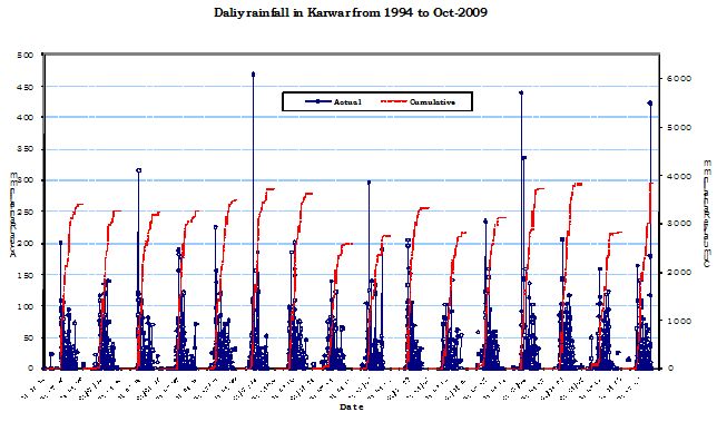
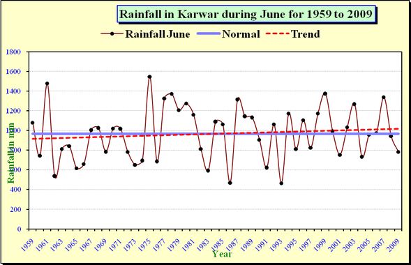
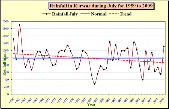
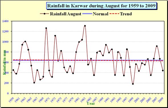
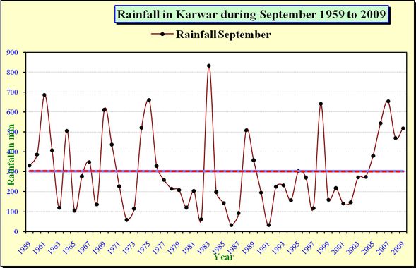
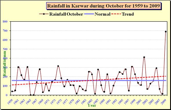
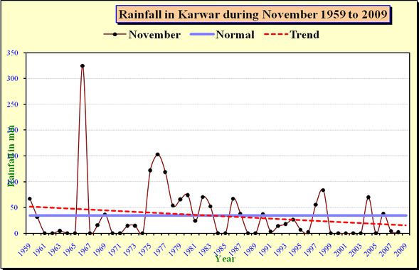
A look at rainfall data for the months June to November for the last 51 years (Figures 5.2-5.8) reveals that 18 times during these years, monthly rainfall had exceeded 1200 mm. Rainfall for July 1991 was 1436 mm, and for July 1999 it was 1421 mm. The fact that a monthly total of 690 mm rainfall for October 2009 created such havoc in the city and many other coastal villages raises a grave issue for immediate concern and precautionary action plans. Karwar taluk, in all probability, has transgressed its limits of growth, beyond the carrying capacity. The landslides and floods are warning signals of nature about the fragility of the region. Considering the high density of coastal population, the hilly nature of terrain and the fast pace of development, Karwar’s future will be at stake if timely steps are not taken to plan for future more meticulously and avert the recurrence of such calamities. Already as the headquarters of Uttara Kannada district, hosting India’s largest naval base, a nuclear power plant in Kaiga, a large port and a fisheries port, Karwar is brimming with population. Human settlements have come up everywhere, including in reclaimed backwater swamps of Kali, as well as dangerously close to fragile and geologically unstable hills. Kadwad village, the seat of two major landslides and 19 deaths, at the time of 2001 Census had 961 households and 4408 people. Why the landslides have not happened in the past and why should they all happen in early October this year? There is no single answer for this. Geologists consider Karwar as situated on a seismic zone. The vibrations due to blasting in the granite quarries of coastal hills and the passage of trains of the Konkan Railway through the fault lines and lineaments are believed to have contributed to the instability of the region. According to them the occurrence of minor seismic activity on October 2nd could not be ruled out. At the same time we have no seismographic records available for the fateful day; nor did people of Karwar experience any tremor. But one major causal factor for landslide that could be asserted with certainty is the abundance of global data, linking heavy and incessant rainfalls triggering off landslides. More of such landslides happen on deforested hill slopes that lose the shear strength as root entanglements stabilizing soil and rocks deteriorate in some years following tree cutting. Forest degradation is rampant in the coastal hills due to the pressures from rising population. The tree density and basal area, the vital indicators of the health of the hills and their ability to be immune from slope failures during spells of incessant rains, are far below standards for coastal hills of Karwar affected by landslides. The granitic base rocks, predominant in the hills, (granites which is fractured with joints), do not form a conglomerate with the soil matrix, unlike the laterites of the southern coast of Uttara Kannda. Despite the fact scores of these laterite covered southern hills are quarried for building stones, or their bases dug for roads, habitations and fields, landslides hardly happen here. Soils covering the lateritic hills, or the lateritic soils, harden on exposure to the hot sun, their clay part washed out in heavy rains from cut surface leaving behind vermiform tubules on an iron rich surface. Such stability is lacking for the Karwar hills with granite type rocks, which remain separate from the soil. During incessant rains, when great quantities of water seep into the hill soils, especially through stone and soil quarries, and hollows created by deterioration of root systems of cut trees the pore pressure increases and steep slopes especially lose their shear strength resulting in slope failures causing debris flows. Cutting the toes of hills for roads, housing and extension of holdings, widely being carried out all over Karwar, create weak points susceptible to debris flows. A look into the vegetational history of the coastal hills reveals that these belonged to what is administratively referred to as ‘minor forests’ set aside for meeting the biomass needs of the local population. Yet the vegetation was sufficient to maintain the integrity of hills by binding rocks and soils together, even during the peak rainy months subjected to incessant torrential rains that last through days. Sudden upsets in the traditional harmony of nature and humans got strained due to various factors. The establishment in 1980’s of INS Kadamba, the largest naval base of India, covering substantially the coastline of Karwar-Ankola, resulted in the evacuation of people from hundreds of houses, who had no place to move out but live in resettlement colonies or independent dwellings at the foot of hills, or in reclaimed backwaters which otherwise would have been washing the bases of the hills of Western Ghats that extend seaward, particularly in Karwar. The Kaiga atomic power plant also increased substantially pressure on Karwar, especially for housing. It was during this period of human settlement at Baithkol hill base, on the southern side of Kali River mouth, proliferated causing severe degradation of the hills, including tree cutting and cutting the hill base for housing sites. Removal of natural tree cover, however poor it was, from Kadwad hills, for raising cashew plantation, is to be considered unsuitable for local ecology. The hills are of very fragile nature, composed of soil, and soft laterite. Moored in the backwaters of Kali River the bases of these hills have water logging through most of the year. Water table is quite high in Kadwad, as evident from the local hills. The Zariwada hamlet is so named because of rich underground springs at the base of the hill. It takes some years for the root systems, that stabilized the substratum to disintegrate in the deforested hills. Such disintegrated spots become vulnerable to seepage of water into the hills during rains. Reviewing landslide susceptibility of Kerala Western Ghats, Kuriakose et al. (2008) conclude that initiation zone of most of the landslides was typical hollows generally having degraded natural vegetation. Here too the imminent cause is prolonged and intense rainfall and the resultant pore pressure variations. Despite the heavy rainfall in the highlands of Kerala, the past had reduced rates of slope instability. Landslides were activated due to anthropogenic activity, such as deforestation since early 18th century, terracing and obstruction of ephemeral streams, and cultivation of crops lacking capability to add root cohesion in steep slopes. According to a report in Geo Karnataka (October 19, 2009), Zariwada as the name suggests is a low-lying valley region characterized by seepage of ground water. Geomorphologically, the valley area can be recognized as a old stream (paleo-river) channel that formerly drained into the Kali River that flows in the north of Zariwada. The paleo-river channel is still connected to the Kali River and the groundwater seepage into the channel increases or decreases rhythmically according to high and low tides in the River. Zariwada colony of houses was located beside a huge clayey-laterite hill. The hill consists largely of reddish clays and was topped by thin cap of laterite. Granitic material underlies the clayey hill as can be seen in some cuttings. The clayey material from the hill was in demand for using as filler material in construction sites. That Zariwada is situated on a paleo-river channel is probable because the two hills and the lowlands that constitute Kadwad village itself, in satellite imagery, appear so. The village is in the course of streams draining the high hills of Western Ghats that slope towards Kali estuary. As such the hills are to be considered deposits of soils brought down from the Western Ghats by erosion, trapped and grown into the present form through millennia, between the tides of estuary and water-flow in the archaic streams, and stabilized by the growth of vegetation, mangroves at the base, and presumably, the tropical evergreen forests higher up, which have vanished today without a trace due to anthropogenic pressures. It is water-logging that has caused the looseness of soil and immaturity of laterite embedded in the interior of the hills. Such hills are very fragile, a fact demonstrated by torrential rains that pound the region seasonally, when human actions are not in agreement with basic geology and vegetation. Figure 5.1: Daily rainfall analysis (1984-2009) Figure 5.2: Rainfall variability during 1959 to 2009 in June Figure 5.3: Rainfall variability during 1959 to 2009 in July Figure 5.4: Rainfall variability during 1959 to 2009 in August Figure 5.5: Rainfall variability during 1959 to 2009 in September Figure 5.6: Rainfall variability during 1959 to 2009 in October Figure 5.7: Rainfall variability during 1959 to 2009 in November
|

 Move to Section 6