SECTION 3:
VEGETATION AND LANDSLIDES: APPLICABILITY TO COASTAL KARWAR
Introduction
Shallow rapid landslides are important erosion processes in steep terrain. The hill slope failures begin frequently in slightly concave depressions (Johnson and Sitar, 1990). These depressions are believed to be former landslide scars which have gradually filled with soil and organic materials through time (Shimokawa, 1984; Reneau et al., 1989). As soil depth in these depressions increases with time, the stability of the site decreases. This coupled with episodic occurrence of heavy precipitation (or snow melt) can sufficiently decrease soil strength resulting in another slope failure (Sidle and Terry, 1992).
The effect of changing root strength caused by vegetation management is another factor influencing slope stability in forested areas. When trees are cut, live roots begin to decay and there is generally a lag time before the root systems of newly planted or invading trees contribute substantial root strength to the site. Field studies in many parts of the world have shown that sites are most susceptible to landsliding about 2 to 12 years after forest cutting (Endo and Tsuruta, 1969; Megahan etal., 1978). This lag period corresponds to the time of minimum rooting strength as determined in several independent studies (Sidle and Terry, 1992). Vegetation conversion and range improvement practices on steep slopes can have a profound impact on site stability. In many areas, brush species are periodically removed by fire, herbicide or mechanical means to promote increased productivity of grasses. More dense grass cover offers resistance from surface erosion, the rooting strength of the grasses is negligible compared to most shrub or tree species (-ibid-).
Forest vegetation, especially tree roots, helps stabilize hillslopes by reinforcing soil shear strength. Root reinforcement is important on slopes where roots can extend into joints and fractures into bedrock or into a weathered transitional layer between the soil and bedrock. The stabilization of slopes by vegetation depends on the depth to which the roots grow. The more the roots penetrate a potential a shear plane, the greater is the chance that the vegetation will increase slope stability (Abe and Ziemer, 1990). Proper management of vegetation in steep forested areas can influence site stability by modifying rooting strength. Rooting strength is important factor in cohesion of substratum.
Bruijnzeel (2004) states that whereas a well developed tree cover can prevent shallow landslides up to about 1 m in depth due to the stabilizing forces of the root network, deep landslides of >3 m are not appreciably affected by forest cover. In cases of extreme climatic events such as hurricanes, trees may actually increase slope instability due to the trees’ weight and the susceptibility of particularly high trees to uprooting due to extreme storms, damaging the soil matrix. Bruijnzeel’s observations need not be universally applicable. In the context of Uttara Kannada district, which is for most part covered with the forest clad hills of Western Ghats, killer landslides are very unusual phenomenon. The removal of forest cover increases rapidly soil erosion and might trigger of landslides, especially in soft soils (as it happened in Kadwad and Baithkol) and soils with fractured granite rocks as in the Arga hills.
According to van Noordvijk (2005) forest or vegetation can potentially attenuate downstream effects of landslides. If the vegetation cover of the slope is in tact, vegetation downhill can act as a filter for dislodged soil, preventing the sediment entry into river channels. However, during rainstorms which exceed the water holding capacity of the soil, or earthquakes, such natural filter mechanisms may fail. Noordvijk states that, in contrast, clear-felling of slopes will increase the probability of landslides occurring, particularly after a few years when the roots are decomposed and loose their stabilizing force.
This could have been true with Karwar landslides. At Kadwad the hills were deforested already due to dense human population and nearness of Karwar city. Moreover the last trees were reported to be cut or uprooted some years ago for planting with cashew. With the passage of years root network would have decomposed. Their slope stabilizing force gone eventualities like exceptionally high rainfall, which could occur every few years at least, could trigger of landslides. Any ecologist would observe at the outset that the forest cover is very poor in all the hills where landslides have happened, as in Kadwad, Baithkol, Arga and DC’s residence hill. Therefore a rapid vegetational assessment was carried out in the region so as to find out whether impoverishment of vegetation could have also contributed to the landslides.
Thousands of landslides of medium to large dimensions have been occurring in the Himalayas every year. On an average, nearly 200 earthquakes of smaller magnitude, most of them undetected by local communities, occur every year in the Uttarakhand region of mid-Himalayas alone. According to V.C. Thakur, then Director of the Wadia Institute of Himalayan Geology, the uncontrolled downhill flow of water after heavy rains, particularly along barren slopes, was an important causative factor in these landslides. Apart from geological reasons, changes in the land use pattern, most obvious of these being the rapid destruction of forests which has left large tracts in the entire Himalayan region with denuded slopes (Kazmi, 1998). A study conducted in 1984 on the relationship between the building of the Mussoorie-Tehri road and landslides revealed that landslides caused more devastation in deforested rather than forested areas (-ibid-).
Deforestation and landslides in Karwar coastal hills
Vegetational status, almost all along the coastal hills of Uttara Kannada has been poor to very poor from historical times, although the climatic conditions are favourable for growth of multi-canopied evergreen forests that can be considered most ideal for slope protection. Slash and burn cultivation, or shifting cultivation (known as ‘kumri’ of ‘hakkal’) was widely practiced along the coastal hills during the pre and early British period. This was once considered the only suitable cultivation system for the hilly terrain receiving high seasonal rainfall. But as there were long gaps between two cycles of slash and burn, forest recovery to certain degree would happen during the fallow period. Landslides of vicious nature were, therefore, practically unknown, in coastal Uttara Kannada. Notable of the kumri cultivators were Kumri Marattis, Kunbis, Halakki Vokkals, Karivokkals etc. Taking note of the destruction this system of cultivation brought to forests, the British prohibited it by the close of the 19th century (Chandran, 1998). Passage of over 100 years since this ban on shifting cultivation could have been time enough for forest recovery through natural succession along the coastal hills of Karwar. But, to this day, though the hills appear to be under a green mantle of vegetation, there is prima facie insufficiency of tree growth. Therefore, we have studied the vegetation in some representative sample hills using a sampling method called ‘point-centred quarter’. The method is useful especially for estimating tree density and basal area. As forest cover has critical linkages to slope stability in many places such study would be useful in interpreting the landslides in the area and establishing linkages with vegetation.
To know the status of vegetation we sampled three representative areas as shown below:
- Zariwada hill in Kadwad village (Fig 3.1 and 3.2), the location of the fatal landslide
- Arga hill parallel to NH-17, and INS Kadamba, where several small landslides took place. The hill has vegetation somewhat similar to Baithkol and DC’s residence hill, the locations of other landslides
- Amdalli hill as a control sample, representative of the potential landslide prone granite-soil hills of coastal Karwar, undergoing the same pressures, but to a lesser degree. No landslides happened here so far, but caution has to be exercised to prevent further degradation of vegetation. The details of the study are given in Table 3.1.
Table 3.1: Vegetation analysis
| Study locality |
Estimated trees/ha |
Estimated basal area/ha (sq.m) |
% evergreen trees |
Mean ht (m) |
| Zariwada hamlet Kadwad |
76 |
2.356 |
3 |
3.8 |
| Arga hill |
44 |
5.92 |
20 |
5.9 |
| Amdalli hill |
435 |
26.84 |
87 |
10 |
Vegetation of Zariwada hill, Kadwad
The natural tree cover was stripped off (we do not know of the kind of secondary vegetation that prevailed prior to start of cashew plantation by the KCDC). Cashew was planted in a total area of 20 Ha. The hill, probably, as rest of the coastal hills of Karnataka had a shifting cultivation history. According to a local resident, before the arrival of present residents, the area had population mainly of Kunbis, who moved away from the place to interior areas (probably because of stoppage of Kumri cultivation). The locality was known to the elderly persons as ‘kumri-jaga’ meaning slash and burn cultivation area. The salient features of vegetation are as follows:
- The vegetation is of dense scrubby nature
- The tree density (76/ha) and basal area (2.35 sq.m) are extremely low. A terrain of this kind, with soft and moist soil, with soft laterite inside, should have over 350 trees/ha and basal area of over 25 sq.m/ha. Most trees (82%) belong to Anacardium occidentale (cashew), which have been planted many years ago by the Karnataka Cashew Development Corporation. Olea dioica is the lone evergreen tree in the sample. This relic species shows that there could have been more evergreen species before cashew was planted
- The tree density being low mean tree height is also very low at 3.8 m.
- A small sacred grove on the same slope that suffered landslide has some more remnants of past evergreen forest. These trees (outside the sample study area) has few large evergreens like Mammea suriga, Mangifera indica and Mimusops elengi. There is also a lone Sterculia guttata.
- Thorny bushes, herbs, grasses and climbers are many in the vegetation. More details of species are given in Tables 32. to 3.8.
Insufficiency of vegetation : Good tree cover would have been an effective insurance against erosion and landslides, especially on small hills. Whereas a good forest in Uttara Kannada normally has 350 plus trees, density of mere 76 trees/ha is too poor a protective cover. Whereas a multi-canopied vegetation is desirable as in most natural vegetation elsewhere there are only low, stunted and isolated cashew trees. Most trees bear marks of cutting and lopping. Coppices of Terminalia paniculata, Tectona grandis, Odina wodier etc are also found sparingly. That the slope instability, to a major extent, could have been caused by poor tree cover can be assumed from the fact in the split part of the hill hardly had any deep going dicot tree roots. Most plants are of shallow rooted shrubs and climbers and palms like Caryota urens. The lower slope bordering human habitation has very poor natural tree growth. Combined and cumulative impact of soil removal, toe cutting and torrential rains was in the form of the major landslide that destroyed homes and killed 19 people.
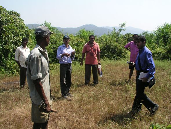
Fig: 3.1. Surveying vegetation of Zariwada hill in Kadwad
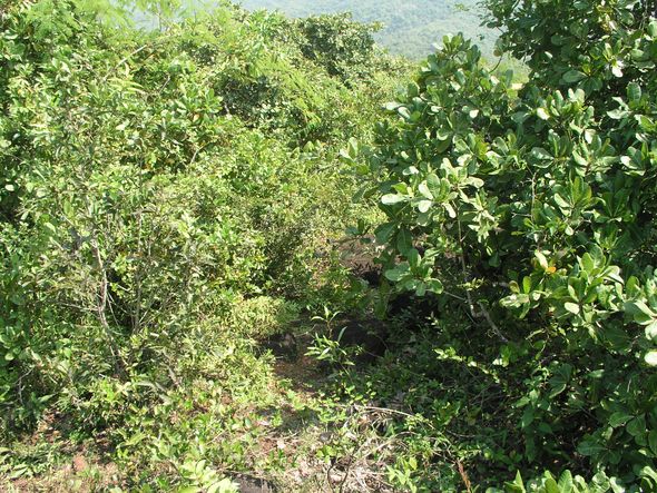
Fig: 3.2. View of the scrubby vegetation of the Zariwada hill
Arga hills
A steep series of hills running close to the Arabian Sea these are promontories of the Western Ghats. In this part of Karwar the NH-17 mostly passes through the base of these hills. The narrow strip of coast below is occupied by INS Kadamba. The high wall separating the naval base from NH-17 has been breached in many places due to landslides and storm waters. A series of landslides have taken place along this range of hills obstructing the NH-17. Granite quarries are found in these hills. Although the hill sides are covered with a dense mantle of vegetation the trees are very sparse, just 44/ha, whereas their number should have been over 350/ha to provide more stable conditions, as most forests of Uttara Kannada elsewhere are. The salient features of vegetation (Fig. 3.3) are as follows:
- Dense scrubby vegetation with short bamboos (Oxytenanthera stocksii)
- Very low tree density (44/ha) and low basal area (5.92 sq.m). The ideal would have been over 350 trees/ha and basal area of over 25 sq.m
- The tree density being low mean tree height is also low at about 6m. To develop multi-storied vegetation for greater soil protection and stability to the ground the general canopy height should be at least 10 m.
-
Most trees are of deciduous type, whereas the ideal would be multi-storied evergreen forest affording more effective soil protection. Notable of the trees are Ficus arnottiana (Kallaswatta), Holarrhena antidysenterica (Kodasa), Ixora brachiata (Gurani), Schleischera oleosa (Sagadi), Syzygium cumini (Neerlu) and Terminalia paniculata (Kindal). Occasionally small teak trees and Sterculia urens also are found. The nature of the tree vegetation is indicative of repeated fires (at least until the immediate past); eroded and stony soils indicate continuing ongoing human impacts which can be deciphered from dense growth of thorny bushes and entanglement of climbers (Table 3.2-3.8 for more details on speices).
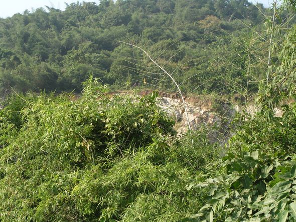
Fig: 3.3. Vegetation of Arga hills (note stone quarry inside forest)
Amdalli hill
This hill is further south, high and steep, bordering the Ankola taluk. Bordering the coastal zone and yet merging with the Western Ghats the hill is to the east of the NH-17 and is not affected by road cutting unlike the Arga hills. No landslides occurred here, may be due to lower population of the village and less of soil disturbances or quarrying. The rocks in this hill are also of granitic nature. We studied this hill to compare the vegetation with that of landslide localities, and to know whether vegetation can provide greater stability to hill slopes. The tree number estimated is much higher at 435/ha, and also the basal area (26.84 sq.m/ha). A greater proportion of trees (87%) are evergreen. The vegetation however seems to be on fast decline due to rising human pressures. The salient features of the vegetation are as follows:
- The forest is denser but degradation process is rampant due to rising human pressures. Illegal cutting of small timber and removal of firewood have been noticed during our study
- The tree density at 435/ha is much healthier than the coastal hills nearer to Karwar that have suffered from landslides. The degradation of vegetation is higher closer to the habitation in the valley. The basal area of 26.84 sq.m/ha is very good for any of the coastal hills of Uttara Kannada district. At the same time geological composition of the hill (mainly of granite rock masses and soil not forming a consolidated substratum) requires that the any further vegetational degradation can destabilize the slopes and create landslides here too under conditions of episodical heavy rains and even mild seismicity.
- The present vegetation indicates that the forest would have been fully evergreen forest. The presence of Western Ghat endemics like Diospyros candolleana, Holigarnagrahamii are indicators of such past.Human interference could be the reason for a mix of deciduous and secondary evergreen species like Terminalia tomentosa, Flacourtia montana, Syzygium caryophyllata etc.
-
Forest degradation is ongoing as can be judged from commoner occurrence of thorny species and climbers, from firewood and poles collection and even traces of illegal sawing of timber (Figure 3.4).
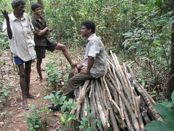
Figs: 3.4. Forest degradation in Amdalli hill
Landslide prevention to be considered environmental service of forests
Control of landslides should be today a matter of great concern for all the residents living alongside and below hill slopes. For that matter, Karwar city itself is strategically close to the steep hills of Western Ghats. The landslide in the Baithkol fisheries port area, fortunately happened just missing the fisheries port proper as well as the densely populated colony itself. Huge sized granite boulders along with thousands of tonnes of soil came rushing down the steep hill slopes onto the NH-17 and beyond in several places. As the road was blocked human casualties did not happen on the NH. The people of Zariwada were unlucky, with 19 buried alive and several houses destroyed or damaged.
A striking factor here is the impoverished vegetational cover on the hills. Coastal and Malnad taluks of Uttara Kannada receive every year over 3000 mm of rainfall. Either episodically or continuously for several days at a stretch during the monsoon months, heavy rains pound the region. Whereas a healthy tree cover is of paramount necessity the situation of coastal Karwar is precarious. Added to that there is also high degree of human impact on the hills in the form of toe cuttings, to expand their holdings, both for houses and agriculture, stone quarrying and soil mining. The road cuttings are also improper in most places and attention paid to drainage is scanty as well. Compounding to the causes are willful removal of natural vegetation for planting cashew trees on the hills of Kadwad, by the Karnataka Cashew Development Corporation. Cashew trees are poorly grown on those hills, shallow rooted and insufficient to hold together soil and rocks in a region battered by torrential seasonal rains. Landslide prevention is to be considered as an environmental service of forest vegetation, especially in the hilly terrain of coastal Karwar, where the dominating rock type is granite which does not form a consolidated mass with soil. This is unlike in other coastal taluks like Kumta, Honavar or Bhatkal where the main rock type is laterite. Even underneath degraded vegetation laterite forms a conglomerate with the loamy soil, preventing landslides, except when hillside is cut too deep or unscientifically. However, as pressures rise unregulated on natural ecosystems their carrying capacities are transgressed, more so in the fragile evergreen forest belt of Uttara Kannada.
Table 3.2: Sahibapad-Kadwad landslide area: Trees in sampled plots
| Sl |
Family |
Species |
Habit |
Distribution |
| 1 |
Meliaceae |
Aglaia elaeagnoides |
Shrub |
Oriental-Indomalaysia |
| 2 |
Sapindaceae |
Allophylus cobbe |
Shrub |
Oriental-South India, Sri Lanka, South East Asia |
| 3 |
Liliaceae |
Asparagus racemosus |
Climber |
Paletropics |
| 4 |
Euphorbiceae |
Bridelia scandens |
Shrub |
Oriental-Western Ghats |
| 5 |
Combretaceae |
Calycopteris floribunda |
Climber |
Oriental-Indomalaysia |
| 6 |
Apocynaceae |
Carissa carandus |
Shrub |
Oriental-Peninsular India |
| 7 |
Lauraceae |
Cassytha filiformis |
Climber |
India, Sri Lanka, old world Tropics |
| 8 |
Verbenaceae |
Clerodendrum viscosum |
Shrub |
Oriental-Indomalaysia |
| 9 |
Menispermaceae |
Cyclea peltata |
Climber |
Oriental-Western Ghats |
| 10 |
Fabaceae |
Dalbergia climber |
Climber |
|
| 11 |
Dioscoriaceae |
Dioscorea spp |
Climber |
|
| 12 |
Myrsinaceae |
Embelia tsjeriam-cottam |
Shrub |
Oriental-India, Myanmar, Sri Lanka |
| 13 |
Myrtaceae |
Eucalyptus sp |
|
|
| 14 |
Asteraceae |
Eupatorium odoratum |
Shrub |
Neotropical |
| 15 |
Euphorbiaceae |
Gymnosporia rothiana |
Shrub |
|
| 16 |
Asclepiadaceae |
Hemidesmus indicus |
Climber |
Oriental-Peninsular India, Sri Lanka |
| 17 |
Apocynaceae |
Holarrhena antidysenterica |
Shrub |
Oriental-Indomalaysia |
| 18 |
Rubiaceae |
Ixora coccinea |
Shrub |
Oriental-Western Ghats, Sri Lanka |
| 19 |
Euphorbiaceae |
Jatropha gosypifolia |
Shrub |
Neotropics-Brazil |
| 20 |
Anacardiaceae |
Lannea coromandelica |
Tree |
Oriental-South Asia, Indomalaysia |
| 21 |
Leeaceae |
Leea indica |
Shrub |
Oriental to Australia |
| 22 |
Melastomaceae |
Memecylon edule |
Shrub |
India, Sri Lanka, Myanmar, Malasia, Thailand |
| 23 |
Passifloraceae |
Passiflora sp |
climber |
|
| 24 |
Verbenaceae |
Premna obtusifolia |
Shrub |
Oriental-Indomalaysia |
| 25 |
Cyperaceae |
Scleria sp |
Shrub |
|
| 26 |
Euphorbiaceae |
Sepium insigne |
Tree |
|
| 27 |
Myrtaceae |
Syzygium caryophyllatum |
Tree |
Oriental-South India, Sri Lanka |
| 28 |
Combretaceae |
Terminalia paniculata |
Tree |
Oriental-Peninsular India |
| 29 |
Rhamnaceae |
Ziziphus oenoplia |
Shrub |
Pantropics |
| 30 |
Rhamnaceae |
Ziziphus rugosa |
Shrub |
Oriental-India, Sri Lanka |
Table 3.3: Sahibapad-Kadwad landslide area: Plants in sampled shrub layer
| Sl |
Family |
Species |
Habit |
| 1 |
Fabaceae |
Acacia auriculiformis |
Tree |
| 2 |
Rubiaceae |
Adina cordifolia |
Tree |
| 3 |
Verbenaceae |
Avicennia officinalis |
Tree |
| 4 |
Poaceae |
Bambusa spp |
|
| 5 |
Acanthaceae |
Blepharis asperrima |
herb |
| 6 |
Cyperaceae |
Cyperus malacensis |
herb |
| 7 |
Fabaceae |
Derris spp |
Climber |
| 8 |
Convolvulaceae |
Evolvulus aslinoides |
herb |
| 9 |
Euphorbiaceae |
Excoecaria agallocha |
Shrub |
| 10 |
Cyperaceae |
Fimbristylis ferrugenia |
herb |
| 11 |
Tiliaceae |
Grewia microcos |
Tree |
| 12 |
Poaceae |
heteropogon contortus |
herb |
| 13 |
Apocynaceae |
Ichnocarpus frutescens |
Climber |
| 14 |
Poaceae |
Ischemum indicum |
herb |
| 15 |
Poaceae |
Ischemum semisagittatum |
herb |
| 16 |
Verbenaceae |
Lantana camara |
Shrub |
| 17 |
Euphorbiaceae |
Macaranga peltata |
Tree |
| 18 |
Clusiaceae |
Mammea suriga |
Tree |
| 19 |
Anacardiaceae |
Mangifera indica |
Tree |
| 20 |
Santalaceae |
Osyris quadripartita |
Tree |
| 21 |
Fabaceae |
Pongamia pinnata |
Tree |
| 22 |
Rhizophoraceae |
Rhizophora apiculata |
Tree |
| 23 |
Sonneratiaceae |
Sonneratia alba |
Tree |
| 24 |
Sonneratiaceae |
Sonneratia caeseolaris |
Tree |
| 25 |
Rutaceae |
Zanthoxylum rhetsa |
Tree |
Table 3.4: Saihibapad:Kadwad landslide area-Other opportunistic plants
| Sl |
Family |
Species |
Habit |
Distribution |
| 1 |
Meliaceae |
Aglaia elaeagnoides |
Shrub |
Oriental-Indomalaysia |
| 2 |
Sapindaceae |
Allophylus cobbe |
Shrub |
Oriental-South India, Sri Lanka, South East Asia |
| 3 |
Sapindaceae |
Anacardium occidentale |
Tree |
Native to South America |
| 4 |
Euphorbiaceae |
Aporosa lindleyana |
Tree |
Oriental-Peninsular India, Sri Lanka |
| 5 |
Combretaceae |
Calycopteris floribunda |
Climber |
Oriental-Indomalaysia |
| 6 |
Rubiaceae |
Canthium parviflorum |
Shrub |
Oriental-Western Ghats |
| 7 |
Apocynaceae |
Carissa carandus |
Shrub |
Oriental-Peninsular India |
| 8 |
Lauraceae |
Cassytha filiformis |
Climber |
India, Sri Lanka, old world Tropics |
| 9 |
Verbenaceae |
Clerodendrum viscosum |
Shrub |
Oriental-Indomalaysia |
| 10 |
Menispermaceae |
Cyclea peltata |
Climber |
Oriental-Western Ghats |
| 11 |
Fabaceae |
Dalbergia climber |
Climber |
|
| 12 |
Myrsinaceae |
Embelia tsjeriam-cottam |
Shrub |
Oriental-India, Myanmar, Sri Lanka |
| 13 |
Asteraceae |
Eupatorium odoratum |
Shrub |
Neotropical |
| 14 |
Tiliaceae |
Grewia microcos |
Shrub |
Oriental-Tropical Asia |
| 15 |
Rubiaceae |
Ixora coccinea |
Shrub |
Oriental-Western Ghats, Sri Lanka |
| 16 |
Melastomaceae |
Memecylon edule |
Shrub |
India, Sri Lanka, Myanmar, Malasia, Thailand |
| 17 |
Passifloraceae |
Passiflora sp |
climber |
|
| 18 |
Euphorbiaceae |
Sepium insigne |
Tree |
|
| 19 |
Combretaceae |
Terminalia paniculata |
Tree |
Oriental-Peninsular India |
| 20 |
Rhamnaceae |
Ziziphus oenoplia |
Shrub |
Pantropics |
| 21 |
Rhamnaceae |
Ziziphus rugosa |
Shrub |
Oriental-India, Sri Lanka |
Table 3.5: Plants in Kadwad 1 landslide area
| Sl |
Family |
Species |
Habit |
Distribution |
| 1 |
Poaceae |
Bambusa spp |
|
|
| 2 |
Combretaceae |
Calycopteris floribunda |
Climber |
Oriental-Indomalaysia |
| 3 |
Apocynaceae |
Carissa carandus |
Shrub |
Oriental-Peninsular India |
| 4 |
Dioscoriaceae |
Dioscorea spp |
Climber |
| 5 |
Moraceae |
Ficus arnottiana |
Tree |
Oriental-India, Sri Lanka |
| 6 |
Apocynaceae |
Holarrhena antidysenterica |
Shrub |
Oriental-Indomalaysia |
| 7 |
Rubiaceae |
Ixora brachiata |
Tree |
Oriental-Western Ghats |
| 8 |
Anacardiaceae |
Lannea coromandelica |
Tree |
Oriental-South Asia, Indomalaysia |
| 9 |
Melastomaceae |
Memecylon edule |
Shrub |
India, Sri Lanka, Myanmar, Malasia, Thailand |
| 10 |
Sapindaceae |
Schleichera oleosa |
Tree |
Oriental-Indomalaysia |
| 11 |
Myrtaceae |
Syzygium cumini |
Tree |
Oriental-Indomalaysia |
| 12 |
Verbenaceae |
Tectona grandis |
Tree |
Oriental-Indomalaysia |
| 13 |
Verbenaceae |
Tectona grandis |
Tree |
Oriental-Indomalaysia |
| 14 |
Combretaceae |
Terminalia paniculata |
Tree |
Oriental-Peninsular India |
| 15 |
Rhamnaceae |
Ziziphus oenoplia |
Shrub |
Pantropics |
Table 3.6: Plants in Binaga granite quarry landslide sampled area
| Sl |
Family |
Species |
Distribution |
| 1 |
Euphorbiaceae |
Aporosa lindleyana |
Oriental-Peninsular India, Sri Lanka |
| 2 |
Rutaceae |
Atalantia racemosa |
Oriental-India, Sri Lanka |
| 3 |
Rubiaceae |
Canthium diciccum |
Oriental-South India, Myanmar |
| 4 |
Arecaceae |
Caryota urens |
Tropical Asia |
| 5 |
Ebenaceae |
Diospyros candolleana |
Oriental-Western Ghats |
| 6 |
Ebenaceae |
Diospyros montana |
India-Tropical Australia |
| 7 |
Flacourtiaceae |
Flacourtia montana |
Oriental-Western Ghats |
| 8 |
Anacardiaceae |
Holigarna grahamii |
Oriental-Western Ghats |
| 9 |
Rubiaceae |
Ixora brachiata |
Oriental-Western Ghats |
| 10 |
Oleaceae |
Olea dioica |
Oriental-Western Ghats, Deccan plataeu |
| 11 |
Myrtaceae |
Syzygium caryophyllatum |
Oriental-South India, Sri Lanka |
| 12 |
Myrtaceae |
Syzygium spp |
|
| 13 |
Combretaceae |
Terminalia alata |
Oriental-India |
Table 3.7: Trees in Amdalli non-landslide sampled area
| Sl |
Family |
Genera |
Species |
habit |
Distribution |
| 1 |
Lauraceae |
Actinodaphne |
hookeri |
Tree |
Oriental-Western Ghats |
| 2 |
Meliaceae |
Aglaia |
elaeagnoides |
Tree |
Oriental-Indomalaysia |
| 3 |
Euphorbiaceae |
Aporosa |
lindleyana |
Tree |
Oriental-Peninsular India, Sri Lanka |
| 4 |
Rutaceae |
Atlantia |
racemosa |
Tree |
Oriental-India, Sri Lanka |
| 5 |
Ebenaceae |
Diospyros |
candolleana |
Tree |
Oriental-Western Ghats |
| 6 |
Ebenaceae |
Diospyros |
buxifolia |
Tree |
Oriental-Indomalaysia |
| 7 |
Ebenaceae |
Diospyros |
paniculata |
Tree |
Oriental-Western Ghats |
| 8 |
Rutaceae |
Glycosmis |
pentaphylla |
Shrub |
Oriental-South India, Sri Lanka |
| 9 |
Rubiaceae |
Ixora |
brachiata |
Tree |
Oriental-Western Ghats |
| 10 |
Myristicaceae |
Knema |
attenuata |
Tree |
Oriental-Western Ghats |
| 11 |
Leeaceae |
Leea |
indica |
Shrub |
Oriental to Australia |
| 12 |
Euphorbiaceae |
Macaranga |
peltata |
Tree |
Oriental-Western Ghats, Sri Lanka |
| 13 |
Melastomataceae |
Memecylon |
talbotianum |
Shrub |
Oriental-Western Ghats |
| 14 |
Lauraceae |
Neolitsea |
scrobiculata |
Tree |
Oriental-Western India |
| 15 |
Anacardiaceae |
Nothopegia |
colebrookeana |
Tree |
Oriental-Western Ghats |
| 16 |
Oleaceae |
Olea |
dioica |
Tree |
Oriental-Western Ghats, Deccan |
| 17 |
Rubiaceae |
Psychotria |
dalzellii |
Shrub |
Oriental-Western Ghats |
| 18 |
Myrtaceae |
Syzygium |
sp |
Tree |
|
| 19 |
Flacourtiaceae |
Flacourtia |
montana |
Tree |
Oriental-Western Ghats |
| 20 |
Lauraceae |
Litsea |
laevigata |
Tree |
Oriental-Western Ghats |
| 21 |
Anacardiaceae |
Mangifera |
indica |
Tree |
Oriental-Western Ghats |
| 22 |
Rutaceae |
Acronychia |
pedunculata |
Tree |
India, Sri Lanka, Laos, Cambodia, Vietnam, Taiwan, Sumatra, Borneo, Phillipines, Java |
| 23 |
Anacardiaceae |
Holigarna |
grahamii |
Tree |
Oriental-Western Ghats |
| 24 |
Sapotaceae |
Mimusops |
elengi |
Tree |
Oriental-Indomalaysia |
| 25 |
Arecaceae |
Calamus |
thwaitesii |
Shrub |
Oriental-Western Ghats |
| 26 |
Clusiaceae |
Garcinia |
morella |
Tree |
Oriental-India, Sri Lanka, Malesia |
| 27 |
Annonaceae |
Sageraea |
laurifolia |
Tree |
Oriental-Western Ghats |
|


 Move to Section 4