Annexure I I : Engineering Geology Division, Operations Karnataka and Goa Geological Survey of India, Bangalore
A NOTE ON THE PRELIMINARY POST DISASTER INVESTIGATION OF LANDSLIDES OCCURRED DURING OCTOBER 2009 IN KARWAR TALUK, UTTAR KANNADA DISTRICT, KARNATAKA
(Lateral priority Item – I)
FS 2009-10
A.K.MISHRA
GEOLOGIST (JR)
Introduction
The landslides occurred during the monsoon showers of September and October 2009 in Karwar taluk, Uttara Kannada dist., Karnataka claimed 19 lives, destroyed properties and affected communication lines. The Preliminary investigation of the landslides was taken up on priority as per the instruction received from the Dy.Director General, Op: Karnataka and Goa, Geological Survey of India, Bangalore to assess the nature, causes, the future risk and vulnerability at the sites. Communications were also received from LHIM Division, New Delhi, Chairman, Western Ghat Task Force and telephonic request of Addl. Dy.Commissioner, Uttar Kannada Dist, Karwar to Director (CT), Op: Karnataka and Goa, regarding the urgency of the investigation. The preliminary investigation was carried out at the following sites on 13.10.2009 and 14.10.2009.
- Landslide at Kadvad village, Karwar Taluk, Karwar
- Landslide near Forest Naka, Kadvad village, Karwar Taluk, Karwar
- Landslides along NH17 between Ankola and Karwar: Landslide 1, Landslide 2 and Landslide 3
- Landslide near Karwar port: Landslide 4, Landslide 5 and Landslide 6
Location of landslides
Landslides of different magnitudes were reported at 21 locations, two slides in the vicinity of Kadvad village, fifteen slides along NH 17 between Ankola and Karwar and five slides along the road connecting to the Port at Baithkhol. The details of the landslides as provided by the forest officials of Karwar are listed below. All the slides are located in Karwar taluk and fall in toposheet no 48J/1 and occurred on 2nd October 2009 (as per local authorities).
| Sl no |
Slide location |
Latitude and Longitude |
Approximate volume of slide material |
| 1 |
Kadvad
(Zariwada) |
14o52’40.2”N
74o10’39.8”E |
750,000 Cu.m |
| 2 |
Kadvad
(Near Forest Naka) |
14o49’59.2”N
74o10’47.6”E |
400,000 Cu.m |
| 3 |
Agra (NH 17) |
14o46’53.4”N
74o08’43.1”E |
6000 Cu.m |
| 4 |
Agra (NH 17) |
14o46’51.2”N
74o08’47.3”E |
4000 Cu.m |
| 5 |
Baithkhol (near port) |
14o48’13.3”N
74o06’49.7”E |
10,000 Cu.m |
| 6 |
Baithkhol (near port) |
14o48’09.8”N
74o06’50.8”E |
15,000 Cu.m |
| 7 |
Baithkhol (near port) |
14o48’16.1”N
74o06’49.3”E |
25,000 Cu.m |
| 8 |
Baithkhol (near port) |
14o48’16.5”N
74o06’47.9”E |
30,000 Cu.m |
| 9 |
Baithkhol (near port) |
14o48’07.4”N
74o06’49.8”E |
8,000 Cu.m |
| 10 |
Shirwad |
14o48’38.7”N
74o10’47.6”E |
100,000 Cu.m |
| 11 |
Mandralli |
14o50’50.2”N
74o09’22.7”E |
45,000 Cu.m |
| 12 |
Makeri |
14o49’21.8”N
74o10’17.6”E |
5,000 Cu.m |
| 13 |
Makeri |
14o49’15.5”N
74o10’17.5”E |
4,500 Cu.m |
| 14 |
Makeri |
14o49’15.3”N
74o10’17.5”E |
3,800 Cu.m |
| 15 |
Baad
(Murlidhramath) |
14o48’25.1”N
74o08’13.2”E |
5,000 Cu.m |
| 16 |
Baad |
14o48’14.5”N
74o07’22.4”E |
3,000 Cu.m |
| 17 |
Binga (NH 17) |
14o47’26.2”N
74o06’53.5”E |
500 Cu.m |
| 18 |
Binga (NH 17) |
14o47’27.9”N
74o06’59.0”E |
1500 Cu.m |
| 19 |
Binga (NH 17) |
14o46’53.9”N
74o08’10.0”E |
35,000 Cu.m |
| 20 |
Agra (NH 17) |
14o46’58.9”N
74o08’29.2”E |
50,000 Cu.m |
| 21 |
Agra (NH 17) |
14o46’58.4”N
74o08’29.2”E |
10,000 Cu.m |
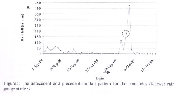
Rainfall : The investigated area falls in Western Ghat and receives a high average annual rainfall. The antecedent and precedent rainfall pattern shows an unprecedented rise in the quantum of rainfall from 30th September 2009 to 4th October 2009. As per the information from the local authorities, all the landslides occurred on 2nd October 2009 even though the maximum daily rainfall received was on 3rd Oct 2009 which is nearly 2.5 times more than the rainfall received on previous day. The immediate trigger for all the slides is observed to be the high rainfall. The rainfall data from 1st September 2009 to 13th October 2009, as recorded at Karwar rain gauge station is as follows:
| Date |
Rainfall (in mm) |
|
Date |
Rainfall (in mm) |
|
Date |
Rainfall (in mm) |
| 1-Sep-09 |
19.9 |
|
16-Sep-09 |
4.7 |
|
1-Oct-09 |
39.5 |
| 2-Sep-09 |
57.9 |
|
17-Sep-09 |
0 |
|
2-Oct-09 |
179.6 |
| 3-Sep-09 |
30 |
|
18-Sep-09 |
0 |
|
3-Oct-09 |
423.6 |
| 4-Sep-09 |
38.4 |
|
19-Sep-09 |
8.2 |
|
4-Oct-09 |
34.9 |
| 5-Sep-09 |
64 |
|
20-Sep-09 |
0 |
|
5-Oct-09 |
1 |
| 6-Sep-09 |
49.6 |
|
21-Sep-09 |
4.4 |
|
6-Oct-09 |
10.4 |
| 7-Sep-09 |
26.4 |
|
22-Sep-09 |
0 |
|
7-Oct-09 |
0 |
| 8-Sep-09 |
8.8 |
|
23-Sep-09 |
0 |
|
8-Oct-09 |
0 |
| 9-Sep-09 |
1 |
|
24-Sep-09 |
2.5 |
|
9-Oct-09 |
0 |
| 10-Sep-09 |
17.3 |
|
25-Sep-09 |
0.7 |
|
10-Oct-09 |
0 |
| 11-Sep-09 |
2.4 |
|
26-Sep-09 |
4.4 |
|
11-Oct-09 |
0 |
| 12-Sep-09 |
41.8 |
|
27-Sep-09 |
0.6 |
|
12-Oct-09 |
0 |
| 13-Sep-09 |
0 |
|
28-Sep-09 |
0 |
|
13-Oct-09 |
0 |
| 14-Sep-09 |
0 |
|
29-Sep-09 |
6 |
|
|
|
| 15-Sep-09 |
10.7 |
|
30-Sep-09 |
118.2 |
|
|
|
Data Source: Dy. Commissioner’s office, Uttar Kannada Dist., Karwar
ASSESSMENT OF INDIVIDUAL LANDSLIDE
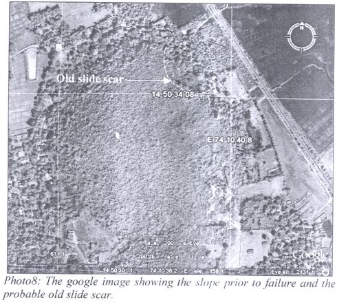
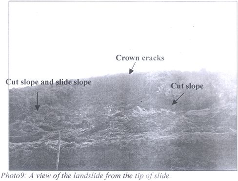
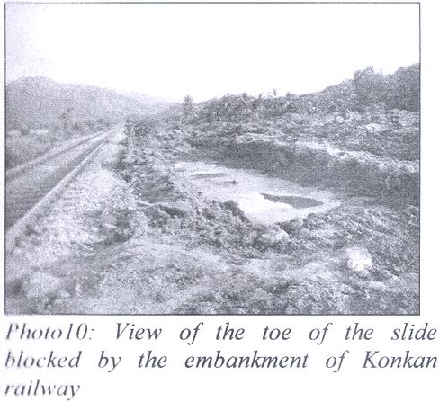
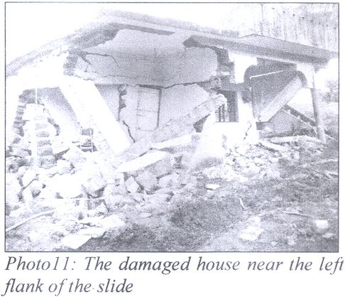
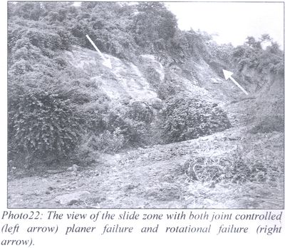
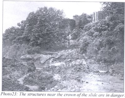
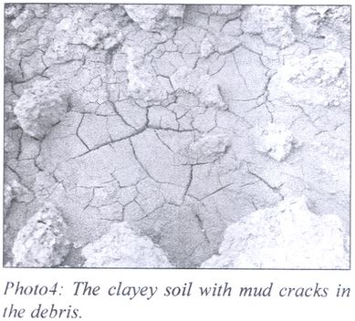
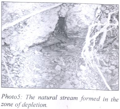
A) Landslide at Kadvad village, Karwar taluk, Karwar (Photo: 1-11) : The Kadvad landslide occurred at 1615hrs on 2nd October 2009 killing 19 people and completely destroying nine houses, coconut plantation and livestock.
Location and Physiography : The slide is located in toposheet no 48J/1 at latitude 14o50’35.6”N and longitude 74o10’36.4”E, nearly 6 km northwest of Karwar town. The landslide occurred in the northeast slope of the NW-SE trending mound. The maximum height of the mound is 65m above msl with a slope angle of ~20o. The foot hill is habitated all round. The spur of the mound runs into the marshy land near the bank of Kali River on its three sides. The original hill profile shows small depression/streams draining into Kali River from northeast and southwest direction.
Land use and Land cover : The slope has been modified for making formations for habitation and plantation for a long time. The modification includes (as data gathered from local residents and inferred from the site condition) three levels of benching with construction of houses and plantation of coconut trees. The slope is moderately vegetated with shrubs and cashew plants both having low root and shoot ratio.
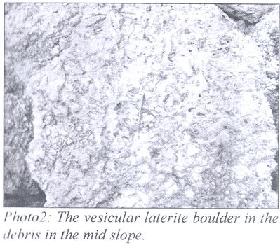
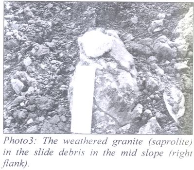
Geology at site : The litho units exposed at the site includes vesicular laterite with predominantly tubular cavities, clayey soil, saprolite (weathered granite) and granite. A small lensoid body of lithomarge clay layer occurs near the head scarp at the left flank.
Slide morphometry : The slide is a large (>20,000 m2 area in plan), very fast, deep seated (depth of failure more than 20m) rotational debris slide. The different morphometric parameters of the slide are as follows:
- Length of slide: 250-300m
- Width of slide: 60 m
- Depth of slide: ~30m
- Scarp width: ~60m
- Scarp depth: ~20m
- Scarp angle: ~vertical to concave
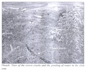
- Crown cracks observed
- Run out distance: ~300m
- Cut slope angle near the toe: 90o
- Cut slope height near the toe: 20m
- Slide direction: N36oE
- Slope prior to failure: 20o
- Slope after failure: 10o- 15o
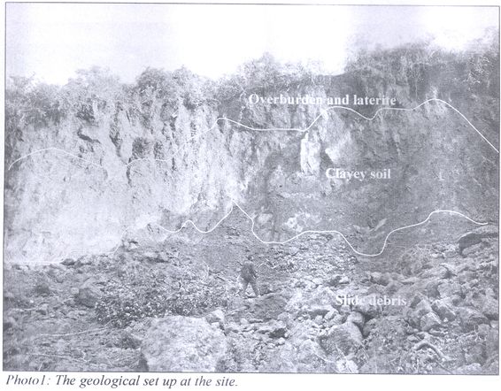
Slide material : The slide material in the zone of accumulation and depletion is debris comprises of different fraction of laterite, sandy lateritic soil, clayey soil and weathered granite material. The size of different fractions varies from huge lateritic bloulders to clay size, with dominant finer material.
Causes of the slide : The causes of the slide as observed during the investigation are as follows:
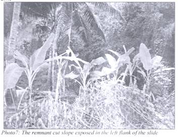
- The original slope angle being very low ~20o, the slope was stable prior to human interference. The modification of the slope by cutting 15-20m vertical slope (as observed in the left and right flanks of the slide zone) for settlement and plantation increased instability.
- The 10-15m thick clayey soil layer, between laterite and saprolite layers, being impervious was oversaturated during the antecedent rainfall and was responsible for development of high pore pressure. The pore pressure cumulatively with lateral pressure due to swelling of oversaturated clay rich horizon may have increased the driving force.
- Even though the slope was moderately vegetated with shrubs and cashew plants, the vegetation added dead weight on the failed slope as these plants do not have deep penetrating root system to hold the slope material intact ( as the plane of failure of the slide is more than 20m).
- As per information received from local authorities and some local residents there was an excavation in front of the slope for providing soil for the construction of the embankment for Konkan Railway alignment. Even though the excavation depth could not be confirmed but its location was somewhere near the front of the slide slope. The instability was induced due to the excavation (toe cutting into the slope) which has increased the relative slope height, the volume and weight of material above the toe.
- The rise in the stagnated water level in the marshy area in front of the mound during the ensuing rainfall might have decreased the volume of water drained out of the mound thus increasing the water content of the slope forming material with subsequent rise of water table.
- Even though percolation through vesicular laterite is high the drainage facility in the area was poor to drain out the excess infiltrating water from the slope.
Triggering mechanism : The trigger for the slide was the continuing high rainfall and subsequent increase in the pore pressure due to impermeable clayey soil horizon.
Recommendations : As per the site condition the following measures are recommended:
- The houses in the vicinity of the slide zone are to be shifted to safer places.
- The hanging crown part needs to be graded as it is still unstable (as subsidence and crown cracks were observed). The major part of the intact slope exposed is either laterite or clayey soil hence the vertical, 20m high crown scarp should be graded to 35o-45o.
- The water logged areas and rills present in the slope (ponding of water in the midslope and the rills developed near the head scarp) are to be diverted or suitably drained out of the slope.
- Plantation in the slide zone with deep rooted plants in staggered manner is essential to stop future landslides of local nature in the slide debris. It is to be noted that deep seated slides cannot be protected with biogeotechnical measures.
- For long term stability at the site of landslide and the adjoining slopes of the mound, detail study of the whole area as a single unit should be taken up for landslide microzonation.
- The long term remedial measures is to be proposed after detail investigation at the site of landslide and it will depend on
- The type of future landuse contemplated for the area.
- Development plans envisaged for such type of landuse pattern.
- Cost/economics
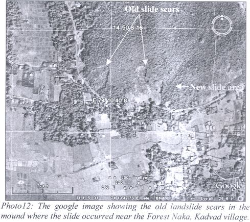
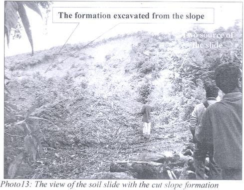
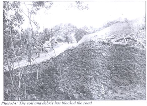
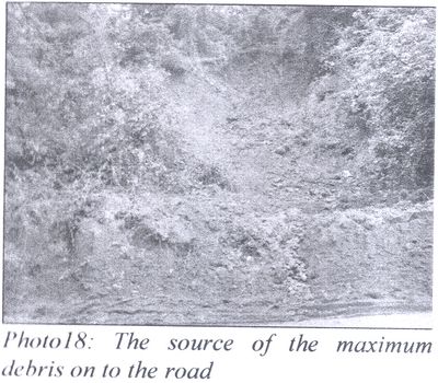
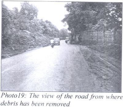
B) Landslide near Forest Naka, Kadvad village, Karwar taluk, Karwar (Photo: 12-14) : The Landslide near Forest Naka, Kadvad village occurred on 2nd October 2009 and blocked the road.
Location and Physiography : The slide is located in toposheet no 48J/1 at latitude 14o49’59.2”N and longitude 74o10’47.6”E, nearly 5km northwest of Karwar town. 400,000 Cu.m volume of debris and soil moved down slope blocking the road connecting to Kadvad village from SH6. The landslide occurred in the southeast slope of the E-W trending hill. The maximum height of the area is 78m above msl with a slope angle of ~30o. The foot hill is habitated in the south and south east slopes. The original hill profile shows small streams running into Kali river from northeast and southwest direction.
Slide morphometry : The slide is very fast, large, deep-seated rotational soil slide. The morphometric parameters of the slide are as follows:
Length of slide:250-300m, Width of slide: 100m, Depth of slide: ~15-20m, Scarp width: ~75m, Scarp depth: ~15m, Scarp angle:~50o to vertical, Run out distance: ~ 300m, Cut slope angle near the toe: Vertical, Cut slope height near the toe: 10m, Slide direction: S15oE, Slope prior to failure: ~20o, Slope after failure: 10o-15o
Slide material : The slide material in the zone of accumulation and depletion is soil and debris comprises of different fraction of lateritic soil (sand to clay size), and weathered granite.
Causes of the slide : The causes of the slide as observed during the investigation are as follows:
- The cut slope for the road formation
- As per the information provided by local authorities there was excavation at the
- midslope to flatten the slope. This has increased the driving force due to the removal of material from the toe.
- As the slope forming material is mostly lateritic soil, clayey soil and overburden. The over saturation of the slope material decreased the resisting force.
- The satellite image of the site prior to the present slide shows presence of an old slide scar thus the slope was already in distress and there was a debris accumulation in the slope. The slope material was thus partly unconsolidated.
- Due to the blockage of natural drainage in the area there was a decrease in quantum of the drain out of the water from the slope.
Recommendations : As per the site condition the following measures are proposed:
- Removal of the slide debris/ soil from the slope.
- The material that is heaped up at the side of the road towards the slide zone should be removed as low rainfall can trigger this unconsolidated soil to slide/flow damaging the houses below.
- Landslide microzonation of the whole area is essential for providing longterm remedial measures. As one old landslide scar was exist near to the site as observed in the satellite picture. Detailed investigation for the whole area in toto is essential.
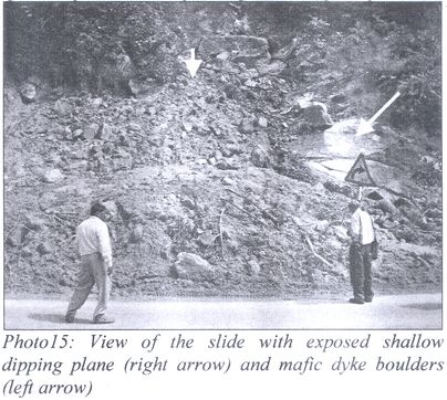
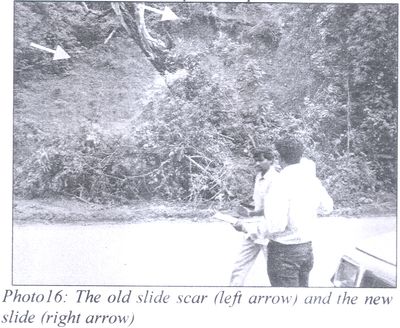
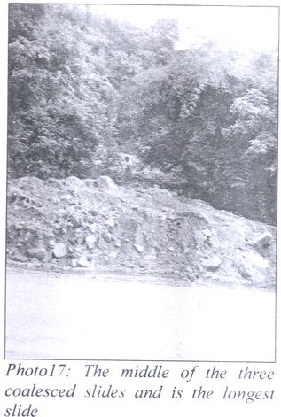
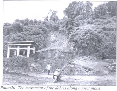
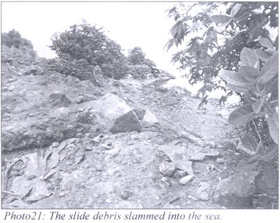
C) Landslides along NH17 between Ankola and Karwar (Photo 15-23) :
i) Landslide 1 :
The slide is located near Agra along NH17 at latitude 14o 46’ 51.2” N and longitude 74o 08’ 47.3”E and falls in toposheet no 48J/1. Approximately 4000 Cu.m of debris material moved down slope and blocked NH17.
Slide morphometry : The slide is a multiple slide (a part of rockslide with planer failure and the other is a shallow rotational debris slide). The overburden/debris towards southeast failed along the contact of the granite and overburden. The debris slide seems to be a base failure along the joint plane. The slide material moved along S25oW direction onto the road and blocked traffic along NH17. The rock type exposed in the area is granite. The length and width of slide is 20m. The slope forming material is weathered blocky granite with two sets of joints.
Cause : The causes of this slide are as follows
- The joint plane has been daylighted due to slope cut for road formation.
- The planer failure occurred along the daylighted joint plane trending N75oE-S75oW dipping 70o southwesterly in granite. The overburden material with granite slipped along this plane.
- High rainfall removed the material along this plane by infiltrated water which also acted as lubricant in reducing the resisting force.
Recommendations :
- The slide debris is to be removed from the slope.
- The material above the exposed granite base should be removed/graded.
- The granite is to be rock bolted as per appropriate spacing after detail study of the site.
ii) Landslide 2 :
The slide is located near Agra along NH17 at latitude 14o 46’ 53.3”N and longitude 74o08’42.9”E and falls in toposheet no 48J/1. Approximately 6000 Cu.m of debris material moved downslope and blocked NH17.
Slide morphometry : The slide had taken place along the contact of a fractured dyke and weathered granite. The slope material (boulders, cobbles of granite and dyke, the overburden soil) moved along a shallow dipping joint plane in granite and the contact plane of granite and dyke. The slide moved in S20oW direction upto the road. With a length of 30m, width 15m and depth 4-5m, the slide can be classified into a complex slide with both rock and debris component.
Causes : The slope failed due to the following causes:
- Blockade of natural stream.
- The weak contact between the weathered granite and weathered dyke.
- The prevailing shallow dip daylighted joint and orientation
- Highly fractured rock mass
- Toe cutting due to slope modification.
Recommendations : As the relative relief of the slope is low with a low original slope angle, the retrogression of the slide is not expected but the lateral widening is pertinent. The concave crown scarp is vulnerable to failure. Hence the following measures are proposed at the site for stabilizing the slope
- The removal of slide debris.
- Grading of the crown scarp by excavation.
- A retaining wall of 2m height is to be constructed at the toe
- Backfilling the slope with stone pitching at 1:1 slope angle.
iii) Landslide 3 :
The landslide along the cut slope of the NH17 occurred on 2nd Oct 2009. The slide is located near Agra along NH17 at latitude 14o 46’ 57.9”N and longitude 74o 08’29.9”E and falls in toposheet no 48J/1. Approximately 50,000 Cu.m of debris moved downslope and blocked NH17.
Slide morphometry : The slide is a multiple debris slide. The debris includes boulders, cobbles and overburden soil and granite. The slide material moved in S25oW direction and blocked the road. Three slides occurred adjacent to each other. The slides from S70oE direction toward N70oW direction along the road have length of 10m, 100m and 30m, width 10m, 20-30m and 15m and depth 2m, 5m and 5m respectively. The slides appear to have occurred independently and coalesced together at their flanks. Old slide scar was observed near the new slides indicating an earlier failure. The widening of the slide is discreet yet it seems continuous. The scarps are vertical to concave into the slope. The slope forming material is lateritic soil and weathered granite. Vegetation on the slope is moderate to sparse.
Causes : The following causes can be attributed to the failure:
- The slope modification for road formation and highly weathered granite material on the slope.
- The presence of old slide with previous unconsolidated slide debris on the slope.
- Sudden increase in the rainfall volume.
Recommendations : The original slope angle is gentle with a very low relief. Lateral widening of the slide is suspected. The slides may coalesce together in future. Hence the following measures are recommended at the site:
- A retaining wall at the toe of the slide as the slide toe lies very near to the road cutting
- Benching of the slope with grading of the crown, as the slope relief is low and slope angle is gentle
- Increasing the land cover with deep rooted plants.
D) Landslide near Karwar port :
iv) Landslide 4 :
The slide is located near Port in Baithkhol at latitude 14o 48’13.3”N and longitude 74o06’49.7”E and falls in toposheet no 48J/1. The slide occurred on 2nd October 2009 in the eastern slope of the N-S trending spur. Approximately 10,000 Cu.m of debris material moved down slope and blocked the road.
Slide morphometry : The slide is a moderate translational debris slide. The debris include boulders, cobbles of weathered granite and soil. The slide with a length of 30-40m, width of 8-10m and depth of 5-6m moved in N75oE direction upto the road. Lateritic soil and weathered granite is the slope forming material. The slide was controlled by the shallow dipping joint plane in granite.
Causes : The causes of the slope failure are:
- The toe cutting of the slope for road.
- The unfavorable joint orientation in granite along which the material slide.
- The blockage of natural stream, no drainage. The slide occurred along the earlier depression/small water outlet.
- High rainfall.
Recommendations : The original slope angle is gentle with a very low relief. As the cause is road cutting the debris is to be removed from site and retaining wall with weep holes at the toe should be provided at the site.
v) Landslide 5 :
The slide is located near Port in Baithkhol at latitude 14o 48’ 16.5” N and longitude 74o06’47.9”E and falls in toposheet no 48J/1. The slide occurred on 2nd October 2009 in the northern slope of the N-S trending spur. Approximately 30,000 Cu.m of debris material moved down slope into the sea and blocked the road.
Slide morphometry : The slide is a multiple and multisource debris slide. The debris consisting of boulders, cobbles of weathered granite and mafic dyke, laterite and lateritic soil. The slide with a length of 200m, width of 100m and depth of 10m moved in N65oE direction into the sea.
Causes : The following causes can be attributed to the failure:
- The slope modification for making the road. The cut slope height is inferred to be >5m at the site with vertical slope angle.
- The presence of moderately dipping joint plane in the granite day lighted toward the free face.
- Immediate cause was the high precipitation
Recommendations : As the original slope angle is gentle with a very low relief, lateral widening of the slide is suspected hence the measures recommended are as follows:
- Retaining wall at the base of the slide after removing the debris.
- Removal of the crown scarp from the left flank of slide.
vi) Landslide 6 :
The slide is located near Port in Baithkhol at latitude 14o48’ 09.8”N and longitude 74o06’50.8” and falls in toposheet no 48J/1. The slide occurred on 2nd October 2009 in the eastern slope of the N-S trending spur. Approximately 15,000 Cu.m of debris material moved down slope and blocked the road.
Slide morphometry : The slide is a complex slide with both rock and debris component. Both rational and translational component caused this slide. The slide material includes boulders and cobbles of weathered granite and lateritic soil and laterite. The slide with a length of 30m, width of 10m and depth of 5m has moved in S50oE direction.
Causes : The causes of the slope failure are:
- The toe cutting of the slope for road.
- The unfavorable joint orientation in granite along which planer failure occurred and the overburden/soil failed towards the northern side.
- High rainfall
Recommendations : The original slope angle is gentle with a very low relief. As the main cause is road cutting the debris is to be removed and retaining wall with weep holes at the toe should be provided.
Few long term strategies to be adopted for Landslide mitigation in this area :
- The landslide hazard zonation of the cut slope along the road cutting along NH 17 in particular and the road network in the hilly areas in general should be carried out to demarcate high vulnerable areas so as to take up preventive measures.
- Assessment of the cut slope stability in the hilly area should be carried out for predicting instability which will be helpful for town planning and developmental activities.
- Landslide awareness programme should be conducted for residents and officials of the hilly region so as to make people aware of the failure patterns, causes and other attributes of slope instability so that they can take precautions at individual level as well as at community level.
ACKNOWLEDGEMENTS
The author is thankful to Shri R.Panduranga, Director, Engineering Geology Division, Op: Karnataka and Goa for his technical guidance and scrutiny of the report. He is thankful to Dr. K. Rajaram, Director (CT), Op: Karnataka and Goa, Geological Survey of India, Bangalore for his guidance and support. He is also thankful to the Dy. Director, DMG, Karwar and his team of geologists for cooperation and combined filed trip to the site. He is also thankful to the members of the Western Ghat Task Force Committee who provided information about the various fields they represent. Thanks are also due for the Additional Dy. Commissioner of Uttar Kannada district, Karwar for providing necessary logistic support for smooth conduct of the field work. Besides the local residents of Kadvad village who provided vital information for interpretation of the data.
|


 Move to Annexure III