 |
Landslides at Karwar, October 2009 : Causes and Remedial Measures |
 |
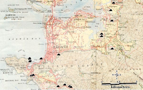
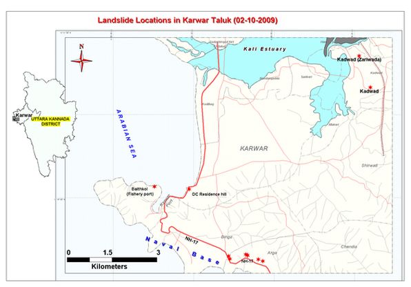
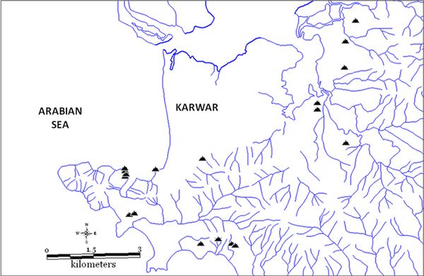
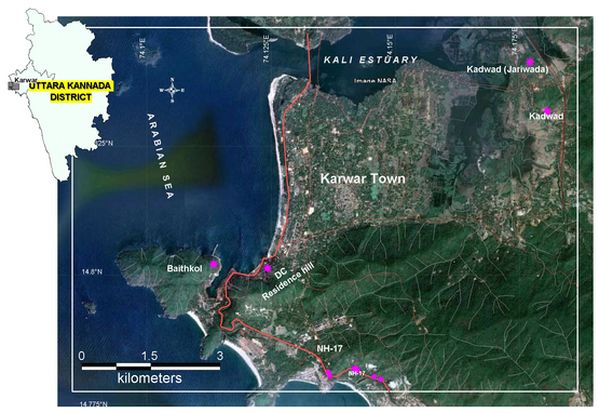
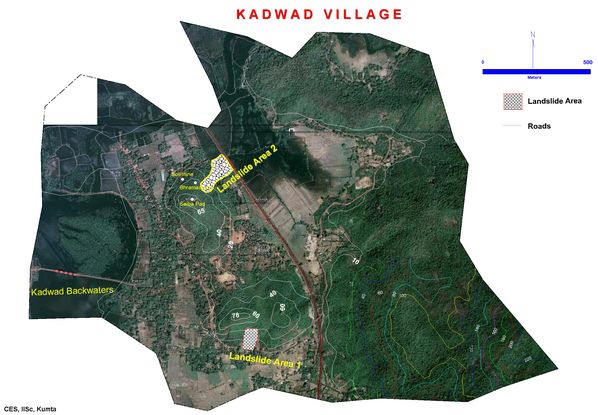
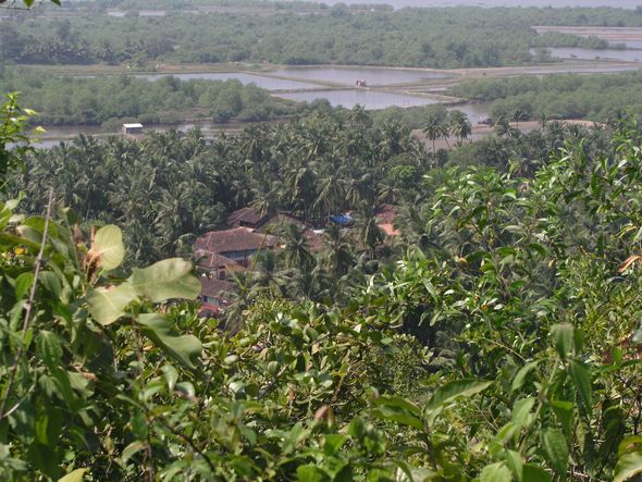
Section 2 : On October 2, 2009, on a day of very heavy rains, the coastal tract of Karwar taluk in Uttara Kannada witnessed a spate of landslides. The most catastrophic landslide took place in the Zariwada (Jarivada) hamlet of Kadwad village, in the outskirts of Karwar town, when a part of a hill overlooking the Kali River estuary, came crashing down at around 4.30 pm, killing 19 people. The people were buried alive and their houses destroyed totally. In the same village part of another hill also slid down, but the people escaped unhurt and their houses were just spared from the fury of nature. There was also a series of other landslides all along the hills to the east of INS Kadamba Naval Base obstructing the NH-17 in several locations. Loosened soils and granite boulders came crashing down the hill slopes, destroying the wall of the Naval Base in many places. As the rain waters flooded parts of the NH, stated to be due to the obstruction created by the compound wall of the Naval Base, some of the local people are reported to have broken the wall to release the flood waters to flow seawards through the Base. Landslides also happened on the steep hill close to the Karwar Port, (on the summit of which Deputy Commissioners’ residence is located). Yet another slide happened in the Baithkol hill overlooking the Fisheries Port. The locations of all major landslides are shown in Figure-2.1.1 (map of coastal Karwar) and (overlaid on Google imagery) in Figure 2.2. Streams of Kali river at the location is given in Figure 2.1.2. The Google Imagery of Kadwad village showing the locations of the two landslides that happened on two different hills the same day is shown in Figure 2.3.1. Lineaments of Karwar is given in Figure 2.3.2. The two landslide areas of Kadwad are shown overlaid on Google Imagery separately as Kadawd-1 (without any casualities) and Kadwad-2 (at Zariwada) where the 19 deaths happened, in Figures-2.4 and 2.5 respectively. Landslides in various pockets of Karwar are listed in Table 2.1.
Table 2.1: Landslide locations visited by the Committee on 14th Oct 09
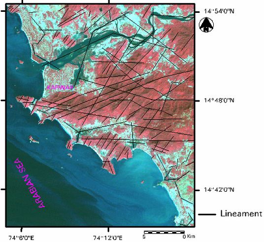
The linear features forming the hill ridges (intrusions such as granite or graniticgneiss, amphibolite, dolerite, etc.) are quite conspicuous and extend to the western margin that some times run along the headlands peaks. The linear trends along the headlands which run shorter distance can be basic dykes or amphibolites which are quite significant and conspicuous all along the central west coast. A lineament passes right across the summit of the hill along the Saiba Pad and another through base of the hill, along south, in east-west direction. A lineament is also found starting close to Landslide Area 1, passes across the railway track in somewhat SW-NE direction). Geomorphologically, the valley area was a paleo-river channel that formerly drained into the Kali River that flows in the north of Zariwada/Kadwad. The shift of the river course might have led to the formation of hills/mounds. Composition of this mound which is mainly of laterite clay further confirms the existence of paleo stream in this region. The paleo-river channel is still connected to the Kali River and the groundwater seepage into the channel increases or decreases rhythmically according to high and low tides in the River. The Konkan Railway track passes through this Zariwada paleo-river valley connecting Karwar town with Goa and other places. The soils of the Uttara Kannada district are basically derivatives of the Dharwad system- the most ancient metamorphic rocks in India- which are rich in iron and manganese. Most of the coastal hills are covered with exposed laterite rocks. These are very unproductive rocks, most of the top-soil already washed off. Peninsular gneiss containing granite occurs towards south of the district. Table 2.2.1 gives the soil texture details. In the zone of accumulation and depletion, debris consists of laterite clay, sand and weathered granite material. Topography and drainage conditions exert considerable influence on the nature of laterite profiles. Drained upland soils are brown-red colour denoting a non-hydrated iron oxide (Fe~O3) in the soil. In middle and lower slopes, soil drainage is poorer than in the upper slope and summit and, hydrated iron oxides mainly goethite (Fe203.H20) and limonite (Fe203.5H20) with reddish brown to brown yellow clay. Lower-slope colluvium is typically brown yellow in colour, as are the better drained soils developed in the alluvium. Table 2.2.2 lists the physical and chemical constituents of the soil.
Table 2.2.1 : Texture of soil samples collected from various locations
Table 2.2.2: Select physico-chemical parameters of soil samples from landslide sites
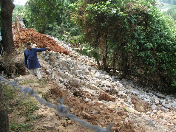
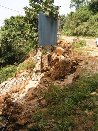
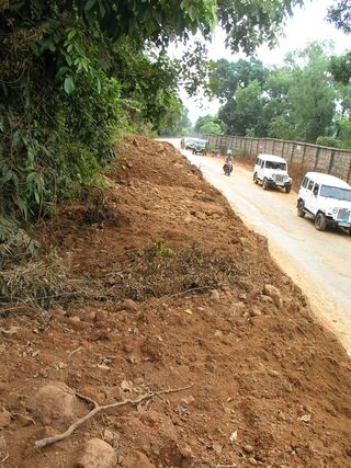
Descriptions of landslides 1. Landslides at National Highway-17 The locations of landslides alongside NH-17 (Figures-2.1 & 2.2) took place in the Arga village, and to the area to the immediate south of Binga village. These locations are along the steep hillsides overlooking the INS Kadamba Naval Base. Many local people suspect that quarrying for for granites, by blasting, along with rainfall could have been a major reason for destabilization of hill slopes. The debris of rock and soil blocked the NH-17 and in many places entered the Naval Base, breaching its compound wall (Figures 2.6-2.8). A landslide of potentially dangerous nature took place from the steep hill (atop which is situated the Deputy Commissioner’s residence- marked as ‘DC residence hill’ in Figures 2.1-2.2). The slide materials, huge granite boulders and soil fell on the NH and even crossed into Arabian Sea across the road. However, no casualties happened as the road was already blocked to traffic due to flooded conditions and landslides.
2. Landslide at Baithkol Baithkol is situated towards the left of a very narrow creek of the Arabian Sea, to the immediate left of the Karwar Port. Baithkol is a promontory at 14.8° N, protruding into the sea. It has created conditions that made Karwar an all weather natural port (Figures 2.1-2.2). Almost triangular in shape, the promontory has its broader base facing the Karwar Port and its acumen jutting into the open sea. Most of this promontory is covered with a steep hill furnished with a good network of natural drainage channels that run in all directions towards the sea. The hill base towards south of fisheries port is a high density human settlement, except towards. However, as the landslide happened towards the north-eastern tip (Figures 2.9-2.10), at the entry point into the creek, free from habitation, the residents were spared from the calamity, or the fisheries port proper affected.
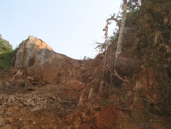
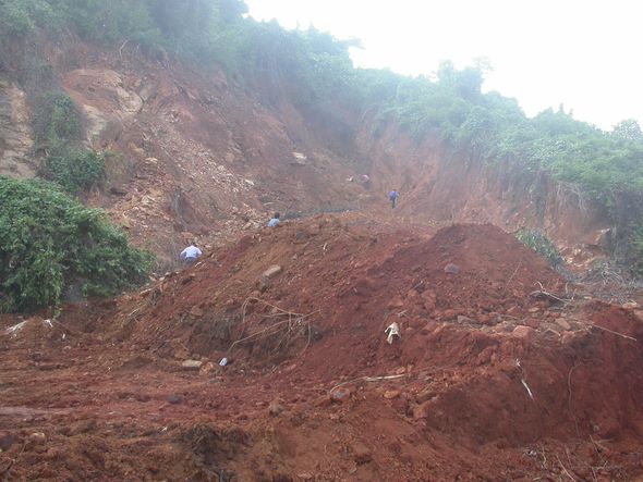
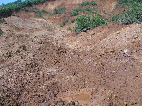
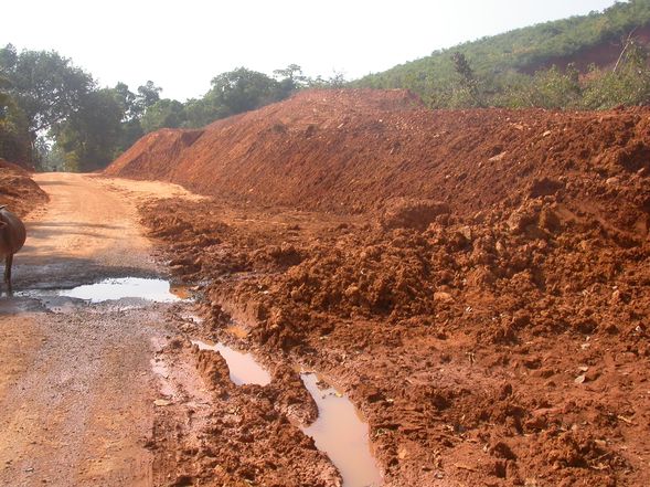
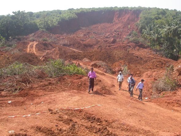
3. Landslides at Kadwad Kadwad village is situated towards the east of Karwar town and south of the Kali River estuary; a large inlet of the estuary could be seen separating the town and Sunkeri village towards its north-east from Kadwad (Figures 2.1-2.2). Towards its north, north-east and west are mangrove swamps, prawn farms, low lying rice fields, marshes and small inlets of the estuary. The two hills, one of 78 m elevation to the south and the other of 65 m towards the north constitute the major landscape features of the village. The zone between lowlands and the hills is densely populated, the houses zoning the normal floodline, and many abutting the slower slopes of the hills. The landslide-1 happened taking away roughly about 100 m wide swathe of a scrub-covered hill. The slide started at about 45 m height in the 78 m hill, towards its southern slope, and the rubble, mostly of soil and mud, moved towards the habitation below, almost crossing the road skirting the hill. The direction of slide was from north-east to south-west. The landslide covered nearly an area of about one hectare (Figures 2.11-2.12). No human casualty happened here, nor any significant loss of property. Preventive measures should be taken forthwith to shelter people and their houses from recurrence of such hazards in the future.
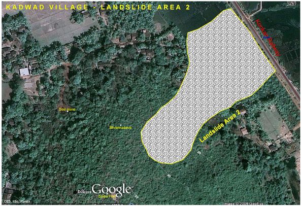
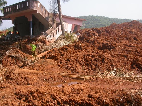
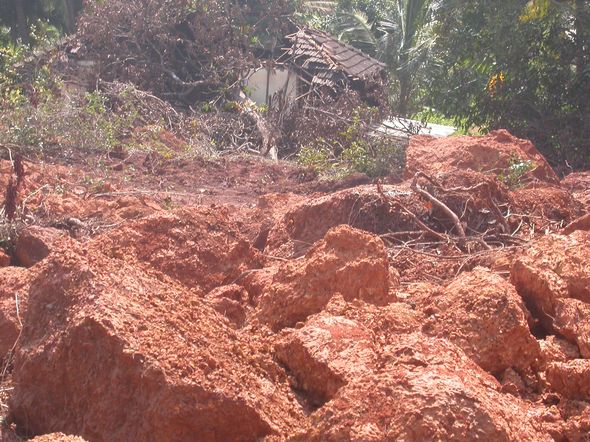
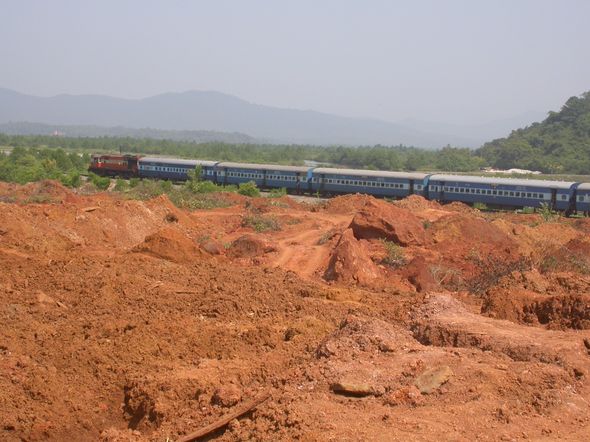
In the landslide-2, the most vicious of all the landslides that ever happened in the history of Uttara Kannada district in which19 people lost their lives. The slide occurred in the Zariwada hamlet towards the north of Kadwad village, on the north-east face of a 65 m hill. The hill ruptured at about 40 m height and the soil, mud and water rushed towards the habitation below at around 4.30 pm on October 2. Horrified on hearing the rumble and seeing the mudslide rushing towards them along with uprooted trees and palms most residents ran for safety along the flooded road. However, unfortunately, eight houses were totally destroyed, with 19 of their inmates buried alive. Eight members of Talekar family lost their lives according to Deccan Chronicle (Oct. 5, 2009). One of the RCC houses (Figure 2.14, the building was constructed on load bearing columns) was carried away from its original location to about 15 m away, where it stood collapsed at the time of our survey. Here also the hill that split is covered with dense scrub with isolated, stunted cashew trees. The rubble of the slide, mainly clayey soil, soft mud, and partially formed, soft laterite from the inside of the hill covered an area of about 1.3 ha. The advance of the slide was checked by the Konkan Railway embankment passing through the mangrove swamps and fields (Figures 2.13-2.17).
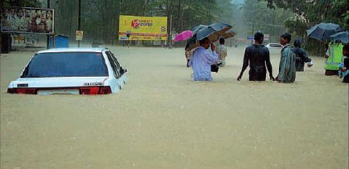
LANDSLIDE RELATED PRESS REPORTS AND OTHER LOCAL ACCOUNTS During our survey also the matter was confirmed by the local people, who also said the compound wall of INS Kadamba collapsed in several places due to the force of the blocked water. The flooding of Karwar city during those October first week days was attributed by locals to poorly engineered drainage system and choking of drainage canals due to inaction of the Municipality. A minor landslide in Canacona in South Goa, that took place at 5.30 am on 2 October, 2009 halted the trains on the Konkan Railway. Railway tracks, south of Karwar were already flooded (http://www.indianews.com/business/2009/1002/224517.htm). Dakshina Kannada had also reported floods and landslides on October, 2. Landslides happened in Venur and Laila of Belthangidi taluk (http://www.daijiworld.comnews)
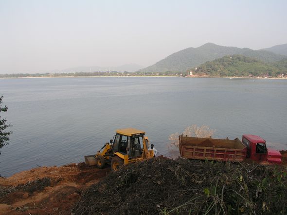
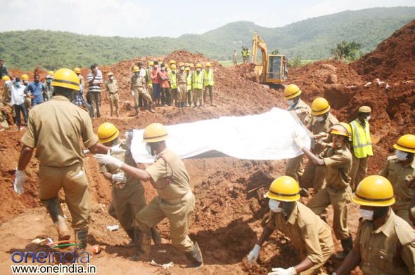
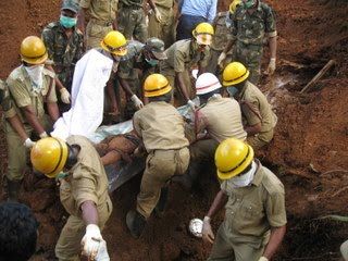
During the meeting convened on landslides in the Deputy Commissioner’s office at Karwar some of the experts concurred with the local representatives that the compound wall of INS Kadamba should not obstruct the drainage of the hills and should make adequate drainage channels at proper intervals. According to Times of India 12, October, 2009 “as the survivors of the landslides are still recovering from the shock of the tragedy, there is a mad race between some contractors to appropriate the soil and rocks” from the landslide areas. The amount of soil in the killer landslide at Kadwad was stated to be six lakh tonnes. The contractors are reported to have sold soil at rates ranging from Rs. 800 to Rs. 950 per truckload. The soil and rocks in the landslide area stated to have been separated by the district administration at the cost of Rs.50 lakh, to facilitate rescue operations, which the contractors considered a boon for them. People resented this move by greedy persons to make money out of the tragedy and urged the district authorities to dispose of the soil through auction so as to recover the money spent on rescue operation. According to the Chief Minister of Karnataka, 18 districts of Karnataka, received between 28th September to 4th October, 2009 abnormally high rainfalls due to low pressure weather system. The departure from normal rainfall in these districts were between 98% high in Chikmagalur to 924% in Bagalkote. The departure for Uttara Kannada district was 435% (http://yeddyurappa.in/news-and-events-report-on-the-losses-and-damages-due-to-floods). The Naval team played important role in recovering the bodies trapped in the debris at Kadwad (http://news.indiaid.com/blog/_archives/2009/10/10/4346356.html). Quoting a member of the Kadwad Village Panchayat a report says: “some illegal miners had moved substantial chunk of mud from the hillock a couple of weeks before the rains started lashing the region. The illegal miners in league with powerful politicians and officials in the district..” (http://www.3dsyndication.comshowarticlerss.aspx?nid). A picture of the relief operations in Kadwad village was contributed by Vinayak Patgar, Kumta (Figure 2.19). Figure 2.20 is of a body being removed from the site.
|
||||||||||||||||||||||||||||||||||||||||||||||||||||||||||||||||||||||||||||||||||||||||||||||||||||||||||||||||||||||||||||||||||||||||||||||||||||||||||||||||||||||||||||||||||||||||||||||||||||||||||||||||||||||||||||||||||||||||||||||||||||||||||||||||||||||||||||||||||||||||||||||||||||||||||||||||||||||||||||||||||||||||||||||||||||||||||||||||||||||||||||||||||||||||||||||||||||||||||||||


 Move to Section 3