 |
Landslides at Karwar, October 2009 : Causes and Remedial Measures |
 |
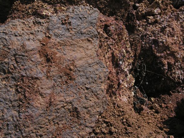
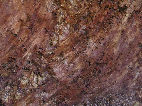
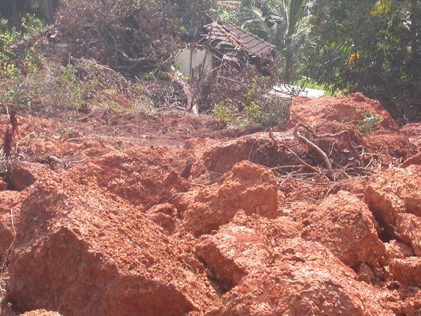
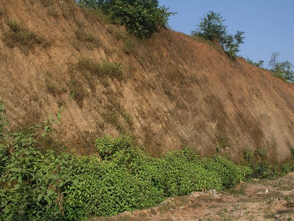
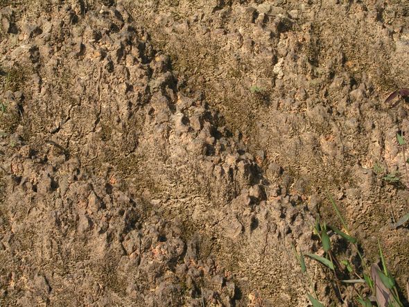
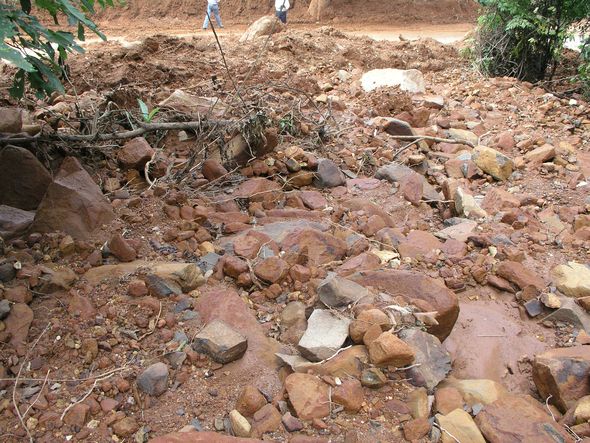
SECTION 4 : A graphic report of Kadwad landslides is found in Geo Karnataka (October 19, 2009), along with a plausible explanation. Zariwada as the name suggests is a low-lying valley region characterized by seepage of ground water. Geomorphologically, the valley area can be recognized as an old stream (paleo-river) channel that formerly drained into the Kali River that flows in the north of Zariwada. The paleo-river channel is still connected to the Kali River and the groundwater seepage into the channel increases or decreases rhythmically according to high and low tides in the River. Zariwada colony of houses was located beside a huge clayey-laterite hill. The hill consists largely of reddish clays and was topped by thin cap of laterite. Granitic material underlies the clayey hill as can be seen in some cuttings. The clayey material from the hill was in demand for using as filler material in construction sites. The removal of clays from the eastern flank of the hill had created a vertical scarp on the eastern flank of the hill that increased the instability of the hill flank. On 2-10-2009, due to rains, people in the Zariwada colony were inside their houses Around 4.15pm, the eastern scarp flank of the Zariwada suddenly gave up and ruptured with a thud of sound. The massive quantity of loose clayey material abruptly rolled down the gradient and settled on the 9 houses burying the 19 inmates alive. The whole process of landslide ended by 4.30 pm. On 3-10-2009, early morning about 3.30 am, another clayey hill on the western side of Zariwada also collapsed blocking the road leading to Kadwad. However there were no human casualties since the houses were located at a distance from the affected hills. It is reported that similar landslides had occurred in the Kadwada area, during the year 1959. Mechanism of landslide (as given in Geo Karnataka, October 19, 2009): The laterite capped clayey material in the Zariwada hill were densely soaked in water due to persistent rains in the area. The basic character of the clays allows them to absorb water easily into their intergranular pore spaces, but the inherent nature of poor permeability prevent them from discharging the excess water held in the pore-spaces. Added to this, the seepage of water into the Zariwada paleo-river valley from the Kali River backwaters render the area excessively saturated with water, preventing any discharge from the equally saturated clayey hills of Zariwada. The excessive pore-water pressure in the clayey material of Zariwada hill when crossed the optimum limit led to disruption of unstable scarp slope leading to the massive landslide. The massive landslide brought down huge quantity of clayey soils from the hill with landslide collapsed area measuring about 90 m wide, 150m long and 10 to 30 m high along the eastern flank of the Zariwada hill. The derived huge quantity of loose material covered the bottom of the hill where there were several houses with people inside. The sudden fall of the massive material that lasted barely 15 minutes between 4.15 to 4.30 pm on 2-10-2009 buried alive the people inside the doomed houses. The direction of flow of the fallen clayey soil material was blocked by the Railway track in the east and was diverted towards north. One house was dragged northwards for some 10 meters along with the moving material derived from the landslide. Lesson from the Zariwada disaster is that clayey hills beside river zones in Coastal Karnataka are susceptible for sudden landslides during the rainy season and the people should be prevented from constructing houses or living near the susceptible clayey hills located near the rivers. Note on laterites and other rocks of Karwar landslides Laterites and laterite genesis are highly complex issues (Ollier and Sheth, 2008). There are conflicting theories on laterite formation and it is not in the purview of this report to dwell on those. The Zariwada hill surface has a thin interrupted mantle of highly weathered laterite blocks (Figure 4.1). On the contrary such hard, mature, eroded and honey-combed laterite structure does not exist in the interior of the hill, which is a mass of soil, deep-yellowish red to dark red or reddish brown clayey loam type. Soft laterite, is seen in the interior as shown in the Figures 4.2-4.3. The reason for immaturity of laterite could be the lack of erosion and weathering. There is excessive wetting during the monsoons but probably not followed by dryness because of the fact the Zariwada hill is within the backwater zone of Kali River, and probably in a palaeo river valley, as reported to in Geo Karnataka. The name Zariwada itself suggests a low lying valley, characterized by seepage of ground water. Water table is very high in the village and even during summer months well water level is within few meters. Immaturity of the laterite could be precisely due to this factor, as the clay fraction is not washed out of it nor the buried prototype subjected to drying effect of the prolonged post-monsoon period. This situation is quite contrary to the laterite of southern taluks like Kumta, Honavar or Bhatkal where the rain washed laterite, is exposed to months of dryness. On exposure, with the leaching away of clay and soil and soluble fractions of minerals the laterite presents typical honey comb appearance and vermiform tubules. The landslide chances of lateritic hills of southern coast (Kumta to Bhatkal) are slim because of the hardness of the exposed surface. A road cutting in Kumta taluk shows such hardened surface with least chances of landslide (figures 4.4-4.5)unlike the granite-soil complex of Karwar hills along the NH-17 where several slides have happened. Note that the picture of road cutting is in contrast to the collapsed hillside of same NH-17 in the Arga hill of Karwar (Figure 4.6). Granite and other related rocks derived from Peninsular gneisses are the predominant rock types in Karwar, and could be seen all along the coastal hills.
Increase in soil erosion In the recent years Karwar coast has experienced severe soil erosion due to more of anthropogenic factors. During 1989-2000 period (11 years) the erosion of land was estimated to be 174.4 hectares, whereas during 2000-2003 (just three years) the erosion of land increased by almost one and half times. This sudden rise in erosion may be due to the enhanced human interference along the coast owing to urbanisation, harbour development, naval base establishment, desiltation in the bays, estuaries and creeks; effects of dams constructed along Kali river, sand mining from beach ridge-dune system and river beds (Hanamgond and Mitra, 2007). Lineaments: Karwar Lineament studies have become an important step in analyzing the structural and tectonic aspects of an area. A lineament is a regional scale linear or curvilinear feature, pattern or change in pattern that can be identified in a data set and attributed to a geologic formation or structure. Lineaments may represent fractures, faults, joint sets, shear zones etc. Karnataka State has thousands of lineaments of varying length of which 69 lineaments are over 100 km long. In general, it is believed that these lineaments might have formed due to tectonic activities, plate movement etc. some of the major lineaments correspond to faults. Lineament zones often yield valuable minerals, oil etc. Lineaments representing fractures and faults are in general classified as high ground-water potential zones. Generally, it is believed that seismicity is also associated with major lineaments (Raj, 1994). Using remote sensing data Hanamgond and Mitra (2007) identified 131 lineaments in coastal Karwar. The presence of highly folded granitic gneiss The intensive igneous activity by way of dyke intrusions, presence of ptygmatic, criss-cross pegmatite intrusions and highly folded granitic gneiss (all forming lineaments) are evidences of high shear along this stretch. Based on the lineaments study and the known tectonic trends identified by earlier workers on regional scale, it has been opined that the Karwar coast is structurally controlled and the tectonic processes control the lineament pattern (Nayak, 1993; Hanamgond and Mitra, 2003;).
|

 Move to Section 5