| Previous Session | Paper 1 | Paper 2 | Paper 3 | Paper 4 | Paper 5 | Paper 6 | Paper 7 | Paper 8 | Paper 9 | Paper 10 | Paper 11 | Paper 12 | Paper 13 | Paper 14 | Paper 15 | Paper 16 | Paper 17 | Paper 18 | Paper 19 | Next Session |
SESSION-16 : College Students
PAPER-9: LAKES Features and Remedies
Pradhyumna C.S.
CONTENTS-
Abstract
Introduction
Lakes in Bangalore
Lake and its Water Shed
Lake Processes
Case Studies
Conclusion
| Abstract | up | previous | next | last |
Lakes are more complex and fragile ecosystems than rivers. Because of their importance, beauty, religious and cultural significance and their relative vulnerability to degradation, lakes and reservoirs require more attention than is applied generally to rivers and stream basins.
There are many different types of lakes and reservoirs and they serve many functions and purposes. Some lakes are ephemeral such as flood plain lakes of large rivers. Others may be located in dry regions and are saline like the Aral sea in Asia or the Great salt lake in America. Small salt water lakes in coastal zones are essential for certain fisheries. Some lakes are recharged almost totally from the ground water inflow, while others, like lake Chad in Africa are small lakes in flood plains or delta areas in Asia, and recharge ground water supplies depending on the size, depth, climate and flow regime, lakes differ in their vulnerability to pollution.
The paper provides a brief introduction about lakes across the world, lakes in Bangalore, benefits of restoration, lake and its watershed, lake morphometry, lake processes, the classical lake succession sequence, point and non-point sources of pollution, effects of sewage discharge into a clean lake, measures for restoration of a polluted lake and technology options for treating the point and non-point sources of pollution. The paper concludes by giving a probable scheme for restoration and development of lakes in cities such as Bangalore.
| Introduction | up | previous | next | last |
What is a Lake? An inland body of standing water or it is defined as an aggregate of water bodies, created by the natural phenomenon or man made. The lakes formed due to natural phenomenon are 10,000 or 1,20,000 old, as glaciers moved across, the large area of North America and Europe Asia (Great Ice Age). Lakes also originated in other natural events, such as earthquake and volcanoes, Lake Baikal in Siberia and Lake Tanganyika in equatorial Africa. Gradual forces such as the corrosive movements of rivers can also create lakes, and the cutting off of meander channels, form Oxbow lake but they are seldom permanent.
| Lakes in Bangalore | up | previous | next | last |
Bangalore had a large number of lakes (262 lakes in the year 1960), which ensured a high ground water table and also a cool climate in the city. Due to rapid urbanisation and a high rate of population growth, there was a high demand for land, for housing and other amenities which had resulted in breaching of several lakes and conversion of open spaces into buildings, for example, the Bangalore city bus stand was erstwhile Dharmambudhikere (lake), The Karnataka Golf Association (KGA) located off the airport road was erstwhile Challaghattakere. The number of lakes still surviving has been drastically reduced to 114. Discharge of sewage, other waste water and dumping of solid waste into storm water drains pollute many of the existing lakes.
Benefits of Restoration of Lakes.
• Rain water harvesting and Groundwater recharge
• Reduction of Groundwater Pollution
• Reduced Mosquito menace
• Fishing, boating, swimming and other recreational purposes.
• Rain water harvesting and Groundwater recharge-
Table 1: Water Runoff Affected by Land cover
Type of Land cover |
Runoff in % |
Groundwater Infiltration in % |
Forest |
10-20 |
80-90 |
Agriculture |
50-60 |
50-40 |
Residential |
40-50 |
60-50 |
Urban |
90-100 |
10-0 |
Runoff is reduced on land with vegetative cover and increased on land with impermeable surfaces such as roads, parking lots and roofs.
The fresh rainwater gets polluted due to flow of sewage and sullage in all the storm water drains. Due to steep gradient available, entire rain water except the water stored in the lakes would flow out of the city within a short period of 5-6 hours. The water impounded in the lakes will enhance ground water recharge due to the pressure of standing water column on the lake bed.
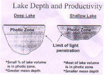
Lake Depth and Productivity
Photic zone : That area of a lake having sufficient light to support photosynthesis.
Aphotic zone : That area of the lake too dark to support photosynthesis.
Hydrologic Cycle
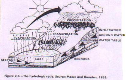
The circulation of water from atmosphere to earth and back to the atmosphere is a process that is powered by the sun. About three fourths of the precipitation that falls on land is returned to atmosphere as vapour through evaporation and transpiration from terrestrial plants and emergent floating aquatic plants. The remaining precipitation either is stored in Ice caps, or drains directly off the land into surface water systems (such as streams, rivers, lakes or oceans) from which it eventually evaporates, or infiltrates the soil and underlying rock layers and enters the ground water system. The ground water enters the lake and streams through underwater seeps, springs, or surface channels and then evaporates into the atmosphere.
Hydraulic Residence Time (HRT)
The average time required to completely renew the water volume of a lake is called the hydraulic residence time .
Lake Morphometry (Lake Physical Dimensions)
Surface area A 0 : (acres or hectares) Important for managing lakes.
Maximum depth Zmax: (feet or meters), The location where water is deepest influences stratification and the proportion of water in which algae can grow.
Mean depth Zm : (meters or feet) The average depth of the lake calculated by dividing the volume by the surface area.
Volume V: (cumeters or cufeet) Total amount of water in the lake influence the dilution of inflowing nutrients, affects HRT.
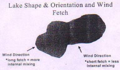
Fetch: (meters or feet) Longest uninterrupted distance over which the wind blows across the Lake varies with the wind direction, and affects wave height and vertical mixing of water. A lake with a very long wind fetch may be more turbid than a lake of the same size where fetch is shorter.
Shoreline Length L units = meters (m) or feet (ft): the total length of the shoreline encompassing the lake (lake circumference). This distance represents the total amount of Lake Front available for activities such as homes and for lake edge effects (shoreline erosion, littoral habitat, etc,).
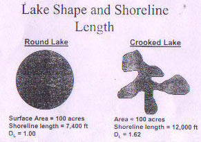
Shoreline Development (D L ); ( unitless) Measure of roundness of lake, is the ratio of the length of the shoreline to the circumference of a circle whose area is equal to that of the lake.
| Lake Processes | up | previous | next | last |
• Lake stratification and process
• Photosynthesis and respiration
• Aquatic Plant productivity
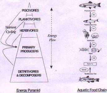
• Food web structure, Energy flow and nutrient cycling
• Eutrophication
Stratification Process: in which several horizontal water layers of different densities form in some lakes. The thermal properties of lakes and the annual circulation events probably have greater influence on lake biology and chemistry than any other factor. Lake water absorbs heat energy directly from the sunlight and additional heat from the air. The mixing action of wind helps distribute this heat through out a lake's surface water.
The well mixed and uniformly warm surface waters are called the epilimnion, while the uniformly cold, unmixed bottom waters are called the hypolimnion.
The two layers are separated by a zone of rapidly changing temperature and density called metalimnion - that layer of water where the temperature changes by more than one degree Celsius for each meter of water depth. In effect, the metalimnion acts as a lid separating the epilimnion from the hypolimnion during stratification.
Another term, the thermocline, defines that particular depth within the metalimnion where the rate of change in temperature is greatest.
Photosynthesis and respiration
Light energy from the sun fuels the lake ecosystem. As the light strikes the surface, a large proportion is reflected back and never enters the water, of the remaining light some is scattered by suspended particles, some is absorbed by the dissolved colour and organic materials in the water, and finally, some is used by algae and macrophytes (rooted plants) in photosynthesis to convert the light energy to chemical energy. In photosynthesis, aquatic plants and algae use the energy from the sunlight, carbon dioxide, and water to produce sugar, water, and molecular oxygen. Plant cells then convert the sugar, along with certain inorganic elements such as phosphorus, nitrogen, and sulphur, into organic compounds such as proteins and carbohydrates, and fats. The amount of plant material produced and remaining in the system is called primary production.
Aquatic plant productivity
Algae: are photosynthetic organisms that form the base of the aquatic food chain and are grazed upon by zooplankton and herbivorous fish. Microscopic algae that have little or no resistance to water currents and live suspended in the water are called phytoplankton . Other lake or stream algae may be found primarily attached to substrates in the water such as piers, rocks, and rooted plants. These attached algae are known as periphyton. Algae are classified according to colour: as green algae, blue green algae, golden algae, and so on. The colours refer to the most visible pigment in the cells chlorophyll in green algae, carotene, and phycobilins in blue green algae and abundant carotene in golden algae.
Zooplankton: microscopic animals that float freely in lake water, graze on detritus particles, bacteria, other zooplankton, and algae, and may be consumed by fish. Fresh water lakes contain a richly diverse array of microscopic and macroscopic animals in the water columns that float, drift, or swim weakly (i.e. they are at the mercy of currents). These animals are collectively known as zooplanktons. The most significant group of fresh water zooplanktons is the cladocerans , copepods, protozoa, and rotifers.
Macrophytes: are vascular plants i.e. they have conducting cells to transport nutrients and the liquid through their stems. Most rooted macrophytes obtain their nutrients from the bottom sediments rather than the water and are restricted to the shallow littoral water. In other words, the littoral zone defines the area where there is enough light near the sediments to support degradation of organic matter. The rooted macrophytes make littoral zone the most productive and important aquatic habitat in fresh water lakes.
Food web structure
In lakes plant production usually forms the organic matter base of the lake's food web. Most lakes require a reliable level of algal and macrophyte production to maintain productive food webs. Some of the organic matter produced photo synthetically by the lake's primary producers (algae and macrophytes) is consumed by the herbivores (grazers) that range from tiny zooplankton to snails to grazing minnows. Herbivores, such as the zooplankton are fed on by the planktivores (including predatory zooplankton, aquatic plant insects and planktivores fish) that, in turn provide food source for the higher level consumers such as piscivores (fish eating) fish (bass, walleye, pike) and fish eating birds ( kingfishers, herons, ospreys, eagles). This general progression of feeding levels from primary producers, to herbivores, to planktivores to increasingly larger predators, constitutes a food chain.
The energy flow begins with light energy from the sun, which is converted by green plant photosynthesis in to the chemical energy represented by the organic matter produced by plants. Each subsequent consumer (herbivore, planktivore, piscivore) transfers only a fraction (usually about 10 to 20 percent) of the energy received on to the next trophic level. Because of this inefficient energy transfer, a few large game fish depend on a large supply of smaller herbivores, which depends on a successively much larger base of photosynthetic production by phytoplankton and other aquatic plants. Finally, by constantly producing wastes and eventually dying, all these organisms nourish detritivores (detritus eating organisms), bacteria, and fungi, which derive their energy by decomposing organic matter. Organic matter decomposition recycles the nutrients required to produce plants. This nutrient regeneration occurs at virtually every level of the food web, and only a small fraction of the organic matter produced ultimately accumulates as permanent bottom sediment.
Eutrophication: is defined as the excessive addition of inorganic nutrients, organic matter, silt to lakes, there by increasing biological productivity.
The classical lake succession sequence:
Oligotrophy: lack of plant nutrients keeps productivity low: lake contains oxygen at all depths, clear water.
Mesotrophy: moderate plant productivity: hypolimnion may lack oxygen in summer: moderately clear water: warm water fisheries only.
Eutrophy: contains excess nutrients: blue green algae dominate during summer: algal scum are probable at times; hypolimnion lacks oxygen in summer; poor transparency: rooted macrophyte problems may be evident.
Hypereutrophy: algal scum dominate in summer; few macrophytes no oxygen in hypolimnion; fish kills in summer and winter.
Lakes in Bangalore:The topography of Bangalore comprises of hills and valleys. The elevation varies from 830 to 930m; entire area is divided into gradually sloping hills and valleys. Each valley at the ridge top give birth to small streams, such stream fall into major valley thus forming three major stream systems viz., Hebbal chain of streams, Koramangala- Challaghatta chain of streams and Vrushabavathi chain of streams.
As the area is part of semi-arid tropics, the forefathers of the city wisely used streams between ridges and valleys and created man made lakes by damming the streams at appropriate places. Thus the lakes are in the form of chains of reservoirs in each of the above mentioned valley systems. The lake harvests rain water from its catchments. When completely filled, surplus water further spills into down stream contributing water to be impounded into the next lake in the chain. In the past people in the area used water from lakes for irrigating agricultural crops, the dug wells and steeped wells provided much needed drinking water to the city. Large number of lakes ensured a very rich under ground water source. Thus flourished a healthy and prosperous civilization in the midst of calm and a cool locality.
The population of Bangalore which was nearly 1.59 lakhs in 1901 and 4.07 lakhs in 1941 started growing by leaps and bounds ultimately reaching an estimated population of 5.5 millions in the year 2001. The capacity of the lakes to harvest water from precipitation is around 970 mm per annum on an average from an area of 593 sq kilometers, which constitutes 76.50% of potable water supply to Bangalore city. It is estimated that nearly 1.25 lakh bore wells (tube wells) exist in the Bangalore city. The survival of these tube wells depends on much needed recharge of underground water. The existing lakes with their water spread area of nearly 1500 sq.km can recharge the ground water to an extent of 41975 million litres per annum.
As per the analysis carried out by forest department, the common problems faced by lakes are
• encroachment
• discharge of untreated sewerage in to the lakes since decades
• drying of lake beds and its misuse
• lack of adequate staff for protection
• lack of funds for lakes development
The result of brief studies conducted about the water status of the lakes (conducted by the forest department) are as follows.
No. of Lakes
• Sewage water is flowing in to lakes - 60
• Breached/dried lakes - 28
• Fresh water lakes - 22
• Fully encroached - 04
Total 114
The sources of pollution of a lake can be from point and non point sources. The non point sources of pollution depends essentially on the water shed area of the lake.
The lake and its watershedThe extent of area of land from which the rain and surface water drains flow towards the lake is called as watershed area or catchment area, or drainage basin of the lake. The clean or polluted status of the lake entirely depends on the status of its watershed area. If the watershed area is free from discharge of sewage in open drains and the solid wastes are not heaped on the land surface and are collected and disposed efficiently, the rain water runoff from the water shed will contain no organic matter and nutrients in large quantities. A highly polluted lake is an indicator of unsanitary conditions prevailing in the watershed area of the lake.
Point sources of pollution: The point sources of pollution include various streams containing sewage and other industrial effluents discharged into the lake.
Non point sources of pollution: The major non point sources of an urban area in the Indian cities include waste products dumped on land with in the city such as commercial areas of different classifications vegetable markets disposing perishable wastes containing high amounts of phosphorus and nitrogen and organic matter, slaughter houses disposing waste meat, skin liquid wastes containing animal blood, urine, and fecal matter, hospital wastes, waste food products from hotels, restaurants, marriage halls, road side vendors, sewage and sullage from slum areas.
Effects of sewage discharge in to a clean lake: When domestic sewage or a similar pollutant is discharged a succession of changes takes place in the lake water. The suspended organic solids get dispersed in the water, the water becomes turbid, heavier solids settle down to the bottom of the lake, dissolved oxygen of the lake water is depleted or exhausted totally due to the BOD of the sewage, and scavenging organisms digest the organic matter. The nutritional elements nitrogen, carbon, and phosphorous present in the sewage and sewage solids deposited in the lake undergo their natural biological cycles of digestion. Microbial population breakdown the organic solids and release the nutrients to the lake sediments and the lake water. The nutrients released in the water induce the growth of algae and other aquatic weeds. The dead weeds sink to the bottom of lake and build up nutrient rich organic sludge and sediments.
These sediments become a source of nutrients to the lake water and accelerate the eutrophication process. A polluted lake continues to remain under eutrophic state even after stopping the point sources of pollution due to non point sources and release of nutrients in the lake. The nutrients dumped in to the lake namely nitrogen and phosphorus and the organic matters are the root cause for the profuse growth of aquatic weeds and algal blooms leading to eutrophication of lakes.
MeasureS For Restoration Of A Polluted Lake
The measures for prevention and control of pollution involves two major steps.
• Water shed improvements to stop point sources of pollution and non point sources of pollution.
• Removal of nutrient rich sediments from the lake bottom.
The Water Shed Improvements
Controlling point sources of pollution: the water shed improvements for controlling point sources of pollution will include providing sanitary sewers for transmitting the domestic sewage and industrial waste water if any to the sewage treatment plant (STP), instead of allowing the sewage and waste water to flow in open storm water drains and construction of sewage treatment plant to prevent point sources of pollution.
The water shed management for an urban lake restoration will involve the following.
• Stopping the bulk discharges of sewage and industrial effluents in open drains
• Laying underground sewers in the unsewered areas in the city.
• Repairing damaged sewers and man holes in the sewered areas.
• Linking the lateral sewers terminated in drains to trunk sewers.
• Improving the solid waste collection and disposal system.
• Construction of sewage treatment plants.
Controlling the non-point sources of pollution: is a difficult task. The first step in this direction is the collection of solid waste collection system has to be made efficient. Septage systems like septic tanks and soak pits have to be changed over to under ground sanitary sewers, which may not be possible in un-sewered areas of the city.
Removal of nutrient rich sediments to control sediment release of phosphorus:
Urban lakes which were used for disposal of untreated municipal sewage and other waste water for many years will have deposits of sewage solids and sludge containing organic matter and nitrogen and phosphorus. To prevent sediment release of phosphorus it is necessary to excavate and remove the organic sediment layer. The removed bottom sediments can be used as manure for agriculture, whereas, the transporation of silt and sediments is very expensive. To some extent the excavated sediments can be used for widening the bund, forming the ring bunds: in which case it is necessary to cover these nutrient rich sediments with earth cappings to prevent leaching of nutrients to the lake water. Dredging has to be done to restore deep lakes.
Dredging
To remove the nutrient-rich sediment is, of course, the most logical solution to internal loading (Bjork 1988). A dredger moves the sediment to artificial basins where the particles are allowed to sink. The water is either returned directly to the lake or when the phosphorus concentration has been reduced with aluminum sulphate (Al (SO 4 ) 2 ) or iron chloride (FeCl 3 ). Phosphorus binds chemically to metals, such as aluminum (Al) and iron (Fe), and the resulting phosphorus-metal complex precipitates and can be removed mechanically. This method is also commonly used in sewage treatment plants. Due to technical and economic reasons, dredging is suitable mainly in small, shallow lakes and ponds. Or the the following method can also be followed.
The Riplox method'
The aim of this method is to reduce the internal loading of phosphorus by oxidising the sediment surface, causing phosphate to precipitate in metal complexes. By pumping calcium nitrate (Ca(NO 3 ) 2 ) and adding iron chloride (FeCl 3 ) into the sediment, oxygen and iron (Fe) concentrations, respectively, are increased. The pH is stabilised with the addition of calcium hydroxide (Ca(OH) 2 ). At a suitable pH, denitrifying bacteria will transfer the nitrate in (Ca(NO 3 ) 2 ) to N 2 gas, which is released to the atmosphere. If all these steps work, a lid' is created, preventing the release of phosphorus from the sediment into the water.
Technology options for treating the point sources of pollution and non-point sources of pollution.
| Case Studies | up | previous | next | last |
Case Study 1 : Riverside, California's constructed wetlands experience
Wetlands are one of the most biologically productive ecosystems in the United States, yet since colonisation, half of them have been destroyed by humans. Each year, between 101,000 and 200,000 ha (250,000 and 500,000 acres) of wetlands have been lost to agricultural, industrial, and infrastructure development. In California, nearly 90% of the states' wetlands are gone. Natural wetlands, lost to development, are not easily recovered.
The city of Riverside, California., took a step toward reversing the loss of wetlands in March 1995 when it completed construction of the Hidden Valley Wetlands Enhancement Project, which established five new ponds (9.3 ha, 23 ac) and improved operation of eight existing ponds (15 ha, or 37 ac)
The Riverside regional water quality control plant has a design capacity of 151,400 m 3 /d (40mgd) and full nitrification capabilities built into the biological treatment process. Prior to the project, tertiary filtered effluent was discharged to the Santa Ana River via a 1.6-km (1-mi) effluent channel.
In 1991, the California Regional Water Quality Control Board in the Santa Ana region adopted a revised total inorganic nitrogen (TIN) wasteload allocation to protect groundwater basins designated for domestic supply. This modification was reflected in the city's 1992 National Pollutant Discharge Elimination System (NPDES) permit, which incorporated a TIN limit of 13mg/L for effluent up to 140,000 m 3 /d (38 mgd). Flow in excess of 140,000 m 3 /d must comply with a TIN discharge limit of 10 mg/L, which is comparable to the California primary drinking water standard.
Questions about the plants' ability to remove additional nitrogen from wastewater were raised in the permit.
To determine the fate of nitrogen in Hidden Valley, researchers at the University of California at Riverside examined four open-water wetland ponds. Even though the wetland system contained emergent plant growth and was not optimised for nitrogen removal, the study found that it reduced nitrogen to levels required by the facility's NPDES permit. The city incorporated the wetlands into its nitrogen management plan and, with its implementation, received the added benefits of
• restoring or developing a high-quality riparian habitat for native and transient migratory wildlife species;
• providing a reliable reclaimed water supply for the wetland ecosystem;
• recharging groundwater basins with highly polished tertiary filtered effluent;
• providing a base for research and development of natural treatment processes; and
• mitigating non-native vegetation and protecting wildlife with the coordination of local agency resources.
Case Study 2 : Natural Systems Setup at the Rideau Valley Construction Authority Workshop ( Ontario, Canada)
A field-scale research project recently conducted at the Rideau Valley Conservation Authority Workshop (Kars, Ontario, Canada) demonstrated that natural systems could treat wastewater effectively for small users in a variable, cold climate. The simple, passive system tolerated variable wastewater strength and flows and treated a large group of contaminants efficiently without power, chemicals, or complex operation and maintenance.
In this project, researchers limited themselves to natural systems, which are simple to operate and maintain because they depend primarily on their natural components and require no external input of energy or materials to maintain major treatment processes. After evaluating available treatment technologies based on land restrictions, exposure risks, aesthetics, and other factors, they chose five alternatives:
• A sphagnum peat moss filter.
• A sand filter
• A subsurface-flow constructed wetland.
• A peat filter combined with a wetland cell
• A sand filter combined with a wetland cell.
Overall, this research demonstrated that natural systems could provide practical treatment for individual or communal applications in colder, variable climates. The choice of treatment configuration will depend on site-specific requirements and discharge criteria. The sand filter, for example, can provide a high level of treatment for all researched parameters except nitrate-nitrogen. The peat filter provides more consistent bacteria removal and nitrogen reduction than the sand filter, but less effective phosphorus reduction. The wetland partially treats all parameters and provides a scaleable method of effluent polishing that could be adjusted to achieve the treatment objectives, such as improving nitrate-nitrogen reduction through denitrification.
Case Study 3 : Probable Scheme for our condtions
Treatment of Point sources of pollution for system of lakes
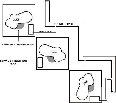
The figure shows the proposed scenario for a city like Bangalore, which has interlinked lakes. Diversion of sewage into these lakes, say for example:- 3mld of sewage being diverted into one lake (or as per flow measurements, flood discharge conditions) through sewage treatment plant (extended aeration mode along with a constructed wetland). The benefits of proposing such a thing is as follows.
• Effective rain water harvesting
• Effective treatment of sewage (because the quantum of sewage is less)
• Operation and Maintenance of the STP is easy and the cost is less.
• Since the quantum of sewage is less, the adoption of technologies such as sewage treatment by Earthworms African Night Crawlers for treatment of secondary effluents.
• Conserving of electricity by utilising solar energy.
• Recreational park or medicinal plants such as Dhanavanthri Vana.
| Conclusion | up | previous | next | last |
It is quite clear that ecological balance is well established if the lakes are in oligotrophic conditions. Hence the necessity to restore the lakes becomes paramount. Regarding controlling of point sources and non-point sources of pollution. It would be better if we are able to advocate technologies such as constructed wetland, sewage treatment using earthworms or sewage treatment as used in Rideau valley workshop in Canada. The bottom-line is we just cannot afford a sewage treatment plant as, we neither can meet power requirements (required by various electromechanical equipments such as airblowers, sewage and sludge pumps) nor can we meet the exorbitant operation and maintenance costs involved.
| Address: | up | previous |
#44, Vinayakanagar,
3 rd main, 5 th cross,
B.S.K 1 st stage,
Bangalore 560050,
Karnataka, India.
Phone: 91-080-679835.
E-Mail: pradhyumna2000@yahoo.co.in