|
8.0 |
Krishna River |
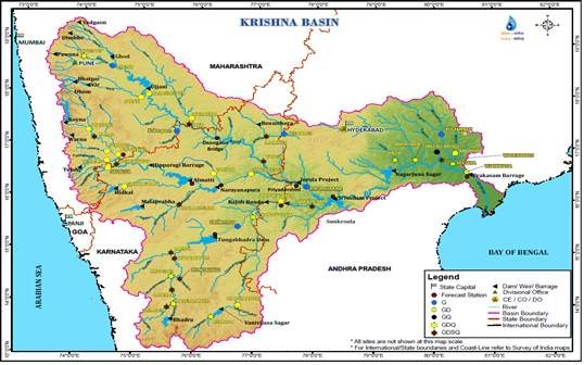
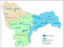
Brief Description: Krishna is second largest river in peninsular India, rises in the Western Ghats at an altitude of 1337 m. near Mahabaleshwar in Maharashtra State, about 64 km from the Arabian Sea (http://nihroorkee.gov.in/). On the north, the basin is bounded by the range separating it from the Godavari basin, on the south and east by the Eastern Ghats and on the west by the Western Ghats. It flows across the whole width of the peninsula, from west to east, for a length of about 1400 km, through Maharashtra (a distance of 305 km; catchment area 69,425 sq.km), Karnataka (length 483 km; catchment area 113,271 sq.km) and Andhra Pradesh (length 612 km; catchment area 76,251 sq.km). Krishna basin lies between latitudes 13º 07’ N and 19º 20’ N and longitudes 73º 22’ E and 81º 10’ E with the catchment area of 2,58,948 sq km., spanning across the three major basin states (Maharastra (26.81%), Karnataka (43.74%) and Andhra Pradesh(29.45%)). It originates in Maharashtra and passes through Karnataka. The principal tributaries of the Krishna in Karnataka are: Ghataprabha (Origin in the Western Ghats and flows eastwards and joins the river Krishna. The river forms the well-known Gokak Falls in Belgaum District), Malaprabha (origin in Western Ghats and flows first in easterly and north-easterly directions and joins river Krishna at Kudalasangama), Bhima (originates in the forest of Bhimashankar in Pune, and flows through the states of Maharashtra and Karnataka and joins Krishna near Kudlu in Raichur taluk and Tungabhadra (formed in the district of Shimoga, by the union of the Tunga and the Bhadra rivers. The river Tungabhadra flows east across the Deccan Plateau and join river Krishna in Andhra Pradesh). |
http://India-wris.nrsc.gov.in
|
State-wise Drainage area of the Basin |
|
|
State wise |
Drainage area (Km2) |
Maharashtra |
69,425 |
Karnataka |
113,271 |
Andhra Pradesh |
76,252 |
Total |
258,948 |
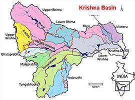
Details of the principal tributaries of Krishna in Karnataka are Ghataprabha, Malaprabha, Bhima and Tungabhadra and details (catchment area, altitude, length) are given below:
Name of the tributary |
Catchment
Sq.kms |
Origin , Altitude & Length |
Sub-tributaries |
Name of the state |
Ghataprabha |
8,829 |
Western Ghats, 884 m, 283 kms |
Hiranyakeshi, Markandeya |
Maharshatra, Karnataka |
Malaprabha |
11,549 |
Western Ghats, 792.48 m, 306 kms |
Bennihalla, Hirehalla, Tas nadi |
Karnataka |
Bhima |
70,614 |
Western Ghats, 945 m, 861 kms |
Combined waters of Mula and Mutha Ghod, Nira,Sina |
Maharastra, Karnataka |
Tungabhadra |
71,417 |
Western Ghats at Gangamula, 1198 m, 531 kms |
Combined waters of Tunga and Bhadra, Varada, Hagari (vedavathy) |
Karnataka & Andhra Pradesh |
|
|
Tungabhadra River |
Tungabhadra River also known as Pampa or Hampi is formed by the Tunga River and Bhadra River that originate in the Western Ghats and flows in Karnataka and Andhra Pradesh. The Tunga and Bhadra Rivers rise at Gangamoola, in Varaha Parvatha in the Western Ghats forming parts of the Kuduremukh, at an elevation of 1198 metres.
Bhadra flows through Bhadravati city and is joined by numerous streams. At Koodli, a small town near Shimoga City, Karnataka, these two rivers meet (Tungabhadra) and then Thungabhadra meanders through the plains to a distance of 531 km and mingles with the Krishna at Gondimalla, near Mahaboobnagar in Andhra Pradesh. Significance of Tungabhadra River are:
- Presence of ancient and holy sites on the banks, for example Harihareshwara temple at Harihara.
- The river surrounds the modern town of Hampi, where are the ruins of Vijayanagara, the site of the powerful Vijayanagara Empire’s capital city and now a World Heritage Site.
- Alampur, on the left – northern bank of the river, known as Dakshina Kashi in Mahabubnagar Dist. The Nava Brahma Temples complex is one of the earliest models of temple architecture in India.
- Bhadravthi, Hospet, Hampi, Mantralayam, Kurnool are located on its bank.
Tributaries of Tungabhadra: Tunga River, Kumudvati River, Varada River, Bhadra River, Vedavathi River, Handri River |
Bhima River |
Bhima River originates in Bhimashankar hills near Karjat in Maharashtra and flows southeast for 861 km through Maharashtra, Karnataka, Andhra Pradesh states. Bhima river catchment is densely populated and form a fertile agricultural area. During its 861 km journey, many smaller rivers flow into it. Kundali River, Kumandala River, Ghod river, Bhama, Indrayani River, Mula River, Mutha River and Pavna River are the major tributories of this river around Pune. Of these Indrayani, Mula, Mutha and Pawana flow through Pune and Pimpri Chinchwad city limits. Chandani, Kamini, Moshi, Bori, Sina, Man, Bhogwati and Nira are the major tributaries of the river in Solapur. Of these Nira river meets with the Bhima in Narsingpur, in Malshiras taluka in Solapur district. Tributaries of Bhima are: Ghod, Sina, Kagini, Bhama, Indrayani, Mula-Mutha, Nira. Significance of this river are:
- Pandharpur city of is on the bank of Bhima River.
- Bhimashankar is one of the twelve esteemed Jyotirlinga shrines. Other temples are Siddhatek, Siddhivinayak Temple of Ashtavinayak Ganesh Pandharpur Vithoba Temple in Solapur district., Sri Dattatreya Temple, Ganagapura, Gulbarga district, Karnataka, Sri Kshetra Rasangi Balabheemasena Temple in Rasanagi, Jevargi Taluq, Gulbarga district, Karnataka
|
Malaprabha River |
Malaprabha River It rises at Kanakumbi in the Belgaum district and joins Krishna River at Kudalasangama in Bagalkot district. It also flows through Dharwar District. Hubli city gets its drinking water from this reservoir. Tributaries of Malprabha: Bennihalla, Hirehalla and Tuparihalla are the major tributaries to Malaprabha. |
Ghataprabha River |
Ghataprabha is a tributary of Krishna that flows in Karnataka with the hydroelectric and irrigational dam at Hidkal. Tributaries of Ghataprabha: Hiranyakeshi and Markandeya rivers are tributaries of Ghataprabha. |
Other tributaries are: Other tributaries are Koyna River (catchment: 4,890 Km2) , Kudali river, Venna River, Yerla River, Warna River, Dindi River (3,490 Km2), Halia (3,780 Km2), Peddavagu (2,343 Km2), Paleru River, Musi River (11,212 Km2), Urmodi River, Tarli River and Dudhganga River. The rivers Venna, Koyna, Vasna, Panchganga (2,575 Km2), Dudhganga (2,350 Km2), Ghataprabha, Malaprabha and Tungabhadra join Krishna from the right bank; while the Yerla River, Musi River, Halia, Maneru and Bhima rivers join the Krishna from the left bank. |
Geology of the Basin |
The geology of the Krishna basin is dominated in the northwest by the Deccan Traps, in the central part by unclassified crystallines, and in the east by the Cuddapah Group. The Dharwars (southwest central) and the Vindhian (east central) form a significant part of the outcrops within the unclassified crystallines. Krishna delta is predominantly formed by Pleistocene to recent material. |
Water Potential |
Surface Water potential |
78.1 km3 |
Ground Water potential |
26.41 km3 |
Hydropower Potential |
Nagarjunsagar |
815 |
Nagarjunsagar RC |
91 |
Nagarjunsagar CH |
61 |
Srisailam |
770 |
Srisailam LB |
900 |
Water Utilization |
Surface Water Utilization |
Drinking |
Irrigation |
Ground Water Utilization |
Drinking |
Irrigation purposes |
Major Projects |
Upper Krishna Project Stage-1,Upper Krishna Project Stage-2, Srisailam dam, Pulichintala project, Nagarjunasagar project, Ghatprabha dam, Tungabhadra project, Vanivilas Sagar project, Bennihora project, Bhadha Reservoir project, Bhima Irrigation project, Hipparagi Barrage, Malprabha project, Upper Tunga project, Koyna dam, Markendaya project, Singatalur lift irrigation, Krishna irrigation project, Osman Sagar reservoir and Prakasam barrage. |
Water Quality of the Basin |
Due to the sustained inflow of untreated sewage and industrial effluents, the water quality is very poor evident from higher values of BOD, lower values of DO and the presence of total coliform. |
Problems in the Basin |
The Krishna basin particularly in east coast faces periodically flood problems in the wake of cyclonic storms. |
Mythology |
Krishna is a mighty east flowing river of peninsular India. It is the same river as Krsnavena in the Puranas or Krsnaveni in the Yoginitantra. It is also known as Kanhapenna in Jatakas and Kanhapena in the Hathigumpha inscription of Kharavela. The word Krishna also indicates dark color |
Important places |
Mahabaleshwar the ‘land of five rivers - Krishna, Koyna, Venna, Gayatri and Savitri’ is located at an altitude of 1,372 meters in the Western Ghats. Some of tourist locations are: Lodwick Point, Arther Point, Elphinstone Point, Tiger’s Spring, Kate’s Point, Bombay Point, Wilson Point, Venna Lake and Kate’s Point, Lingmala, Chinaman and Dhobi waterfalls (http://www.gktoday.in/blog/krishna-river/).
Srisailam (in Andhra Pradesh) is a holy town with a sanctuary (an area of 3568 sq kms) located on the banks of the Krishna. Srisailam is surrounded by lush greenery and has beautiful locations around. Krishna river meanders through Narsobachi, Wadi in Maharashtra and flows through Karnataka to Andhra Pradesh.
Nagarjuna Sagar or Nagarjuna Sagar Dam (one of the world’s largest man-made lake) stretches across the mighty river Krishna. Nagarjunakonda was the largest and most important Buddhist centres in South India.
Amaravati is a small town in Guntur district of Andhra Pradesh and was once the capital of Satavahanas. The Shiva temple is with five lingams -Pranaveswara, Agasteswara, Kosaleswara, Someswara and Parthiveswara. The remains of a 2000-year-old Buddhist settlement along with the great Buddhist stupa are among the main attractions in Amaravati. Mahachaitya or the Great Stupa was constructed approximately 2000 years ago. The stupa is made of brick with a circular vedika and depicts Lord Buddha in a human form, subduing an elephant (http://www.gktoday.in/blog/krishna-river/).
Vijayawada: Vijayawada is the third largest city and a popular trade and commerce centre in Andhra Pradesh on the banks of Krishna River. |
|
T.V. Ramachandra
Centre for Sustainable Technologies, Centre for infrastructure, Sustainable Transportation and Urban Planning (CiSTUP), Energy & Wetlands Research Group, Centre for Ecological Sciences, Indian Institute of Science, Bangalore – 560 012, INDIA.
E-mail : tvr@iisc.ac.in
Tel: 91-080-22933099/23600985,
Fax: 91-080-23601428/23600085
Web: http://ces.iisc.ac.in/energy
Vinay S.
Energy & Wetlands Research Group, Centre for Ecological Sciences, Indian Institute of Science, Bangalore – 560 012, INDIA.
E-mail: svinay@iisc.ac.in
Bharath Settur
Energy & Wetlands Research Group, Centre for Ecological Sciences, Indian Institute of Science, Bangalore – 560 012, INDIA.
E-mail: setturb@iisc.ac.in
Bharath H. Aithal
Energy & Wetlands Research Group, Centre for Ecological Sciences, Indian Institute of Science, Bangalore – 560 012, INDIA.
E-mail: bharathh@iisc.ac.in
Citation: Ramachandra T V, Vinay S, Bharath Settur and Bharath H. Aithal, 2017. Profile of Rivers in Karnataka, ENVIS Technical Report 129, Sahyadri Conservation Series 71, Energy & Wetlands Research Group, CES, Indian Institute of Science, Bangalore 560012
| Contact Address : |
| |
Dr. T.V. Ramachandra
Energy & Wetlands Research Group,
Centre for Ecological Sciences, Indian Institute of Science, Bangalore – 560 012, INDIA.
Tel : 91-80-23600985 / 22932506 / 22933099
Fax : 91-80-23601428 / 23600085 / 23600683 [CES-TVR]
E-mail : tvr@iisc.ac.in, energy@ces.iisc.ac.in,
Web : http://wgbis.ces.iisc.ac.in/energy |
|