|
6.0 |
Venkarapura River |
1 |
Geography |
River Venkatapura is spread across the Western Ghats in Uttara Kannada and Shimoga districts of Karnataka (Figure 1). Originating at Sagara (Figure 2), Originating near Bhimeshwara temple -Sagara (Shimoga), Venkarapura flows for a distance of nearly 50 km (Survey of India Topographic sheets, High resolution satellite data-optical and radar) before it joins Arabian Sea at Alvekodi/ Tenginagundi - Bhatkal (Uttara Kannada) (Figure 2). Tributaries of Venkatapura include, Chitihalla, Katagar Nala, Basti Halla, Kitreholé, Venkatapura river and many more. Venkatapura river has a catchment area of 459.70 sq.km spread across districts of Uttara Kannada (Bhatkal) and Shimoga (Sagar).
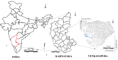
Figure 1: Venkatapura River Location
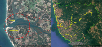
Figure 2: Overlay of Google Earth
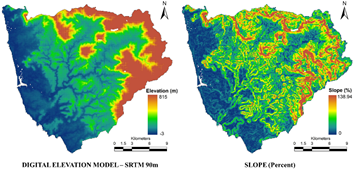
Figure 3: Topography
Topography of Venkatapura river catchment is as depicted in Figure 3, elevation ranges between < 0m and 815m w.r.t Mean Sea Level, slope of the catchment varies up to 119%. Very high slope we observed in the Ghats (Kogar Ghat).
Water falls such as the Bhimeshwara falls etc form in the Ghats of Venkatapura.
Rock types: Granites to schists, shale, quartzite’s, Phyllites.
Ores: Iron, limestone, bauxite, quartz, limestone, sand, clay, shell, Manganese, Asbestos, Mica,Bauxitr
Soil: Red Soil, Lateritic soils, Black soil, etc
|
2 |
Rainfall and Water Yield |
Rainfall assessment in Venkatapura catchment (Figure 4) indicates that rainfall in the catchment is orographic with annual rainfall varying spatially between 3700mm at the plains of coast, to over 5700 mm at the Ghats.
Water yield in the catchment is 8 - 16 TMC
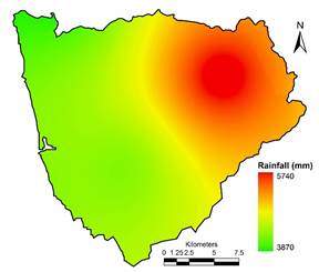
Figure 4: Rainfall
|
3 |
Anthropology |
Population in the catchment (Figure 5) has increased from 153032 in 2001 to 175279 in 2011 (Census of India) and is projected to increase to 188020 in the year 2016 at a growth rate of 14.5% per decade. Population density in the catchment is 404 persons per square kilometer as on 2016. Major Population is contained at towns/villages such as Bhatkal, Shirali, Heble.
Communities: Ambiga, Bedar, Devadiga, Devali, Havyaka Brahmin, Kurubas, Siddis, Konkani Kharvi, Kumri Maratha,Namadhari, Muslims, Jains, etc. (Chandran and Hughes 2000, Gazetter of India-Uttara Kannada district).

Figure 5: Population dynamics in Venkatapura river catchment |
4 |
History, Culture, Heritage |
River Venkatapura has history beyond the Himalayas i.e., 88 Million year compared to Himalayas (50 Million years).
Epic of Mahabharatha explains about Bheemeshwara temple, that was constructed by Bheema, during the agnaythavasa and was established by Dharmaraya on Shivrathri. Arjuna bowed an arrow at the nearby mountain to bring the water for worship which is there even today as Sarala river which has not drained out so far (Tripadvisor web portal).
Culture
- Festivals and Jatras: Hanumantha devara rathotsava, Mahasati Jatra, Mari jatra, Bhavani shankara rathotsava, Mahaganapathi rathotsava,Uura habba (Village Festival), Nadi habba (River festival), Bandi habba, Vadya Panchami, Mahamay jatra, Durga devi jatra, Kannika parameshwari jatra, Shantika parameshwari jatra, Venkataramana jatra, etc
- Dance: Folk dances (suggi kunita), bharatha natya, Kolata, bedara kunita, dhamami kunita, Huli kunita, Yakshagana, Masti Kunita, Preta kuntia, Bedara kunita, Mandala kunita, etc
- Music: Folk Songs, Garatiya Haadu, Halliya Haadu, Nadapadagalu, Bingina pada, Gumatepada, Jogavve haadu, Doni pada, Jogi pada, Badi vadya etc.
- Traditional Games: Kallata, kavade, Channe mane, Karu aata, Katte aata, Hulighatta, Bandi aata, Devarata, Sariya mugila aata, Achchu aata, Chowkabara, Tabalamane, etc.
Religious places in the catchment of Venkatapura includes: Bastis, Khetappayya Narayana,Chindnadapalli mosque etc. |
5 |
Land use dynamics |
Land use analysis of 2013 show that the catchment is dominated by evergreen forest cover (~42.7%), followed by Agriculture (~21.8%), etc. Figure 6 depicts FCC, Figure 7 and Table 1 depicts land use in the catchment as on 2013.
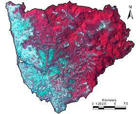
Figure 6: False colour composite

Figure 7: Land use of Venkatapura Catchment
Table1: Land use in Venkatapura Catchment
Land use |
2013 |
Built up |
3.8% |
Water |
0.4% |
Crop land |
21.8% |
Open Space |
2.5% |
Moist Deciduous |
13.5% |
Evergreen - Semi Evergreen Forest |
42.7% |
Scrub/Grass land |
2.2% |
Acacia/Eucalyptus/Casuarina |
7.3% |
Teak/Bamboo/Cashew |
0.8% |
Arecanut/Coconut |
5.1% |
|
6 |
Agriculture, Irrigation |
Variety of Paddy, Sugar cane, Banana, Arecanut, Coconut, Mango, spices, etc. |
7 |
Diversions |
No Major Diversion works in the catchment |
8 |
Bio Diversity |
Bivalves: Ramachandra et al 2012
Villorita cyprinoides
Flora: http://wgbis.ces.iisc.ac.in/biodiversity/database_new (Sagara, Bhatkal Taluks) Forest types found in the district are: Evergreen, Semi Evergreen, Moist Deciduous, Scrub, Thorny, un wooded with following species.
Actinodaphne hookeri, Aglaia ananmallayana, Aglaia roxburghiana, Ailanthus excelsa, Alphonseo sp, Alstonia scholaris, Ancistrocladus hamatus, Aphananthe cuspidata, Aporosa lindleyana, Artabotrys hexapetalus, Artocarpus gomezianus, Artocarpus hirsutus, Beilschmiedia fagifolia, Bischofia javanica, Calophyllum polyanthum, Canarium strictum, Canthium dicoccum, Canthium parviflorum, Caryota urens, Casearia championii, Cassine glauca, Celtis cinnomomea, Chrysophyllum roxburghii, Cinnamomum macrocarpum, Cinnamomum malabathricum, Dillenia pentagyana, Dimocarpus longan, Diospyros buxifolia, Diospyros candolleana, Diospyros montana, Diospyros paniculata, Diospyros sylvatica, Dipterocarpus indicus, Elaeocarpus serratus, Entada pursaetha, Ervatamia heyneana, Ficus nervosa, Flacourtia montana, Garcinia gummi_gutta, Garcinia morella, Glochidion zeylanicum, Gnetum ula, Harpullia imbricata, Holigarna arnotiana, Holigarna ferruginea, Holigarna grahamii, Holigarna nigra, Homalium ceylanicum, Hopea ponga, Hydnocarpus laurifolia, Ixora brachiata, Knema attenuata, Lagerstroemia microcarpa, Linociera malabarica, Litsea floribunda, Lophopetalum wightianum, Macaranga peltata, Mallotus philippensis, Mangifera indica, Mimusops elengi, Myristica dactyloides, Nothopegia racemosa, Olea dioica, Persia macarantha, Pittosporum dasycaulon, Pterospermum diversifolium, Pterospermum reticulatum, Schleichera oleosa, Sterculia guttata, Stereospermum tetragonum, Strombosia ceylanica, Symplocos racemosa, Syzygium cumini, Syzygium laetum, Syzygium travancoricum, Terminalia bellirica, Tetrameles nudiflora, Trichilia connaroides, Vitex altissima, Xantolis tomentosa.
Fauna: : http://wgbis.ces.iisc.ac.in/biodiversity/database_new
Mammals: Tiger, Black Panther, Leopard, Bison, Gaur, Hare, Wild Boar, Sloth Bear, Deer, Thar, Bonnet Macaque, Lion Tailed Macaque, Giant Squirrel, Hanuman Languor.
Reptiles: Snakes (Vipers, Cobra, Rat snake, Krait, King cobra, Python, Wolf snake, etc), Monitor Lizard, etc. |
9 |
References |
- Survey of India Topographic Sheets, 1:50000 scale.
- Water Resource Information System of India, http://www.india-wris.nrsc.gov.in.
- Google Earth, https://www.google.com/earth/.
- Census of India, 2001 and 2011, censusindia.gov.in.
- Wild Wonderful Karnataka, http://www.dreamroutes.org/western/burudefalls.html.
- ENVIS Sahyadri Web Portal, http://wgbis.ces.iisc.ac.in/biodiversity/database_new/
- Chandran, M. D. S., and Hughes, J. D., 2000, Sacred Groves and Conservation: The Comparative History of Traditional Reserves in the Mediterranean Area and in South India, Environment and History, 6, 2, 169–186.
- Gazetter of India, Uttara kannada district, 1985
- Ramachandra, T. V., Chandran, M. D., Joshi, N. V., and Boominathan, M., 2012. Edible Bivalves of Central West Coast, Uttara Kannada District, Karnataka, India., Sahyadri Conservation Series 17, ENVIS Technical Report: 48, Energy & Wetlands Research Group, Centre for Ecological Sciences, Indian Institute of Science, Bangalore 560 012.
- https://www.researchgate.net/profile/T_V_Ramachandra/publications
- http://ces.iisc.ac.in/energy
- http://ces.iisc.ac.in/biodiversity
|
|
T.V. Ramachandra
Centre for Sustainable Technologies, Centre for infrastructure, Sustainable Transportation and Urban Planning (CiSTUP), Energy & Wetlands Research Group, Centre for Ecological Sciences, Indian Institute of Science, Bangalore – 560 012, INDIA.
E-mail : tvr@iisc.ac.in
Tel: 91-080-22933099/23600985,
Fax: 91-080-23601428/23600085
Web: http://ces.iisc.ac.in/energy
Vinay S.
Energy & Wetlands Research Group, Centre for Ecological Sciences, Indian Institute of Science, Bangalore – 560 012, INDIA.
E-mail: svinay@iisc.ac.in
Bharath Settur
Energy & Wetlands Research Group, Centre for Ecological Sciences, Indian Institute of Science, Bangalore – 560 012, INDIA.
E-mail: setturb@iisc.ac.in
Bharath H. Aithal
Energy & Wetlands Research Group, Centre for Ecological Sciences, Indian Institute of Science, Bangalore – 560 012, INDIA.
E-mail: bharathh@iisc.ac.in
Citation: Ramachandra T V, Vinay S, Bharath Settur and Bharath H. Aithal, 2017. Profile of Rivers in Karnataka, ENVIS Technical Report 129, Sahyadri Conservation Series 71, Energy & Wetlands Research Group, CES, Indian Institute of Science, Bangalore 560012
| Contact Address : |
| |
Dr. T.V. Ramachandra
Energy & Wetlands Research Group,
Centre for Ecological Sciences, Indian Institute of Science, Bangalore – 560 012, INDIA.
Tel : 91-80-23600985 / 22932506 / 22933099
Fax : 91-80-23601428 / 23600085 / 23600683 [CES-TVR]
E-mail : tvr@iisc.ac.in, energy@ces.iisc.ac.in,
Web : http://wgbis.ces.iisc.ac.in/energy |
|