|
|
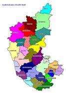
Karnataka is one of the four southern states of Peninsular India (Figure 1a), came into existence with the passage of the States Reorganisation Act (1956, Nov 1) and is located 11°30' North and 18°30' North latitudes and 74° East and 78°30' East longitude (https://en.wikipedia.org/wiki/Geography_of_Karnataka). The state covers an area of 191,976 km² (5.83% of India’s geographical area). Karnataka is the eighth largest Indian state by area, the ninth largest by population and comprises 30 districts (figure 1b) divided in to 4 administrative divisions, 270 towns and 29406 villages (http://ssakarnataka.gov.in/). The state is situated on a table land where the Western and Eastern Ghats ranges converge into the complex, in the western part of the Deccan Peninsular region of India. Karnataka is bordered by the Arabian Sea to the west, Goa to the northwest, Maharashtra to the north, Andhra Pradesh to the east, Tamilnadu to the southeast, and Kerala to the southwest.
Figure 1: Karnataka State, India with districts and River Systems
 |

|
RIVERS OF KARNATAKA:
Rivers are a source of water for drinking, irrigation and electricity generation in Karnataka. Most of the rivers originate in the Western Ghats that generally flow westward meet the Arabian Sea after a short run varying from 50 kilometres to 300 kilometres. Almost all the major east-flowing rivers are inter-state rivers and runs towards the eastern side of the state and drain towards the Bay of Bengal. |
- Karnataka State, India
|
- Districts
|
Figure 1c: River basins -
1: Godavari, 2: Krishns, 3: Cauvery, 4: North Pennar, 5: South Pennar, 6: Palar, 7: West flowing rivers
|
There are seven rivers (Figure 1c) in Karnataka
No. |
River System |
Drainage Area |
|
|
1000 Sq. km |
% |
|
East Flowing Rivers |
|
|
1. |
Godavari |
4.41 |
2.31 |
2. |
Krishna |
113.29 |
59.48 |
3. |
Cauvery |
34.27 |
17.99 |
4. |
North Pennar |
6.94 |
3.64 |
5. |
South Pennar |
4.37 |
2.29 |
6. |
Palar |
2.97 |
1.56 |
7. |
West Flowing Rivers |
24.25 |
12.73 |
|
Total |
190.50 |
100 |
Rivers |
Drainage area |
|
|
1000 sq.km. |
% |
East Flowing rivers (1 to 6) |
166.25 |
12.73 |
West Flowing rivers |
24.25 |
87.27 |
Total |
190.5 |
|
|
1.0 INTRODUCTION
1.1 State profile:
a) Geography and Demography:
Karnataka is one of the four southern states of Peninsular India (Figure 1a), came into existence with the passage of the States Reorganisation Act (1956, Nov 1), with the incorporation of districts under the dominion of Bombay, Hyderabad, Madras State and Coorg within the existing state of Mysore State.Karnataka State is located 11°30' North and 18°30' North latitudes and 74° East and 78°30' East longitude (https://en.wikipedia.org/wiki/Geography_of_Karnataka). The state covers an area of 191,976 km² (5.83% of India’s geographical area). Karnataka is the eighth largest Indian state by area, the ninth largest by population and comprises 30 districts (figure 1b) divided in to 4 administrative divisions, 270 towns and 29406 villages (http://ssakarnataka.gov.in/). The state is situated on a tableland where the Western and Eastern Ghats ranges converge into the complex, in the western part of the Deccan Peninsular region of India.Karnataka is bordered by the Arabian Sea to the west, Goa to the northwest, Maharashtra to the north, Andhra Pradesh to the east, Tamilnadu to the southeast, and Kerala to the southwest. Table 1 provides the details of population, forest types, climate, etc.
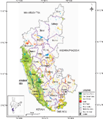
Figure 1: Karnataka State, India with districts and forest types
 |
|
|
- Karnataka State, India
|
- Districts
|
- Forest types
|
|
|
|
|
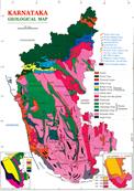
- Geology
|
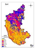
- Soil types
|
- Agro climatic zones
|
- Rainfall
|
TABLE 1: Profile of Karnataka State
State |
Karnataka |
Capital |
Bangalore |
Area |
1,91,791 sq. Km (eighth largest state in India);
Districts: 30; Taluks: 220; Villages: 29406; Towns: 270 |
Length |
760 Km. (north -south) |
Breadth |
420 Km. (east-west) |
Physiography |
Karavali, the Coastal Plain; Sahyadris, the Western Ghats; Malnad, the Transitional Belt; the Southern Plateau; the Northern Plateau; the Eastern Ghats (http://www.karnataka.com/profile/physiography) |
Forest types
(Figure 1c) |
Tropical Evergreen, Tropical Semi-evergreen, Dry Deciduous (Malnad), Dry Deciduous(Plateau), Shrub (http://wgbis.ces.iisc.ac.in/biodiversity) |
Vegetation types |
Wide variety of vegetation formations, ranging from coastal land plants to montane flora of the Western Ghats, four-storied tropical evergreen monsoon forests to arid thorn and scrub. A large chunk of the vegetation of the state is embedded in the sprawling Western Ghats that is also the home to an overwhelming number of plant species with immeasurable biological diversity and a wealth of intricate adaptations. Indeed, a majority of plant species of the Indian subcontinent are represented in the forests of the Western Ghats and account for probably 75% of the state’s plant wealth (http://florakarnataka.ces.iisc.ac.in/hjcb2/karnataka.php). |
Geology (Figure 1d) |
Four main types of geological formations are: (i) The Archean complex made up of Dharwadschists and granitic gneisses: These cover around 60% of the area of the state and consist of gneisses, granites and charnockite rocks. Some of the minerals found in this region are dolomite, limestone, gabbro, quartzite, pyroxenite, manganese and iron ores and metabasalt, (ii) The Proterozoic non-fossiliferous sedimentary formations of the Kaladgi and Bhima series: The Kaladgi series has horizontal rocks that run for 160 km in the districts of Belgaum, Raichur, Dharwad and Bijapur districts. The Bhima series that is present on either side of the Bhima River consists of rocks containing sandstone, limestone and shale and this is present in the Gulbarga and Bijapur districts, (iii) The Deccan trappean and intertrappean deposits: This is a part of the Deccan traps which were formed by the accumulation of basaltic lava. This is made up of greyish to black augite-basalt, and (iv) The tertiary and recent laterites and alluvial deposits: Laterite capping are found over the Deccan Traps and were formed after the cessation of volcanic activity in the early tertiary period. These are found in many districts in the Deccan plateau and also in the coast (http://www.portal.gsi.gov.in). |
Soil types (Figure 1e) |
Soil cane be grouped into 9 categories: red sandy soils, red loamy soils, shallow black soils, medium black soils, deep black soils, mixed red and black soils, laterite soils, laterite gravelly soils and coastal alluvium (http://www.nbsslup.in) |
Soil order |
Alfisols, Andisols, Aridisols, Entisols, Histosols, Inceptisols, Mollisols, Oxisols, Spodosols,Ultisols, Vertisols (http://www.nbsslup.in) |
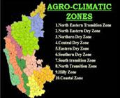
Agro-climatic zones (Fig 1f) |
Ten agro climatic zones in Karnataka (http://raitamitra.kar.nic.in) are: (i). North Eastern Transition Zone [Bidar (5) & Gulbarga (2)], (ii). North Eastern Dry Zone [Gulbarga (5) Yadgir (3) & Raichur (3)], (iii). Northern Dry Zone [Koppal (4), Gadag (4), Dharwad (1), Belgaum (5), Bijapur (5), Bagalkot (6), Bellary (7), Davangere (1), Raichur (2)], (iv). Central Dry Zone [Chitradurga (6), Davangere (3), Tumkur (6), Chickmagalur (1), Hassan (1)], (v). Eastern Dry Zone [Bangalore Rural (4 taluks), Ramanagar (4) Bangalore Urban (3), Kolar (5), Chikkaballpur (6) Tumkur (2)], (vi). Southern Dry Zone [Mysore (4), Chamarajnagar(4), Mandya (7), Tumkur (2), Hassan (2)], (vii).Southern Transition Zone [Hassan (4), Chickmagalur (1), Shimoga (3), Mysore (3), Davanagere (2)], (viii). Northern Transition Zone [Belgaum (4), Dharwad (3), Haveri (6), Gadag (1)], (ix). Hilly Zone [U.Kannada (6), Belgaum (1), Dharwad (1), Haveri (1), Shimoga (4), Chickmangalur (5), Kodagu (3), Hassan (1)], (x). Coastal Zone [Udupi (3), Dakshina Kannada (5), Uttara Kannada (5 taluks) |
Climate |
Semi-tropical (http://www.karnataka.com/profile/karnataka-climate/) |
Seasons |
Summer - March to May (18° C to 40° C); Winter -Oct to Dec (14° C to 32° C); South-West Monsoon: June to August; North-East Monsoon
October to December
(http://www.karnataka.com/profile/karnataka-climate/) |
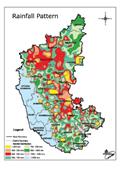
Rainfall (Figure 1g) |
500 mm to over 4000 mm. Agumbe in the Central Western Ghats receives the second heaviest annual rainfall (7600 mm) in India (http://www.karnataka.com/profile/karnataka-climate/) |
Population |
611.31 (approx) (2011), 968 females per 1000 males (http://censuskarnataka.gov.in) |
Population density: |
Top three districts in density of population per sq km are Bangalore Urban (4,378), Dakshina Kannada (457), Bangalore Rural (431) and lowest density districts are Chickmagalur (158), Uttara Kannada (140) and Kodagu (135).
(http://censuskarnataka.gov.in)
Population density in other districts is: Mysore (441), Dharwad (434), Kolar (384), Mandya (365), Belgaum (356), Haveri (331), Davangere (329), Bidar (312), Udupi (304), Ramanagaram (303), Chickballapur (298), Bagalkot (288), Hassan (261), Tumkur (253), Koppal (250), Gulbarga (233), Gadag (229), Raichur (228), Yadgir (224), Bijapur (207), Shimoga (207), Chamarajangar (200) and Chitradurga (197) (http://censuskarnataka.gov.in) |
Literacy |
75.60 % (female literacy: 68.13%; male literacy 82.85%) (http://censuskarnataka.gov.in) |
Traditional Products |
Coffee, silk, sandalwood, agarbathis, ivory carvings, etc. |
Major Crops |
Ragi, jowar, rice; sugarcane, coconut, groundnuts; coffee; cotton
(http:// raitamitra.kar.nic.in/agriprofile/table10.htm) |
Major Minerals |
Gold (90% of India's production), iron ore, manganese, bauxite
(http:// http://www.karnataka.com/profile/mineral-resource/) |
Roads |
Total length of roads: 1,22,489 kms; National Highways: 2,357 kms; State Highways: 28,311 kms; Major District roads: 2,090 kms |
Languages |
Kannada, Telugu, Tamil, Urdu, Marathi, Tulu, Kodagu, Konkani, Hindi |
River systems |
Karnataka has seven river systems and their tributaries flowing through the state. The river systems of Karnataka are: Cauvery, Godavari, Krishna, North Pennar, South Pennar, Palar, The West Flowing Rivers. Karnataka has 26 east flowing rivers and 10 west flowing rivers. The west flowing rivers of Karnataka provide 60% of the state’s inland water resources. (http://www.karnataka.com/rivers/) |
- Physiographic features: The state can be divided into four physiographic landforms – (i) the Northern Karnataka Plateau, (ii) the Central Karnataka Plateau, (iii) the Southern Karnataka Plateau and (iv) the Coastal Karnataka Region.
|
-
Northern Karnataka Plateau: This region is mainly composed of the Deccan trap and covers the districts of Belgaum, Bidar, Bijapur and Gulbarga. It represents an extensive deforested plateau landscape. The Northern Karnataka Plateau has an elevation of 300 m to 600 m asl. The plateau slopes towards the east. The landscape is mainly covered with rich black cotton soils. The vast expanse of treeless plateau is interspersed with river plains, watersheds, residual hills and ridges. The river plains are represented by those of River Bhima, River Ghataprabha, River Krishna and River Malaprabha.
|
Karnataka Coastal Region: The coastal belt starts from the Western Ghats in the west and extends till the edge of the Karnataka Plateau in the east and includes Uttara Kannada, Udupi and Dakshina Kannada districts. The terrain consists of rivers, creeks, waterfalls, ranges of hills and peaks. This region can be divided into two main geographical divisions, known as the Western Ghats and the plains. The coastal belt has an average width of 50 km to 80 km and covers a distance of around 267 km from north to south. |
- Central Karnataka Plateau: This region is located between the Northern Karnataka Plateau and the Southern Karnataka Plateau and consists of districts like Bellary, Chikmagalur, Chitradurga, Dharwad, Raichur and Shimoga. The elevation varies between 450 m to 700 m asl and slope towards the east. This region is the location of the Tungabhadra River basin.
|
- Southern Karnataka Plateau: This region is covered by a high degree of slope and encircled by the Western Ghats on the west and the south. Southern plateau includes the districts of Bangalore Urban, Bangalore Rural, Hassan, Kodagu, Kolar, Mandya, Mysore and Tumkur.. The Southern Karnataka Plateau has a general elevation of 600 m to 900 m asl, except Biligirirangan hills (of Mysore district) and Brahmagiri range (of Kodagu district) have elevation ranging between 1,500 m to 1,750 m. The Cauvery River basin forms a significant part of this plateau.
|
- Hydrogeology: The state is covered by peninsular gneisses, granites, schists, and basalts along with sedimentaries of Kaldagi and Bhima groups. The recent alluvium is restricted to coastal areas and stream courses. The water bearing and yield characteristics in hard rock are primarily controlled by the extent of weathering and fracturing. In limestone areas, solution cavities impart secondary porosity. The yield of tube wells tapping hard rocks is as high as 50 m3/hr. The tube wells in sedimentaries can yield up to 15 m3/hr (http://cgwb.gov.in/gw_profiles/st_karnataka.html).
Dynamic Ground Water Resources |
Annual replenishable Ground water Resource |
15.93 BCM |
Net Annual Ground Water Availability |
15.30 BCM |
Annual Ground Water Draft |
10.71 BCM |
Stage of Ground Water Development |
70 % |
Ground Water Development & Management |
Over Exploited |
65 talukas |
Critical |
3 talukas |
Semi- critical |
14 talukas |
Artificial Recharge to Ground Water (AR) |
- Area identified for AR: 36710 sq km
- Quantity of Surface Water to be Recharged: 2065 MCM
|
Ground Water Quality Problems |
Contaminants |
Districts affected (in part) |
Salinity (EC > 3000 µS/cm at 25 ° C) |
Bagalkot, Belgaun, Bellary, Davangiri,Gadag, Gulburga, Raichur |
Fluoride (>1.5 mg/l) |
Bagalkot, Bangalore, Belgaun, Bellary, Bidar, Bijapur, Chamarajanagara, Chikmagalur, Chitradurga, Davanagere, Dharwad, Gadag, Gulburga, Haveri, Kolar, Koppala, Mandya, Mysore, Raichur, Tumkur |
Chloride (> 1000 mg/l) |
Bagalkot, Belgaum, Gadag, Dharwar |
Iron (>1.0 mg/l) |
Bagalkot, Bangalore, Belgaum, Bellary, Bidar, Bijapur, Chikmagalur, Chitradurga, Dakshina Kannada, Davanagere, Gulburga, Hasan, Haveri, Kodagu, Kolar, Koppala, Mysore, Raichur, Shimoga, Tumkur, Udupi, Uttar Kannada |
Nitrate (>45 mg/l) |
Bagalkot, , Bangalore, Belgaum, Bellary, Bidar, Bijapur, Chamarajanagara, Chikmagalur, Chitradurga, Davanagere, Dharwad, Gadag, Gulburga, Hassan, Haveri, Kodagu, Kolar, Koppala, Mandya, Mysore, Raichur. Shimoga, Udupi, Uttar Kannada |
|
|
|
Groundwater quality |
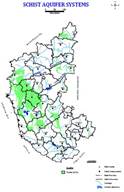
Schist Aquifers |
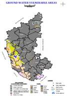
Groundwater Vulnerable area |
Enactment of Ground Water Bill to regulate and control the development of ground water (http://www.groundwaters.in/regulations): Government of Karnataka came up with a new regulation for groundwater in 2009. 2009 bill is a significant shift from 1999 act which was focused solely on drinking water protection. 2009 bill emphasizes on regulation and control of groundwater development and management. This 2009 bill was later passed as an act in 2011 and came to be recognized as Karnataka Groundwater regulations and control of development and management act, 2011. Highlights of this act includes (i) restriction and regulation of extraction of groundwater in the notified area; (ii) Specification of the minimum distance between the bore wells dug for the purpose of irrigation; (iii) Registration of existing and new borewells with the authority within 120 days of formation of authority; (iv) Declaration by notification any areas as drought hit areas; etc.
River Systems of Karnataka: |
|
The rivers are a source of water for drinking, irrigation and electricity generation in Karnataka. Most of the rivers originate in the Western Ghats that generally flow westward meet the Arabian Sea after a short run varying from 50 kilometres to 300 kilometres (http:// http://waterresources.kar.nic.in/river_systems.htm#map). These rivers are very steep in the upper reaches and fairly steep in the middle reaches. Near the sea, they have relatively flat gradients and a mild flood plain. Almost all the major east-flowing rivers are inter-state rivers and runs towards the eastern side of the state and drain towards the Bay of Bengal.
|
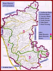
River basins: 1: Godavari, 2: Krishns, 3: Cauvery, 4: North Pennar, 5: South Pennar, 6: Palar, 7: West flowing rivers
|
There are seven river systems in Karnataka.
No. |
River System |
Drainage Area |
|
|
1000 Sq. km |
% |
|
East Flowing Rivers |
|
|
1. |
Godavari |
4.41 |
2.31 |
2. |
Krishna |
113.29 |
59.48 |
3. |
Cauvery |
34.27 |
17.99 |
4. |
North Pennar |
6.94 |
3.64 |
5. |
South Pennar |
4.37 |
2.29 |
6. |
Palar |
2.97 |
1.56 |
7. |
West Flowing Rivers |
24.25 |
12.73 |
|
Total |
190.50 |
100 |
Rivers |
Drainage area |
|
|
1000 sq.km. |
% |
East Flowing rivers (1 to 6) |
166.25 |
12.73 |
West Flowing rivers |
24.25 |
87.27 |
Total |
190.5 |
|
|
i). East-flowing Rivers: Major east flowing rivers in the state are Cauvery (or Kaveri), Krishna, Manjra, North Pennar and Palar
-
Cauvery (or Kaveri) is the largest river in the state and originates at Talakaveri in Coorg. It is often called the Dakshina Ganga (the Ganges of the South) and considered one of the sacred rivers of India. The origin of the River Kaveri, is a famous pilgrimage and tourist spot set amidst Bramahagiri Hills near Madikeri in Coorg. The tributaries of the Kaveri include: Harangi, Hemavathi (origin in western Ghats joins the river Kaveri near Krishnarajasagar), Lakshmanatirtha, Kabini (originates in Kerala and flows eastward and joins the Kaveri at Tirumakudal, Narasipur), Shimsha, Arkavati, Suvarnavathi or Honnuholé, Bhavani, Lokapavani, Noyyal, Amaravati
-
Krishna is second largest river in peninsular India, rises in the Western Ghats at an altitude of 1337 m. near Mahabaleshwar in Maharashtra State. It flows across the whole width of the peninsula, from west to east, for a length of about 1400 km, through Maharashtra (catchment area: 69,425 sq.km), Karnataka (113,271 sq.km) and Andhra Pradesh (76,251 sq.km). The entire catchment area of Krishna basin is 2,58,948 sq km. including the three major basin states (Maharastra (26.81%), Karnataka (43.74%) and Andhra Pradesh(29.45%)). It originates in Maharashtra and passes through Karnataka. The principal tributaries of the Krishna in Karnataka are: Ghataprabha (Origin in the Western Ghats and flows eastwards and joins the river Krishna. The river forms the well-known Gokak Falls in Belgaum District), Malaprabha (origin in Western Ghats and flows first in easterly and north-easterly directions and joins river Krishna at Kudalasangama), Bhima (originates in the forest of Bhimashankar in Pune, and flows through the states of Maharashtra and Karnataka and joins Krishna near Kudlu in Raichur taluk and Tungabhadra (formed in the district of Shimoga, by the union of the Tunga and the Bhadra rivers. The river Tungabhadra flows east across the Deccan Plateau and join river Krishna in Andhra Pradesh). Details of the principal tributaries of Krishna in Karnataka are Ghataprabha, Malaprabha, Bhima and Tungabhadra and details (catchment area, altitude, length) are given below:
Sl. No. |
Name of the tributary |
Catchment
Sq.kms |
Origin , Altitude & Length |
Sub-tributaries |
Name of the state |
1 |
Ghataprabha |
8829 |
Western Ghats, 884 m, 283 kms |
Hiranyakeshi, Markandeya |
Maharshatra, Karnataka |
2 |
Malaprabha |
11549 |
Western Ghats, 792.48 m, 306 kms |
Bennihalla, Hirehalla, Tas nadi |
Karnataka |
3 |
Bhima |
70,614 |
Western Ghats, 945 m, 861 kms |
Combined waters of Mula and Mutha Ghod, Nira,Sina |
Maharastra, Karnataka |
4 |
Tungabhadra |
47,866 |
Western Ghats at Gangamula, 1198 m, 531 kms |
Combined waters of Tunga and Bhadra, Varada, Hagari (vedavathy) |
Karnataka & Andhra Pradesh |
- Manjra, a tributary of the river Godavari, originates in the Bala Ghat range in Karnataka. Details of Manjra River with catchment details is given below.
Sl. No. |
Tributary |
Catchment area in Sq.kms. |
Origin , Altitude |
Sub-tributaries |
state |
1 |
Manjra (tributary of Godavari) |
15,667 Sq.kms Maharastra,
4,406 Sq.kms -Karnataka,
10,772 Sq.kms -Andhra Pradesh |
Bala Ghat range of hills, 823m |
Tirina,Karanja, Haldi,Lendi & Mannar |
Maharastra, Karnataka & Andhra Pradesh |
- North Pennar or the Uttara Pinakini and the South Pennar originate in Nandi hills of Kolar district. Details of catchment extent, origin and length are given below.
Name of the tributary |
Catchment area in Sq.kms. |
Origin , Length |
Sub-tributaries |
State |
Uttara Pinakini (North Pennar River ) |
6937 |
Nandi hills of Kolar, 597km |
Jayamangali, Kumadavathy, Chitravathy and Papagni |
Karnataka, Andhra Pradesh |
- Palar begins in Talagavara in Kolar district and runs through Karnataka, Andhra Pradesh and Tamilnadu.
l. No. |
Name of the tributary |
Catchment area in Sq.kms |
Origin |
Sub-tributaries |
Name of the state |
1 |
South Pennar |
4370 |
Nandi hills of Kolar |
- |
Karnataka, Tamil Nadu |
ii). West-flowing Rivers in Karnataka: The Western Ghats provides a principal geographical barrier in the path of the Arabian Sea branch of the Southwest monsoon, and is principally responsible for the heavy rainfall over the western coastal belt. The Southwest monsoon season (June to September) is the principal rainy season, over 90 % of annual rainfall is realised in this period.
The rivers in the Western Ghats region generally originate at an elevation ranging from 400 meters to 1,600 meters above the mean sea level, close to the Western Ghats ridge. The rivers generally flow westward and meet the Arabian Sea after a short run varying from 50 kms to 300 kms. These rivers are very steep in the upper reaches and fairly steep in the middle reaches and relatively flat gradients near the Sea. Major West flowing rivers are Mandavi, Kali, Bedthi (or Gangavali), Aghnashini, Sharavathi and Vekatapura. The other west-flowing rivers, which run through Karnataka, are the Chakra Nadi, the Varahi, the Netravathy, and the Barapole.
- Mandavi originates in the Western Ghats in Belgaum and flows through Karnataka and Goa.
- Kalinadi originates in Bidi village in the Western Ghats.
- Gangavalli starts in the Western Ghats south of Dharwad.
- Aghanashini begins in the Western Ghats near Sirsi.
- Sharavathi originates at Ambuthirtha in Thirthahalli Taluk, flows north-west through the Western Ghats. It forms the famous Jog Falls before joining the Arabian Sea at Honavara.
Details of the west flowing rivers, their important tributaries are given below:
Sl.No. |
Name of the tributary |
Catchment area in Sq.kms. |
Origin , Altitude & Length |
Sub-tributaries |
Name of the state |
1 |
Mahadayi/ Mandavi |
2,032 |
Western Ghats, Belgaum district, 600 m 87 kms. |
Maderi |
Karnataka,
Goa |
2 |
Kalinadi |
4,188 |
Western Ghats, Bidi village, 600 m, 153 kms. |
Pandhari, Tatti-halla and Nagi |
Karnataka |
3 |
Gangavalli (Bedthi) |
3,574 |
Western Ghats south Of Dharwad 700 m, 152 kms. |
- |
Karnataka |
4 |
Aghanashini (Tadri) |
1,330 |
Western Ghats Near Sirsi, 500 m 84 kms. |
- |
Karnataka |
5 |
Sharavathi |
3,592 |
Westren Ghats Ambutirtha in Shimoga district, 700 m, 128 kms. |
- |
Karnataka |
6 |
Chakra Nadi |
336 |
East of Kodachadri in Shimoga district, 600 m, 52 kms. |
Kollur |
Karnataka |
7 |
Varahi (Haladi) |
759 |
Kavaledur-ga in the Shimoga district, 600 m, 66 kms |
- |
Karnataka |
8 |
Netravathi |
3,222 |
Bellarayan-a Durga in the Dakshina Kannada, 1,000 m, 103 kms |
Gundiahole, Kumaradara and Shisiahole. |
Karnataka |
9 |
Barapole (Valapattanam) |
1,867 |
Brahamagiri Ghat Reserve Forest in Coorg, 900 m, 110 kms |
- |
Karnataka & Kerala |
Independent streams in the west flowing river system of Karnataka are given below:
Kollur River, Ghantihole, Venkatapur, Baindurhole, Shankargundi, Kumbarhole and Yedamavinahole are the important streams in this reach. |
Independent streams between Sharavathi and Chakra rivers joining the Arabian Sea. |
Swarna, Seethanadhi, Mulki river, Pavanje, Nadisalu, Gurpur,Yennehole and Madisalhole. |
Independent streams between Varahi and Netravathi rivers |
Chandragiri (Payaswani) and Shiriya river. The Chandragiri rises west of Mercara in Coorg District of Karnataka State at an elevation of about 600 Mts. Pyayaswani River originates from Patti Ghats reserve forest in Coorg District of Karnataka at an elevation of 1350 Mts. The two river joins together at Machipana about 15 kms upstream of their out fall point into Arabian sea near Kasaragud. It drains catchment area of 1406 Sq kms out of which 836 Sq kms lies in Karnataka state and the balance portion in Kerala state. |
Streams between Netravathy and Chandragiri (Payaswani) |
|
T.V. Ramachandra
Centre for Sustainable Technologies, Centre for infrastructure, Sustainable Transportation and Urban Planning (CiSTUP), Energy & Wetlands Research Group, Centre for Ecological Sciences, Indian Institute of Science, Bangalore – 560 012, INDIA.
E-mail : tvr@iisc.ac.in
Tel: 91-080-22933099/23600985,
Fax: 91-080-23601428/23600085
Web: http://ces.iisc.ac.in/energy
Vinay S.
Energy & Wetlands Research Group, Centre for Ecological Sciences, Indian Institute of Science, Bangalore – 560 012, INDIA.
E-mail: svinay@iisc.ac.in
Bharath Settur
Energy & Wetlands Research Group, Centre for Ecological Sciences, Indian Institute of Science, Bangalore – 560 012, INDIA.
E-mail: setturb@iisc.ac.in
Bharath H. Aithal
Energy & Wetlands Research Group, Centre for Ecological Sciences, Indian Institute of Science, Bangalore – 560 012, INDIA.
E-mail: bharathh@iisc.ac.in
Citation: Ramachandra T V, Vinay S, Bharath Settur and Bharath H. Aithal, 2017. Profile of Rivers in Karnataka, ENVIS Technical Report 129, Sahyadri Conservation Series 71, Energy & Wetlands Research Group, CES, Indian Institute of Science, Bangalore 560012
| Contact Address : |
| |
Dr. T.V. Ramachandra
Energy & Wetlands Research Group,
Centre for Ecological Sciences, Indian Institute of Science, Bangalore – 560 012, INDIA.
Tel : 91-80-23600985 / 22932506 / 22933099
Fax : 91-80-23601428 / 23600085 / 23600683 [CES-TVR]
E-mail : tvr@iisc.ac.in, energy@ces.iisc.ac.in,
Web : http://wgbis.ces.iisc.ac.in/energy |
|