|
7.0 |
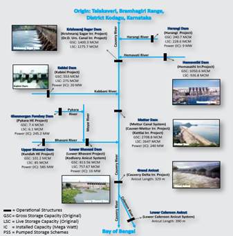
Cauvery River |
Cauvery (or Kaveri) is the largest river in the state and originates at Talakaveri in Coorg. It is often called the Dakshina Ganga (the Ganges of the South) and considered one of the sacred rivers of India. the origin of the River Kaveri, is a famous pilgrimage and tourist spot set amidst Bramahagiri Hills near Madikeri in Coorg. The tributaries of the Kaveri include: Harangi, Hemavathi (origin in western Ghats joins the river Kaveri near Krishnarajasagar), Lakshmanatirtha, Kabini (originates in Kerala and flows eastward and joins the Kaveri at Tirumakudal, Narasipur), Shimsha, Arkavati, Suvarnavathi or Honnuholé, Bhavani, Lokapavani, Noyyal, Amaravati |
Salient Features of Cauvery Basin
1 |
Catchment Area (Sq. Kms) |
85,000 |
2 |
Basin Extent - Longitude
Latitude |
75° 30’ to 79° 45’ E
10° 05’ to 13° 30’ N |
3 |
Length of Cauvery River (Km) |
800 |
4 |
Average Water Resource Potential (MCM) |
21358 |
5 |
Utilizable Surface Water Resource (MCM) |
19000 |
6 |
Live Storage Capacity of Completed Projects (MCM) |
8978.00 |
7 |
Live Storage Capacity of Projects under cnstruction (MCM) |
15.0 |
8 |
Total Live Storage Capacity of Projects (MCM) |
8993.00 |
9 |
No. of Hydrological Observation Stations (CWC) |
34 |
10 |
No. of Flood Forecasting Stations (CWC) |
- |
|
Brief Description |
- The Cauvery River rises in the Western Ghats and flows in eastwardly direction passing through the states of Karnataka, Tamil Nadu, Kerala and Pondicherry before it drains into Bay of Bengal. The basin lies between latitudes 100 05’ N and 130 30’ N and longitudes 750 30’ E and 790 45’ E.
- It is bounded on the west by the Western Ghats, on the east and south by the Eastern Ghats and on the north by the ridges separating it from the Tungabhadra (Krishna) and Pennar basins.
- The total length of the river from source to its outfall into Bay of Bengal is about 800 km. Of this, 320 km is in Karnataka, 416 km is in Tamil Nadu and 64 km forms the common boundary between Karnataka and Tamil Nadu States.
- The Cauvery basin extends over an area of 85,000 km2, which is nearly 24.7% of the total geographical area of the country
- The basin lies in the States of Tamil Nadu (55.44%), Karnataka (41.23%), Kerala (3.33%).and Pondicherry
- The shape of the basin is somewhat rectangular with a maximum length and breadth of 360 km and 200 km, respectively.
|
|
|
|
|
|
Upper Sub-Basin (WRIS) |
Middle (WRIS Portal) |
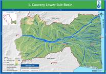
Lower basin (WRIS Portal) |
Flow of river Cauvery (Source: WRIS Portal http://wrmin.nic.in)
 |
Physiography |
Physiographically, the basin can be divided into three parts: the Western Ghats area, the Plateau of Mysore and the Delta. The delta area is the most fertile tract in the basin. |
Drainage Area (Km2) |
Statewise Drainage Area (Km2) |
Name of State |
Drainage area |
Tamil Nadu |
43,867 |
Karnataka |
34,273 |
Kerala |
2,866 |
Pondicherry |
149 |
Geology of the Basin |
The geology of the drainage basin is predominantly formed from Precambrian rocks, principally the Dharwars, Peninsular granitic Gneiss, Charnockites and the Closepet Granite. The Dharwar metamorphics mainly comprise of phyllites, slates, schists with chlorite, biotite, garnet, and hornblende. Accompanying these are greenstones and quartzite. The Closepet Granite of the upper reaches of the Cauvery basin is a pink granite consisting mainly of quartz, plagioclase, microcline, perthite, and subordinate hornblende. Over the main basin, the peninsular granites and gneisses comprising of biotite granitic gneiss, hornblende granitic gneiss are widely found. The Charnockites are confined to the Nilgiri Range in the central part of the drainage basin. These are represented by gabbros, olivine norites, and pyroxene. Cretaceous sediments crop out in the coastal region and consist of conglomeratic sandstone, coralline limestone, and shale. |
Soil of the Basin |
The principal soil types found in the basin are black soils, red soils, laterites, alluvial soils, forest soils, and mixed soils. Red soils occupy large areas in the basin. Alluvial soils are found in the delta areas. The culturable area of the basin is about 58,000 km2 which is about three percent of the culturable area of the country. |
Forest
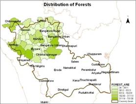 |
Out of the total area of the basin, the area under forest is just 19.53%. In Kerala part of the basin, the forest cover is much higher but considering that area forms a small part of the basin, this comes out to be negligible. The forest cover is much below the desirable forest cover of 33%. The minimal forest cover is in the districts of Thanjavur (1.5%), Tumkur (2%) and Mandya (4.8%). These forests are ecologically unique and very rich. Home to some of the unique flora and fauna, the area is famous for its many sanctuaries. |
Climate of Cauvery
Basin |
Cauvery basin experiences tropical climate. Here, the main climatic feature is the monsoon rain. The north-east monsoon provides the greater portion of the annual precipitation. The far north-western part of the drainage basin has a per-humid climate which passes eastwards into humid, moist sub-humid, dry sub-humid and semi-arid zones. The recorded maximum and minimum temperatures are 44°C and 18°C respectively.
The highest rainfall in the basin is received along the western border of the basin during the southwest monsoon. The eastern side of the basin gets most of the rain during the northeast monsoon. Depressions in the Bay of Bengal affect the basin in the monsoon, causing cyclones and widespread heavy rains |
Water Potential of the Basin |
Surface Water potential |
66.88 km3 |
Ground Water potential |
16.46 km3 |
Major Tributaries with drainage area in sq. km. |
The important tributaries joining Cauvery in the Coorg district are the Kakkabe, the Kadanur and the Kummahole. Cauvery then enters the Mysore district where important tributaries joining the river from the left are the Harangi, the Hemavathi, the Shimsha and the Arkavathi. The tributaries joining it from the right are the Lakshmanathirtha, the Kabbani, and the Survanavathi. Further down, the river enters Tamil Nadu state where the many tributaries, namely, the Bhavani, the Noyil, and the Amravathi join it. |
Major Projects |
Krishnaraja sagar dam, Nugu, Mettur and Grand Anicut projects |
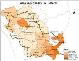
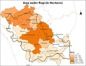
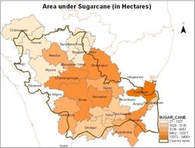
Agriculture |
The major part of basin is covered with agricultural land accounting to 66.21% of the total area and 4.09% of the basin is covered by water bodies. The basin spreads over 33 parliamentary constituencies (2009) comprising 18 of Tamil Nadu, 11 of Karnataka, 3 of Kerala and 1 of Puducherry. |
|
|
|
|
Water Quality |
Several studies were made by the Central Pollution Control Board to ascertain the status of water quality in the Cauvery River. The results show that at many places, the quality of water was quite poor compared to what was the desired class. |
Problems in the Basin |
Occasional flood problem in lower reaches and delta areas of Cauvery river. |
Mythology |
The Cauvery River, also known as Dakshin Ganga or 'Ganga of South', is one of the holy rivers of South India. |
|
T.V. Ramachandra
Centre for Sustainable Technologies, Centre for infrastructure, Sustainable Transportation and Urban Planning (CiSTUP), Energy & Wetlands Research Group, Centre for Ecological Sciences, Indian Institute of Science, Bangalore – 560 012, INDIA.
E-mail : tvr@iisc.ac.in
Tel: 91-080-22933099/23600985,
Fax: 91-080-23601428/23600085
Web: http://ces.iisc.ac.in/energy
Vinay S.
Energy & Wetlands Research Group, Centre for Ecological Sciences, Indian Institute of Science, Bangalore – 560 012, INDIA.
E-mail: svinay@iisc.ac.in
Bharath Settur
Energy & Wetlands Research Group, Centre for Ecological Sciences, Indian Institute of Science, Bangalore – 560 012, INDIA.
E-mail: setturb@iisc.ac.in
Bharath H. Aithal
Energy & Wetlands Research Group, Centre for Ecological Sciences, Indian Institute of Science, Bangalore – 560 012, INDIA.
E-mail: bharathh@iisc.ac.in
Citation: Ramachandra T V, Vinay S, Bharath Settur and Bharath H. Aithal, 2017. Profile of Rivers in Karnataka, ENVIS Technical Report 129, Sahyadri Conservation Series 71, Energy & Wetlands Research Group, CES, Indian Institute of Science, Bangalore 560012
| Contact Address : |
| |
Dr. T.V. Ramachandra
Energy & Wetlands Research Group,
Centre for Ecological Sciences, Indian Institute of Science, Bangalore – 560 012, INDIA.
Tel : 91-80-23600985 / 22932506 / 22933099
Fax : 91-80-23601428 / 23600085 / 23600683 [CES-TVR]
E-mail : tvr@iisc.ac.in, energy@ces.iisc.ac.in,
Web : http://wgbis.ces.iisc.ac.in/energy |
|