Forests are a precious gift of nature, meant to be intensively exploited and simultaneously tended and cultured so that they go on giving a sustained or even an increasing yield every year. This is because forests provide array of goods such as timber, firewood, industrial raw materials for making paper, rayon and minor forest produce like honey, wax, soap nut, medicinal plants etc. The Forest resources have an important bearing on the environmental or ecological security and well being of the country and its people. Forest ecosystems preserve the physical features, minimize soil erosion, prevents floods, check the flow of subsoil water and help to maintain the productivity of cultivated lands.
1. FOREST MANAGEMENT:PRESENT STATUS
Karnataka with the geographical area of 191,791 km2, in southern peninsular India has forest area of 38,284 km2 (19.96% of geographical area). Reserved forests (India State of Forest report 2011)constitute a major share (74.94%) followed by protected forests (10.72%) and un-classed forests (14.79%). Administratively, the State is divided into 13 Forest Territorial Circles, 40 Territorial Divisions (Karnataka forest department Annual Report, 2010).
Shimoga circle: As per Mysore government order G.5034.5.FT. 101-27.3 dated 11 November 1927,Shimoga circle was constituted in 1927 consisting of Shimoga, Bhadravathi, Sagar, Koppa and Chikmaglur divisions of Shimoga and Chikmaglur revenue district (Upto 30-11-2001). Subsequently, the Koppa and Chikmaglur divisions are removed from Shimoga circle and included in Chikmaglur circle (with effect from 1-12-2001) andShimoga wildlife division was added to the Shimoga circle (Annual report, Shimoga Circle 2012).
The administration of the Forest Department in the district is under the charge of the Conservator of Forests (CF), Shimoga Circle, Shimoga. The district has been divided into three Forest Divisions, namely, Shimoga, Bhadravati and Sagar Divisions (Figure 1), each headed by a Divisional Forest Officer (DFO). There are thirty three forest ranges corresponding to the seven revenue taluks of the district. Each forest range is placed under the charge of a Range Forest Officer (RFO). The ranges are further divided into sections, and each section is under the charge of a Forester. Further, each section is sub-divided into beats, and each beat is under the charge of a Forest Guard who is assisted by a Watcher. Thus, there are thirty three Range Forest Officers (in the district under the administrative control of the three Divisional Forest Officers. And they are assisted by 12 Assistant Conservator of Forests ACF), 33 Range Forest Officers; in all three Forest Divisions (Annual report, Shimoga circle 2012).
Area under forest constitutes 51.99% of the geographical area (8477 sq.km). Table 1 lists forest cover under different categories as per FSI (Forest Survey of India) during 1991 to 2011. Table 2 lists categorywise area under forests during 1990-91 to 2009-10. Current area under forests is about 78% (with the inclusion of 2305 sq.km unclass forests). Table 3 lists the area under forests for each division. Sagar division with 30.79% (1217 sq.km) leads the area under forests in Shimoga circle, followed by Bhadravathi (22.26%; 870 sq.km), Shimoga (22.02%; 1038 sq.km), Wildlife division (20.99%; 827 sq.km). Categorywise forests are listed in Table 4; Area under reserve forests constitute 43.3%, followed by unclassified forests (35.35%) and protected forests (18.2%). Table 5 list type wise forests which include evergreen (45.8%), moist deciduous (25.7%), semi-evergreen (13.7%), Shola (9%), etc.
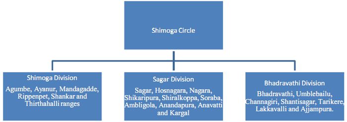
Figure 1: Forest administrative framework in the district
Table 1: Forest coverin Shimoga district (FSI 1991-2011)
| Year |
Geographical area(sq.km) |
Forest cover (sq.km) |
% of forest cover to geographical area |
Scrub |
| Dense |
Open |
Mangrove |
Total |
| 1991 |
10553 |
4036 |
885 |
0 |
4921 |
46.63 |
|
| 1993 |
10553 |
4009 |
909 |
0 |
4918 |
46.6 |
|
| 1995 |
10553 |
4012 |
911 |
0 |
4923 |
46.65 |
|
| 1997 |
10553 |
4026 |
888 |
0 |
4914 |
|
168 |
| 1999 |
10553 |
4009 |
891 |
0 |
4900 |
|
179 |
| 2001 |
8477 |
3117 |
1356 |
0 |
4473 |
52.77 |
36 |
| 2003 |
8477 |
3075 |
1401 |
0 |
4476 |
52.8 |
|
| 2005 |
8477 |
3075 |
1402 |
0 |
4477 |
52.81 |
23 |
| 2007 |
8477 |
3014 |
1394 |
0 |
4408 |
52 |
23 |
| 2011 |
8477 |
3013 |
1394 |
0 |
4407 |
51.99 |
23 |
Table 2: Forest Area of Shimoga district (Karnataka State Forest Department)
| Year |
Geographical Area(sq.km) |
Forest Area (sq.km) |
Percentage of Forest Area to Geographical Area |
| Reserved |
Protected |
unclassed |
Village |
Private |
Total |
| 1990-91 |
10576 |
1945.72 |
1298.28 |
21.57 |
13.59 |
- |
3270.16 |
30.92 |
| 2000-01 |
8465 |
1945.72 |
1298.28 |
21.57 |
13.59 |
- |
3270.16 |
38.63 |
| 2001-02 |
8465 |
1945.72 |
1298.28 |
21.57 |
13.59 |
- |
3270.16 |
38.63 |
| 2002-03 |
8465 |
1945.72 |
1298.28 |
21.57 |
13.59 |
- |
3270.16 |
38.63 |
| 2003-04 |
8465 |
1945.72 |
1298.28 |
21.57 |
13.59 |
- |
3270.16 |
38.63 |
| 2005-06 |
8465 |
1945.72 |
1298.28 |
21.57 |
13.59 |
- |
3270.16 |
38.63 |
| 2006-07 |
8465 |
3127.66 |
1190.99 |
2305.35 |
7.44 |
- |
6631.44 |
78.34 |
| 2008-09 |
8477 |
3127.66 |
1190.99 |
2305.35 |
7.44 |
- |
6631.44 |
78.34 |
| 2009-10 |
8477 |
3127.66 |
1190.99 |
2305.35 |
7.44 |
- |
6631.44 |
78.34 |
Table 3: Area of Forests of different divisions in Shimoga circle (New proforma 1, KFD)
| Divisions |
Forest Area in Hectares |
| 2006 |
2007 |
2008 |
2009 |
2010 |
2011 |
| Sagar |
121460 |
121759.5 |
121759.5 |
121759.5 |
121759.5 |
121759.5 |
| Shimoga |
75101.58 |
75101.58 |
75101.58 |
81782 |
81782 |
87073.01 |
| Bhadravathi |
103297.1 |
103297.1 |
103430.3 |
103216 |
103875.3 |
103875.3 |
| WLDnShimoga |
82756.7 |
82707.44 |
82707.44 |
82707.43 |
82707.43 |
82707.43 |
| Total |
382615.38 |
382865.6 |
382998.8 |
389465 |
390124.3 |
395415.3 |
Table 4: Area of different class of forests in Shimoga circle as per Form 23 KFD
| Class of forests |
Area as on April 2005 (Ha) |
Area as on April 2006 (Ha) |
Area as on April 2007 (Ha) |
Area as on April 2008 (Ha) |
Area as on April 2009 (Ha) |
Area as on April 2010 (Ha) |
| Reserved forest |
292685.5 |
293027.79 |
293460.55 |
302353.16 |
302357.61 |
302347.37 |
| Protected forest |
85091.95 |
85091.95 |
85091.95 |
119098.63 |
119098.63 |
119098.66 |
| Village forest |
743.95 |
743.95 |
743.95 |
743.95 |
743.86 |
743.86 |
| Unclassified forest |
3256.29 |
3256.29 |
3256.29 |
230534.92 |
230534.92 |
230534.92 |
| Deemed forest |
23578.79 |
23578.79 |
23578.79 |
0 |
0 |
0 |
| Others |
18138.85 |
18138.85 |
18138.85 |
0 |
0 |
0 |
| District forest |
10432.8 |
10432.8 |
10432.8 |
0 |
0 |
0 |
| Total |
433928.13 |
434270.42 |
434703.18 |
652730.66 |
652735.02 |
652724.81 |
Table 5: Forest Area by types (Proforma 2) for Shimoga circle
| Type of Forests |
Area in Hectares |
|
| 2006 |
2007 |
2008 |
2009 |
2010 |
2011 |
% |
| Evergreen |
59119.62 |
69459 |
69458.56 |
161477.12 |
161477.12 |
176056.5 |
45.8 |
| Semi evergreen |
57643.11 |
88135 |
88135.41 |
52792.15 |
52792.15 |
52792.17 |
13.7 |
| Moist deciduous |
68363.66 |
130612 |
130611.7 |
101790 |
98740.7 |
98740.7 |
25.7 |
| Dry deciduous |
50130.52 |
109539 |
109677.6 |
2625 |
2625 |
2625 |
0.7 |
| Shola |
89493.79 |
24111 |
24111.26 |
31070.4 |
34559.4 |
34559.4 |
9.0 |
| Grassy blank |
5209.87 |
5103 |
10898.97 |
5840.35 |
5840.35 |
4226.31 |
1.1 |
| Others |
980.91 |
7557 |
1760.614 |
5107.14 |
5107.14 |
5107.14 |
1.3 |
|
0 |
|
6282.72 |
6282.72 |
6282.72 |
1.6 |
|
|
|
2591.36 |
2591.36 |
4205.96 |
1.1 |
| TOTAL |
330941.48 |
434516 |
434654.1 |
369576.24 |
370015.94 |
384595.9 |
100 |
Shimoga Division
Shimoga division located between 13°21' to 14° 8'N and 75 °5' to 75° 45' E (Figure 2),is the old division established during the year 1920. It borders Davangere district in the north, Chikmagalore district in the south and south west, Dashina Kannada and Udupi districts in the west. The forests of the division almost entirely lie within Shimoga district extending over major parts of Shimoga and Thirthahallitaluks and a small part of Hosanagarataluk. A very small part of Honallitaluk of Davangere district is also included in the division.The rivers Kumudvathi and Kushavathiborder the state forest boundaries of Masrur, Arasalu and Kumsi in the East. Tunga and Tungabhadra rivers bound the division in the northwest.
The total forest area coming under the Shimoga as per working plan 2001 is 67551.44 hectares of which 26388.52 hectares are State forests and 35843.36 hectares are minor forests.The forest consists of about 13,000 hectares of evergreen and semi-evergreen forests about 23,000 hectares of closed deciduous forests about 12,500 hectares of plantations and about 19,000 hectares of degraded and open forest lands in the division.The forests of Shimoga division can be classified as following types:
- Southern tropical wet evergreen forests: These types of forests occur in Agumbe state forest and Balehalli state forest of Agumbe range.
- Southern tropical semi evergreen forests: These forests mostly occur in Thirthahalli, Mandagadde and Sacrebyle ranges besides the borders of moist deciduous forests of Shanker and Rippanpet ranges in places of high elevations having moderate to heavy rainfall.
- South tropical moist deciduous forests: The forests of Purdal, Anesara, Shankar, Sacrebyle, Hangere, Bommenahalli, Mugudthi, Kumsi, Sudur, Part of Kudi, Masrur, Arasalu part of Kumudvathi and Burve are typical representatives of this type.
- Southern tropical dry deciduous forests: The mixed dry deciduous forests are found mostly in areas with rainfall of 30" to 50" in Shimogataluk in Ayanur range. These are also spread over in other ranges in the minor and district forests of the division. These forests contain shrubby growth and also scattered miscellaneous species such as Mathi, Nandi, Hunal, Honne, Yethiga, Beete, Dindiga, Neralu, Jambe, Buruga, Thare and Teak but is of poor quality.
- South tropical Scrub forests: These types of forests are found in northern portion of Ayanur, Shankar and Honnali ranges.
The entire forests of Shimoga division form the catchment and are distributed towards the left of Tunga and Tungabhadra rivers. At present Shimoga forest division has three sub divisions, six territorial ranges attached with small depots to range headquarters and one major timber depot and one sandal koti. There are six ranges in the division, namely Agumbe, Ayanur, Mandagadde, Rippenpet, Shankar and Thirthahalli ranges. (Working plan Shimoga division, 2001).
Sagar Division
Sagar division is located at 13º 36’ to 14º 38' N and 74º 38' to 75º 32' E (Figure 3),in Shimoga revenue district and comprises of Sagar, Hosnagar, Shikaripura and Sorabataluks. Sagar division became a separate administrative unit in 1916 and has 3 sub-divisions with headquarters at Sagar, Hosnagar and Shikaripura. There are 10 ranges namely Sagar, Hosnagara, Nagara, Shikaripura, Shiralkoppa, Soraba, Ambligola, Anandapura, Anavatti and Kargal. Sagar Forest Division has the total Forest area of 1,47,829.40 ha of forests.The total extent of forest area transferred from Sagar territorial division to Shimoga Wildlife division is 21400.86 ha.Besides 6,396.77 hectares and3,494.50 hectares of forestland have been transferred to the Karnataka Forest DevelopmentCorporation (KFDC) limited and the Mysore Paper Mills (MPM) limited respectively for raisingplantations.Totalextent of forest area in the division is about 1, 16,754.27 ha.(Working Plan, Sagar division, 2003).The forests of Sagar division occurring inHosnagara, Nagara, Kargal and Sagar ranges are:
- Evergreen Forests:
Southern tropical wet evergreen forests
Southern tropical semi evergreen forests
The deciduous types are spread over in all the other ranges of the division.
- Deciduous forests:
South tropical moist deciduous forests
Southern tropical dry deciduous forests
Bhadravathi Division
Bhadravathi division is located at 13º 30' to 14º 21'N and 75º 30' to 76º 7' E (Figure 4) andcomprises of Bhadravathi, Channagiri, Tarikere, Shimoga and Honnalitaluks. This division came into effect from 1-7-1962. It has 4 sub divisions with 7 ranges namely Bhadravathi, Umblebailu, Channagiri, Shantisagar, Tarikere, Lakkavalli and Ajjampura. The forests stretch from Kakanahosudi State forest on the west to Tuppadalli State forest on the east and from Yelavadalli State forest on the north to Bababudangiri State forest on south.
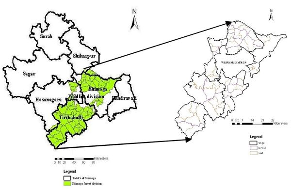
Figure 2: Shimoga division with range, section and beats
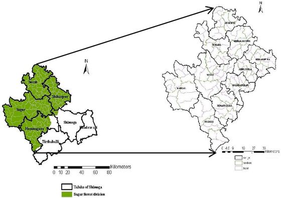
Figure 3: Sagar division with range, section and beats
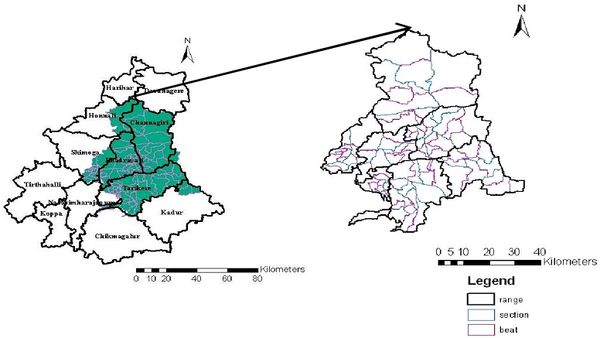
Figure 4: Bhadravathi division with Range, section and beats
Bhadravathi forest division with a total geographical area of 5106.13 Sq.km is spread over about 80 km in north south direction about 65 km in the east-west direction. The forest types of division are as follows:
Southern moist mixed deciduous forest: This type of forest is seen in parts of KukwadaUbrani, Antharagange, Chornedehalli and Kakanahosudi state forests.
Southern tropical dry teak bearing forest: Forests of this type are seen in Eastern part of KukwadaUbrani State forest, Northwestern part of Kakanahosudi state forest, Western part of Rangainagiri state forest, central and south part of Bhadrapura state forest, northern part of Antharagange state forest, Tyagadabagi state forests, Tammadihalli, Umblebyle state forests and southwestern part of Gangur state forest (Working Plan Bhadravathi division, 2003).
Dry deciduous scrub: These types can be seen in Udev state forest, Jedikatte and Gangur state forests and all minor forests of the division.
Before 1920, the forests included in the present Bhadravathi division constituted parts of Shimoga and Kadur forest divisions. In 1920-21 these forests were included in Tarikere and Benkipura(Bhadravathi) firewood supply divisions that were created to meet the huge fuelwood requirements of Iron and Steel industry setup at Bhadravathi during 1916. The Bhadravathi firewood supply division was abolished in 1962 and Bhadravathi division came into effect from 1-7-1962. During 1992, parts of Lakkavalli, Tarikere, Bhadravathi and Umblebyle range coming under Bhadravathi wildlife Sanctuary are separated and included under Bhadra Wildlife division. The trend in areas of Bhadravathi forest division from 1920-1956 is given in table 6.1.
The total area of state forests, Reserved forests, Minor forests and other types of forests such as wooded blocks, kaval lands and Sandal reserves of Bhadravathi division as per 2003 Working plan is 1, 14,102.92 ha comprising 89,568.14 ha of state forests, 20,184.28 ha of minor forests, 169.69 ha of reserved forests 2,368.97 ha of reserved lands 572.14 of sandal reserves 1,211.38 ha of wooded block and 28.32 ha of plantation.The total extent of forest area transferred from Bhadravathi territorial division to Bhadra wildlife division is 18494.34 hectares. Besides this 2679.61 ha and 5796.16 ha of forest lands have been transferred to the Karnataka Forest Development Corporation (KFDC) and Mysore Paper Mills (MPM) respectively for raising plantations (Working Plan Bhadravathi division, 2003). The area of Bhadravathi forest division from 2006 to 2011 is given in Table 3.
2. HISTORY OF FOREST MANAGEMENT
Mysore forest department: The Mysore forest department was formed in 1864. In the past, the importance was given mainly to selection felling and improvement felling with the primary objective of revenue collection. Timber was mainly brought to the depots for sale.
Trends of forest areas in Mysore presidency: Land utilization trends have changed dramatically in Mysore presidency during the post-Forest Act period. Available data indicates an increase in forest cover from 36.35 lakh hectares(in 1893–1894) to 52.55 lakh hectares(in 1915–1916). It has further gone up to 53.45 lakh hectares in the subsequent decade. It remained more or less the same for the rest of colonial period. In other words, the proportion of forest area has witnessed a marginal increase from 15.57 per cent of the total geographical area in 1884–1885 to 16.40 per cent in 1946–1947. Land not available for cultivation which has risen from 44.92 lakh hectares in 1884–1885 to 96.07 lakh hectares in 1910–1911, however, this has declined in the subsequent decades. In 1946–1947, it has come down to 56.88 lakh hectares (Mysore Forest Administrative Report, 1893-1956). ). Table 6 lists area under state and reserve forests during 1893 to 1915 in Shimoga district.
Table 6: Area under state and reserve forests during 1893 to 1915 in Shimoga district (Mysore forest administrative report)
| Year |
Area of State forest (Hectares) |
Reserved Forests (Hectares) |
Plantations (Hectares) |
| 1893 |
91944.65 |
|
|
| 1894 |
91944.65 |
|
|
| 1895 |
90131.65 |
230.51 |
|
| 1896 |
90131.65 |
230.51 |
|
| 1897 |
90131.65 |
230.51 |
|
| 1901 |
89769.05 |
|
|
| 1902 |
89769.05 |
|
|
| 1904 |
88836.66 |
|
|
| 1906 |
89095.66 |
39626.85 |
|
| 1907 |
95829.63 |
41180.84 |
|
| 1908 |
110851.6 |
|
|
| 1909 |
120952.5 |
46101.82 |
1036 |
| 1910 |
124578.5 |
|
|
| 1911 |
124578.5 |
82361.68 |
1036 |
| 1912 |
124578.5 |
82620.68 |
1036 |
| 1913 |
135456.5 |
70447.73 |
1036 |
| 1914 |
138435 |
67080.74 |
1036 |
| 1915 |
139631.5 |
65526.75 |
1036 |
Expansion of agriculture
Expansion of agriculture was notable in the Mysore Presidency during the post-Forest Act period. Despite an increase in current fallows, the net sown area has gone up progressively during this period. For instance, in 1884–1885, 86.33 lakh hectares of land was the net sown area and it has shot up to 125.59 lakh hectares in 1946–1947. In other words, the proportion of net sown area, which was 37 per cent of the total geographical area in 1884–1885, had risen to 39.05 per cent in 1946–1947. This highlights that more and more land was brought under the cultivation during the late nineteenth century and early twentieth centuries in the Mysore Presidency (Mysore Forest Administrative Report, 1893-1956.
3. PAST MANAGEMENT IN SHIMOGA FOREST DIVISIONS
Bhadravathi:
The pre-working plan period: This period refers to management of forests prior to 1898 when there were no systematic working plans. After formation of the forest department in 1864 various forest areas were placed under the protection of forest department. The valuable forests of Lakkavalli and Chornedehalli were the first to be placed under protection of forest department in Bhadravathi division (Working Plan Bhadravathi division, 2003). During that timelittle attention was paid to protection and regeneration of forests. Col.Campbell Walker ordered for preparation of working plans for some of the important forests of Bhadravathi division. Seetharamaiah drew up first working plan in 1900 for KukwadaUbrani State Forest(Working Plan Bhadravathi division, 2003).
In 1902 a provisional working scheme based on silvicultural principles was drawn up and applied to all the forests of Bhadravathi division. The provisional plan provided for fire protection, climber cutting, planting, sowing, coppicing, etc. in order to improve the growing stock.
In 1907 regular working plan for the first time for KukwadaUbrani forest was worked out. During 1910 working plan was prepared for Lakkavalli and Thyagadabagi. Working plan for Kakanhosudi, Aldhara, Umblebyle and Chornedehalli forests were prepared during 1916 and Kukwada, Ubrani, Rangainagiri, Hadikere and Gurupura forests during 1919.
Period of firewood supply from 1919 to 1935: This period has brought a lot of changes in the working of forests. After the introduction of tramways for transport of firewood to Bhadravathi Iron factory, rearrangement of working plan areas was made and heavy exploitation was carried out in forest areas adjacent to the tramways. The extraction of fuel wood till 1923 was mainly controlled by old working plans with modification and addition of district forest areas to the extent of 7360 areas.
During 1924, in addition to state forests 10240 acres of district forests were also covered since the district forest were often nearer to the tramways than the state forests (Working Plan, Bhadravathi division, 2003). In 1943 Mysore Iron and Steel Works factory started transporting charcoal from distant forests. In 1962 another working plan was written for supply of firewood and charcoal to MSIL and bamboo to MPM. The trend in areas of Bhadravathi forest division from 1920-1956 is given in table 7.1.
Table 7.1: Areas of Forests in Bhadravathi division from (1920-1956)
| Year |
Area of state forests (Hectares) |
Plantations (Hectares) |
Reserve lands (Hectares) |
Minor Forests (Hectares) |
| 1921 |
63304.54 |
118.98 |
11719.71 |
|
| 1922 |
63304.54 |
85.47 |
12696.14 |
|
| 1923 |
63304.54 |
85.47 |
12696.14 |
|
| 1924 |
113330.2 |
85.47 |
18471.81 |
|
| 1925 |
114355.8 |
85.47 |
24669.65 |
|
| 1928 |
124498.2 |
85.47 |
19147.8 |
|
| 1931 |
126065.2 |
85.47 |
13755.44 |
36314.25 |
| 1933 |
126065.2 |
85.47 |
13755.44 |
36314.25 |
| 1934 |
126065.2 |
85.47 |
14099.91 |
36314.25 |
| 1936 |
126065.2 |
85.47 |
14099.91 |
36368.64 |
| 1937 |
134221.1 |
85.47 |
6627.78 |
36368.64 |
| 1938 |
134221.1 |
85.47 |
7622.34 |
36368.64 |
| 1939 |
134221.1 |
85.47 |
7622.34 |
36368.64 |
| 1941 |
135140.5 |
85.47 |
6930.81 |
36231.37 |
| 1943 |
136453.6 |
85.47 |
5337.97 |
36231.37 |
| 1944 |
136453.6 |
85.47 |
5337.97 |
36231.37 |
| 1945 |
138732.8 |
85.47 |
2900.79 |
36231.37 |
| 1948 |
138732.8 |
85.47 |
2900.79 |
36231.37 |
| 1949 |
138732.8 |
85.47 |
2900.79 |
36231.37 |
| 1950 |
138732.8 |
85.47 |
2900.79 |
36231.37 |
| 1951 |
138732.8 |
85.47 |
2900.79 |
36231.37 |
| 1952 |
138732.8 |
85.47 |
2900.79 |
36231.37 |
| 1955 |
138732.8 |
85.47 |
2900.79 |
36231.37 |
| 1956 |
138732.8 |
85.47 |
2900.79 |
36231.37 |
Post working plan period - Recent management: After the expiry of above working plans, forests were exploited for extraction of fuel and timber. In 1960’s some areas were clear felled to raise Eucalyptus. During the year 1971-72, in Bhadravathidivision, 2679.61hectares of area were leased to KFDC for raising Eucalyptus plantation for supply to West-coast paper mills, HariharPolyfibres and Mysore Paper Mills Ltd. Bhadravathi. 5796.16 hectares of area were leased to Mysore paper Mills Ltd. Bhadravathi for raising captive plantations for paper pulp. (Working Plan, Bhadravathi division, 2003). Joint forest planning and management (JFPM) has been adopted as a departmental strategy to regenerate and restock the degraded forest areas with the help and cooperation of all the stakeholders. Total area of 6957.62 hectares was leased to JFPM in Bhadravathi division upto 1998-99.
Encroachment: Encroachment of forest land for extension of cultivation has caused considerable damage to the forests. After the formation of Bhadra irrigation channels, forest areas adjacent to the channels were occupied for unauthorized cultivation. As per the stock maps prepared based on the inventory, the extent of forest areas encroached is 12916.01 hectares. The details of areas leased to MPM, JFPM, KFDC and area under encroachment are summarized in the table 7.2.
Table 7.2: Forest area details in Bhadravathi division
| Sl.No |
Range |
Extent (Ha) |
Area released to MPM (Ha) |
Area released to KFDC (Ha) |
Area released to JFPM (Ha) |
Area under encroachment (Ha) |
Balance wooded area (Ha) |
| 1 |
Ajjampura |
995 |
|
46.15 |
483.6 |
|
465.25 |
| 2 |
Bhadravathi |
13271.09 |
1428.01 |
664.35 |
2128.63 |
2882.62 |
6167.48 |
| 3 |
Channagiri |
27522.86 |
646.5 |
617.79 |
1606.43 |
2381.01 |
22271.13 |
| 4 |
Lakkavalli |
21737.85 |
|
305.25 |
458.97 |
1637.04 |
16418.11 (2918.48 ha submerged) |
| 5 |
Shantisagar |
13222.45 |
1589.48 |
|
631 |
3006.46 |
7995.51 |
| 6 |
Tarikere |
21011.05 |
1844.41 |
133.59 |
914.9 |
2397.37 |
15708.78 (12 ha submerged) |
| 7 |
Umblebyle |
16342.62 |
287.76 |
912.48 |
734.09 |
611.51 |
11051.7 (2745.08 ha submerged) |
| 8 |
TOTAL |
114102.92 |
5796.16 |
2679.61 |
6957.62 |
12916.01 |
80077.96 (5675.56 ha submerged) |
Shimoga:
Before the formation of the Forest Department in 1864, Sandalwood was collectedthrough the "Amildars" of the taluk, who employed on their own responsibility men called"Mangers" who felled, prepared and collected the wood in small local stores called "Pattadis"scattered all over the taluk (Working Plan, Shimogadivision, 2003).
Untill 1910, Agumbe and Balehalli state forests were brought under reserve forest category, coffee and cardamomplanting were practiced by the colonialplanters, who made dense Malanad their home. It isreported that kumri cultivation (Shifting cultivation) was in practice in those days in Balehallistate forest and Agumbe state forest(Working Plan, Shimogadivision, 2003). Table 8.1 lists forest type (state, reserve, plantation, etc.) wise and year wise area under forests during 1917 to 1956.
Table 8.1: Areas of Forests in Shimoga division from (1917-1956)
| Year |
Area of state forests (Hectares) |
Plantations (Hectares) |
Reserve lands (Hectares) |
Minor Forests (Hectares) |
| 1917 |
79660.32 |
647.5 |
27453.89 |
|
| 1918 |
79660.32 |
647.5 |
37295.86 |
|
| 1919 |
81973.18 |
647.5 |
37280.32 |
|
| 1921 |
58153.05 |
517.99 |
10144.99 |
|
| 1922 |
61227.36 |
517.99 |
5615.1 |
|
| 1923 |
61227.36 |
616.42 |
5615.1 |
|
| 1924 |
61227.36 |
631.96 |
6920.45 |
|
| 1925 |
61227.36 |
631.96 |
7417.73 |
|
| 1928 |
62519.77 |
593.11 |
2675.46 |
|
| 1931 |
62703.66 |
593.11 |
2766.11 |
15343.1 |
| 1933 |
62703.66 |
593.11 |
2766.11 |
34780.98 |
| 1934 |
62701.07 |
593.11 |
2766.11 |
34780.98 |
| 1936 |
62701.07 |
593.11 |
2766.11 |
34780.98 |
| 1937 |
62701.07 |
593.11 |
2766.11 |
34768.03 |
| 1938 |
63503.96 |
593.11 |
1748.24 |
34768.03 |
| 1939 |
63503.96 |
593.11 |
1748.24 |
34768.03 |
| 1941 |
63503.96 |
593.11 |
1748.24 |
34768.03 |
| 1943 |
63506.55 |
593.11 |
1748.24 |
34768.03 |
| 1944 |
63506.55 |
593.11 |
1748.24 |
34768.03 |
| 1945 |
63506.55 |
593.11 |
1748.24 |
34768.03 |
| 1948 |
65578.55 |
593.11 |
1748.24 |
34768.03 |
| 1949 |
65578.55 |
593.11 |
1748.24 |
34768.03 |
| 1950 |
65578.55 |
593.11 |
1748.24 |
34768.03 |
| 1951 |
65578.55 |
593.11 |
1748.24 |
34768.03 |
| 1952 |
65578.55 |
593.11 |
1748.24 |
34768.03 |
| 1955 |
65578.55 |
593.11 |
1748.24 |
34768.03 |
| 1956 |
65578.55 |
593.11 |
1748.24 |
34768.03 |
Balagi pole supply period: (History from 1922 - 1932):This period is markedby supply of Balagi poles to the electrical department. In1928 the cresolting plant (Wood preservation plant) was started at Bhadravathi which opened anew era in utilisation of Dhuma timber for railway sleepers. The treated Dhuma timber wasaccepted as a sleeper wood by Mysore railways. As a result large-scale exploitation of thistimber was started. During 1933 summer for the first time about 80,000 Cft of timber was felledfor conversion into sleepers.The forests of Agumbe and Balehalli were not brought under any systematic treatmentuntil 1921when the first working plan based on sound silvicultural principlescame into force.
Shankar and Sacrebyle Ranges:Prior to 1902 these forests were reserved as timber forests at the time when the forestconservancy was introduced in the state in the year 1863.Between 1902 and 1917, a provisional working scheme was drawn up and regulatedworking was introduced in 1902.A regular working plan was drawn up and brought to effect from 1917-18. According tothis plan the forests were divided into three types based on quality and girth of teak and fellingwas prescribed for 20 years.The revised working plan was brought into force in 1933 for a period of 10 years. Inorder to attain continuity felling cycle was fixed for 20 years.Purdal state forest was constituted during 1893.
Arasalu and Harohitlu state forests:Provisional working scheme was introduced during 1923for these forests.A regular working plan was introduced in1928-29 which prescribed selection and improvement feelings on a rotation of 20 years.
Kumsi state forest:Recognised during 1865-66 and included in reserved forest. In the absence of regular system of felling, a great deal of damage was done to this forest. Provisional scheme was introduced during 1903. Teak sleepers were supplied to Mysore Railways from these forestsduring 1914-16.
After the expiry of the above plans and schemes, no working plan has been revised orwritten for Shimoga division. Forests were worked on ad-hoc basis for extraction for fuel andtimber.During the year 1971-72, 2533.89 hectares of area were leased to KFDC for raisingEucalyptus plantation for supply to West-coast paper mills, HariharPolyfibers and Mysore PaperMills Ltd., Bhadravathi (Table 8.2). Besides, 6825.62 hectares of area were leased to Mysore Paper MillsLtd., Bhadravathi for raising captive plantations for Paper pulp (Table 8.3). The Karnataka Cashew development Corporation limited(KCDC) has been managing the cashew plantations in Teerthahalli and Rippanpet ranges. These plantations were earlier raised by the forest department and were handed over to the corporation on 13-1-1999. The total area handed over to KCDC was 1214.05 hectares(Table 8.4).With the introduction of the Western Ghats forestry project during 1996, most of the areas having density less than 0.25 are covered under Joint Forest Planning and Management (JFPM) programme. Total area of 1006.5 hectares was leased for plantations under JFPM.
During 1980’s protection of natural forests and Social forestry had gained importance. During 1991-2000, 3400 hectares of miscellaneous plantations have been raised in Shimoga division (Working Plan, Shimoga division, 2003). Due to diversion of forest areas for non-forestry purposes, 339.25 hectares of compensatory plantations have been raised in Shimoga division. Apart from this, 118 hectares of school forestry and 89 hectares of roadside plantations and 180.85 hectares of urban plantations have been raised during 1991-2000.
Encroachment: Encroachment is more common in the deciduous forests than in Evergreen forests. Ragi, Jowar, Maize, Ginger and rubber are grown on the encroached lands. It has caused considerable damage to the forests. The total encroachment as per 30-11-2000 is 3766.63 hectares.
Table 8.2: Extent of forest area diverted to KFDC
| Sl. No. |
Name of the Range |
Name of the locality |
Area (Extent in Ha) transferred as per list appended
to the agreement dated:
26.03.1988 |
Date of transfer |
Cumulative total |
| 1 |
Ayanur |
Muttinakoppa Sandal Reserve, Siddapura 1966 |
40.48 |
22.02.1989 |
40.48 |
| 2 |
- do - |
1970 - Guddinakoppa |
25.10 |
- do - |
65.58 |
| 3 |
- do - |
1971 - Guddinakoppa |
18.62 |
- do - |
84.20 |
| 4 |
- do - |
1968 - Kempinakoppa |
18.62 |
- do - |
98.37 |
| 5 |
- do - |
1971 - Kempinakoppa |
14.17 |
- do - |
127.51 |
| 6 |
- do - |
1968 - Kumsi S.F. |
29.14 |
- do - |
157.87 |
| 7 |
- do - |
1947 - Kumadwathi |
30.36 |
- do - |
160.70 |
| 8 |
- do - |
1971 - Kumadwathi |
2.63 |
- do - |
178.51 |
| 9 |
- do - |
1961 - Sudur |
17.81 |
- do - |
186.51 |
| 10 |
- do - |
1962 - Sudur |
30.76 |
- do - |
217.36 |
| 11 |
- do - |
1962 - Belaguthi
(Sowlanga Unit) |
10.12 |
- do - |
227.48 |
| 12 |
- do - |
1963 - Belaguthi |
10.12 |
- do - |
237.6 |
| 13 |
- do - |
1964 - Belaguthi |
10.12 |
- do - |
247.72 |
| 14 |
- do - |
1958 - 64 Mallapura |
74.89 |
- do - |
322.61 |
| 15 |
- do - |
1962 - 98 Suthukote |
141.70 |
- do - |
464.31 |
| 16 |
- do - |
1963 - 68 - Kallapura |
40.48 |
- do - |
504.79 |
| 17 |
- do - |
1965 - 67 - Devabalu |
26.31 |
- do - |
531.10 |
| 18 |
- do - |
1956 - 68 - Bikkonahalli Series |
212.55 |
- do - |
743.65 |
| 19 |
- do - |
1970 - Haramaghatta |
40.48 |
- do - |
784.13 |
| 1 |
2 |
3 |
4 |
7 |
8 |
| 20 |
- do - |
1971 - Haramaghatta |
40.48 |
- do - |
824.61 |
| 21 |
Hanagere |
1966 - Shankar S.F. |
9.31 |
- do - |
833.92 |
| 21 a. |
- do - |
1967 - Shankar S.F. |
40.48 |
- do - |
874.40 |
| 22 |
- do - |
1946 - Kudi |
7.28 |
- do - |
881.68 |
| 23 |
- do - |
1964 - Shankar |
42.51 |
- do - |
924.19 |
| 24 |
- do - |
1962 - Kudi
Chinmane |
25.62 |
- do - |
949.81 |
| 25 |
- do - |
1958 - Kudi
Chinmane |
10.12 |
- do - |
959.93 |
| 26 |
Arasalu |
1971 - Masarur |
20.54 |
- do - |
980.47 |
| 27 |
- do - |
1971 - Harohithlu |
6.07 |
- do - |
986.54 |
| 28 |
- do - |
1952 - Masarur |
22.67 |
- do - |
1009.21 |
| 29 |
Arasalu |
1949 - Masarur |
10.12 |
- do - |
1019.33 |
| 30 |
- do - |
1967 - Burve |
40.48 |
- do - |
1059.81 |
| 31 |
- do - |
1968 - Burve |
41.7 |
- do - |
1101.51 |
| 32 |
- do - |
1969 - Burve |
40.48 |
- do - |
1141.99 |
| 33 |
Shankar |
1969 - Shankar |
9.71 |
- do - |
1151.7 |
| 34 |
- do - |
1969 - Shankar |
45.34 |
- do - |
1197.04 |
| 35 |
Sacrebyle |
1968 - Sacrebyle |
24.29 |
- do - |
1221.33 |
| 36 |
- do - |
1967 - Sacrebyle |
20.24 |
- do - |
1241.57 |
| 37 |
- do - |
1963 - Basavapura |
34.41 |
- do - |
1275.98 |
| 38 |
- do - |
1964 - Basavapura |
39.67 |
- do - |
1315.65 |
| 39 |
- do - |
1965 - Basavapura |
60.72 |
- do - |
1376.37 |
| 40 |
- do - |
1967 - Basavapura |
40.48 |
- do - |
1416.85 |
| 41 |
- do - |
1968 - Basavapura |
55.46 |
- do - |
1472.31 |
| 42 |
- do - |
1968 - Bedanakalmatti |
72.87 |
- do - |
1545.18 |
| 43 |
- do - |
1971 - Sacrebyle |
17.4 |
- do - |
1562.58 |
| 44 |
- do - |
1966 - Kudugalamane |
82.99 |
- do - |
1645.57 |
| 45 |
- do - |
1966 - Kudugalamane |
24.29 |
- do - |
1669.86 |
| 46 |
Mandagadde |
1962 - Ubbur - Savemakki |
52.63 |
- do - |
1722.49 |
| 47 |
- do - |
1962 - Bommenahalli |
10.12 |
- do - |
1732.61 |
| 48 |
- do - |
1965 - Bommenahalli |
40.48 |
- do - |
1773.09 |
| 49 |
- do - |
1961 - Bommenahalli |
24.29 |
- do - |
1797.38 |
| 50 |
- do - |
1960 - Ubbur |
24.29 |
- do - |
1821.67 |
| 51 |
- do - |
1961 - Ubbur |
24.29 |
- do - |
1845.96 |
| 52 |
- do - |
1968 - Hegalathi |
40.48 |
- do - |
1886.44 |
| 53 |
Thirthahalli |
1968 - Hosagadde |
323.08 |
- do - |
2209.52 |
| 54 |
- do - |
1965 - Aralapura |
121.45 |
- do - |
2330.97 |
| 55 |
- do - |
1966 - Bharathipura
- Nellisara |
202.42 |
- do - |
2533.89 |
Table 8.3: Plantations raised by Mysore Paper Mills Ltd. in Shimoga division
| Sl.No. |
SF/MF |
Village |
Survey No. |
Area (Ha) |
Year |
Type of Plantation |
| 1 |
MF |
Shriambakapura |
35 |
32.8 |
1981 |
Acacia |
| 2 |
SF |
Devabalu |
26,58 |
80 |
1981 |
Casuarina |
| 3 |
-"- |
Devabalu II |
26,58 |
62 |
1982 |
Eucalyptus |
| 4 |
-"- |
Kunchenahalli |
52,109 |
89.44 |
1982 |
-"- |
| 5 |
-"- |
DevabaluI |
26,58 |
55.5 |
1982 |
-"- |
| 6 |
MF |
MalleshwaraI& II |
1,11 |
55.5 |
1982 |
Casuarina |
| 7 |
-"- |
Nonabur |
113,15,35 |
80.4 |
1982 |
Acacia |
| 8 |
-"- |
Shirigar |
181,194,18 |
60 |
1982 |
-"- |
| 9 |
-"- |
Hadigal |
161,54 |
86 |
1982 |
-"- |
| 10 |
-"- |
Kandike |
25,316,84 |
86.16 |
1983 |
-"- |
| 11 |
-"- |
Nartur |
48 |
10 |
1983 |
Pines |
| 12 |
-"- |
Dyamlapur |
160,172, 173,174 |
36.4 |
1983 |
-"- |
| 13 |
-"- |
Kalammanagudi |
53 |
74.1 |
1983 |
Acacia |
| 14 |
-"- |
Muniyoor |
47,51, 98, 30, 31, 32 |
58 |
1983 |
Casuarina |
| 15 |
-"- |
Aralapura |
1, 18, 27 |
94.12 |
1983 |
Acacia |
| 16 |
-"- |
Devabalu |
26, 28 |
80 |
1983 |
-"- |
| 17 |
SF |
DevabaluI |
|
55.5 |
1983 |
-"- |
| 18 |
-"- |
Kunchenahalli |
|
65.2 |
1983 |
-"- |
| 19 |
-"- |
Harmaghatta |
52,199 |
130 |
1983 |
-"- |
| 20 |
-"- |
DevabaluII |
41,31 |
73 |
1984 |
Eucalyptus |
| 21 |
-"- |
DevabaluI |
26,58 |
92 |
1984 |
-"- |
| 22 |
-"- |
Kunchenahalli |
52,100 |
45 |
1984 |
-"- |
| 23 |
-"- |
Harmaghatta |
41,31 |
75 |
1984 |
-"- |
| 24 |
-"- |
Beenarakere |
24 |
58 |
1984 |
-"- |
| 25 |
MF |
Ambuteertha |
19,16 |
105 |
1984 |
-"- |
| 26 |
SF |
Navaturu |
|
10 |
1984 |
-"- |
| 27 |
MF |
Beede |
|
23 |
1984 |
-"- |
| 28 |
-"- |
Kittanduru |
70,29,30 |
41 |
1984 |
Eucalyptus |
| 29 |
-"- |
Aklapura |
|
30 |
1984 |
-"- |
| 30 |
-"- |
Gangadharagudda |
|
46 |
1984 |
-"- |
| 31 |
-"- |
Koduru |
|
23 |
1984 |
-"- |
| 32 |
-"- |
Muniyoor |
47,98 |
33 |
1984 |
-"- |
| 33 |
-"- |
Bharatipur |
81,78 |
32 |
1984 |
-"- |
| 34 |
-"- |
Aralipura |
111 |
24 |
1984 |
-"- |
| 35 |
-"- |
Sarala |
72,6 |
59 |
1984 |
-"- |
| 36 |
-"- |
Maragalale |
22,12 |
27 |
1984 |
-"- |
| 37 |
SF |
DevabaluI |
|
79 |
1985 |
-"- |
| 38 |
-"- |
DevabaluII |
|
76 |
1985 |
-"- |
| 39 |
-"- |
Puradalu |
|
110 |
1985 |
-"- |
| 40 |
MF |
AnupinakatteÖ |
|
110 |
1985 |
-"- |
| 41 |
SF |
Haramaghatta |
|
55 |
1985 |
-"- |
| 42 |
-"- |
Kukova |
|
70 |
1985 |
-"- |
| 43 |
SF |
Beeranakere |
|
50 |
1985 |
-"- |
| 44 |
MF |
BK gudda |
39 |
40 |
1985 |
Acacia |
| 45 |
-"- |
Dyamlapura |
61 |
31 |
1985 |
Casuarina |
| 46 |
-"- |
Agalabagilu |
19 |
41 |
1985 |
-"- |
| 47 |
-"- |
Dyamlapura |
70 |
18 |
1985 |
-"- |
| 48 |
-"- |
Udukere |
35,16 |
28 |
1985 |
-"- |
| 49 |
-"- |
Muniyoor |
47,48, 69, 81 |
27 |
1985 |
-"- |
| 50 |
-"- |
Karadiga |
53 |
39 |
1985 |
-"- |
| 51 |
-"- |
Bharatipura |
18,110 111 |
26 |
1985 |
-"- |
| 52 |
-"- |
Bharatipura |
82, 154 |
37 |
1985 |
-"- |
| 53 |
-"- |
Jambetallur |
138, 139, 129, 132 |
67 |
1985 |
-"- |
| 54 |
-"- |
Aralapura |
72 |
23 |
1985 |
-"- |
| 55 |
-"- |
Hosakoppa |
1 |
35 |
1986 |
Eucalyptus |
| 56 |
C CLASS |
Malakovi |
29 |
68 |
1986 |
Casuarina |
| 57 |
-"- |
Kudumallige |
86 |
45 |
1986 |
-"- |
| 58 |
-"- |
BK gudda |
45 |
23 |
1986 |
-"- |
| 59 |
C CLASS |
Triambakapura |
105, 24 |
46 |
1986 |
-"- |
| 60 |
-"- |
Dattaranjapura |
5 |
37 |
1986 |
-"- |
| 61 |
-"- |
Shankarapura |
193 |
31 |
1986 |
-"- |
| 62 |
-"- |
Beesu |
21 |
29 |
1986 |
-"- |
| 63 |
-"- |
Beede |
268 |
20 |
1986 |
-"- |
| 64 |
-"- |
Hadigallu |
101 |
80 |
1986 |
-"- |
| 65 |
C CLASS |
Kandaka |
76, 26, 28 |
40 |
1986 |
-"- |
| 66 |
C CLASS |
Hunchadakatte |
10 |
20 |
1986 |
Casuarina |
| 67 |
C CLASS |
Jambetalluru |
77 |
31 |
1986 |
-"- |
| 68 |
MF |
Tyaranduru |
23 |
24 |
1986 |
-"- |
| 69 |
-"- |
Balagaru |
11 |
30 |
1986 |
-"- |
| 70 |
C CLASS |
Virupapura |
23,388, 74, 256 |
91 |
1986 |
-"- |
| 71 |
SF |
Devabalu |
26, 28 |
37 |
1987 |
Eucalyptus |
| 72 |
MF |
Anupinakatte |
124, 125, 126 |
28 |
1987 |
-"- |
| 73 |
-"- |
Suttukote |
29 |
26 |
1987 |
-"- |
| 74 |
-"- |
Bikkonahalli |
11,8 |
25 |
1987 |
-"- |
| 75 |
C CLASS |
Kakkikoppa |
109, 110 |
48 |
1987 |
-"- |
| 76 |
C CLASS |
Guddakoppa |
116, 38,55 |
66 |
1987 |
Acacia |
| 77 |
MF |
Agasadi |
5 |
26 |
1987 |
Casuarina |
| 78 |
C CLASS |
Virupapura |
256, 288 |
37 |
1987 |
-"- |
| 79 |
-"- |
Malalimatt |
127 |
39 |
1987 |
-"- |
| 80 |
-"- |
-"- |
107 |
24 |
1987 |
-"- |
| 81 |
SF |
Heggaru |
42 |
20 |
1987 |
-"- |
| 82 |
MF |
Kudumallige |
43 |
33 |
1987 |
-"- |
| 83 |
C CLASS |
Mulkere |
29 |
27 |
1987 |
-"- |
| 84 |
-"- |
Hirekalahalli |
16 |
29 |
1987 |
-"- |
| 85 |
-"- |
Beede |
9, 11 |
20 |
1987 |
-"- |
| 86 |
MF |
Bikkukoppa |
23, 24 |
24 |
1987 |
-"- |
| 87 |
C CLASS |
Udukere |
105,16 |
29 |
1987 |
-"- |
| 88 |
-"- |
Beesu |
29, 91, 99 |
24 |
1987 |
-"- |
| 89 |
-"- |
Yanaralli |
7, 80 |
21 |
1987 |
-"- |
| 90 |
-"- |
Hoskere |
19 |
14 |
1987 |
-"- |
| 91 |
-"- |
Tanigebailu |
7,16, 22, 23, 123 |
38 |
1987 |
-"- |
| 92 |
C CLASS |
Gagadharagudda |
1 |
23 |
1988 |
Acacia, Pines |
| 93 |
-"- |
Nekkaragonda |
1,41 |
28 |
1988 |
-"- |
| 94 |
-"- |
Shankarapura |
193 |
11 |
1988 |
-"- |
| 95 |
MF |
Hoskere |
109,173, 80 |
32 |
1988 |
-"- |
| 96 |
C CLASS |
Bharathipura |
110 |
24 |
1988 |
-"- |
| 97 |
MF |
Kalahatti |
9 |
54 |
1988 |
-"- |
| 98 |
-"- |
Kukke |
86 |
28 |
1988 |
-"- |
| 99 |
-"- |
Malligesara |
22 |
21 |
1988 |
-"- |
| 100 |
-"- |
Guddenakoppa |
38 |
30 |
1988 |
-"- |
| 101 |
-"- |
Seeke |
53 |
10 |
1988 |
-"- |
| 102 |
-"- |
Balebailu |
6, 84, 85, 86 |
40 |
1988 |
-"- |
| 103 |
-"- |
Kudumallige |
86 |
18 |
1988 |
-"- |
| 104 |
-"- |
Survikoppa |
54, 64 |
50 |
1988 |
-"- |
| 105 |
-"- |
Hosakoppa |
1 |
30 |
1988 |
-"- |
| 106 |
-"- |
Suruvali |
1 |
21 |
1988 |
-"- |
| 107 |
-"- |
Sarala |
6 |
12 |
1988 |
-"- |
| 108 |
SF |
Puradalu |
1 |
107 |
1988 |
Nilgiri |
| 109 |
-"- |
Devabalu |
1 |
122 |
1988 |
-"- |
| 110 |
-"- |
Siddlipura |
27, 28, 6 |
55 |
1988 |
-"- |
| 111 |
-"- |
Goggur |
82 |
50 |
1988 |
-"- |
| 112 |
-"- |
Kunchenahalli |
52, 109 |
10 |
1988 |
-"- |
| 113 |
-"- |
Sutkote |
29 |
25 |
1988 |
-"- |
| 114 |
-"- |
Devabalu |
2, 4 |
22 |
1988 |
-"- |
| 115 |
SF |
Gangavvanasara |
18 |
66 |
1989 |
-"- |
| 116 |
MF |
Anupinakatte |
124, 125, 126 |
17 |
1989 |
-"- |
| 117 |
SF |
Devabalu |
|
41 |
1989 |
-"- |
| 118 |
MF |
Siddlipura |
27, 28 |
53 |
1989 |
-"- |
| 119 |
SF |
Kunchenahalli |
52, 119 |
44 |
1989 |
-"- |
| 120 |
C CLASS |
Jogisara |
17 |
15 |
1989 |
Acacia, Pines |
| 121 |
MF |
Balesetta |
38, 43 |
30 |
1989 |
-"- |
| 122 |
MF |
Andagere |
53, 57, 24 |
15 |
1989 |
-"- |
| 123 |
C CLASS |
Kadur |
91 |
11 |
1989 |
Acacia |
| 124 |
-"- |
Shankarapura |
193 |
13 |
1989 |
-"- |
| 125 |
MF |
Makkimane |
56 |
10 |
1989 |
-"- |
| 126 |
C CLASS |
Kiranagere |
36, 37 |
30 |
1989 |
-"- |
| 127 |
-"- |
Nallisara |
35 |
10 |
1989 |
-"- |
| 128 |
-"- |
Virupapura |
135 |
28 |
1989 |
-"- |
| 129 |
-"- |
Shripati |
11, 12, 13 |
15 |
1989 |
-"- |
| 130 |
-"- |
Nallisara |
31, 32 |
10 |
1989 |
-"- |
| 131 |
MF |
Mulubagilu |
26 |
15 |
1990 |
-"- |
| 132 |
-"- |
-"- |
38 |
12 |
1990 |
-"- |
| 133 |
-"- |
Mulubagilu |
14 |
6 |
1990 |
-"- |
| 134 |
-"- |
Totadakoppa |
15 |
24 |
1990 |
-"- |
| 135 |
-"- |
-"- |
15 |
6 |
1990 |
-"- |
| 136 |
-"- |
-"- |
173 |
35 |
1990 |
-"- |
| 137 |
-"- |
Kittanduru |
105 |
19 |
1990 |
-"- |
| 138 |
-"- |
Dabbanagadde |
166 |
33 |
1990 |
-"- |
| 139 |
MF |
Kodinakoppa |
72, 73 |
23 |
1990 |
Acacia |
| 140 |
-"- |
Siddlipura |
27, 28, 6 |
13 |
1991 |
-"- |
| 141 |
-"- |
Kiranagere |
57, 35 |
18 |
1991 |
-"- |
| 142 |
-"- |
Totadakoppa |
112 |
8 |
1991 |
-"- |
| 143 |
SF |
Makkimane |
55 |
14 |
1991 |
-"- |
| 144 |
-"- |
Herambapura |
55, 56 |
25 |
1991 |
-"- |
| 145 |
SF |
Jogisara |
17 |
8.5 |
1991 |
-"- |
| 146 |
C CLASS |
Hardi |
36, 37 |
12 |
1991 |
-"- |
| 147 |
SF |
Hadaginamakki |
10 |
17 |
1991 |
-"- |
| 148 |
MF |
Shankarapura |
193 |
26 |
1992 |
-"- |
| 149 |
-"- |
Patlamane |
1 |
15 |
1992 |
-"- |
| 150 |
-"- |
-"- |
1 |
8 |
1992 |
-"- |
| 151 |
-"- |
Buklapura |
170 |
37 |
1992 |
-"- |
| 152 |
Kan |
Mannekere |
51, 52 |
43 |
1992 |
-"- |
| 153 |
-"- |
Kiranagere |
36, 37 |
12 |
1992 |
Bamboo, Acacia |
| 154 |
MF |
Virupapura |
135, 136 |
42 |
1992 |
-"- |
| 155 |
-"- |
Jattinagadde |
126, 42 |
27 |
1992 |
Bamboo, Acacia |
| 156 |
-"- |
Anagere |
209, 212 |
7 |
1992 |
-"- |
| 157 |
sSoppinabetta |
Kalvaru |
82 |
30 |
1993 |
Acacia |
| 158 |
|
-"- |
77 |
20 |
1993 |
-"- |
| 159 |
|
Hunasuvalli |
96 |
32.5 |
1993 |
-"- |
| 160 |
MF |
Melina Kuruvalliî |
88 |
19 |
1993 |
-"- |
| 161 |
Soppinabetta |
Balagatta |
43 |
27.5 |
1993 |
-"- |
| 162 |
Kan |
Holekoppa |
102 |
20 |
1993 |
-"- |
| 163 |
MF |
Kudumallige |
119, 113 |
20 |
1993 |
-"- |
| 164 |
-"- |
Haradavalli |
135 |
10 |
1993 |
-"- |
| 165 |
-"- |
Ganigadde |
85 |
10 |
1993 |
-"- |
| 166 |
-"- |
Kanukoppa |
288 |
24 |
1993 |
-"- |
| 167 |
-"- |
Hadikallgadde A |
6, 9 |
30 |
1993 |
-"- |
| 168 |
-"- |
Hadikallgadde B |
6, 7 |
23 |
1993 |
-"- |
| 169 |
C CLASS |
Jogisara |
17 |
9 |
1993 |
Acacia |
| 170 |
SF |
TungaBhadra |
14,6, 413 |
41 |
1993 |
-"- |
| 171 |
-"- |
-"- |
14, 6, 413 |
41 |
1994 |
-"- |
| 172 |
-"- |
-"- |
-"- |
31 |
1994 |
-"- |
| 173 |
-"- |
-"- |
-"- |
34 |
1994 |
-"- |
| 174 |
-"- |
Haluvani |
-"- |
27 |
1994 |
-"- |
| 175 |
-"- |
-"- |
12, 345 |
24 |
1994 |
-"- |
| 176 |
-"- |
-"- |
|
38 |
1994 |
-"- |
| 177 |
-"- |
Melina Kuruvalliî |
|
29 |
1994 |
-"- |
| 178 |
-"- |
Kumarakoppa |
|
12 |
1994 |
-"- |
| 179 |
-"- |
Lakkunda |
|
10 |
1994 |
-"- |
| 180 |
-"- |
Kuruvalli |
57, 78, 42 |
20 |
1995 |
-"- |
| 181 |
-"- |
Mahishi |
83, 84 |
27 |
1995 |
-"- |
| 182 |
-"- |
-"- |
83, 84 |
21 |
1995 |
-"- |
| 183 |
-"- |
Sarvavinakoppa |
105 |
13 |
1995 |
-"- |
| 184 |
MF |
Bandya |
64 |
46 |
1995 |
-"- |
| 185 |
-"- |
Teerthamattur |
67, 102 |
12 |
1995 |
-"- |
| 186 |
Soppinabetta |
Mahishi |
72 |
28 |
1995 |
-"- |
| 187 |
-"- |
Hunasuvalli |
96 |
15 |
1995 |
-"- |
| 188 |
-"- |
Shedgar |
58 |
23 |
1995 |
-"- |
| 189 |
-"- |
-"- |
58 |
23 |
1995 |
-"- |
| TOTAL |
6825.62 |
|
|
Table 8.4: Cashew plantations handed over to KCDC by Shimoga forest division
| Sl No |
Name of the Cashew Plantation |
Year |
Area in Ha |
| Thirthahalli Range |
| 1 |
ThrithahalliAnandapura road left side
plantation |
|
20.24 |
| 2 |
Maragalale Cashew plantation |
|
202.35 |
| 3 |
AragaSankarali road near Kandaka
Primary School |
|
20.24 |
| 4 |
Kalkoppa Plantation (Kalakoppa) |
1943 |
28.33 |
| 5 |
Jayapura-Aralapura Bharathi Nagara
Plantation |
1965 |
242.82 |
| 6 |
Aralapura Hospital nearby plantation |
|
24.23 |
| 7 |
Malali Matha nearby plantation |
|
12.14 |
| 8 |
Aralapura Plantation |
1968 |
12.95 |
| 9 |
Jayapura-Aralapura road left and right
side plantation |
|
24.28 |
| 10 |
Aralapurayadehallishirupathi plantation |
|
323.76 |
| 11 |
Yadegudde school nearby plantation |
|
24.28 |
| 12 |
AnandapuraThirthahalli road left and right
side plantation |
|
24.28 |
| 13 |
Ambuthirtha Plantation |
1978 |
24.28 |
| 14 |
Tirallebilu Plantation |
1965 |
24.28 |
| 15 |
Aralapura Plantation |
1963 |
20.24 |
| 16 |
Mallesara Plantation |
|
24.28 |
| 17 |
Mookadhamane Plantation |
1938 |
31.57 |
| 18 |
Nellisara Plantation |
1967 |
24.28 |
| |
|
|
1108.83 |
| Rippenpet Range |
| 1 |
Kittendur MF |
1966 |
40.47 |
| 2 |
Kittendur MF |
1967 |
40.47 |
| 3 |
Cashew Plantation |
1985 |
24.28 |
| |
|
|
105.22 |
| |
|
Grand Total |
1214.05 |
Sagar :
Before 1977there was no composite working plan for the whole ofSagar forest division. Karadibetta: This was reserved during 1895 and is the oldest to come under protection.Even before that, the forest was worked heavily in accessible localities for Teak, Honne andMathi timber and the timber was supplied to forest depots at Shikaripur and Ayanur.In 1903, the Belandur forest was brought under a provisional working scheme, whichfixed the exploitable girths of timber species and prescribed half of the exploitable stocks to beremoved during the felling cycle of 30 years.In 1903, the Belandur forest was brought under a provisional working scheme, which fixed the exploitable girths of timber species and prescribed half of the exploitable stocks to be removed during the felling cycle of 30 years.Mr. H.S. Narayan Rao’s working plan prescribed improvement felling with a felling cycle of 20 years commencing from July 1918.
Goverdhanagiri S.F: This was notified as state forest in June 1908.
Shri.P.KrishnaSwmyRao's working plan (WP) for Gilalgundi Forest came into force from July 1922. It prescribed “Improvement fellings” with a felling cycle of 20 years and the removal of only unsound or over mature stocks. Minimum exploitable girths were prescribed for useful timbers. Working Plan for all the State Forests of Sagar Division was written by Shri N.G Veerappa and was for a period of 10 years from June 1977 to June 1987. Not much emphasis was laid on the implementation of the plan because of the policy changes in the State such as clear felling ban on natural forests issued by the Government of Karnataka in 1983 and emphasis on the afforestation and Social forestry.
Timber and other marketable produce have been removed in the past. Due to the increased activities under Five year plans, large-scale extraction of timber and other forest produce have been done. Softwoods were extracted from evergreen and Semi-evergreen forests to feed the industries like Indian Plywood manufacturing Company, the Mysore Commercial Union, WIMCO, etc. Supply of Charcoal to Vishweshvaraiah Iron and Steel Works Ltd., Bhadravathi was also undertaken from regeneration and Sharavathi valley hydroelectric project submersion areas. Firewood has also been supplied to Sandal Oil factory from regeneration areas. In the past large-scale extraction of timber, to feed various Government departments and to meet the requirement of public was undertaken. 31,080.53 ha of forest area were clear felled for the SVHEP (Sharavathi Valley HydroElectric Project), which was subsequently called MGHEP (Mahatma Gandhi Hydro Electric Project), which is now called KPC Ltd (Karnataka Power Corporation Ltd). Table 9 lists area of forests during 1917 to 1956.
After the expiry of the above Plan, working plan has not been revised or written for Sagar division. During the eighties, protection of natural forests and social forestry had gained importance in the State. Clear felling of natural forest for the purpose of taking up afforestation had been stopped in 1983. Felling of green trees from evergreen and semi-evergreen forests was banned from 1987. This was followed by a ban on felling of green trees from any type of natural forests. With the State Government’s policy to ban clear felling and felling of green trees, forestry operations in the division have been conservation oriented.
Diversion of forest land: In compliance with the Government order, the 22000-acre or 8903.27 hectares of forest land were transferred to M/s MPM Ltd from Sagar division.In addition to the above lands, an additional area of 949.59 ha of forest lands was transferred to the MPM Ltd on 28.9.1996. As per Government order. No FFD/12/FAD/71 dated 2.7.1976 and AHFF/93/FDC/77
dated 10.4.1987, the Karnataka Forest Department has transferred 25,373.75 hectares of Eucalyptus plantations raised over the years to the KFDC Ltd, which was earlier called Plantation Corporation Ltd, on lease basis. Of the 25,373.75 ha of plantations 2127.12 ha plantations raised by the KFD was handed over from Sagar Division. Besides, 5682.06 ha plantations have been raised by the KFDC Ltd.
Table 9: Areas of Forests in Sagar division during 1920-1956
| Year |
Area of state forests (Hectares) |
Plantations
(Hectares) |
Reserve lands (section 4 &35) (Hectares) |
Minor Forests
(Hectares) |
| 1917 |
81393.03 |
517.99 |
28334.49 |
|
| 1918 |
90571.95 |
517.99 |
31520.18 |
|
| 1919 |
93299.21 |
517.99 |
29007.89 |
|
| 1921 |
88960.98 |
517.99 |
24667.06 |
|
| 1922 |
90929.37 |
445.48 |
22867.02 |
|
| 1923 |
90929.37 |
445.48 |
24299.29 |
|
| 1924 |
90929.37 |
445.48 |
23571.5 |
|
| 1925 |
92480.77 |
437.71 |
22126.28 |
|
| 1928 |
97564.92 |
437.71 |
16625.15 |
|
| 1931 |
98720.06 |
437.71 |
16133.05 |
20087.96 |
| 1933 |
98720.06 |
437.71 |
16133.05 |
20087.96 |
| 1934 |
98720.06 |
437.71 |
16368.74 |
24690.37 |
| 1936 |
100841.3 |
437.71 |
16368.74 |
24690.37 |
| 1937 |
101118.4 |
437.71 |
17003.28 |
24690.37 |
| 1938 |
101118.4 |
437.71 |
17003.28 |
24690.37 |
| 1939 |
101118.4 |
437.71 |
17003.28 |
24690.37 |
| 1941 |
110040.9 |
437.71 |
5677.26 |
24485.77 |
| 1943 |
110040.9 |
437.71 |
5677.26 |
24485.77 |
| 1944 |
110040.9 |
437.71 |
5677.26 |
24485.77 |
| 1945 |
110040.9 |
437.71 |
5677.26 |
24485.77 |
| 1948 |
110040.9 |
437.71 |
5677.26 |
24485.77 |
| 1949 |
110040.9 |
437.71 |
5677.26 |
24485.77 |
| 1950 |
111626 |
437.71 |
5677.26 |
24485.77 |
| 1951 |
111626 |
437.71 |
5677.26 |
24485.77 |
| 1952 |
111626 |
437.71 |
5677.26 |
24485.77 |
| 1955 |
111626 |
308.21 |
5677.26 |
24485.77 |
| 1956 |
111626 |
308.21 |
5677.26 |
24485.77 |
Encroachment : Encroachment to forest land for extension of cultivation has caused considerable damage to the forests. Cultivation of cotton, rubber and pineapple has attracted people of surrounding villages to encroach upon forest lands. As per the stock maps prepared based on inventory by the forest department, the extent of forest areas encroached is 18213.23 Hectares.
