http://www.iisc.ernet.in/
Peri-Urban to Urban Landscape Patterns Elucidation through Spatial Metrics
http://wgbis.ces.iisc.ernet.in/energy/
T.V. Ramachandra1,2,3,*                           Bharath Setturu1                           Bharath H. Aithal1,2
1 Energy and Wetlands Research Group, Centre for Ecological Sciences [CES], 2 Centre for Sustainable Technologies (astra)
3 Centre for infrastructure, Sustainable Transportation and Urban Planning [CiSTUP]
Indian Institute of Science, Bangalore – 560012, India.
*Corresponding author:
cestvr@ces.iisc.ernet.in

Study Area

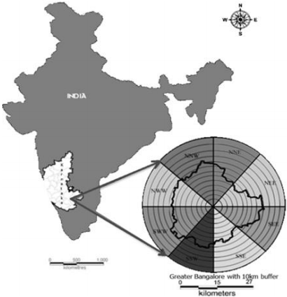
Greater Bangalore with an area of 741 square kilometers and with an altitude of 949 meters above sea level is the administrative capital of Karnataka State, India is located in the Deccan Plateau to the south-eastern part of Karnataka. It lies between the latitudes 12°39’00’’ to 13°13’00’’N and longitude 77°22’00’’ to 77°52’00’’E,. To account for rural-urban gradient, 10 kilometer circular buffer has been considered from the Bangalore administrative (http://www.bbmp.gov.in/) boundary by considering the centroid as City Business District (CBD).


Fig.1 Study area

Bangalore was founded in the year 1537 by then ruler KempeGowda and has eventually evolved into economic hub of Karnataka. Bangalore is accessible by air, road, and rail. The city is well-known for its diverse culture, and history. Greenery with salubrious climate has attracted a large number of investors and migrants from other parts of the country as well as from overseas. Bangalore has grown ten folds spatially from 69 (1949) to 741 square kilometer [35]. Bangalore has been witnessing rapid urbanisation since 1990’s, which has resulted in fundamental land use changes. 632% increase in built-up has resulted in the loss of 76% vegetation and 78% water bodies during the last four decades. These large scale landscape changes has influenced the local climate and has aided in regular floods, Bangalore has been experiencing changes in the temperature leading to urban heat islands [36].

BACK  «  TOP  »  NEXT
Citation : Ramachandra. T.V., Bharath Setturu and Bharath H. Aithal., 2012. Peri-Urban to Urban Landscape Patterns Elucidation through Spatial Metrics, International Journal of Engineering Research and Development. Volume 2, Issue 12 (August 2012), pp. 58-81.
* Corresponding Author :
  Dr. T.V. Ramachandra
Energy & Wetlands Research Group, Centre for Ecological Sciences, Indian Institute of Science, Bangalore – 560 012, India.
Tel : 91-80-23600985 / 22932506 / 22933099,      Fax : 91-80-23601428 / 23600085 / 23600683 [CES-TVR]
E-mail : cestvr@ces.iisc.ernet.in, energy@ces.iisc.ernet.in,     Web : http://wgbis.ces.iisc.ernet.in/energy, http://ces.iisc.ernet.in/grass
E-mail    |    Sahyadri    |    ENVIS    |    GRASS    |    Energy    |      CES      |      CST      |    CiSTUP    |      IISc      |    E-mail