3.3. MANGROVE SITUATION: RANGEWISE
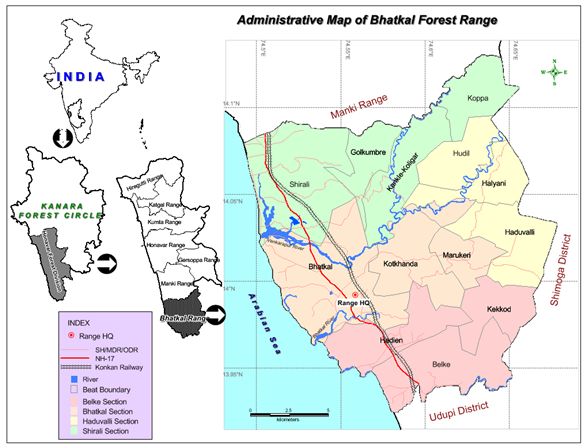
Mangroves of Bhatkal forest range
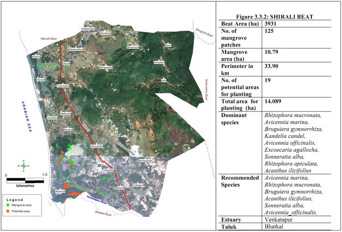
Bhatkal rangein the southernmost part of Honavar forest division (74°29’33.324” to 74°40’41.7792 E long. and 13°55’27.9192 to 14°7’49.512 N lat.) and extends over an area of 27,990 ha(16.47% division). Range has its headquarters in Bhatkal town and covers 61 revenue villages of Bhatkaltalukaare under its jurisdiction. Range is administratively divided in to 5 forest section and 15 beats (Figure 3.3.1). Range is having 73.99 percent of forest area; most forests are basically evergreen. The coastline is 23.84 km. long and includes an island. Major estuary is Venkatapur, (184.6ha). It has small creeks namely Jali creek (7.53h) and Bhatkal creek (45.43 h) Mundalli creek, Hadeen creek and Belke creek (10 h). Mangroves are found mainly inShirali beat of Shirali section, Bhatkal beat of Bhatkal section; and very little areas Hadeen and Belke beats of Belke section. Beat wise detail mangrove area, species and potential area are given in Figures (3.3.2-3.3.3)
Figure 3.3.1 : Administrative map of Bhatkal Forest Range

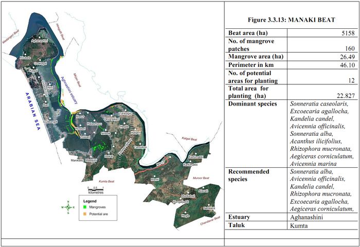
Mangroves of Manki Range
Figure 3.3.4: Administrative map of Manki Forest Range
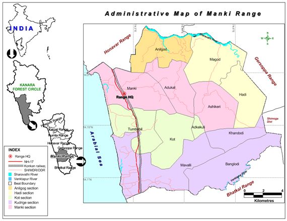
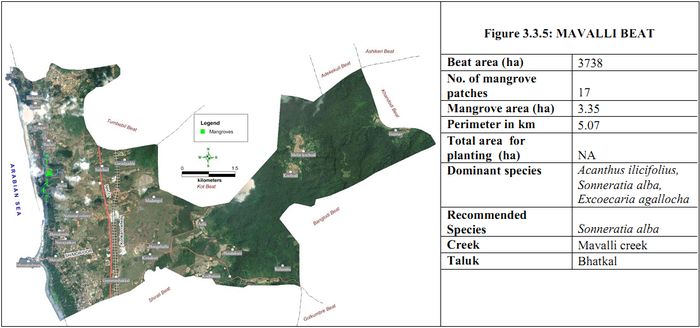
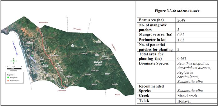
Manki range is located in the South-westregion of Honavar forest division. It lies between 74°27’16.502” to 74°38’43.221 east longitude and 13°04’46.562to 14°14’40.396north latitude and extends over an area of 23870 hectares which is 14.04% of the total area of the division. Range headquarters is in Manki village of Honavartaluka and covers 25 revenue villages of the taluk.and 3 villages of Bhatkaltaluka comes under its jurisdiction. Range is administratively divided in to 5 forest section and 12 beats. Land use in this range has80.36 percent of forest land which is evergreen to semi-evergreen.Range is bordered by Gersoppa Range &Shimoga district at eastern side, Honavar Range at north,Bhatkal Range at south and Arabian Sea to the west, The coast line is 15.75 km long.Important beaches are Manki beach, Bailur beach and Murdeshwar beaches.Range covers 70.55 hectare of estuarine part of Sharavathi River with degraded mangroves due to high fluctuation/variation in salinity because of Sharavathi Tailrace hydroelectric power generation;these degraded Mangrove are found in Anilgod beat of Anilgod section and Magod beat of Hadi section. Creeks areManki creek (19.63h), Mavallicreek (17.8 h) and Bailur creek. Mangroves are found in Manki andMavallibeat. Beat wise detail mangrove area, species and potential area are given below (Figure 3.3.5 and 3.3.6)
Mangroves of Honavar Range
Figure 3.3.7. Administrative map of Honavar Forest Range
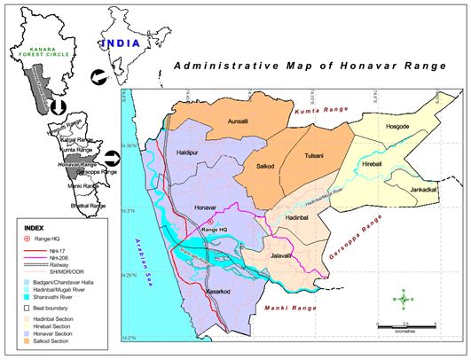
Honavarrange is located in the central west of Honavar forest division. It lies between 74° 24' 34.494"” to 74° 39' 43.772" E and 14° 11' 58.482" to 14° 23' 23.520" N and extends over an area of 31660 hectare which is 18.63 percent of the total area of the division. Range headquarters is in Honavar town and covers 52 revenue villages of Honavartaluka. Range is administratively divided in to 4 forest section and 11 beats.
Land use in this range is 61.81 percent of forest land which is more or less evergreen. Range is bordered by Gersoppa range and Kyadgirange(Sirsi division) towards eastern, Kumta range to north,Manki range to south and Arabian Sea to west. The coastline has a length of 18.06 km. Important beaches are at Kasarkod and Haldipur beach. An islandBasavarajdurg occurs close to the mouth of river Sharavathi.Major estuary is Sharavathi –Badganiesturine complex;2240 ha in areaout of this 3043 hectares of estuarine complexfalls in Honavar Range. Creeks: Apsarkondai creek (1.3h)
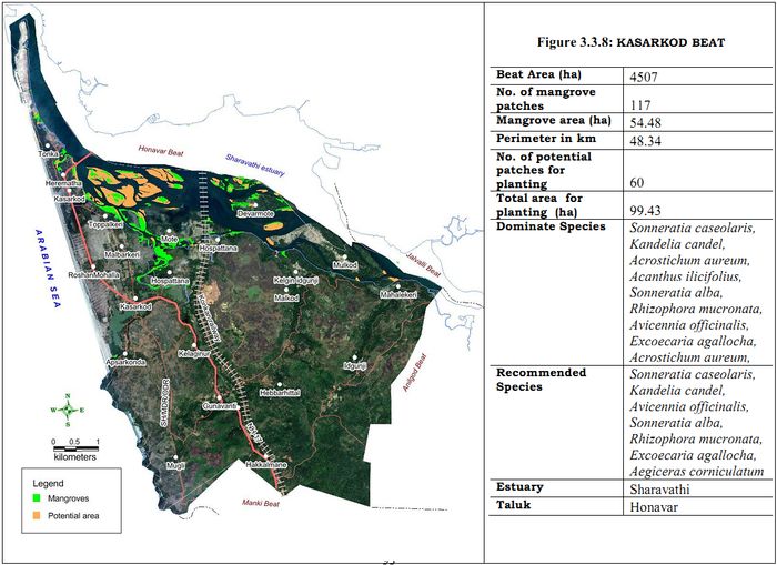
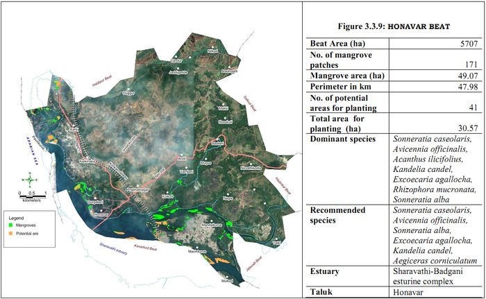
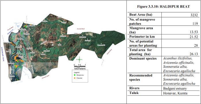
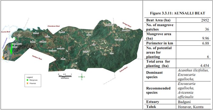
Mangroves are found in Kasarkod, Honavar and Haldipur beats of Honavar section, Aunsalli beat of Salkod section and Hadinbal and Jalvalli beats of Hadinbal section. Beat wise detail mangrove area, species and potential area are given in Figures 3.3.8-3.3.11.
Mangroves of KumtaForest Range
Figure 3.3.12. Administrative map of Kumta Forest Range
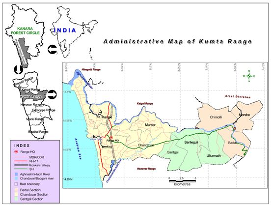
Kumta range is located in the cenral part of Honavar forest division. It lies between 74° 21' 1.230" to 74° 41' 49.074" east longitude and 14° 20' 36.805" to 14° 32' 8.794" north latitude and extends over an area of 30,730 hectare which is 18.08% of the total area of the division. Range headquarters is in Kumta town and covers 59 revenue villages of Kumta taluk and 4 villages of Honavar taluk. Range is administratively divided in to 3 forest sections and 10 beats. Range is having 66.97 percent of forest land which is evergreen to semi-evergreen and secondary deciduous. This range is bordered by Kyadagi range of Sirsi division to the eastern, Katgal, Hiregutti and Janmane ranges to north, Honavar range to south and Arabian Sea to west. The coastline is of 23.25 km long. Important beaches are at Dhareshwar, Kumta and Baad.
Range covers 1,466 hectares of estuary in part of Aghanashini river estuary out of its total waterspread of 4,950 ha, and255 ha of Badagini estuarine region
Creeks: Kumta creek (238 ha) and Dhareshwar creek (4ha)
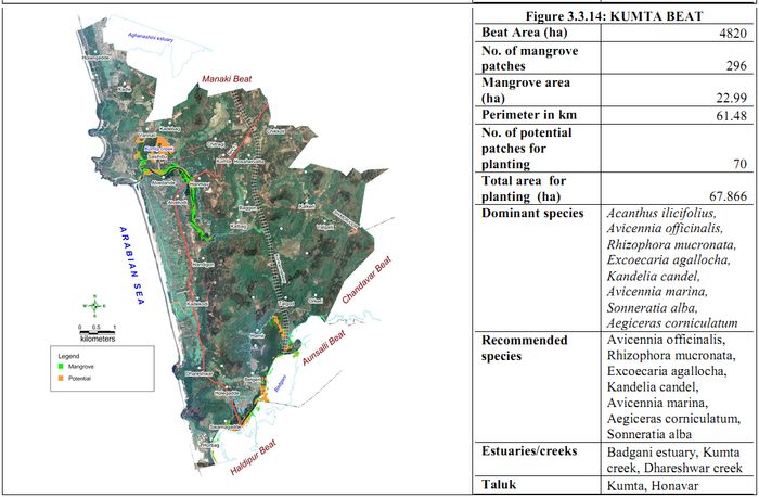
Mangroves are found in Kumta, Manaki and Chandavar beats of Chandavar section. Beat wise detail mangrove area, species and potential area are presented in Figures 3.3.13-3.3.14.
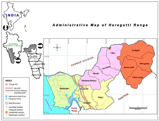
Mangroves of Katgal Forest Range
Figure 3.3.15. Administrative map of Katgal Forest Range
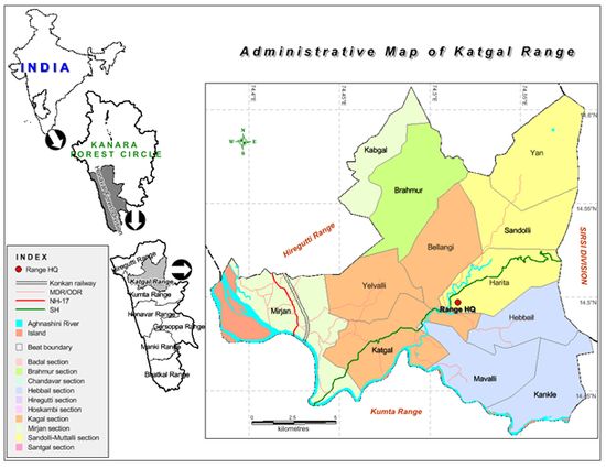
Katgal range is located in the North-east part of Honavar forest division. It lies between 74° 22' 43.540"to 74° 35' 24.535" east longitude and 14° 25' 34.322" to 14° 36' 44.207" north latitude and extends over an area of 24360 hectare which is 14.33 percent of the total area of the division. Range had its headquarters in Katgal hamlet of Antarvalli village of Kumta Taluk and covers 36 revenue villages of Kumta taluk and 2 villages of Ankola taluk came under its jurisdiction. Range is administratively divided in to 3 forest section and 12 beats. The land use in this range is 81.83 percent of forest land which is moreover evergreen. Range is bordered by Janmane range of Sirsi division at Eastern side, Heregutti range at North side Kumta range surrounds at south and West, It covers many estuarine island of Aghanashini.
About 1158 hectare of water spread area of Aghanashini estuarine region fall in this range(4950 h).
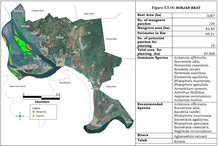
Mangroves are found in Mirjan and Katgal beats of Katgalsection . Beat wise detail mangrove area, species and potential area are given in Figure 3.3.16.
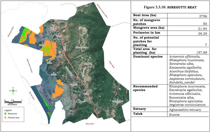
Mangroves of Hiregutti Forest Range
Figure 3.3.17. Administrative map of Hiregutti Forest Range
Hiregutti range is located in the North part of Honavar forest division. It lies between long. 74° 17' 31.828" to 74° 34' 52.728"E and lat. 14° 30' 32.354" to 14° 41' 20.506" N and extends over an area of 31,360 hectare which is 18.45 percent of the total area of the division. Range has its headquarters in Hiregutti village of KumtaTaluk and covers 28 revenue villages of the taluk and 20 villages of Ankolataluk. Range is administratively divided in to 4 forest section and 11 beats. The land use in this range is 65.87% forest land which cover evergreen to semievergreen and secondary moist deciduous type forests.
Range is bordered by Janmane range of Sirsi division at Eastern side, Ankola and Mastikatta ranges of Karwar forest division to north side Kargal and Kumta ranges to south and Arabian Sea to west. The coastline is 16.19 km. long. Important beaches are Gokarna beach, Ombeach, Kudle beach and Nadumaskeri beach.Range covers 330.7ha water spread area of Gangavaliestuary out of its 769.7haand 2326 ha of Aghanashiniestuary, out of its 4950ha total area. This range is by far most important for mangroves. Beat-wise detail mangrove area, species and potential area are given in Figures 3.3.18-3.3.20.