3.2. ESTUARY-WISE MANGROVE SITUATION INHONAVAR FOREST DIVISION
Mangrove vegetation is found associated with the estuaries and creeks of the Division. Obviously, before any kind of agricultural interventions by humans, over 3000 years ago, mangrove vegetation, expectedly, would have been intactin all suitable habitats. With the introduction of agriculture good portions of shallow estuarine areas were reclaimed by preparing earthen embankments to protect large stretches shallow estuarine portions for raising salinity tolerant rice varieties like Kagga. Cleared of mangroves these estuarine fields or ‘gaznis’ were cultivated with Kagga variety of riceespecially during the rainy season, when the fields get flooded and salinity levels decline substantially. The farmers also adopted the practice of planting rows of mangrove trees, just outside these bunds to fortify them from collapse. After the harvest of rice towards the end of the rainy season the bunds were opened to allow the tidal waters inside, through sluice gates, and fisher-folks were allowed to fish in the ‘kodis’ or tidal channels within these gaznis.
This traditional system of estuarine cultivation with mangrove planting was a sustainable system. Maintenance of some patches of mangrove forests as sacred, as in the Masurkurve island in the Aghanashini estuary, dedicated the deity Babrudevaru, is a notable example of traditional conservation. This traditional system suffered a severe setback with the replacement of earthen embankments for gazni fields with permanent stone bunds, beginning in 1960’s. As these bunds are stronger the farmers felt no need to fortify them further with planting of mangroves alongside. On the contrary, in many places the existing mangroves were cut down or domestic use. Moreover the arrival of prawn farming from early 1980’s caused all suitable portions of estuaries getting converted into shrimp ponds, after clearing every trace of woody vegetation. This was quite devastating on the estuarine ecosystem as a whole.
A realization on the importance of mangrove vegetation dawned during the late 1980’s, and the Government, some institutes like the Indian Institute of Science and NGO’s like Snehakunja, Kasarkod, entered the arena for spreading awareness on mangroves and attempting planting in sample plots, especially in Aghanashini estuary. But it was through systematic programmes of mangrove planting by the Forest Department, beginning in late 1990’s, that estuaries started turning greener with mangroves. The formation of village forest committees in estuarine villages promoted peoples’ involvement and better protection was afforded to the mangroves. When the present survey was undertaken to map the mangroves of Honavar Forest Division, under sponsorship of the Karnataka Forest Department, much progress was already achieved in raising of mangrove plantations. An estuary-wise status of mangroves is presented in this chapter.
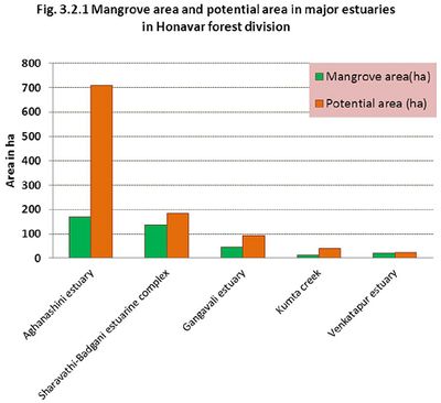
Estuary and creek-wise mangrove areas and potential areas: Through field surveys using GPS and remote sensing imageries (Google Earth and IRS) we mapped mangrove areas available in the division estuary and creek-wise. Among the estuaries Aghanashini topped the list with 169 ha of mangroves and 711 ha of potential area followed by Sharavathi-Badgani estuarine complex (136 ha and 184 ha respectively)-Table 3.2.1 and Figure 3.2.1 for details.Creeks are small but nevertheless should not be ignored.
Table 3.2.1:. Estuary and creek-wise details of mangrove area and potential area
| Sn |
Estuaryname |
Mangrove area(ha) |
Potential area (ha) |
Total water spread Area (ha) |
| 1 |
Gangavali estuary, |
45.93 |
95.29 |
817.10 |
| 2 |
Aghanashini estuary |
169.40 |
711.00 |
5236.00 |
| 3 |
Kumta creek |
14.23 |
42.42 |
238.10 |
| 4 |
Dhareshwar creek |
1.43 |
2.57 |
4.02 |
| 5 |
Sharavathi-Badgani estuarine complex |
136.20 |
184.40 |
3415.00 |
| 6 |
Apsarkonda creek |
0.14 |
0.00 |
1.30 |
| 7 |
Manki creek |
0.62 |
0.47 |
21.63 |
| 8 |
Mavalli creek |
3.06 |
0.00 |
17.80 |
| 9 |
Murudeshwar creek |
0.37 |
0.00 |
35.37 |
| 10 |
Venkatapur estuary |
20.54 |
22.77 |
219.20 |
| 11 |
Jali creek |
0.02 |
0.00 |
5.40 |
| 12 |
Bhatkal creek |
1.69 |
0.00 |
53.22 |
| 13 |
Huvilmadi creek(Hadeen Creek) |
0.10 |
0.00 |
13.71 |
| 14 |
Belke creek |
0.12 |
0.00 |
5.97 |
Mangroves in relation to salinity: Mangroves have different preferences for salinity levels. During the rainy seasons all mangroves can survive extremely low salinities approaching almost the levels of fresh water conditions. It is the dry season salinity that is decisive for mangrove distribution within an estuary. Estuarine salinity, in natural state is between that of sea water (normally 35 ppt) and fresh water (<0.5 ppt). The salinity keeps fluctuating with tides and seasons. In normal conditions salinity increases towards the river mouth approaching nearly sea water salinity and lowers progressively in upstream areas where the river water meets the salt water tides. Mangroves, broadly can be classified into high salinity (>15 ppt) tolerant, medium salinity (5-15 ppt) tolerant and low salinity (<5 ppt) tolerant. The details of such mangroves present in the Honavar Division are given in Table 3.2.2.
Table:3.2.2: Mangrove species in relation to different salinity ranges
| Mangroves sp. |
> 15 ppt
(High salinity) |
5-15 ppt
(Medium salinity) |
< 5 ppt
(Low salinity) |
| Acanthus ilicifolius |
+ |
+ |
+ |
| Acrostichum aureum |
|
|
+ |
| Aegiceras corniculatum |
|
+ |
|
| Avicennia marina |
+ |
|
|
| Avicennia officinalis |
+ |
+ |
|
| Bruguiera gymnorrhiza |
|
+ |
|
| Excoecaria agallocha |
+ |
+ |
|
| Kandelia candel |
+ |
+ |
|
| Rhizophora apiculata |
+ |
|
|
| Rhizophora mucronata |
+ |
+ |
|
| Sonneratia alba |
+ |
+ |
|
| Sonneratia caseolaris |
|
+ |
+ |
A. MANGROVES OF GANGAVALI ESTUARY
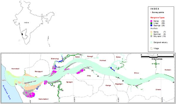
The Gangavali or Bedti River forms the northern boundary of Honavar Forest Division, along the coast (Figure 3.2.2),A narrow range of hills separate Gangavali basin from that of Aghanashini further south. The river has its origin in two streams in the Dharwad district namely Shalmala and Bedti. These two join near Kalghatgi (Dharwad dist) and flow towards Uttara Kannada as Bedti River, known as Gangavali in the coast. It has a total length of 161 km, out of which 96 km lies in Uttara Kannada. The sea water moves in the Gangavali River for almost a distance of 24 km upstream to the village Gundbala. The river has 571 ha of estuarine water spread area and 3 small islands. The mangroves of Gangavali mostly belong to the fringe type and occur alongside the tidal part of the river in linear patches. Some denser mangrove habitats are found in the villages Nadumaskeri (Gangavali), Agragon, Hadav, Joog, and Ulware. Dense mangroves, linear mangroves and sapling areas (recently planted) are also shown in the figure.
Waterscape/landscape elements: Of the 571 ha of estuarine area about 13 hatowards the river mouth is covered with sand bars and sandy shores. The mud-flats of the estuary cover around 75.55 ha. The mud flats are submerged during high tides. Mud flats may be sandy, of sandy silt or silty sand. They are very productive areas and especially the sand mixed mud flats support the molluscan fisheries of great value to the local communities. The sandy flats are not suitable for mangroves. Those parts with finer silts covering around 39.5 ha and are the only areas suitable for mangrove afforestation. The mangrove vegetation as such cover about 41.6 ha. The mangrove patches, in general, have an estimated 428 trees/ha (as inferred from point-centered quarter and 10x10 m quadrats). Mud flats are often subjected to variations in their morphology and extent depending on the annual floods and silt deposits. Natural succession of mangroves may be expected in some of the mud flats (Table-3.2.3and Figure-3.2.2also shows sediment nature)
Table 3.2.3: Characterisation of waterscape/landscape elements of Gangavali estuary
| |
Elements |
Sub elements |
Area in ha |
Suitability for planting |
| A |
Sandbar/deposits |
- |
12.84 |
Mangrove associates may be planted |
| B |
Mudflat
(75.55ha) |
Sandy |
5.33 |
Part of ecosystem- no planting recommended |
| Bivalve beds |
30.67 |
No planting recommended |
| Potentialfor mangrove planting |
59.29 |
Mangroves recommended |
| C |
Existing Mangrove area |
- |
45.92 |
|
| Total water spread area* |
B+C+open water area+salt pans etc |
817.1 |
|
*The waterspread area includes the entire estuary which gets covered during high tide
Figure 3.2.2: Gangavali estuary showing mangrove areas, bottom sediment nature
Mangroves and potential mangrove areas - village-wise distribution: Details regarding existing mangrove areas adjoining the villages of the estuarine complex including estimated tree density/ha and potential area available for planting with mangroves are furnished in Table-3.2.3. Out of the 13 villages bordering the estuary only Nadumaskeri, which has the largest area under mangroves (18.57 ha) falls in Kumta taluk. Nadumaskeri also has the highest potential area (17.24 ha) suitable for mangrove planting. The other villages which have lesser area under mangroves and also for planting, come under the Ankola taluk(Table-3.2.4and Figure-3.2.1.2). The tree density of these is reasonably good although the tree statures are not good, almost all less than 8 m in height. The survey points are numbered in the figure. Village-wise area under mangroves along with tree density and area suitable for planting are shown in Table-3.2.4.
Table 3.2.4: Village-wise details of mangrove area, tree density and potential area available for planting in Gangavali estuary
| Sn |
Village |
Taluk |
Mangrove area in ha. |
Tree density per ha.* |
Potential area available for planting (ha) |
| 1 |
Nadumaskeri |
Kumta |
17.24 |
433 |
18.57 |
| 2 |
Agragon |
Ankola |
2.45 |
383 |
2.86 |
| 3 |
Belse |
Ankola |
0.07 |
|
nil |
| 4 |
Bilehoingi |
Ankola |
11.05 |
506 |
4.01 |
| 5 |
Hadav |
Ankola |
1.70 |
644 |
5.16 |
| 6 |
Hichkad |
Ankola |
0.05 |
|
nil |
| 7 |
Honnebail |
Ankola |
0.09 |
|
nil |
| 8 |
Joog |
Ankola |
4.73 |
309 |
4.97 |
| 9 |
Kodsani |
Ankola |
0.45 |
|
nil |
| 10 |
Manjaguni |
Ankola |
0.09 |
|
2.04 |
| 11 |
Sagadgeri |
Ankola |
0.33 |
300 |
nil |
| 12 |
Shirur |
Ankola |
2.31 |
460 |
1.96 |
| 13 |
Ulware |
Ankola |
1.09 |
367 |
nil |
Mangroves: patches and linear formations: Mangroves may occur in patches of high density or may be linear formations fringing the estuary and its inlets. For both these formations we have estimated tree density/ha of mangroves. Tree density has increased in recent years on account of high density planting (Table-3.2.5 & Figure-3.2.2)
Table 3.2.5: Details of village-wise mangrove area and estimated tree and sapling density/ha
| Sn |
Village |
Taluk |
Patch mangrove |
Linear mangrove |
Mangrove saplings |
| Area (ha) |
Tree Density/ ha* |
Area (ha) |
Tree density/ ha* |
Area ha. |
Density/ ha.* |
| 1 |
Nadumaskeri |
Kumta |
12.77 |
498 |
2.46 |
200 |
2.02 |
463 |
| 2 |
Agragon |
Ankola |
0.35 |
500 |
1.31 |
433 |
0.79 |
328 |
| 3 |
Belse |
Ankola |
|
|
0.07 |
|
|
|
| 4 |
Bilehoingi |
Ankola |
5.28 |
492 |
1.97 |
622 |
3.80 |
405 |
| 5 |
Hadav |
Ankola |
0.85 |
488 |
0.85 |
800 |
|
|
| 6 |
Hichkad |
Ankola |
|
|
0.05 |
|
|
|
| 7 |
Honnebail |
Ankola |
|
|
0.09 |
|
|
|
| 8 |
Joog |
Ankola |
4.26 |
396 |
0.33 |
275 |
0.13 |
300 |
| 9 |
Kodsani |
Ankola |
|
|
0.45 |
|
|
|
| 10 |
Manjaguni |
Ankola |
|
|
0.09 |
|
|
|
| 11 |
Sagadgeri |
Ankola |
|
|
0.27 |
400 |
0.07 |
200 |
| 12 |
Shirur |
Ankola |
|
|
0.87 |
|
1.43 |
460 |
| 13 |
Ulware |
Ankola |
0.22 |
500 |
0.73 |
200 |
0.14 |
400 |
| Total |
41.65 |
478.90 |
23.72 |
419 |
9.54 |
365 |
Mangrove sample study localities and species: Mangroves (both patch and linear) were studied in 43 localities within the estuary as perdetails given in Table-3.2.6. The eumangroves or true mangroves found were Avicennia marina, A. officinalis, Excoecaria agallocha, Kandelia candel, R. apiculata, R. mucronata and Sonneratia alba. Acanthus ilicifolius is a gregariously growing mangrove undershrub. It forms larger patches in silted and stagnant water areas along the estuarine belt. Acrostichum aureum is a fern especially found in lesser saline, water stagnant areas. Some of the mud flats towards the estuarine mouth had formations of high salinity tolerant grass Porteresia coarctata, a close relative of rice plant.
Table3.2.6:Sample study details, habitat type, area, tree density and dominant species
| Sn |
Long. |
Lat. |
Village |
Taluk |
Patch/linear |
Area (ha) |
Tree density/ ha.* |
Dominant sp. (including shrubs) |
| 1 |
74.2966 |
14.5921 |
Nadumaskeri |
Kumta |
Patch |
0.11 |
100 |
Sonneratia alba, Avicennia marina |
| 2 |
74.2983 |
14.5907 |
Nadumaskeri |
Kumta |
Patch |
0.27 |
533 |
S. alba |
| 3 |
74.2988 |
14.5927 |
Nadumaskeri |
Kumta |
Patch |
1.15 |
786 |
S. alba |
| 4 |
74.2990 |
14.5906 |
Nadumaskeri |
Kumta |
Patch |
0.98 |
557 |
S. alba, Rhizophora mucronata, A. marina |
| 5 |
74.2998 |
14.5904 |
Nadumaskeri |
Kumta |
Patch |
0.20 |
500 |
S. alba, R. mucronata, A. marina |
| 6 |
74.3005 |
14.5902 |
Nadumaskeri |
Kumta |
Patch |
0.34 |
500 |
S. alba, R. mucronata, A. marina |
| 7 |
74.3013 |
14.5918 |
Nadumaskeri |
Kumta |
Patch |
6.71 |
600 |
R. mucronata, S. alba, A. marina |
| 8 |
74.3014 |
14.5903 |
Nadumaskeri |
Kumta |
Patch |
0.37 |
567 |
S. alba, R. mucronata, A. marina |
| 9 |
74.3093 |
14.5982 |
Nadumaskeri |
Kumta |
Patch |
2.21 |
340 |
Avicennia officinalis, Excoecaria agallocha, A. marina, R. mucronata |
| 10 |
74.3140 |
14.5964 |
Nadumaskeri |
Kumta |
Linear |
0.36 |
400 |
E. agallocha, A. marina, Acanthus ilicifolius |
| 11 |
74.3164 |
14.5939 |
Nadumaskeri |
Kumta |
Linear |
0.60 |
100 |
E. agallocha, A. officinalis, A. ilicifolius |
| 12 |
74.3170 |
14.5898 |
Nadumaskeri |
Kumta |
Linear |
0.22 |
100 |
E. agallocha, A. officinalis, A. ilicifolius |
| 13 |
74.2924 |
14.5973 |
Nadumaskeri |
Kumta |
Saplings |
0.52 |
400 |
E. agallocha |
| 14 |
74.3003 |
14.5923 |
Nadumaskeri |
Kumta |
Saplings |
0.27 |
200 |
S. alba, E. agallocha |
| 15 |
74.3044 |
14.5953 |
Nadumaskeri |
Kumta |
Saplings |
0.60 |
700 |
A. marina, R. mucronata |
| 16 |
74.3045 |
14.5947 |
Nadumaskeri |
Kumta |
Saplings |
0.20 |
550 |
A. marina |
| 17 |
74.3135 |
14.5986 |
Agragon |
Ankola |
Patch |
0.13 |
500 |
E. agallocha, A. marina, A. ilicifolius |
| 18 |
74.3188 |
14.5940 |
Agragon |
Ankola |
Linear |
1.12 |
433 |
A. officinalis, A. ilicifolius, E. agallocha, Kandelia kandel |
| 19 |
74.3148 |
14.5989 |
Agragon |
Ankola |
Saplings |
0.32 |
250 |
R. mucronata, A. marina |
| 20 |
74.3155 |
14.5992 |
Agragon |
Ankola |
Saplings |
0.14 |
100 |
R. mucronata, A. marina |
| 21 |
74.3161 |
14.5992 |
Agragon |
Ankola |
Saplings |
0.34 |
633 |
R. mucronata, A. marina |
| 22 |
74.3134 |
14.6066 |
Bilehoingi |
Ankola |
Patch |
0.49 |
380 |
K. candel, A. officinalis, R. mucronata, E.agallocha |
| 23 |
74.3139 |
14.6037 |
Bilehoingi |
Ankola |
Patch |
3.93 |
595 |
A. officinalis, A. marina, E. agallocha, A. ilicifolius |
| 24 |
74.3143 |
14.6063 |
Bilehoingi |
Ankola |
Patch |
0.86 |
500 |
K. candel, A. officinalis, R. mucronata, E. agallocha |
| 25 |
74.3192 |
14.6101 |
Bilehoingi |
Ankola |
Linear |
0.53 |
567 |
K. candel, A. officinalis, R. mucronata, E. agallocha |
| 26 |
74.3205 |
14.6118 |
Bilehoingi |
Ankola |
Linear |
0.41 |
700 |
A. officinalis, A. marina |
| 27 |
74.3216 |
14.6130 |
Bilehoingi |
Ankola |
Linear |
0.37 |
600 |
A. officinalis, A. marina |
| 28 |
74.3149 |
14.6069 |
Bilehoingi |
Ankola |
Saplings |
1.82 |
330 |
K. candel, A. officinalis, R. mucronata, E. agallocha |
| 29 |
74.3168 |
14.6068 |
Bilehoingi |
Ankola |
Saplings |
0.40 |
200 |
K. candel, A. officinalis, R. mucronata, E. agallocha |
| 30 |
74.3191 |
14.6114 |
Bilehoingi |
Ankola |
Saplings |
1.58 |
686 |
K. candel, A. officinalis, R. mucronata, E. agallocha |
| 31 |
74.3215 |
14.6056 |
Hadav |
Ankola |
Patch |
0.85 |
488 |
A. officinalis |
| 32 |
74.3290 |
14.6137 |
Hadav |
Ankola |
Linear |
0.71 |
800 |
A. officinalis, A. marina |
| 33 |
74.3290 |
14.6044 |
Joog |
Ankola |
Patch |
4.26 |
396 |
K. candel, A. officinalis, R. mucronata, E. agallocha |
| 34 |
74.3335 |
14.6065 |
Joog |
Ankola |
Linear |
0.18 |
350 |
A. officinalis |
| 35 |
74.3390 |
14.6019 |
Joog |
Ankola |
Linear |
0.07 |
200 |
E. agallocha, A. officinalis |
| 36 |
74.3312 |
14.6052 |
Joog |
Ankola |
Saplings |
0.05 |
100 |
A. officinalis |
| 37 |
74.3359 |
14.6050 |
Joog |
Ankola |
Saplings |
0.08 |
500 |
A. officinalis |
| 38 |
74.3506 |
14.6009 |
Sagadegeri |
Ankola |
Linear |
0.27 |
400 |
E. agallocha, A. ilicifolius, A. officinalis |
| 39 |
74.3533 |
14.5993 |
Sagadegeri |
Ankola |
Saplings |
0.07 |
200 |
A. officinalis |
| 40 |
74.3474 |
14.6057 |
Shirur |
Ankola |
Saplings |
1.43 |
460 |
A. officinalis |
| 41 |
74.3616 |
14.5966 |
Ulware |
Ankola |
Patch |
0.22 |
500 |
E. agallocha, A. officinalis |
| 42 |
74.3620 |
14.5969 |
Ulware |
Ankola |
Linear |
0.14 |
200 |
E. agallocha, A. officinalis |
| 43 |
74.3822 |
14.5983 |
Ulware |
Ankola |
Saplings |
0.09 |
400 |
A. officinalis |
Recommendations for mangrove planting
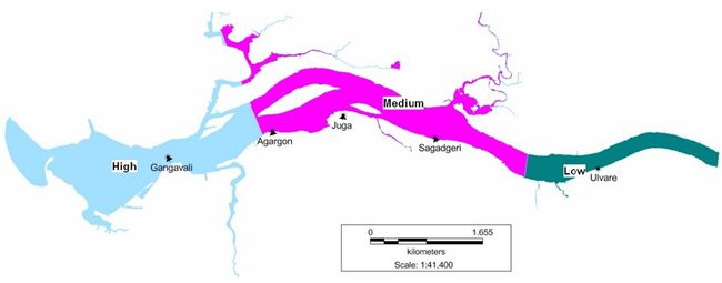
High salinity tolerance is exhibited by Sonneratia alba, Avicennia marina and Rhizophora spp. A. officinalis grows in medium salinity areas. Kandelia candel is found in medium and low salinity areas. Excoecaria agallocha can tolerate a wide range of salinity. We reaffirm that the mudflats that support bivalves (mollusca), as indicated in Table-5 are to be excluded from any disturbance as they are of tremendous economic importance to the local communities and also of high ecosystem value. Table-3.2.7in combination with Figure-3.2.3 will provide a clear picture of the mangrove tree species that can be raised in different localities. Salinity zones (high, medium and low) are demarcated in Figure 3.2.4 and species for high, medium and low salinity zones recommended are given in Table 3.2.8.
Table: 3.2.7. Village-wise potential area for mangrove planting and location-wise recommended species for planting in Gagavali estuary
| Sl.No. |
Longitude |
Latitude |
Village |
Taluk |
Type of Sediment |
Area in Ha. |
Preferable Mangrove |
| 1 |
74.2945 |
14.5983 |
Nadumaskeri |
Kumta |
Sand |
2.88 |
Mangrove associates |
| 2 |
74.2963 |
14.5988 |
Nadumaskeri |
Kumta |
Sand |
0.68 |
-do- |
| 3 |
74.2967 |
14.5979 |
Nadumaskeri |
Kumta |
Sand |
1.08 |
-do- |
| 4 |
74.3021 |
14.5963 |
Nadumaskeri |
Kumta |
Sandy |
24.34 |
Bivalve Bed – all bivalve beds to be excluded |
| 5 |
74.2914 |
14.5983 |
Nadumaskeri |
Kumta |
Sand bar |
2.42 |
Mangrove associates |
| 6 |
74.2924 |
14.5980 |
Nadumaskeri |
Kumta |
Sand bar |
2.53 |
-do- |
| 7 |
74.2974 |
14.5933 |
Nadumaskeri |
Kumta |
Sandy silt |
6.64 |
S.alba, R. mucrinata, A.marina, K.candel |
| 8 |
74.3043 |
14.5945 |
Nadumaskeri |
Kumta |
Sandy silt |
9.71 |
S.alba, A.marina, E.agallocha, R.apiculata |
| 9 |
74.3142 |
14.5981 |
Nadumaskeri |
Kumta |
Sandy silt |
2.22 |
E. agallocha, A. officinalis, K. candel |
| 10 |
74.3142 |
14.5988 |
Agragon |
Ankola |
Sandy silt |
2.14 |
A. officinalis, R. mucronata |
| 11 |
74.3177 |
14.6005 |
Agragon |
Ankola |
Sandy silt |
0.67 |
A. officinalis, R.mucronata, K.candel |
| 12 |
74.3221 |
14.6033 |
Agragon |
Ankola |
Sandy silt |
0.05 |
R. mucrinata, A. officinalis, K. candel |
| 13 |
74.3125 |
14.6029 |
Bilehoingi |
Ankola |
Sandy silt |
0.03 |
R. mucrinata, A.officinalis, K.candel |
| 14 |
74.3135 |
14.6063 |
Bilehoingi |
Ankola |
Sandy silt |
0.62 |
R. mucrinata, A.officinalis, K.candel |
| 15 |
74.3142 |
14.6072 |
Bilehoingi |
Ankola |
Sandy silt |
0.73 |
A.officinalis, E.agallocha, |
| 16 |
74.3150 |
14.6037 |
Bilehoingi |
Ankola |
Sandy silt |
2.64 |
A.officinalis, E.agallocha, |
| 17 |
74.3206 |
14.6048 |
Hadav |
Ankola |
Sandy silt |
0.88 |
A.officinalis, R.mucronata |
| 18 |
74.3223 |
14.6073 |
Hadav |
Ankola |
Sandy silt |
4.28 |
E.agallocha, A.officinalis, |
| 19 |
74.2966 |
14.6004 |
Honnebail |
Ankola |
Sand |
0.69 |
Mangrove associates |
| 20 |
74.2877 |
14.6037 |
Honnebail |
Ankola |
Sand bar |
2.29 |
Mangrove associates |
| 21 |
74.2895 |
14.6029 |
Honnebail |
Ankola |
Sand bar |
7.27 |
Mangrove associates |
| 22 |
74.2936 |
14.6011 |
Honnebail |
Ankola |
Sand bar |
1.03 |
Mangrove associates |
| 23 |
74.3288 |
14.6049 |
Joog |
Ankola |
Sandy silt |
4.03 |
R. mucrinata, A.officinalis, K. candel |
| 24 |
74.3341 |
14.6061 |
Joog |
Ankola |
Sandy silt |
0.11 |
R. mucrinata, A.officinalis, K. candel |
| 25 |
74.3353 |
14.6068 |
Joog |
Ankola |
Sandy silt |
0.82 |
R. mucrinata, A.officinalis, K. candel |
| 26 |
74.2985 |
14.6029 |
Manjaguni |
Ankola |
Sand |
6.33 |
Bivalve Bed |
| 27 |
74.3042 |
14.6012 |
Manjaguni |
Ankola |
Sand |
0.58 |
Mangrove associates |
| 28 |
74.3116 |
14.6029 |
Manjaguni |
Ankola |
Sandy silt |
2.04 |
A.officinalis, E.agallocha, |
| 29 |
74.3474 |
14.6056 |
Shirur |
Ankola |
Sandy silt |
1.43 |
E.agallocha, A.officinalis, |
| 30 |
74.3476 |
14.6083 |
Shirur |
Ankola |
Sandy silt |
0.06 |
E.agallocha, A.officinalis, |
| 31 |
74.3495 |
14.6063 |
Shirur |
Ankola |
Sandy silt |
0.47 |
E.agallocha, A.officinalis, |
Table 3.2.8:Mangrovesrecommended for planting in potential areas
| Sn |
Mangroves sp. |
Salinity zones |
| High |
Medium |
Low |
| 1 |
Avicennia marina |
√ |
|
|
| 2 |
A. officinalis |
√ |
√ |
|
| 3 |
Excoecaria agallocha |
√ |
√ |
|
| 4 |
Kandelia candel |
√ |
√ |
|
| 6 |
Rhizophora apiculata |
√ |
|
|
| 7 |
R.. mucronata |
|
√ |
|
| 8 |
Sonneratia alba |
√ |
√ |
|
| 9 |
S. caseolaris |
|
|
√ |
Figure 3.2.3: Locations of potential area for planting mangroves and mangrove associates (numbered 1-41)
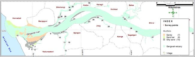
Figure 3.2.4: Salinity zones demarcated in Gangavali estuary
Mangrove associates
The names of plant species that live in association with mangroves, or growing towards the outer drier edges of the swamps, are mangrove associates. They may be present in the inland areas also. The location-wise list of mangrove associates studied is given in the Table 3.2.9.
Table 3.2.9. Location-wise list of mangrove associates and their distribution in selected sample areas of the Gangavali estuary
| Sn |
Name of species |
Gangavali |
Bilihonge |
Uluvare |
Mudnur |
Sagadgeri |
Mogta |
| 1 |
Caesalpinia bonducella* |
+ |
|
|
|
|
|
| 2 |
Caesalpinia crista |
|
|
+ |
|
+ |
+ |
| 3 |
Calotropis gigantea* |
+ |
|
|
|
|
|
| 4 |
Clerodendron inerme |
+ |
+ |
+ |
|
|
|
| 5 |
Cyperus arenarius |
|
|
|
+ |
|
|
| 6 |
Cyperus sp |
+ |
|
+ |
|
|
|
| 7 |
Derris scandens |
|
|
|
|
|
+ |
| 8 |
Derris trifoliata |
|
+ |
+ |
|
+ |
+ |
| 9 |
Erythrina variegata |
|
|
+ |
+ |
|
|
| 10 |
Ficus racemosa |
|
|
+ |
+ |
|
|
| 11 |
Hibiscus tiliaceus |
|
|
|
|
+ |
+ |
| 12 |
Phoenix sp. |
|
|
+ |
|
|
|
| 13 |
Phyllanthus reticulatus |
|
|
|
|
|
+ |
| 14 |
Pongamia pinnata |
|
|
|
|
+ |
+ |
| 15 |
Premna corymbosa |
|
|
|
|
+ |
|
| 16 |
Spinifex littoralis* |
+ |
|
|
|
|
|
| 17 |
Vitex negundo* |
|
|
|
|
|
+ |
| 18 |
Vitex trifolia* |
+ |
|
|
|
|
|
| 19 |
Zizyphus jujube* |
|
|
+ |
|
|
|
* Present only on sand deposits
Some notable mangrove localities
- Nadumaskeri: Situated towards the mouth of the river it has some notablemangrove patches. Mangroves are in very disturbed state, being cut down for local needs and grazing mainly by buffaloes. The patches are dominated by the coppice growth of Sonneratia alba,the average height of the coppice shoots being 2-3 meters. According to some locals during the tsunami of December 2004, the mangrove areas of the river mouth were inundated by sand, thereby affecting the regeneration of most mangroves. But at the time of our study the swampiness had increased, and therefore, under protection mangroves have every chance of good regeneration. Rhizophora apiculataoccurs here although somewhat rare. There is bushy growth of Avicennia marina towards the open outer edges of the swamp. Bushes of Excoecaria agallocha occur towards the bund of the river, on exposed land, where salinity can be very high.Most of the Sonneratiaare coppice from stumps. Cattle-grazing, is common. Seedlings of Rhizophora, planted by the Forest Department, were observed amidst the Sonneratia patch. However, Rhizophora requires more swampy conditions. An erect mangrove grass Porteresia coarctata was found growing in almost pure patches forming meadows in the open shallow parts of the estuary. Notable of the mangrove associates of Gangavali are Vitex trifolia, Spinifex littoralis (both in open sandy places) and Clerodendrum inerme. A rare patch of Caesalpinia bonducella, a medicinal plant was found on the sand dunes of the river mouth.
- Bilihoingi: A very swampy tidal inlet towards the northern bank of Gangavali this is good habitat for mangroves. Most notable were Avicennia marina and A. officinalis. Sparingly were found Sonneratia alba, Excoecaria agallocha and Kandelia candel. Rao and Suresh (2001) reported A. albaas the most dominant species from Bilihonge, which we could not trace however. Derris trifoliata occurs as a mangrove associate. Clerodendrum inerme occurs in sandy exposed parts. The grass Porteresia coractata occurs in open sandy parts of the swamp bordering the river. The Avicennias here attain maximum height of 7 to 8 meters, and most trees have girth less than 1 m. Though there are no nearby habitations, most trees bear marks of cutting of branches. The ground layer is dominated by Acanthus ilicifolius.
- Agragon: A promising patch of mangroves is found in this village. It is dominated by fairly large trees of A. officinalis. These trees have a general height of 8-9 m and many of them have girth nearing 1m or even exceeding it. R. mucronata is the common associate of A. officinalis. Towards the shallower edges are found K. candel, A. marina, S. albaand A. ilicifolius. At least, during the recent years, there appears to be no disturbance of this patch of mangroves.
- Sagadgiri: A small good patch of mangroves occurs along the tidal swamp close to the ferry cross. It was dominated by A. officinalis. The largest tree here had a gbh of 172 cm and height of 12 m. It is followed by K. candel of 6-7 m. The latter occurs regularly all along the shallower edges. Drier part of the river-bank has E. agallocha. Other mangroves wereAegiceras corniculatum (rare), R. mucronata(rare) and A. ilicifolius. Derris trifoliata, Caesalpinia cristata, Hibiscus tiliaceus and Premna corymbosa are climbers associated with mangroves. Occasionally found along the river bank were small trees of Pongamia pinnata. The mangrove grass P. coarctatawas also found.
- Mudnur: Situated on the southern bank of the river this locality is notable for a narrow strip of fringe mangroves and mangrove associates. The mangroves include several small trees of K. candel followed by A. officinalis. Few bushes of A. corniculatum were also found. Of the mangrove associates at higher ground are Erythrina variegata and Ficus racemosa.
- Ulvare: This village situated along the southern bank of Gangavali has narrow strip of fringe mangroves dominated by E. agallocha. This small tree has profuse production of branches from below. It is ideally suited for perching along the steep sides of the river bank. Occasionally found is A. officinalis, one individual of which has attained a remarkable gbh of 210 cm. There are several Ficus racemosa, bearing fruits in various stages of maturity. Others are D. trifoliata, C. inerme, C. cristaand Z. mauritiana. There are evidences of planting of Rhizophora; but most propagules we observed were lifeless, may be due to the presence of the steep embankment and lesser swampiness of the habitat. A. officinalis and K. candelwould thrive here better.
- Mogta: This village situated further away from the coast has some fringe mangroves bordering the bottom of the steep embankments. These include occasional A. officinalis, K. candel and E. agallocha. Higher along the edges of the river are mangrove associates D. trifolia, D. scandens, H. tiliaceus, Vitex negundo, Phyllanthus reticulatus and Pongamia pinnata.There are tell-evidences in this village of natural recolonisation of mangroves in parts of the fields abandoned due to invasion of tidal water. Formerly there was a sluice gate to stop the inundation of salt water through a natural kodi (tidal channel). This sluice gate, reportedly, got damaged several years back causing tidal invasion of the fields, especially during the highest tides of full moon and new moon days. The permanently wetter parts of this narrow creek and its sides are getting colonized by A. officinalis, K. candel, A. corniculatum, R. apiculata, A. ilicifolius and the mangrove fern Acrostichum aureum. The place provides good evidence of how mangrove succession can naturally happen in suitable habitats, if humans do not destroy them.
Spatial mapping using remote sensing data
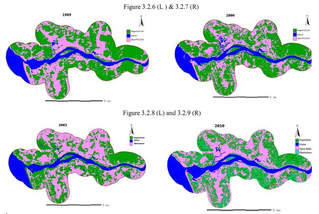
Using IRS p6L4 MX5 M imagery the details of landscape/waterscape elements observed in the estuarine belt as a whole (total waterspread area) are given in the Table 3.2.10. RS imageries of 1989, 2000, 2003 and 2010 depicting changes in land usein the Gangavali estuarine belt, including 1 km buffer zone, are given inTable 3.2.11 andFigures 3.2.6 to 3.2.9 respectively.
Table 3.2.10: Details of area under tree mangroves (for 3 species), other vegetation, in the total waterspread area in the estuary of Gangavali as per IRS p6L4 MX5 M imagery
| Category LSE/WSE |
Area in ha |
% |
| Rhizophora mucronata |
3.010 |
0.46 |
| Sonneratia alba |
1.903 |
0.29 |
| Avicennia_officinalis |
2.088 |
0.32 |
| Other vegetation |
36.465 |
5.58 |
| Open water |
620.996 |
76.6 |
| Estuarine fields |
102.622 |
15.72 |
| Plantations |
6.693 |
1.03 |
| Total area |
817.1 ha |
Figure 3.2.5: Gangavali estuary proper 2010 species-wise tree mangrove distribution based on IRS p6L4 MX5 M imagery
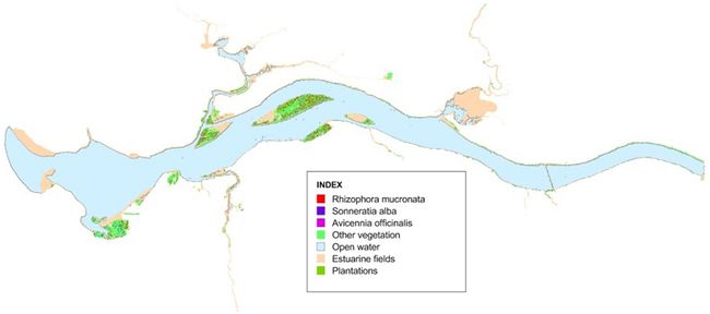
Table 3.2.11: Changes in area under vegetation, waterspread area and fields in the estuary of Gangavali (including 1 km buffer zone) during the year 1989, 2000, 2003 & 2010
Category
Year |
Vegetation |
Water |
Fields |
| ha |
% |
ha |
% |
ha |
% |
| 1989 |
2280.827 |
48.77 |
715.264 |
15.29 |
1680.456 |
35.93 |
| 2000 |
2389.579 |
51.1 |
723.120 |
15.46 |
1563.847 |
33.44 |
| 2003 |
2348.34 |
50.22 |
783.664 |
16.76 |
1544.540 |
33.02 |
| 2010 |
2413.09 |
51.59 |
831.240 |
17.77 |
1432.240 |
30.64 |
| Total area |
4676.55 ha |
Figure 3.2.6-3.2.9. Gangavali estuarine belt (including 1 km buffer zone): transitions in landuse as observed in remote sensing imageries (1989-2010)
B. MANGROVES OF AGHANASHINI ESTUARY
Figure 3.2.10: Aghanashini estuary showing mangroves, salinity zones and potential area for planting
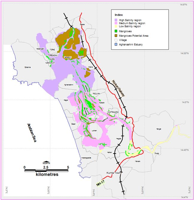
The Aghanashini or Tadri river, 121 km long, originates at Manjuguni near Sirsi in Uttara Kannada Western Ghats. It meets the tide at Uppinpatna in Kumta taluk. Elements of mangrove vegetation begin here and increase in numbers and diversity for the next 24 km of the river’s course. From the village of Mirjan, the river forms a vast expanse of backwaters or estuary that runs parallel to the coast. This estuary is 13 km long and 2 to 6 km broad. The expansive and shallow nature of the estuary and the presence of several mudflats make it ideal habitat for mangroves. The river mouth at Tadri is narrow and situated between 2 hills of Gokarna and Kagal villages.
Mangrove areas and potential areas for planting: Details of village-wise area under mangroves and potential area for mangrove planting are shown in Table 3.2.13. Masurkurve 32 ha and Hiregutti with 23 ha have highest area under mangroves. Hireggutti has 151 ha suitable area for mangrove planting followed by Madanageri with 128 ha.Details of area under high, medium and low salinity areas with mangroves and available for planting are given in Table 3.2.12.With almost 733 ha of potential areas for planting Aghanashini estuary could developed as one of the finest mangrove areas of Karnataka. Details regarding salinity zone-wise recommended mangroves are given in Table 3.2.14. Studying site suitability we have also listed mangrove associates for planting (Table 3.2.15)
Table 3.2.12:Salinity status-wise mangrove area and potential area for planting in Aghanashini estuary
| Salinity level |
Mangrove area in ha |
Potential area in ha. |
Total waterspred area in ha. |
| High |
29.25 |
675.3 |
2794 |
| Medium |
88.91 |
57.2 |
1910 |
| Low |
1.2 |
0 |
236.7 |
| Total |
119.36 |
732.5 |
4940.7 |
| Table 3.2.13: Village-wise details of mangrove area and potential area available for planting in Aghanashini estuary |
| Sn |
Village |
Taluk |
Mangrove area (ha) |
Potential area for planting (ha) |
| 1 |
Aghanashini |
Kumta |
0.41 |
|
| 2 |
Aigalkurve |
Kumta |
1.29 |
1.21 |
| 3 |
Antravalli |
Kumta |
1.08 |
|
| 4 |
Baad |
Kumta |
6.47 |
6.28 |
| 5 |
Balale |
Kumta |
0.04 |
8.92 |
| 6 |
Bargigazani |
Kumta |
5.96 |
24.99 |
| 7 |
Betkuli |
Kumta |
0.35 |
12.17 |
| 8 |
Chatrakurve |
Kumta |
1.18 |
2.49 |
| 9 |
Divgi |
Kumta |
1.39 |
|
| 10 |
Gudeangadi |
Kumta |
0.94 |
1.71 |
| 11 |
Halkar |
Kumta |
1.85 |
|
| 12 |
Hegde |
Kumta |
4.36 |
1.59 |
| 13 |
Hiregutti |
Kumta |
22.80 |
151.07 |
| 14 |
Hittalmakki |
Kumta |
1.20 |
90.60 |
| 15 |
Hubbangeri |
Kumta |
0.65 |
0.68 |
| 16 |
Kagal |
Kumta |
4.66 |
|
| 17 |
Karkimakki |
Kumta |
0.06 |
|
| 18 |
Kelagistala |
Kumta |
4.10 |
|
| 19 |
Keppekurve |
Kumta |
12.31 |
19.30 |
| 20 |
Kodkani |
Kumta |
3.36 |
3.72 |
| 21 |
Kumta |
Kumta |
0.29 |
|
| 22 |
Lukkeri |
Kumta |
8.63 |
17.37 |
| 23 |
Madangeri |
Kumta |
6.94 |
128.04 |
| 24 |
Manaki (r) |
Kumta |
0.03 |
|
| 25 |
Manikatta |
Kumta |
1.25 |
|
| 26 |
Masurkurve |
Kumta |
32.29 |
8.19 |
| 27 |
Midlagazani |
Kumta |
2.15 |
106.98 |
| 28 |
Mirjan |
Kumta |
1.57 |
0.83 |
| 29 |
Morba |
Kumta |
4.48 |
54.70 |
| 30 |
Nagerbail |
Kumta |
2.72 |
|
| 31 |
Naranapur |
Kumta |
3.86 |
|
| 32 |
Paduvani |
Kumta |
2.58 |
|
| 33 |
Pattubele |
Kumta |
19.33 |
13.05 |
| 34 |
Savalkurve |
Kumta |
4.87 |
0.63 |
| 35 |
Tannirhonda |
Kumta |
0.29 |
0.72 |
| 36 |
Toregazani |
Kumta |
0.70 |
|
| 37 |
Torke |
Kumta |
1.03 |
11.48 |
| 38 |
Yennemidi |
Kumta |
2.62 |
75.46 |
Table 3.2.14:Mangrovesrecommended for planting in potential areas
| Sn |
Mangroves sp. |
Salinity zones |
| High |
Medium |
Low |
| 1 |
Avicennia marina |
√ |
|
|
| 2 |
A. officinalis |
√ |
√ |
|
| 3 |
Excoecaria agallocha |
√ |
√ |
|
| 4 |
Kandelia candel |
√ |
√ |
|
| 5 |
Porteresia coarctata |
√ |
|
|
| 6 |
Rhizophora apiculata |
√ |
|
|
| 7 |
R.. mucronata |
|
√ |
|
| 8 |
Sonneratia alba |
√ |
√ |
|
| 9 |
S. caseolaris |
|
|
√ |
Table 3.2.15:Mangrove associates recommended for planting in suitable areas
1 |
Acacia nilotica |
2 |
Anthocephalus kadamba (for low salinity edges only) |
3 |
Barringtonia racemosa (for low salinity edges only) |
4 |
Calophyllum inophyllum |
5 |
Dolichandron spathacea |
6 |
Erythrina indica |
7 |
Ficus racemosa (Low salinity zone) |
8 |
Pandanus fascicularis |
9 |
Pongamia pinnata |
10 |
Salvadora persica (High salinity zone) |
11 |
Thespesia populnea |
Site-wise presence of mangroves and associates: Mangroves and mangrove associates were studied in detail in about 18 sites. Their site-wise presence is given in Table 3.2.16. Of the tree mangroves some of the most widespread are Rhizophora mucronata, Avicennia officinalis, Sonneratia alba and Excoecaria agallocha.
Table 3.2.16:Distribution of mangroves and associates in different study locations of Aghanashini
| Sn |
Name |
Locations |
| 1 |
2 |
3 |
4 |
5 |
6 |
7 |
8 |
9 |
10 |
11 |
12 |
13 |
14 |
15 |
16 |
17 |
18 |
| True mangroves |
| 1 |
Acanthus ilicifolius |
|
|
|
|
|
P |
P |
P |
P |
|
|
P |
P |
P |
P |
|
|
P |
| 2 |
Acrostichum aureum |
|
|
|
|
|
|
|
|
|
|
|
|
|
|
|
P |
P |
P |
| 3 |
Aegiceras corniculatum |
|
|
|
|
P |
|
P |
|
|
|
|
P |
|
|
|
|
|
|
| 4 |
Avicennia marina |
|
|
|
|
|
P |
|
|
|
|
|
P |
|
|
|
|
|
|
| 5 |
A. officinalis |
P |
|
P |
P |
P |
|
|
P |
P |
|
P |
P |
P |
P |
P |
|
|
P |
| 6 |
Excoecaria agallocha |
P |
|
|
|
P |
P |
P |
P |
P |
|
|
P |
P |
P |
P |
|
|
|
| 7 |
Kandelia candel |
P |
P |
P |
P |
P |
P |
P |
|
|
|
P |
P |
|
|
P |
|
P |
P |
| 8 |
Porteresia coarctata |
|
|
|
|
P |
|
|
|
|
|
P |
|
|
|
|
|
|
|
| 9 |
Rhizophora apiculata |
P |
|
|
|
P |
P |
P |
P |
P |
P |
|
P |
|
|
|
|
|
|
| 10 |
R. mucronata |
P |
P |
P |
P |
P |
P |
|
P |
|
P |
P |
P |
P |
P |
P |
|
|
|
| 11 |
Sonneratia caseolaris |
|
|
|
|
|
|
|
|
|
|
|
|
|
|
|
P |
P |
P |
| 12 |
S. alba |
P |
P |
P |
P |
P |
|
P |
P |
P |
|
|
P |
P |
|
P |
|
|
|
| Mangrove associates |
| 13 |
Acacia nilotica |
|
|
|
|
|
|
|
|
|
|
|
|
|
|
P |
|
|
|
| 14 |
Alstonia scholaris |
|
|
|
|
|
|
|
|
|
P |
|
|
|
|
|
|
|
|
| 15 |
Anthocephalus kadamba |
|
|
|
|
|
|
|
|
|
|
|
|
|
|
|
P |
|
|
| 16 |
Barringtonia racemosa |
|
|
|
|
|
|
|
|
|
|
|
|
|
|
|
|
P |
|
| 17 |
Caesalpinia crista |
P |
|
P |
|
P |
P |
P |
|
P |
P |
|
|
|
|
P |
P |
P |
P |
| 18 |
Calophyllum inophyllum |
|
|
|
|
|
|
|
|
|
|
|
|
|
|
|
|
P |
P |
| 19 |
Canavelia cathartica |
|
|
|
|
|
|
P |
|
P |
|
|
|
|
|
|
|
|
|
| 20 |
Capparis spp. |
P |
|
|
|
|
|
|
|
|
|
|
|
P |
|
P |
|
|
|
| 21 |
Clerodendrum inerme |
P |
P |
P |
P |
P |
P |
P |
P |
P |
P |
P |
P |
P |
P |
P |
P |
P |
P |
| 22 |
Crateva magna |
|
|
|
|
|
|
|
|
|
|
|
|
|
|
|
P |
P |
|
| 23 |
Cynadon dactylon |
P |
|
P |
|
|
|
|
|
|
|
|
|
|
|
|
|
|
|
| 24 |
Cyperaceae |
P |
|
P |
|
|
|
|
|
|
|
|
|
|
|
|
|
|
P |
| 25 |
Cyperus malaccensis |
|
|
|
|
|
|
|
|
|
|
|
|
|
|
|
P |
P |
|
| 26 |
Derris scandens |
|
|
|
|
|
|
|
|
|
|
|
|
|
|
P |
|
P |
P |
| 27 |
D. trifoliata |
P |
|
P |
|
P |
P |
P |
|
P |
|
|
P |
|
|
P |
P |
P |
|
| 28 |
Diospyros embryopteris |
|
|
|
|
|
|
|
|
|
|
|
|
|
|
|
P |
|
|
| 29 |
Dolichandron spathacea |
|
|
|
|
P |
|
|
|
|
|
|
|
|
|
|
|
|
P |
| 30 |
Erythirna variegata |
P |
|
|
|
P |
|
P |
|
|
P |
|
|
|
|
P |
|
P |
P |
| 31 |
Ficus arnottiana |
|
|
|
|
|
|
|
|
|
|
|
|
|
|
|
P |
P |
|
| 32 |
F. racemosa |
|
|
|
|
|
|
|
|
|
|
|
P |
|
|
|
|
|
P |
| 33 |
Flacourtia sepiaria |
|
|
|
|
|
|
|
|
|
|
|
|
|
|
P |
|
|
|
| 34 |
Ipomoea sp |
|
|
|
|
P |
|
|
|
|
|
|
P |
|
|
|
|
|
|
| 35 |
Morinda citrifolia |
|
|
|
|
|
P |
|
|
|
|
|
|
|
|
|
|
|
|
| 36 |
Odina wodier |
|
|
|
|
|
P |
|
|
|
P |
|
P |
|
|
|
|
|
P |
| 37 |
Pandanus fascicularis |
|
|
|
|
|
|
|
|
|
|
|
|
|
|
|
P |
P |
P |
| 38 |
Phyllanthus reticulata |
|
|
|
|
|
|
|
|
|
|
|
|
|
|
|
P |
P |
P |
| 39 |
Pongamia pinnata |
|
|
|
|
P |
|
|
|
|
P |
P |
|
|
|
|
P |
|
P |
| 40 |
Premna corymbosa |
|
|
|
|
|
|
|
|
|
|
|
P |
|
|
|
|
|
P |
| 41 |
Salvadora persica |
P |
|
|
|
P |
P |
|
|
|
|
|
P |
|
|
P |
|
|
|
| 42 |
Sapium insigne |
|
|
|
|
|
|
|
|
P |
|
|
|
|
|
P |
|
|
|
| 43 |
Vitex negundo |
|
|
|
|
|
|
|
|
|
|
|
|
|
|
|
P |
P |
P |
| 44 |
V. trifolia |
P |
|
|
|
|
|
|
|
|
|
|
|
|
|
|
|
|
|
| 45 |
Zizyphus mauritianus |
|
|
|
|
|
|
|
|
|
|
|
|
|
|
P |
|
|
|
1. Gudikoppa; 2. Tudibele (planted patch); 3. Masurkurve; 4. Jeshtapura; 5. Kekkinkodi; 6. Keppekurve; 7.Bargi-gazni; 8. Kimmani-kodi; 9: Kimmani; 10. Paduvani; 11. Aigalkurve; 12. Mudangi; 13. Hoskatta; 14. Nushikote; 15. Morba; 16. Mankon; 17. Karkimakki; 18. Manaki
Notable localities studied for mangroves
Gudikoppa: Situated in the Gudeangidi village this locality, an uninhabited island, has a remnant patch of mangroves. Major part of island is used for shrimp farming. We studied the linear mangrove patch using a belt transect of 50 m X 5 m. Alongside the natural patch has been planted propagules of specially R. mucronata. The natural patch has A. officinalis, R. mucronata, K. candel and S. alba in addition to the ubiquitous E. agallocha towards the bund. K. candel constitutes 28% of the community followed by A. officinalis (26%), E. agallocha (17%), R. mucronata (14%), and S. alba forming the rest.The shallow water meadows of Karki fodder grass (Cyanodon dactylon) are seen in open areas. Villagers collect the grass during low tides for fodder purpose. Notable of the several mangrove associates are D. trifoliata, C. crista, Salvadora persica, Vitis trifolia, Capparis mooni etc. Gudeangidi village also has R. apiculata. The extrapolated stem density/ha was 2720 and the estimated basal area/ha was 25.78m². This is fairly good patch of mangroves worthy of conservation and enrichment.
Tudibele: A good patch of mangroves, is raised reportedly about 10-12 years ago. The main species here areR. mucronata (71%), followed by S. alba (16%), K. candel(13%). The trees do not exceed 50 cm in gbh. Although a close canopied patch there are some gaps created due to occasional cutting by the people, as mangroves continue to form one of the sources of fuel. Mangrove regeneration in the shade is poor, but for the saplings of K. candel here and there; S. albahas good natural regeneration in open shallow habitats. The estimated trees/ha (10 cm & above gbh), is 4301 and the basal area/ha is 13.31 m².
Masurkurve: This uninhabited island has a temple and a sacred grove dominated by old trees of A. officinalis. The island also has several prawn farms, which were formerly fields for growing Kagga rice. The trees are so old many of them have hollow stems, which make ideal habitats for certain birds, particularly the Spotted Owlet. The small patch of mangrove, barely one ha in extent, is so sacred no outsider is normally allowed to enter it. Although no tree is cut here dead wood is sometimes extracted only for use as fuel in the temple. In the parlance of forestry this patch may be described as “over-mature”. Birds are rich in and around this mangrove patch. In the mid 1980’s the Centre for Ecological Sciences of Indian Institute of Science had attempted mangrove afforestation at Masurkurve.Of the old natural growth here A. officinalis forms 68%, the largest of them has a gbh of 160 cm and a height of about 12 m. Of the rest are R. mucronata (18%), S. alba(6%) and K. candel(8%). The sacred forest has an estimated tree density of 678/ha and basal area of 43.86 m²/ha, by far the highest for any mangrove patch in Honavar Forest Division.
Jeshtapura: Situated in Baad village this is part of the uninhabited Masurkurve island, also dotted with prawn farms. A natural strip of fringe mangroves was surveyed here by using a belt transect of 50X5 m. The dominant trees are R. mucronata and S. alba (37% each), followed by A. officinalis(17%) and the rest consists of K. candel. Acanthus ilicifolius occurs gregariously along the edges. E. agallocha is found along the drier edges. Of the mangrove associates are D. trifoliataand C. crista.The estimated stem density (10 cm & above gbh)/ha is 1840 and the basal area/ha is 24.82 m².
Kekkinkodi: This is in continuation of the Masurkurve island, falling within the Hubbankeri village. The locality is rich in regenerating and planted mangroves. Regeneration is more ever- since some of the prawn farms have been abandoned due to the losses suffered by the owners.R. mucronata planted eight years ago is growing up well. S. albagrows naturally in all suitable localities. The others are K. candel, E. agallocha, Aegiceras corniculatum, and A. officinalis. Further ahead, part of the island facing Baad village has R. apiculata. Probably the higher salinity favours its growth. In the Muligajni part, on the bund, are bushes of S. persicaand Ipomoea sp.
Keppekurve: This is also part of the Masurkurve island, further towards the sea. Of the mangroves fringing the river are R. apiculata, R. mucronata, E. agallocha, A. corniculatum, K. candel and A. ilicifolius. There are several trees of A. marina as well as R. apiculata. Of the notable mangrove associates are the tree Morinda citrifolia and the bushy medicinal plant S. persica.
Bargi-gazni: Part of an island known as Chowlikurve (falling within the Kimmani village of Hiregutti Forest Range) has very densely planted saplings of particularly Rhizophora. The number approaches almost 8/m²; that is almost 80,000/ha. The officer in charge stated that such dense planting was attempted, throughout his jurisdiction, due to the following reasons:
- The casualties were heavy in previous plantings due to 1. Lack of awareness on the importance of mangroves among the locals, who considered them more as a hindrance to boat landing and casting of nets. However, they are developing more positive attitude towards mangroves. 2. Many did not associate mangroves with fish productivity; however, this attitude also is changing due to greater awareness. 3. The buffaloes were found to feed on foliage, and damage was found to be more in saplings. 4. The barbed wires used for protecting the planted patches hardly last beyond 2 or 3 months due to the corroding influence of salt water.
- The vigilance by forest watch and ward staff facilitated high percentage of survival. It will be of interest to monitor constantly the growth patterns and overall impact on the ecosystem of these dense patches of upcoming mangroves all over the estuary, particularly in the jurisdiction of Hiregutti Range. The lessons to be learnt need to be chronicled so as to benefit the future managers of mangroves throughout the Honavar Division.
- In rest of the Bargi-gazni the mangroves are R. apiculata (several trees), R. mucronata, S. alba, A. officinalis, E. agallocha, A. ilicifolius etc. Bargi-gazni has a mangrove nursery in which many species were raised. The officer in charge could prepare a nursery manual narrating his experiences and providing instructions and sketches on successful mangrove raising, that will be of tremendous use to the posterity.
Kimmani-kodi: This is a narrow natural tidal channel passing alongside the swampy Savalkurve, along which occur natural mangroves and densely planted and protected linear strips of mangrove saplings. R. apiculata is notable among the natural mangroves. Most of the planted propagules are one-year old R. mucronata. Occasionally found are S. alba.
Kimmani: Here natural growth of R. apiculata is found in addition to S. alba, A. officinalis, E. agallocha etc. Some mangroves were raised here over a decade ago by Ibrahim Upparkar, a farmer and aqua-culturist, to protect his gaznifrom breaching. He set an example how farmers could take lead role in mangrove afforestation, an activity that needs encouragement from the State.
Paduvani: Fringing the gajni bund are seen natural populations of R. apiculata and S. alba. Densely planted mangroves were noticed near Chowlikurve. Pongamia pinnata, Alstonia scholaris, Erythrina variegata, Odina wodier and C. crista are mangrove associates.
Aigalkurve: This is a densely populated island having poor growth of fringe mangroves alongside. Occasional individuals of A. officinalis, K.candeland R. mucronata are found. Open shallow waters have meadows of the grass P. coarctata.
Mudangi: This locality, close to the salt-pans of Sanikatta and alongside the road to Tadri is notable for old mangrove trees alongside the gazni bund. The trees belong to R. mucronata, R. apiculata, A. officinalis, A. marina K. candeland S. alba. E. agallocha. A. corniculatum and A. ilicifolius are other mangroves. Non-mangroves have high diversity due to the habitat heterogeneity brought in by the steeply rising hill alongside. Notable are Premna corymbosa, Ficus arnottiana, Odina wodier, Capparis moonii, Ipomoea sp., Phoenix sp.and D. trifoliata. Shell mining and transportation cause some disturbances in the habitat.
Hoskatta: This locality seems to have had good mangrove growth in the past. Due to the salt pans and shell mining and transportation mangrove habitat is qualitatively altered. Instead of soft mud the soil is overlaid with shell fragments and other rough particles. The mangroves here do not have any regeneration. Old trees of R. mucronataare found here. In shallow marshes cut off by roads could be seen A. officinalisand A. ilicifolius.
Nushikotte: The shallow backwaters of this locality were used for salt manufacture by Ballarpur Industries at Binaga, and subsequently salt production was abandoned. In this barren expanse of water the Forest Department, since last 8-10 years has been raising mangroves extensively and with protection. In the coming years there is every likelihood of this locality getting transformed into a biodiverse and productive mangrove ecosystem.
Moraba: Fringe mangroves in low density occur here; notable species are A. officinalis, S. albaandA. ilicifolius. E. agallochagrows well on the bunds. Well-distanced planted saplings of R. mucronataand K. candel are also found. Mangrove associates are C. crista, Derris scandens, D. trifoliata, S. persica, Acacia farnesiana, Zizyphus mauritiana, Capparisspp. etc.
Mankon: In this locality towards the east of the National Highway bridge, the river is narrower and salinity lower. The increased mixing of fresh water makes this place less suitable for true mangroves. Mangroves with greater tolerance of fresh water, like S. caseolaris and K. candeloccur in such places. The fern A. aureumhas healthy growth alongside the river below the lush greenery of household gardens. We came across newer mangrove associates such as Crateva magna, Diospyros embryopteris andAnthocephalus kadambain addition to the usual ones such as Pongamia pinnata, Pandanus fascicularis, C. crista, F. racemosaetc.Cyperus malaccensisis quite common along shallow edges. There is not much scope for raising mangroves here due to the narrowness o h river.
Karkimakki: Here too salinity is lower and the only mangroves found are occasional K. candeland S. caseolaris and A. aureum. The mangrove associates found are as in Mankon; additionally was noted Barringtonia racemosa. Cynodon dactylongrows underwater at shallow depth.
Manaki: This village situated towards the National Highway Bridge towards the south bank of the river. Mangroves are very rare and of the fringe type.A. ilicifolius,A. offcinalis, S. caseolaris, E. agallocha and K. candelare the notable mangroves.
Spatial extent assessment of mangroves in Aghnashini using remote sensing data
Using RS data from 2410 IRS p6L4 MX5 M we could estimate the area under the three dominant tree mangroves namely Avicennia officinalis, Rhizophora mucronata and Sonneratia alba alongwith other landscape/waterscpe elements (Table 3.2.17 for details). The interpreted imagery is given in Figure
Table 3.2.17:Aghnashini estuary proper: area under individual tree mangroves (for 3 species only) and other landscape/waterscape elements as deciphered from 2410 IRS p6L4 MX5 M imagery
| Category |
HA |
% |
| Rhizophora mucronata |
74.27 |
1.42 |
| Sonneratia alba |
33.72 |
0.65 |
| Avicennia officinalis |
5.40 |
0.11 |
| Vegetation |
857.46 |
16.37 |
| Water |
3615.19 |
69.05 |
| Open fields |
259.13 |
4.94 |
| Bund |
390.83 |
7.46 |
| Total area |
5236.00 |
Figure 3.2.11: Aghnashini estuary proper, including islands, showing tree mangroves, bunds, other vegetation, fields and waterspread area
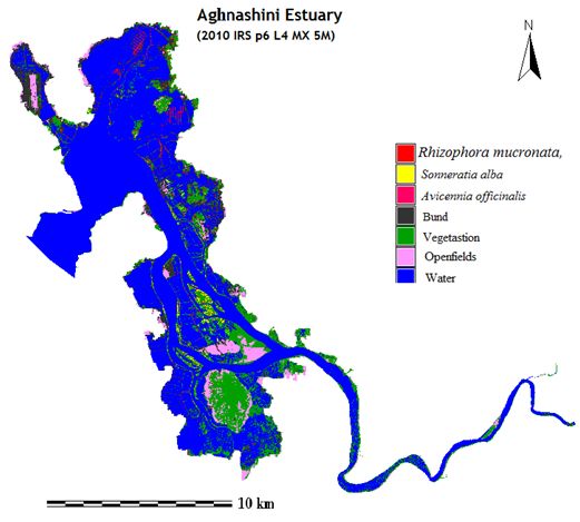
Figure. 3.2.12-15: Remote sensing imageries showing area under vegetation, water and open fields in the Aghanashini estuarine belt (including one km buffer zone)
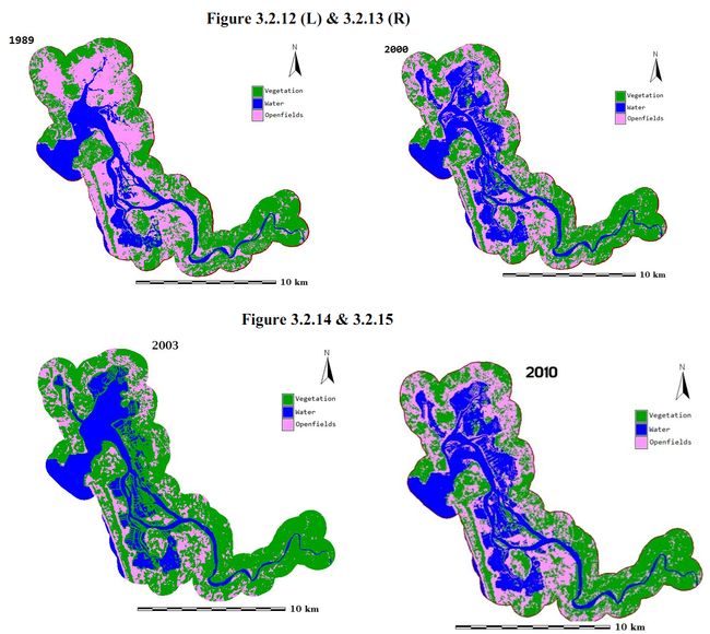
Details of area in ha under vegetation, water and open fields, including for 1 km buffer zone, are shown in Table 3.2.18. Part of the increase in area under vegetation in 2010 is due to increase in mangroves.
Table 3.2.18. Remote sensing data analysis for 1989, 2000, 2003 and 2010 for major landscape/waterscape elements for Aghanashini estuary, including 1 km buffer zone
| Year |
Vegetation |
Water |
Open fields |
| HA |
% |
HA |
% |
HA |
% |
| 1989 |
5675.238 |
40.79 |
2643.525 |
19 |
5595.85 |
40.22 |
| 2000 |
5483.632 |
39.41 |
2622.254 |
18.85 |
5808.728 |
41.75 |
| 2003 |
5435.506 |
39.06 |
3988.784 |
28.67 |
4490.323 |
32.27 |
| 2010 |
6250.39 |
44.92 |
3148 |
22.62 |
4516.21 |
32.46 |
| Total area |
13914.614 |
C. MANGROVES OF SHARAVATHI -BADGANI ESTUARINE COMPLEX
The Sharavathi or Gersoppa River has its origin at Ambutirtha in Thirthalli taluk of Shimoga District. After a northerly course of about 64 km from Nagar, it forms the south-east boundary of Uttara Kannada for about 13 km and then passes about 32 km west covering a total distance of 128 km in all to join the sea at Honavar. Soon after touching the border of Uttara Kannada district, the river water hurtles down vertically from a precipice of 252 m in to a pool 117 meters deep forming the famous Jog falls. About 30 km west, it reaches the ancient capital of Gersoppa. During the remaining 27 km to the coast, the river flows between richly wooded banks fringed with mangrove bushes. It was a broad tidal estuary with brackish water in the dry weather. But the execution of Linganmakki and Gersoppa dams for power generation found salinity conditions approaching almost fresh water conditions throughout the year, causing most high and medium salinity tolerant mangrove species vanishing from the estuary, leaving behind only those which can live in low brackish conditions.
About eight km from mouth, the river widens to a lagoon about three km broad, containing a few islands, the longest being Mavinkurve which is more than five km long with a large area of paddy lands and studded with mango and coconut. For about 2 km from the mouth, the river has a breadth of about 1.5 km. At the mouth, again it narrows into a channel about 275 meters broad. Outside of it lies a formidable and changing sand bar. The village Pavinakurve at its mouth near Honavar has been nearly washed off recently and the river has been depositing sand at Kasarkod on the left bank of its mouth.Sharavathi has an estuarine spread of approximately 27 kms.
Details regarding mangrove area and and area suitable for planting and their village-wise distribution are given in Table 3.2.19. Total area under mangroves in the Sharavathi part of estuary was estimated was 54.01 ha. Total potential area for mangrove planting was 124.7 ha. The Badgani estuary that merges with Sharavathi towards its opening in the Arabian Sea, salinity is higher, but being a small creek like area the mangroves are in small fragments (16.4 ha) and the potential area is also lesser (55 ha). Sharavathi-Badgani estuarine complex has a total waterspread area of 2695.8 ha.
Table 3.2.19: Village-wise mangrove area and area suitable for planting in Sharavathi-Badgani estuarine complex
| Sn |
Village |
Taluk |
Mangrove area (ha) |
Potential area for planting (ha) |
| 1 |
Berolli |
Honavar |
3.15 |
|
| 2 |
Hadinbal |
Honavar |
0.37 |
|
| 3 |
Haldipur |
Honavar |
10.27 |
22.22 |
| 4 |
Honnavar |
Honavar |
8.43 |
2.67 |
| 5 |
Hosad |
Honavar |
2.02 |
|
| 6 |
Hospattan |
Honavar |
21.57 |
6.98 |
| 7 |
Jalwal-karki |
Honavar |
|
1.59 |
| 8 |
Kadtoka |
Honavar |
0.57 |
|
| 9 |
Kakurve |
Honavar |
0.43 |
4.66 |
| 10 |
Kankichitta |
Honavar |
0.64 |
|
| 11 |
Karki |
Honavar |
8.44 |
14.54 |
| 12 |
Kasarkod |
Honavar |
20.74 |
67.59 |
| 13 |
Kelginoor |
Honavar |
0.77 |
|
| 14 |
Kharwa |
Honavar |
0.20 |
|
| 15 |
Kulkod |
Honavar |
1.96 |
|
| 16 |
Mavinkurve |
Honavar |
32.02 |
39.83 |
| 17 |
Melin-idgunji |
Honavar |
|
1.30 |
| 18 |
Molkod |
Honavar |
1.09 |
5.65 |
| 19 |
Mugwa |
Honavar |
2.55 |
|
| 20 |
Navilgone |
Honavar |
1.83 |
12.79 |
| 21 |
Padukuli |
Honavar |
0.13 |
0.29 |
| 22 |
Pavinkurve |
Honavar |
0.84 |
0.62 |
| 23 |
Harnir |
Kumta |
0.29 |
0.05 |
| 24 |
Holegadde |
Kumta |
2.32 |
15.41 |
| 25 |
Horbhag |
Kumta |
0.23 |
4.89 |
| 26 |
Konalli |
Kumta |
1.14 |
|
| 27 |
Madgeri |
Kumta |
9.35 |
0.79 |
| 28 |
Talgod |
Kumta |
0.26 |
1.35 |
| 29 |
Urkeri |
Kumta |
3.19 |
8.17 |
Salinity decline in Sharavathi
Most of Sharavathi estuary has uniformly low salinity, dipping down to 0.5 ppt or less many times, making conditions difficult for high and medium salinity requiring mangroves. Low salinity mangrove tree Soinneratia caseolaris flourishes in the estuary. Lowered salinity due to hydel projects has caused extinction of most high salinity tolerant species from Sharavathi part of estuary. Details of mangroves recommended for planting in the different salinity zones are given in Table 3.2.20. Mangrove associates recommended for planting are in Table 3.2.21.
Table 3.2.20:Mangrovesrecommended for planting in potential areas
| Sl.No. |
Mangroves sp. |
Medium salinity zone* |
Low salinity zone |
| 2 |
A. officinalis |
√ |
|
| 3 |
Excoecaria agallocha |
√ |
|
| 4 |
Kandelia candel |
√ |
√ |
| 5 |
Sonneratia alba |
√ |
√ |
| 6 |
R. mucronata |
√ |
|
| 7 |
S. caseolaris |
|
√ |
*5-10 ppt
Table 3.2.21: Mangrove associates recommended for planting in suitable areas
1 |
Barringtonia racemosa (In low salinity creeks only) |
2 |
Calophyllum inophyllum |
3 |
Cerbera manghas |
4 |
Dolichandron spathacea |
5 |
Erythrina indica |
6 |
Ficus racemosa |
7 |
Pandanus fascicularis |
8 |
Pongamia pinnata |
9 |
Ficus racemosa (Low salinity zone) |
Details of mangroves and associates: site-wise
Some localities in Sharavathi estuary were studied for mangroves in details (Table 3.2.22). Most widespread mangrove tree is the low salinity tolerant Sonneratia caseolaris, followed to a lesser extent by Kandelia candel. May be due to lowered salinity in the estuary the mangrove associates were prolifically growing in many localities. In Table 3.2.23 a list is furnished.
Table 3.2.22:Location-wise distribution of mangroves in Sharavathi estuary
| Sn |
Name |
Island
-1 |
Kasar-
kod |
Kalsana-
motte |
Hosa-patan |
Mulkod |
Mavin-kurve |
Kulkod creek |
| 1 |
Acanthus ilicifolius |
P |
|
|
P |
|
|
P |
| 2 |
Acrostichum aureum |
|
|
P |
P |
P |
|
|
| 3 |
Avicennia officinalis |
P |
|
|
|
|
|
P |
| 4 |
Excoecari agallocha |
|
|
|
|
P |
|
P |
| 5 |
Kandelia candel |
P |
P |
P |
P |
|
|
|
| 6 |
R. mucronata |
P |
P* |
|
|
|
|
|
| 7 |
Sonneratia alba |
P |
|
|
|
|
|
|
| 8 |
S. caseolaris |
N |
P |
P |
P |
P |
P |
P |
P: Present; P* Planted saplings
Table 3.2.23: Location-wise distribution of mangrove associates in Sharavati estuary
| Sn |
Name |
Kalsana- motte |
Hosa-patan |
MulkodIsland |
Devan-motte island |
Kulkodcreek |
| 1 |
Barringtonia racemosa |
|
|
√ |
|
√ |
| 2 |
Caesalpinia crista |
√ |
|
√ |
√ |
√ |
| 3 |
Calophyllum inophyllum |
√ |
|
|
√ |
|
| |
C. malaccensis |
√ |
√ |
√ |
√ |
√ |
| 4 |
Cerbera manghas |
√ |
√ |
√ |
√ |
√ |
| 5 |
C. inerme |
√ |
|
|
|
|
| 6 |
Derris canarensis |
|
|
√ |
|
|
| 7 |
Derris scandens |
|
|
√ |
√ |
|
| 8 |
Derris trifoliata |
|
|
|
|
√ |
| 9 |
Dolichandron spathacea |
|
|
√ |
|
√ |
| 10 |
Erythrina indica |
|
|
|
|
√ |
| 11 |
Ipomoea fistulosa |
|
|
√ |
|
|
| 12 |
Pandanus fascicularis |
√ |
√ |
√ |
√ |
|
| 13 |
Pongamia pinnata |
|
|
√ |
|
√ |
| 14 |
Premna corymbosa |
√ |
|
|
√ |
√ |
| 15 |
Sapium insigne |
|
|
|
|
|
| 16 |
Thespesia populnea |
√ |
|
|
|
|
| 17 |
Vitex negundo |
|
|
|
√ |
|
Locality-wise details: Sharavathi
Island-1: This small uninhabited island situated midway between the bridges of national highway and the railway is due to accretion of materials, and is hardly above water level. The island is fully covered with low mangroves and has abundance of the sedge Cyperus malaccensis. Small trees or saplings of Rhizophora mucronata, Kandelia candel, Sonneretia alba are found here. Acanthus ilicifolius grows plentifully.
Kasarkod: Adjoining the tile factory of Kasarkod is a good patch of mangroves. This includes a planted patch of R. mucronata, where most individuals are 2 to 2.5 m in height. Another is almost a pure patch of Sonneretia caseolaris, which stands well the influx of fresh water throughout. The trees have heights ranging from 4-7 m. Our sample survey shows the Kasarkod patch of mangroves has stem density of 2188/ha and basal area of 13.43 sq.m.
Kalsanamotte: This is a small island, one side of which is inhabited. S. caseolaris thrives well here fringing the borders of the island. The mangrove fern Acrostichum aureum, Cyperus malaccensis and Kandelia candel are also found here. Notable of the mangrove associates are Calophyllum inophyllum, Caesalpinia crista, Clerodendron inerme, Cerbera manghas and Pandanus fascicularis. This place is somewhat unique in the Honavar Forest Division in having some trees of Thespesia populnea, rarely found elsewhere.
Hosapatan: The river bank is fringed with isolated individuals of S. caseolaris and K. candel. A. ilicifolius and C. malaccensis are found all over the edges. Of the mangrove associates are C. manghas and P. fascicularis.
Mulkod island: The river is almost fresh water here and very few mangroves are still seen here. These are S. caseolaris, E. agallocha and A. ilicifolius. Excoecaria agallocha are all older individuals without any regeneration. A. aureum is also found in moderate numbers. The island is rich in mangrove associates like C. manghas, Derris spp. and P. fascicularis. Rarely found are Barringtonia racemosa, Dolichondron spathacea, Calophyllum inophyllum and C. crista.
Devanmotte island: Fringing the island all along are S. caseolaris. Cyperus malaccensis is also common. Mangrove associates are many such as C. inophyllum,C. crista, C. manghas, C. inerme, P. fascicularis and Vitex negundo.
Mavinkurve island: The island is surrounded by S. caseolaris, which attain fairly big heights ranging from 13 to 16 m; these are presently candidates for tallest mangroves of the Honavar Division. The local residents informed us that many of these trees are planted by them in their own lands, about 20 years ago. Extrapolating tree density for one ha the stem count could be 1600/ha, and the estimated basal area 60.21 sq. m/ha. Though this is not the real situation, the estimate clearly shows that Sharavati river fringes (including tidal edges of islands) are highly suitable for raising plantations of, particularly S. caseolaris. The basal area estimate of 60.21 sq.m/ha is as good as the best forest patch in Uttara Kannada district. The farmers can at least partly meet their biomass needs through mangroves, while they also enhance productivity and biodiversity of ecosystem as well as afford protection from natural calamities.
Kulkod creek: On the sides of this creek are many mature trees of A. officinalis. Sonneratia caseolaris is also frequent. E. agallocha is occasionally found. There is plentiful growth of A. aureum and A. ilicifolius and C. malaccensis. Of the mangrove associates may be mentioned B. racemosa, C. manghas, D. trifoliate, D. spathacea, Erythrina indica, Pandanus fascicularis, P. pinnata, Premna corymbosa etc.
Factors affecting mangrove community
The stone embankments on both sides of the river in most places do not favour the growth of mangroves. The islands are better places for some of the mangroves, and with some amount of awareness creation these islands can be shielded with mangroves, notably by S. caseolaris. Constant release of fresh water from hydel projects in the river and the formidable sandbar blocking most of the river mouth have made Sharavathi estuary almost into a fresh water lake. Few are the mangroves which can survive in this situation. In many places the residents along the river banks have extended their gardens right into the river by building compound walls.
Badgani estuary
Table 3.2.24: Location-wise distribution of mangroves in Badgani creek
| Sl no |
Name |
Pavinkurve |
Taarebagilu |
Badgani bridge |
| 1 |
Avicennia officinalis |
P |
P |
|
| 2 |
Rhizophora mucronata** |
P |
|
P |
| 3 |
Kandelia candel |
P |
P |
P |
| 4 |
Sonneratia caseolaris♠ |
P |
|
|
| 5 |
Acanthus ilicifolius |
P |
P |
P |
| 6 |
Aegiceras corniculatum |
P |
|
P |
| 7 |
Excoecaria agallocha |
P |
|
P |
♠Only single tree noted; ** Seedlings noted; P : present
Pavinkurve: This village, is situated close to the mouth of Badgani. The seashore of Pavinkurve is very vulnerable to sea erosion during the rainy season. The estuarine mouth is bunded with granite rocks and has hardly any scope for growth of mangroves. However, the estuarine part has very good potential for mangrove regeneration. Most of the low-lying areas, alongside the estuary, formerly fields of rice, are today shrimp farms. Mangroves appear to have suffered badly due to human impact, in the recent years. Big trees are very scanty. The creek has saplings of R. mucronata, A. officinalis, A. corniculata and E. agallocha. Pavinkurve is notable for large number of mangrove shrub A. corniculatum. The shrubby A. ilicifolius forms in many places impenetrable patches. Of late prawn farming is declining due to rainy season flooding and increased incidence of prawn diseases.
Tarebagilu: Acanthus ilicifolius is the most dominating formation of mangroves. Trees are scanty due to human disturbances. The areas adjoining have been converted into shrimp farms. Some trees of A. officinalis could be seen in the area.
Badgani bridge: Close to this bridge on the national high way, the Forest Department has recently planted several seedlings of R. mucronata. The habitat is not all that good at this region for mangroves, due to various human disturbances. These include fishermen casting nets and grazing and trampling by livestock, particularly by buffaloes. Most lands, otherwise suitable for mangroves, has been converted into aquaculture ponds or shell-mining areas. Some small bits of mangroves left, being sacred spots to the locals, few mangrove trees are left. These are E. agallocha, K. candel and A. corniculatum. A. ilicifolius is common within the estuary as well as in water-logged abandoned rice fields alongside.
Remote sensing for mangrove species/land cover-land-use prospecting
Using remote sensing imagery from 2410 IRS p6L4 MX5 M it was possible to make an assessment of area under tree mangrove species and other waterscape/landscape elements in the Sharavathi-Badgani estuarine complex proper as shown in the Table 3.2.25
Table 3.2.25: Area estimates under tree mangroves and other waterscape/landscape elements in Sharavathi-Badgani estuarine complex properusing 2410 IRS p6L4 MX5 M imagery
| Category |
Ha |
% |
| Avicennia officinalis |
10.70 |
0.31 |
| Sonneratia alba |
23.00 |
0.67 |
| Kandelia candel |
6.81 |
0.20 |
| Rhizophora mucronata |
5.41 |
0.16 |
| Sonneratia caseolaris |
81.96 |
2.40 |
| Plantations |
219.65 |
6.44 |
| Vegetation |
515.21 |
15.08 |
| Water |
1334.90 |
39.08 |
| Open space |
1218.12 |
35.66 |
| Total area |
3415.75 |
Figure 3.2.16. 2010 IRS p6 L4 MX 5M imagery of Sharavathi-Badgani estuarine complex proper showing distribution of tree mangroves (4 species), waterscape area, plantations, fields etc.
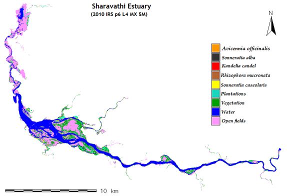
Figures 3.2.17-20. RS images of 1989, 2000, 2003 and 2010 of Sharavathi-Badgani estuarine complex including of 1 km buffer zone
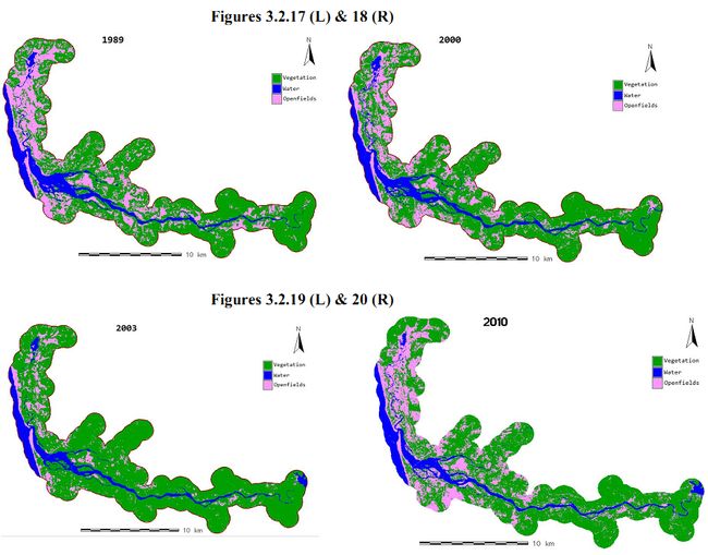
Landuse landcover changes as evident from RS imageries
Details of changes in landuse/landcover, waterscape area in the Sharavathi-Badgani estuarine complex, including 1 km wide buffer zone, using remote sensing data, for the years 1989, 2000, 2003 and 2010 are given in Table 3.2.26
Table 3.2.26: Transitions in landuse-landcover during 1989-2010 period as seen from RS imageries (includes also 1 km buffer zone)
| CategoryYear |
Vegetation |
Water |
Open fields |
| Ha |
% |
Ha |
% |
Ha |
% |
| 1989 |
11111.373 |
59.7 |
2237.259 |
12.02 |
5263.123 |
28.28 |
| 2000 |
11049.269 |
59.37 |
2264.911 |
12.17 |
5297.575 |
28.46 |
| 2003 |
11076.469 |
59.51 |
2046.437 |
11 |
5488.849 |
29.49 |
| 2010 |
11258.783 |
60.49 |
2497.855 |
13.42 |
4855.117 |
26.09 |
| Total area |
18611.75 |
D. MANGROVES OF VENKTAPUR RIVER
The Venktapur River rises in the Western Ghats near the village Kanti towards the north-east corner of Bhatkal. It joins the Arabian Sea at Venktapur towards the north of Bhatkal town. The river, for the last 5 km forms a tidal estuary where occur the mangroves (Figure 3.2.21). The first organized efforts to study the mangroves of Venktapur were made by Ananda Rao and Suresh (2001). Notably we could not collect Avicennia alba, which was rather widespread according to Rao and Suresh (2001). Whereas Sonneretia alba has widespread distribution in our study the same was not reported by Rao and Suresh (2001). The true mangroves recorded by these authors village-wise are given in Table 3.2.27.Table 3.2.28 contains details of true mangroves recorded by Rao and Suresh (2001) and in the present study. We could not locate Avicennia alba which was reported by earlier authors. Venktapur estuary is the only place in Honavar Forest Division having rare presence of Bruguiera gymnorrhiza. Details of location-wise mangroves and associates are given in Table 3.2.29.
Figure 3.2.21. Venkatapur estuary showing mangrove areas and potential areas
| Table 3.2.27: Village-wise details of mangrove area and potential area available for planting in Venktatpur estuary |
| Sn |
Village |
Taluk |
Mangrove area in ha. |
Potential area available for planting (ha) |
| 1 |
Bengre |
Bhatkal |
1.478 |
1.433 |
| 2 |
Heble |
Bhatkal |
2.801 |
7.187 |
| 3 |
Kaikini |
Bhatkal |
2.497 |
|
| 4 |
Shirali |
Bhatkal |
10.495 |
16.300 |
| 5 |
Venktapur |
Bhatkal |
3.308 |
1.911 |
Table 3.2.28: Mangroves of Venktapur reported by Rao and Suresh (2001) and in the present study
| Sn |
Name of mangrove |
Rao & Suresh (2002) |
Present study |
| 1 |
Avicennia alba |
P |
Unconfirmed |
| 2 |
A. officinalis |
P |
P |
| 3 |
A. marina |
N |
P |
| 4 |
Aegiceras corniculatum |
P |
N |
| 5 |
Excoecaria agallocha |
P |
P |
| 6 |
Sonneratia alba |
N |
P |
| 7 |
S. caseolaris |
P |
P (rare) |
| 8 |
R. mucronata |
P |
P |
| 9 |
Kandelia candel |
P |
P |
| 10 |
Bruguiera gymnorrhiza |
P |
P (rare) |
| 11 |
Acanthus ilicifolius |
P |
P |
| 12 |
Acrostichum aureum |
P |
P |
| 13 |
Cyperus sp. |
P |
P |
Note: P : present; N : Not found.
Table 3.2.29: Location-wise distribution of mangroves & mangrove associate species
| Sn |
Mangroves |
Heble |
Mogerkeri |
Alvekodi |
Kurigadde |
Hegle |
Mullanakeri |
Kandatahitl |
| |
Mangroves |
|
|
|
|
|
|
|
| |
Acanthus ilicifolius |
|
+ |
+ |
+ |
+ |
+ |
+ |
| |
Acrostichum aureum |
|
|
|
|
+ |
|
|
| |
Aegiceras corniculatum |
|
|
|
|
|
|
|
| |
Avicennia marina |
+ |
|
+ |
|
|
+ |
|
| |
Avicennia officinalis |
+ |
+ |
+ |
+ |
+ |
|
+ |
| |
Brugiera gymnorrhiza |
+ |
|
+ |
+ |
+ |
+ |
|
| |
Cerbera odollum |
|
|
+ |
|
|
|
|
| |
Excoecaria agallocha |
+ |
+ |
+ |
+ |
+ |
|
+ |
| |
Kandelia kandel |
|
|
+ |
|
+ |
+ |
+ |
| |
Porteresia coractata |
|
|
|
|
|
|
|
| |
Rhizophora mucronata |
+ |
+ |
+ |
|
+ |
+ |
+ |
| |
Sonneratia caseolaris |
|
|
|
|
+ |
|
|
| |
Sonneretia alba |
+ |
|
+ |
+ |
|
|
|
| |
Mangrove associates |
|
|
|
|
|
|
|
| |
Caesalpinia crista |
|
+ |
|
|
|
|
|
| |
Caeslpinia nuga |
|
|
|
|
+ |
|
|
| |
Calophyllum inophyllum |
|
|
+ |
|
|
|
|
| |
Clerodendron inerme |
+ |
+ |
+ |
|
+ |
|
|
| |
Cuscuta spp. |
|
|
|
|
+ |
|
|
| |
Derris trifoliate |
|
+ |
+ |
|
+ |
|
|
| |
Erythrina indica |
|
+ |
+ |
|
|
|
|
| |
Pandanus sp. |
|
|
+ |
|
|
|
|
| |
Premna corymbosa |
|
+ |
+ |
|
+ |
|
|
Heble: Heble has small promising patches of mangroves. The soft, muddy soil is favourable for mangrove growth. According to local informants the mangroves suffered major setback due to clearance for prawn farming. Sometimes they are cut for fuel and poles. Subsequently they were allowed to grow and what present now are mostly coppice shoots. The owners of the land presently believe that the mangroves can give protection from strong winds. The tree community sampled is composed of 70% S. alba, 28% of A. offficinalis and 2% R. mucronata. Some saplings of the rare mangrove Bruguiera gymnorrhiza are also found.There are some coppicing individuals of A. marina. E. agallocha occurred along the edges. A. ilicifolius is common.
Mogerkeri: Fringing the creek are isolated trees and bushes of mangroves such as: R. mucronata, A. officinalis, A. ilicifolius and E. agallocha, There are also R. mucronata planted along the bank, in the recent years by the Forest Department. The survival of the planted mangroves is not satisfactory. The mangrove associates are C. inerme, D. trifoliata, Caesalpinia nuga, Premna serratifolia, Erythrina indica etc.
Alvekodi: This place has linear formation of mangroves along the fringes. The species found are Avicennia marina, A. officinalis, Excoecaria agallocha and Acanthus ilicifolius. Rarely found are Sonneretia alba. Avicennia marina consists of mostly coppicing plants. The mangroves are under high degree of human impacts. Near the bridge the Forest Department has planted Rhizophora mucronata. Notable of the mangrove associates are Erythrina indica, Premna corymbosa, Clerodendrum inerme and Derris trifoliata etc. More upstream in the creek are Cerbera odollum, Pandanus fascicularis and C. inophyllum.
Kurigadde: This is a small island in the river. The island was reportedly under paddy cultivation once, but now it is in abandoned state. The island is colonized by A. ilicifolius,A. officinalis, S. alba and E. agallocha. Sedge grass (Fam: Cyperaceae) is found along the edges. E. indica, C. inerme are notable mangrove associates.
Hegle: A opportunistic survey carried out for a distance of 2 km from Venktapur river bridge to Hegle. In this belt of estuary are found A. ilicifolius, A. officinalis, E. agallocha, K. candel, Rhizophora mucronata, and the fern A. aureum. Near the hamlet of Hegle, occurs one tree each of Sonneretia caseolaris and Bruguiera gymnorrhiza, the latter is the rarest species in the Honavar Forest Division. Occasionally found are planted saplings of R. mucronata. Along the edges of the creek are mangrove associates C. crista, D. trifoliata, P. corymbosa and C. inerme. Doddar, a yellow coloured, wiry, leafless parasitic creeper is found on some of the bushes.
Mullanakeri: Here about 300m² is covered with dense growth of A. ilicifolius and coppicing bushes of A. marina. This is a potential patch for mangrove restoration. Another 200m² is also covered with A. ilicifolius and saplings of K. candel. Bruguiera gymnorrhiza and A. officinalis were also are present. Nearby was noted 17 saplings of R. mucronata planted by the Department. Perhaps many saplings of the species did not survive here. Another 600m² presently covered with A. ilicifolius is a potential area for mangrove restoration. Kantadahitlu in the creek has also some mangroves. Dense patches of the spinous undershrub A. ilicifolius has covered many parts of the creek. Within these patches of Kantadahitlu natural regeneration of A. officinalis and K. candel can be observed.
Applications of remote sensing for mangrove mapping for 1989-2010 period
Using RS data of 1989-2010 period overall vegetation cover increase was noticed; it is difficult to tell whether there was any increase in mangroves (Table 3.2.30-31; Figures 3.2.22)
Table 3.2.30.Venkatapur estuary proper: area under individual tree mangroves (for 3 species only) and other landscape/waterscape elements as deciphered from 2010 IRS p6L4 MX5 M imagery
| Category |
HA |
% |
| Avicennia officinalis |
9.928 |
4.53 |
| Sonneratia caseolaris |
0.711 |
0.32 |
| Sonneretia alba |
5.636 |
2.57 |
| Vegitation |
56.545 |
25.81 |
| Open fields |
70.933 |
32.38 |
| Water |
75.336 |
34.39 |
| Total area |
219.089 |
Figure 3.2.22: Venkatapur estuary proper, including islands, showing tree mangroves, bunds, other vegetation, fields and waterspread area
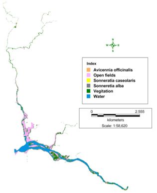
Table 3.2.31: Changes in details on area under vegetation, water and fields based on RS imageries (1989-2010)-includes 1 km buffer zone also-
| |
Vegetation |
Water |
Fields |
| Ha |
% |
Ha |
% |
Ha |
% |
| 1989 |
226.17 |
28.2 |
87.84 |
10.95 |
488.07 |
60.85 |
| 2000 |
243.54 |
30.36 |
84.87 |
10.58 |
473.67 |
59.06 |
| 2003 |
269.36 |
33.58 |
55.98 |
6.98 |
476.74 |
59.44 |
| 2010 |
272.33 |
33.95 |
125.36 |
15.63 |
404.39 |
50.42 |
| Total area |
802.08 |
Figures 3.2.23-26: RS images of 1989, 2000, 2003 and 2010 of Venkatapur estuary including of 1 km buffer zone
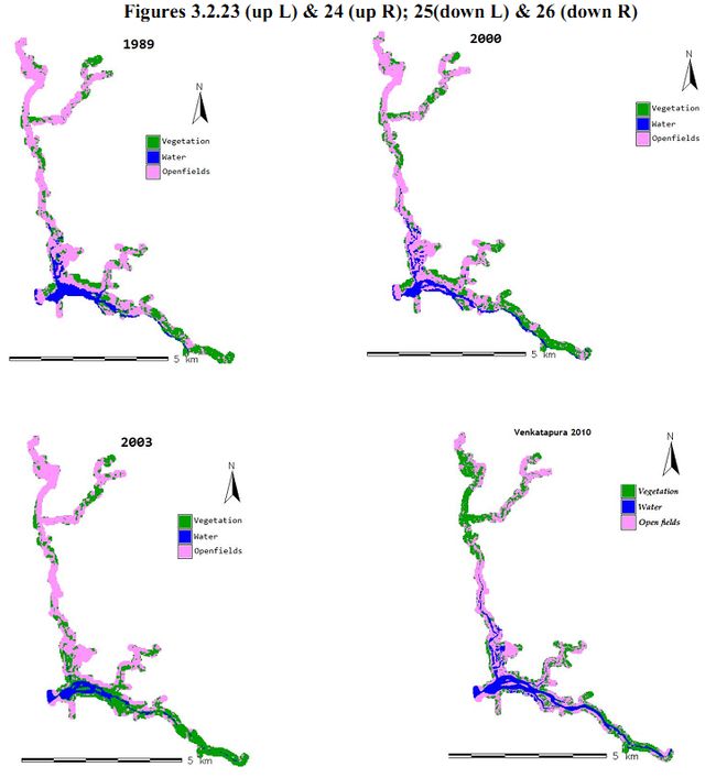
E. ALVEKODI CREEK
This is the only notable creek in the division with mangroves. The others are smaller ones and dealt with as part of the estuaries with which they are linked. Alvekodi creek is towards the mouth of a small stream in Kumta. The old town of Kumta is situated on its north bank. The creek had in the past seen considerable trade especially in cotton, spices and various other products. Ever-since Bomaby-Hubli rail link was made the trade vanished. Today it only serves the transport of fish by small boats from the sea to the Kumta fish market. Details regarding mangrove areas and potential areas are given in Table 3.2.32-33 and Figure 3.2.27
Table 3.2.32:Kumta creek proper: area under mangroves and potential area
| Category |
Area in ha |
| Potential |
42.4 |
| Mangrove |
14.2 |
| Total water spread |
238.1 |
Figure 3.2.27: Kumta creek proper, mangroves, Potential area and waterspread area
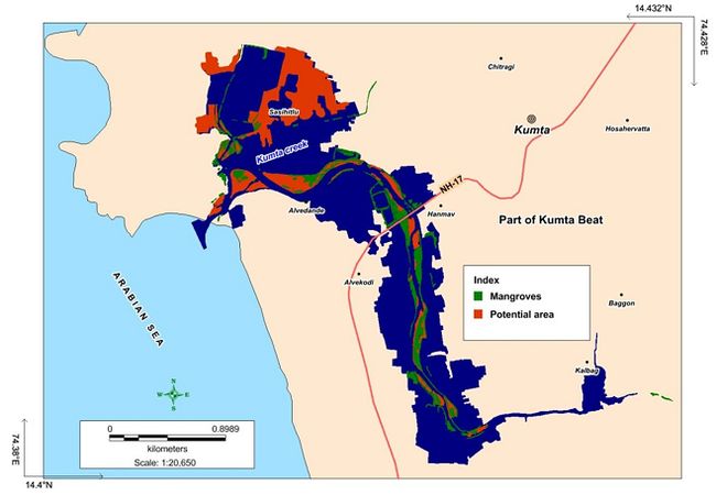
Table 3.2.33: Village-wise mangrove area and area suitable for planting in Kumta creek
| Sn |
Village |
Taluk |
Mangrove area (ha) |
Potential area for planting (ha) |
| 1 |
Kalbhag |
Kumta |
6.32 |
3.71 |
| 2 |
Kumta Town |
Kumta |
7.71 |
36.09 |
| |
|
Total |
14.03 |
39.80 |
Status of mangroves
At one time the creek with shallow water and mud-flats must have been full of mangroves. In due course the low lands alongside have been reclaimed for cultivation, salt making and human settlement. In the recent times the wetlands alongside have been embanked for prawn farming. The details of mangroves in the estuary are given below. In the recent years good efforts at mangrove afforestation have been made by the Forest Department. Mangroves have been studied at Honmav, near fish market, Sasihitlu and Devgundi.
Honmav: Good growth of natural mangroves of low height occurs between NH bridge and the fish market bridge. The estuary bed is full of boulders covered with oyster shells. Dense patches of dwarf mangroves of species such as A. officinalis, A. marina, R. mucronata and S. alba are found here. There are also K. candel, E. agallocha and A. ilicifolius. Towards the upstream, eastwards of the NH bridge are found plantations dominated by R. mucronata in excellent growth. Of the mangrove associates are Clerodendron inerme, Derris trifoliata, Caesalpinia bonducella etc.
Devagundi: Further upstream along the creek the mangroves almost come to an end here. Only species found here are A. officinalis and E. agallocha. Most of these are coppices and are subjected to much hacking. Prawn farms without any traces of plant growth exist all along the sides of the creek.
Near fish market: Near the fish market of Kumta the creek is dominated by A. officinalis, A. marina and A. ilicifolius.
Sasihitlu: This part of the creek, almost up to its mouth is an area subjected to much anthropogenic pressures. The mangroves found here are A. officinalis, A. marina, R. mucronata, K. candel, S. alba and E. agallocha. Stream bank has narrow stretch of land suitable for mangrove afforestation. Common mangrove associates are C. inerme, D. trifoliata and E.variegata.
