Energy and Wetlands Research Group, Centre for Ecological Sciences, Indian Institute of Science, Bangalore – 560012, India.
*Corresponding author: cestvr@ces.iisc.ac.in
INTRODUCTION Mangroves are a group of plants that occur in the coastal intertidal zones of tropics and the sub-tropics. The mangrove community as a whole consists of salt tolerant plants of soft and swampy mud, mostly trees and shrubs, with broad, leathery, evergreen leaves.In some trees roots from the main stem and branches grow vertically down and provide additional support like stilts in an unstable, slipperysubstratum.In many others roots protrude into the air like sticks, knobs or loops, or creep in serpentine manner all around the tree, exposed fully during the low tide. These roots are meant for taking in air for respiration, as the water-logged soil is deficient in oxygen. In some trees the seeds germinate while the fruits are still attached to the plant, and green seedlings of varied lengths hang from the parent plants until they achieve appropriate length, specific to the species, drop vertically down into the soft mud. Soon they develop the root system and become independent plants. This nature of certain mangroves to ‘give birth’ to live seedlings instead of shedding their fruits or seeds is known as vivipary (Woodroffe, 1987;Blasco et al., 1996;Duke et al., 1998). The term mangroves refer to an ecological group of halophytic plant species which is known as the salt tolerant forest ecosystem and provides a wide range of ecological and economic products and services, and also supports a variety of other coastal and marine ecosystems. Mangroves occupy less than 1% of the world’s surface (Saenger et.al, 1983) and are mainly found between the Tropic of Cancer and the Tropic of Capricorn on all continents covering an estimated 75 percent of the tropical coastline worldwide. Mangroves make special type of vegetation that exists at the boundary of two environments using a variety of survival and reproductive strategies.Till about 1960s, mangroves were largely viewed as “economically unproductive areas” and were therefore destroyed for reclaiming land for various economic activities. Gradually, however, the economic and ecological advantages of mangroves have become visible and their importance is appreciated. Every ecosystem supports human life by giving direct or indirect benefits and services. Mangrove areas today rated among the most productive ecosystems on this planet(Odum 1971). Mangroves constitute one of the important parts of an estuarine ecosystem and in fact form an icon for the estuarine ecosystem. A layer of earth or sand, usually deposited by rivers and flood tides and shore free of strong wave and tidal action promotes extensive development of mangroves. They also require salt and brackish water. Mangroves are best developed on tropical shorelines where there are large areas available between high and low tide points. Large mangrove formations are typically found in sheltered muddy shorelines that are often associated with the formation of deltas at the mouth of a riverine system. Mangroves can also be found growing on sandy and rocky shores, coral reefs and oceanic islands. There are instances where islands can be completely covered by mangroves. It is impossible to describe a typical mangrove, as the variation in height and girth, even for the same species, is immense, depending on the many factors that control growth. Importance of Mangroves: Mangroves forests, in their well developed state, constitute one of the most productive features of coastal ecosystems across tropical and subtropical regions of the world. By generating nutritionally important detritus, used by fishes, prawns, crabs, oysters etc. for reproduction and growth and by sheltering of various kinds of animals such as fish, crustaceans, birds, reptiles, and mammals mangroves play an important role in the ecosystem functioning and are considered of great economic importance for capture and captive fisheries. Detritus is also transported, distributed and consumed as food by various detritivorous estuarine and near-shore organisms. A rich biodiversity is observed in the mangroves with plants and animals, which are irreplicable, and forms a good genetic treasure house. Mangrove wetlands are a multiple use ecosystem that provides protective, productive and economic benefits to coastal communities. Mangroves contribute to the stabilization of the shoreline and prevention of shore erosion. They serve as a barrier against storms so as to lessen damage to coastal land and residents. The dense network of supporting roots and breathing roots give mechanical support to the tree and trap the sediments. Without mangroves, all silt will be carried into the sea, where turbid water might cause corals to die. Mangrove trees act as sinks, which concentrate pollutants such as sewage, toxic minerals, pesticide, herbicides, etc. (FAO, 1982; Saengeret al., 1983; Hamilton and Snedaker, 1984; Alongi, 2002). The mangrove ecosystems are associated with rich diversity of organisms and are also the nursery and breeding ground of several marine fauna like prawns, crabs, fishes and molluscs. They enhance the fishery production of nearby coastal waters by storing nutrients and detritus. Through shedding of their leaves mangroves tend to remove salt accumulated in them. However, most land plants, except the halophytes, are incapable of such tolerance to salty environments. The shed leaves of mangrovesturn into detritus, which is colonized by fungi and bacteria and this detritus turn into a valuable pool of nutrients. This detritus is consumed by variety of bivalves, shrimps and fishes, many of which migrate into the mangrove areas for better feeding and protection. Birds are a prominent part of most mangrove forests and they are often present in large numbers. Almost 120 birds are found in the Aghanashini estuary of Kumtataluk in the Honavar Forest Division. They use mangrove environs as breeding and feeding grounds. The Royal Bengal Tiger is one of the unique resident species of mangroves of the Sunderbans. Mangroves sustain the ecological security of the coastal areas as well as livelihood security of the thousands of fishing people of estuarine and coastal villages. Nevertheless, because mangroves grow where nothing else grows, they are always useful, even where they cannot be managed as productive forests. The enrichment of brackish and coastal waters provided by the mangrove vegetation may be substantial and should not be overlooked. Good mangrove vegetation is an excellent indicator of the health of coastal ecosystems. Mangrove ecosystem traps and cycles various organic materials, chemical elements and important nutrients. The roots provide attachment surfaces for many organisms. Many of these attached animals filter water through their bodies and, in turn, trap and cycle nutrients. Mangroves provide protected nursery areas for fishes, prawns, crabs and shellfish. They provide food for multitudes of marine and estuarine animals, such as various fishes and prawns of diverse species, oysters etc. Many animals find shelter amidst the network of roots, where fisherman cannot cast his nestnor the boatman ferry through it. Thegeneral importance of mangroves at many levels is provided in Table 1.1 Table-1.1: The general uses of mangroves and mangrove associates
Mangroves for food security: Many nurture the misconception that mangroves are dreaded and disease causing impenetrable swamps and they need to be cleared and reclaimed for the sake of public health. In fact the value of mangroves as storehouses of food, directly in the form of edible mangrove products and honey and indirectly in the form of enhanced fishery resources, ismore known to the inhabitants of estuarine villages. Today, there is rising global awareness on the importance of mangroves.Crabs, clams, oysters, fish and other food are often collected there. Mangrove trees grow well in their special conditions, and, like the tropical forest, produce a lot of leaves and other organic matter. The leaves fall in the water, where they disintegrate due to fungal and microbial action. This detritus becomes food for shrimps, crabs, oysters, shellfishes and so on, which are of immense importance in human subsistence and commerce. An entire detritus based food web of the coastal wetlands is mainly based on mangroves. This rich food is not only eaten in the mangrove swamp, but much of it may be carried out into the lagoon or to coral reefs and other coastal fisheries areas, where it helps to feed the fish. The areas near mangroves are thus often very important for fishing. A positive correlation between mangrove area and near-shore fish and shrimp catches was reported demonstrated in the Philippines, Malaysia, Indonesia and Australia. Mangrove swamps are critical nursery grounds and refugia from predation for commercially important shrimps of Penaeusspp. and spiny lobster (Panulirusargus). It has been estimated that 60% of the commercial catch in Fiji depends on mangroves (Hamilton &Snedaker, 1984). In theMatang mangrove swamp of Malaysia the contribution of mangrove carbon to prawn tissues was as high as 84% in the swamp. It decreased in the offshore direction, where the contribution of phytoplankton became more important (Chong et al., 2001). The study by Boominathan et al (2008)estimated that about 22,000 tons/year of edible bivalves, worth Rs.66 crore at current market prices, were collected from the Aghanashini estuary alone in the Honavar Forest Division. These bivalves are detritus feeders and obviously vegetation resides, including from mangroves, feed them and also many fishes, crabs, crustaceans etc. The shell deposits of these bivalves worth several millions of rupees are mined out annually from the same estuary. This is apart from the rich fisheries that the estuary support year after year. Mangroves are fish aggregating systems; they improve fish productivity. Fishes require a cool area to breed in and mangroves provide that (Balasubramanian, 2006). Because the mangrove swamps provide food security and the entanglement of roots shelter from fishing, many marine and estuarine fishes come to the swamps for egg laying and for the sake of nursery for their young ones before the parents depart to the oceans or into coral reefs and lagoons. The mangroves are a critical habitat upon which these species depend for survival, and if something happens to the mangroves, the future of these kinds of fish will be affected (Silas, 1986). The breakdown of significant quantities of mainly the leaf litter in the mangrove swamp releases significant amounts of nutrients and matter (Lu & Lin, 1990;Steinke et al., 1993) which supports tree productivity and the mangrove food web. Mangrove forests tend to be net exporters of organic matter. The nutritional value of detritus is increased by decomposing fungi and other microbes. The fine particles of detritus form a food source for young ones of bivalves, shrimps and fishes, which migrate into the mangrove environments for better feeding and protection. Mangroves are, in short, breeding, feeding and nursery grounds for many estuarine and marine organisms. More the mangroves better would be the catches of fishes, shrimps, and bivalves.
Mangroves for coastal protection: A number of studies have confirmed the function of mangroves in terms of a green belt (Janssen & Padilla, 1999; IUCN, 2005). Among the most commonly known and discussed roles of mangroves are those of providing coastal protection against storms, waves and water currents, thus reducing erosion and flooding. Dense root system of mangroves, deeply anchored in mud, help to reduce wave action, increase the sedimentation rate and enhance soil consolidation and stability which provide a good form of natural coastal protection (Siddiqi, 1993). The role of mangroves in protection of the life and property along the coast is being strongly realized today after the 1999 super cyclone of Orissa and the tsunami of 2004. In October 1999, a super cyclone, with wind speeds of 160 miles per hour struck Orissa and killed at least 10,000 people and rendered homeless 7.5 million. However, those human settlements located behind the mangrove swamps suffered little loss. The villages in and around Bhitarkanika were spared much of the cyclone’s fury because of the vast mangrove forest. Bhitarkanika is the second largest mangrove formation in India, next only to the Sunderbans (Venkataraman, 2004). Similar observations were made on December, 26, 2004 when the tsunami struck South-east Asia and parts of south Asia. Those human settlements located behind the mangrove swamps suffered little loss, according to observations from parts of Indonesia, Andaman and Nicobar, Sri Lanka and Kerala, Tamil Nadu and Andhra Pradesh. ThirunalThoppu, a fishing village of Tamil Nadu coast having 172 families was saved from the wrath of this tsunami by the dense growth of mangroves. In three other villages of Tamil Nadu coast also the tsunami damage was minimized by mangroves. According to V. Selvum of M.S. Swaminathan Foundation: “Even though the mechanical impact of a tsunami is enormous, and is bound to destroy the first line of mangroves, the water suddenly slows down as it moves farther in” (Kremmer, 2006).In parts of South India, with dense mangroves, fewer people suffered from this tsunami and less property was destroyed compared to the areas without mangroves (Kathiresan and Rajendran, 2005). That mangrove forests protect uplands from stormy winds, waves and floods had been well known in the past. The amount of protection afforded depends upon the width of the forest. Whereas very narrow fringe of mangroves offers only limited protection, a wider belt of mangroves, with their entanglement of aerial roots, can considerably reduce wave and flood damage to landward areas by absorbing the overflowing water. Mangroves can help prevent erosion by stabilizing shorelines with their specialized root systems. This fact has been known to the traditional gazni farmers of Aghanashini. Before the permanent stone bunds were built by the State Government, the farmers used to prepare earthen bunds and fortify them on the tidal side by planting of mangroves. Mangroves build land or keep it from being washed away, which can be very important on islands where land is so limited. Mud and sediment are often washed down by the rivers and streams. When there is a mangrove swamp at the river mouth, the water spreads out into the mangroves, and the sediment settles to the bottom where it is trapped by the mangrove roots. As the bottom gets shallower, the mangroves can grow further out, while those on the inside eventually find themselves on dry land, where they are replaced by land plants. In this way the mangrove forest advances slowly outward, leaving land behind. Even in areas where enough sediment is not available to build new land, the mangroves protect the shoreline from being washed away in storms. The roots and trunks break the force of the waves, and the leaves and branches reduce the effects of the wind and rain. There are examples of islands which were built by mangroves, and then washed away when the mangroves were cut. Maintenance of water quality: Mangroves filter water and maintain water quality and clarity. In many parts of the world, mangrove deforestation is causing not only fisheries declines but also causing degradation of clean water supplies. Fixation of carbon dioxide: Mangrove deforestation is causing release of more carbon dioxide into the atmosphere. In fact mangrove forests fix more carbon dioxide per unit area than phytoplankton in tropical oceans. M.S. Swaminathan (2005) states mangroves will serve as carbon sink, helping to enhance carbon sequestration and thereby contributing to reduce the growing imbalance between carbon emissions and absorption. Source of salt resistant genes: Mangroves form a rare and unique group among flowering plants because of their capacity to grow in flooded conditions and in their salt tolerance. According to M.S.R.Foundation, Chennai they are genetic pools for salt resistant genes. The Kagga rice variety of coastal UttaraKannada, is one well known instance of certain amount of salinity tolerance. The world is going to be in trouble soon because of the climate change. Sea level is going to rise and seep into farming areas. The time comes soon we will need salt resistant crops, and the mangroves could be potential sources of salt resistant genes for crop plants. The Foundation has a genetic library of mangroves. The Foundation is involved in identifying and transferring salt tolerance genes from mangroves to crops like rice and mustard (Balasubramanian, 2006) Medicine: Mangroves are a repository of unusual biochemicals on account of their modified physiology to survive in stressful conditions of the intertidal zone. These include chemicals with insecticidal and bactericidal properties. There are novel agrochemicals, gums and glues, alkaloids, saponins, phenolics, steroids, terpenoids, amino acids, carbohydrates, proteins, fatty acids, alkaloids, carotenoids, various mineral combinations etc. associated with tremendous potential medical, agricultural, industrial, scientific importance. Presence of a ‘polysaccharide-rich substance’ with antitumor activity in the fruit juice of Morindacitrifolia, which also showed anticancer and analgesic activity has been reported. Mangroves have A variety of potential applications in the fields of cholesterol control, anticancer (antileukaemic, sarcoma, lung cancer) and antiviral applications, HIV and human immunodeficiencies, fungal resistance etc. (Bhandaranayake, 2002) open up exciting innovative fields which could stimulate conservation and enrichment of mangrove vegetation.
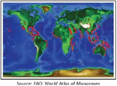
Dyes: Avicenniaofficinalis bark yields a natural dye (Banerjee et al., 1989).Bruguieragymnorrhizabark yields a black dye, which with treatment, turns orange-red, brown and violet (Wealth of India vol. 2,1988). Leaves of Clerodendroninerme,mangrove associate shrubyield brown dye (Kothari and Rao, 2002). Kandeliacandel bark is a source of dye used for dyeing clothes red and brown (ibid.).Morindacitrifolia(Kan: Ainshe, Tagase, Noni),mangrove associate tree,from the roots of 3-4years old trees natural dye extracted and used for dyeing silk, cotton and wool into red, purple and chocolate shades; since the arrival of synthetic dyes this traditional dyeing practice has almost stopped (Siva, 2007).Rhizophoramucronatabark is a source of dye (Kothari and Rao, 2002)Vitexnegundo plant ash for dyeing (ibid). Fodder: Acanthus ilicifolius iscut before flowering, spines removed and used as fodder (Wealth of India vol. I, 1985).Avicenniaofficinalis leaves, rich in protein (12.3% of dry weight) and carbohydrates (56.7%) and various minerals, used as fodder (Wealth of India vol. I, 1985); often the plants are lopped; used for feeding buffaloes.Cynodondactylon (Karki grass): Used as a fodder in coastal Uttara Kannada.Cyperusmalaccensis, abundantly present in Sharavathiriver is collected in large quantities for local use as fodder.Porteresiacoarctata,grass tolerant of high salinity isgood for fodder. Leaves of Kandeliakandel, Morindacitrifolia, Rhizophoraapiculata, R. mucronata etc. have fodder value. According to Bandaranayake (1998) mangrove fodder is considered superior due to their high salt and iodine content. Timber, firewood: Aegicerascorniculatum has Reddish brown to black wood, streaked with yellow or orange- pink used for knife handles and as stakes for oyster beds (Wealth of India, vol.I, 1985).Avicenniaofficinalisyields durable timber; for construction and oil mills (Banerjee et al, 1989).Bruguieragymnorrhiza timber is good for construction; trees grow up to 36 m found in Andamans. (ibid).Calophylluminophyllum wood for furniture and boats. Light wood of Excoecariaagallocha suitable for floats, toys etc.Morindacitrifolia is good for handicrafts. Rhizophoraapiculata,Sonneretiaalba, Thespesiapopulnea etc. yield timber. Wood of S. caseolaris is for making models, musical instruments and boats (Hajra and Sanjappa, 1996). Paper pulp: Excoecariaagallocha wood is used for making paper pulp (Banerjee et al, 1989). Bruguieragymnorrhiza wood pulp used for blotting and corrugated paper (Wealth of India, vol. 2, 1988). Seed oil for lighting, and as fuel: Seed oil of mangrove associates Cerberamanghas and Calophylluminophyllumwere traditionally used for lighting. Today the latter species, a mangrove associate, is emerging as an important biofuel source and saplings are prepared in thousands in the coastal forest divisions of Karnataka to plant along the coastal zones. Seed oil of Pongamiapinnata(mangrove associate) is also used as bio-fuel and is also being propagated in a big way. This species is also a mangrove associate. Manure: Acanthus ilicifolius is considered good manure for coconuts in coastal villages of Honavar. Leaves of Pongamiapinnata, Kandeliacandel are used as manure. Oil cake of Calophylluminophyllum used as fertilizer; it is also good to control nematicides (Wealth of India, vol. 3, 1992). Fibre: Hibiscus tiliaceus yields strong fiber from bark used for ropes, mats etc. (Kothari and Rao, 2002).Derris trifoliatayields strong fiber from the stem (Banerjee et al., 1989). Mat and basket weaving: The sedge Cyperusmalaccensis and leaves of Pandanusfascicularisare used for mat and basket weaving. Ground water protection from salinity: Sharp changes have been noticed in salt concentrations of groundwater at the interface between salt flats and mangroves implying that the mangrove systemscan modify the salinity of the groundwater by lowering it drastically (Ridd and Sam, 1996). Perfumes: Pandanusfascicularis flowers used as source of perfume.Acacia farnesiana(Kan: Kasturijali): a mangrove associate tree small tree, native of tropical America, from the bright yellow bunch of flowers yields the famous Cassie perfume of Cannes in France (Wealth of India, vol.2,1985). Tannin: Mangroves are very rich in tannins used for leather tanning, wood preservation, anti-microbial actions, manufacture of plastics, paints, ceramics and water softening agents etc. They impart flavor to wines Members of the families Avicenniaceae, Rhizophoraceae, and Sonneratiaceae are rich source of tannins (Bandaranayake, 2002). Bark of Aegicerascorniculatum, Avicenniaspp, Bruguieragymnorrhiza, Calophylluminophyllum, Kandeliacandel, Rhizophoraspp. Sonneretiacaseolaris; seed oil of Pongamiapinnata used for tanning (Banerjee et al., 1989; Kothari and Rao, 2002; Wealth of India, vol-1; 1985; Vol. 2, 1988). Netting thread is boiled with the stems and leaves of Bruguiera, to make it strong (Wealth of India, vol-2, 1988). In Uttara Kannada traditional nets are boiled with bark of Rhizophora to make them stronger. Fish food: Decomposed leaves of Avicennia marinamake good feed for fish (Banerjee et al. 1989). That fish comes to feed on decomposing Avicennia and Rhizophoraleaves in mangrove swamps has been experimentally proved by Rajendran and Kathiresan (2002). They found there was about 3 times more catch near the mangrove vegetation traps thanin control waters. Powdered leaves of Acanthus ilicifolius used as feed for fish and prawns in aquaculture. Dry weight of leaves contain 21% carbohydrates, 13.55% lipids and 1.87% protein nitrogen; leaves are also rich in minerals (Wealth of India, vol-I; 1985). Study, recreation and tourism: Mangroves, of late, are turning out to be important centres of nature study. The scenic beauty and biodiversity of estuaries with mangroves being higher, they are often centres of recreation and tourism, being used for boating and fishing, bird watching etc. in Papua New Guinea (Paijmans and Rollet, 1977). India has tremendous potential in developing coastal eco-tourism, in which well protected mangrove wetlands can play important role. Sunderban wetlands have become a paradise for tourism. With the rich bird population, healthy growth of mangroves furnishing emerald hue to the placid waters of Aghanashini during winter and summer months there exist great potential for sustainable eco-tourism. Sharavati estuary lined with mangroves has unexplored tourism potential. Potential donors of genes for salt resistance: Mangroves can be potential donors of genes for salt tolerance in crop plants. Yensen (2006) considers the 21st Century likely to be the century of halophyte agriculture expansion, as diminishing fresh water resources put pressure on civilization to utilize the vast saline soils and aquifers. Trillions of dollars are lost annually even in mildly saline fields that could be billions of dollars gained from new salt-loving crops. It has been calculated that 1.0 - 1.5 billion hectares of land are salt-affected on the earth. While much of this land occurs in the Middle East, Central Asia, Northern Africa and Australia it seems that no country is free of salinity issues. The majority (90%) of salt-affected land is naturally saline (primary salinization). Each year, approximately two million hectares still go out of productivity due to salinity. The salt-affected lands world-wide, may be resource opportunities for halotechnologies, such as halophyte crops and landscape plants, which grow better under high salinities. Miscellaneous: Acacia farnesiana, related to Karijali, is a source of gum; Avicenniaofficinalis: Wood ash mixed with paints to make the latter adhere more firmly (Wealth of India, vol-I, 1985) Barringtoniaracemosa Seeds oil and bark for bio-insecticide (Wealth of India, vol-2). Calophylluminophyllum(Kan: Honne): Seed oil used as varnish; locally used for coating fishing crafts. Used as a lubricant in place of castor oil; refined oil for soap making and for industries (Wealth of India, vol-3, 1992). Pongamiapinnata: Seed oil used for soaps (Kothari and Rao, 2002). Salvadorapersica: Twigs used as toothbrush. Soneretiacaseolaris: Spongy pneumatophores for corks and handicrafts. 1.2 Mangroves – Global scenario The influences exerted by the environmental factors such as climate and hydrological as well as other physico-chemical conditions determine the extent of mangrove distribution. One of the important factors of mangrove distribution is temperature that determines the growth and distribution of the mangroves (Chapman, 1977). Mangroves dominate approximately 75% of the world’s tropical coastline (Table 1.2) between 250N and 250S latitude (Figure 1.1). This restricted distribution of mangroves is mainly due to the sensitivity of the species to frost and cold temperature. The most northerly site of the mangrove distribution are the top of the Red Sea in the Gulf of Aquba (300N) and South Japan (320N); while the most southerly sites for mangrove distribution are Australia (380S) and Chathan island east of New Zealand (440S). The total mangrove cover of the world is about 1,81,000sq.kms. Over the period, there is significant decrease of mangrove cover in many countries due to various manmade changes and natural consequences. The highest concentration of mangrove species is, however found in the Indo-Malaysian region. The key mangrove species belong to the families Rhizophoraceae, Avicenniaceae and Sonneratiaceae. Mangroves of the world have been divided into two groups: Eastern group i.e. East Africa, India, Southeast Asia, Australia and the Western Pacific and Western group comprises of West Africa, South and North America and the Carribean Countries. Out of the ninety mangrove species of the world, 63 occur in Indian Ocean & West-Pacific regions while only 16 species are recorded in the Pacific-America, 16 species in Atlantic-America and 11 species in West Africa. In the eastern group, there are in all 20 species belonging to 9 families whereas in the Western group there are only four species belonging to 3 families. The species are Rhizophoramangal, Lagunculariaracemosa, Avicennianitida& A. tomentosaApproximately 43% of the World’s mangroves are located in just four countries- Indonesia (42,550 sq.kms), Brazil (13,400 sq.kms), Australia (11,500 sq.kms) & Nigeria (10,515 sq.kms). Table 1.2.Mangroves of the World (Source:Spalding et al, 1997)
Figure 1.1: Global distribution of mangroves 1.3 Distribution of Mangroves in India In India, mangrove vegetation is observed all along its 5,700 km coastline. The total area covered by mangroves has been estimated to be about 700,000 ha which amounts to about 6% of the world’s mangroves. However these fragile and sensitive trees and their ecosystem have been abused, neglected and overexploited in India. The major threats to mangroves are deforestation, reclamation and lately pollution also. India’s coastline can be divided into two parts viz. Western coast on the Arabian Sea and the Eastern coast on the Bay of Bengal. Western coastline includes five states, viz Gujarat, Maharastra, Goa, Karnataka and Kerala. The Eastern coastline consists of states of West Bengal, Orissa, Andhra pradesh, Tamilnadu and Andaman & Nicobar Islands. However, the distribution, extension and number of species in these areas differ according to the physiographic formation of the coast. The west coast is more or less steeply shelved, lacks major deltas and river estuaries and is dominated by sandy and rocky substratum. On the other hand, the east coast is shallow, largely influenced by major deltas and river estuaries and mostly dominated by the deltaic alluvium hence the extent of mangrove cover along the east coast of India is comparatively larger (90%) than the west coast (10%). Mangroves in India comprise of 69 species (excluding those of salt marshes and mangrove other associate species, under 42 genera and 27 families. Of these, 63 species (41 genera under 27 families) are present on the East coast; 37 species (25 genera under 16 families) on the West coast; and 44 species (28 genera under 20 families) on the Bay Islands. The East coast has 91% of mangrove species and the West coast has 53%. The most dominant mangrove species found along the east and west coast of India are Rhizophoramucronata , R. apiculata,Bruguieragymnorrhiza, B. parviflora,, Sonneratia alba, S. caseolaris, Cariopstagal, Heretieralittoralis , Xylocarpusgranatum, X. molluscensis, Avicenniaofficinalis, A. marina, Excoecariaagallocha, Lumnitzeraracemosa. The National Remote Sensing Agency (NRSA) recorded a decline of 7,000 ha of mangroves in India within the six-year period from 1975 to 1981. In Andaman and Nicobar Islands about 22,400 ha of mangroves were lost between 1987 and 1997 (Table-1.3). Over the last two decades mangrove afforestation is also being attempted, with reasonably good progress in Karnataka, more so in Uttara Kannada and Kundapur. Table. 1.3.State wise mangrove cover (in sq. km.)
1.4 Mangrove Scenario in Karnataka The coastal Karnataka is divided into 3 Districts – Dakshina Kannada, Udupi and Uttara Kannada: The Dakshina Kannada and Udupi seaboard lies between 12°27’ and 13°58’ north latitude and 74°35’ and 75°49’ east longitude. It is about 177 kilometer in lengths, about 80 kilometers at its widest part. From north to south, it is a narrow strip of territory and from east to west it is a broken low plateau, which spreads from the Western Ghats to the Arabian Sea. The major part of its length lies along the seaboard. The area is intersected by many coast parallel rivers and streams and presents varied and most picturesque scenery. The length of the coastline is almost straight, but broken at places with numerous splits by rivers, rivulets, creeks and sandy ridges and bays. Among the principle rivers of the two districts are the Netravati, Gurpur, Sitanadi, Swarnanadi, Kollur, Haladi and Chakra; and a few rivulets like Udiyavara, Shiroor and Baindur. Major estuarine complex of Dakshina Kannada and Udupi districts with sizable mangrove spread are the Netravati-Gurpur estuary, the Mulki-Pavanju estuary, the Udayavara-Pangala estuary, the Swarna-Sita-Kodi estuary, the Chakra-Hatadi-Kollur estuary, the Baindur hole estuary and the Shiroorhole estuary (Rao& Suresh, 2001). According to a report submitted by Chandran, M.D.S. (2007-unpublished) to EMPRI, Bangalore, based on survey of 11 estuaries 14 mangrove species were observed (Table 1.4). The Table shows that highest number of mangroves (14 sp.) is found in the Kali estuary, followed by Haladi-Chakra-Kollur estuary (12 sp.) Aghanashini and Mulki-Pavanje (11 sp. each), Gangavali, Venktapur and Udyavara (10 sp. each) and the remaining with lesser numbers. The bigger estuaries tend to have more numbers, an exception being Netravati-Gurpur (7 sp.). In the Sharavati estuary, because of constant release of fresh water from the hydel projects from upstream the salinity level is very low and therefore we do not find high salinity tolerant species like Avicennia marina and Rhizophoraapiculata. Low salinity to nearly fresh water conditions favour good growth of Sonneratiacaseolaris throughout the estuary, except towards its very mouth. All the estuaries of Honavar Forest Division do not have Lumnitzeraracemosa and Bruguieracylindrica. A lone tree and few saplings of Bruguieragymnorhizawere found growing in Venktapur estuary, being absent in other estuaries of the Division. Some of the other mangroves associated with lower salinity conditions are Kandeliacandel, Acrostichumaureum and Acanthus ilicifolius. Table-1.4. Estuary-wise distribution of mangroves in Karnataka
Dakshina Kannada: 1. NG: Netravati-Gurpur; 2. MP: Mulki-Pavanje. 1.5 Mangrove Scenario in Uttara Kannada District The Uttara Kannada District Sea Board lies between 74° 9’ to 75°10’ east longitude and 13° 55’ to 15° 31’ north latitude and extends over an area of 10,327 Sq. km. The district has three main and distinctive regions: the Coastlands, the Sahyadri range and Eastern margin where the tableland begins. Relief and climate have introduced these regional differences. The coastlines are the best-developed area with a high degree of economic development and a high density of population. It is in this region, Karwar, Ankola, Kumta, Honavar and Bhatkaltaluks are located. The five important rivers of Uttara Kannada are Kalinadi, Gangavali, AghanashiniSharavathi and Venktapur. Notable rivulets/creeks are Belekeri, Ankola, Alvekodi and Badgani. The mouths of rivers and rivulets have several mangrove habitats. Uttara Kannada District experiences typical tropical climate. There are no cold months. Yet the higher reaches of the Ghats [around 800M] experience a cooler climate than the coast. The rainfall varies from about 300 cm or more along the coast and the Ghats, down to 100 cm along the eastern fringes. Most of the rainfall is monsoonal & falls from June to August. Weather from December to April will be invariably dry. Summer temperature can go beyond 40°C in some places. The types of soils in these Taluks are Black cotton soil, Red loam, Black clay & forest soil. Details of Division-wise area under forests are given in Table 1.6 The mangrove zone towards the river mouth, having higher salinity, is known as ‘euhaline’. Along the coast of Uttara Kannada, the river mouths are rocky and with strong wave action, and not suitable for mangroves. This is unlike the deltaic river mouths of the east coast, where mangroves can grow luxuriantly. The euhaline zone has salinity range from 30 ppt to 40 ppt. The zone behind is called ‘polyhaline’ where the wave action is less and salinity ranges from 18 ppt to 30 ppt. The substratum is sandy clay. This region is ideal for mangroves like Sonneratiaalba, Rhizophora spp., Avicenniaspp., Bruguiera spp., Acanthus ilicifolius etc. The third zone, still behind is ‘mesohaline’ where salinity ranges from 5 ppt to 18 ppt. It has silty clay bottom and feeble wave action. The mangroves of this zone are Kandeliacandel, A. ilicifolius, Rhizophora spp., Aegicerascorniculatum, S. alba etc. (Rao and Suresh, 2001).The estuary-wise list of mangroves in HonavarForest Division is given in Table 1.5. Table 1.5. Distribution of mangroves in Honavar Forest Division (*present)
1.6 Forest Administration Kanara Circle: The Kanara Circle came into existence on 1st January 1967 with headquarters at Dharwad. The headquarters was shifted to Sirsi in 1993. Its territorial jurisdiction covers the entireUttara Kannada District. The Circle has6 Territorial Forest Divisions, 1 Wild Life Division and 1 Social Forestry Division with the headquarters respectively at Haliyal, Honavar, Karwar, Sirsi, Yellapur, Dandeli&Karwar (Figure 1.2). The territorial divisions are divided into 14 Sub-divisions. The Wild Life Division, Dandeli has 2 Sub-divisions,Dandeli&Anshi. The Circle has 39 territorial Ranges and 10 S.F headed by Range Forest Officers. There are 155 Sections under Foresters & 477 Beats headed by Forest Guards. The Government Timber Depots in the Circle are situated at Dandeli, Kirwatti, Mundgod, Kadra, Hattikeri, Katgal, Idugunji, Kabbinhakkal, Chipgi&Manmane. The Govt. Timber Depot at Dandeli, Kirwatti&Mundgodare managed by Asst. Conservator of Forests & others by Range Forest Officers. Table. 1.6. Division-wise total forest in Kanara Circle
Source: ADM Report Kanara Circle 2010
1.6 Methods: Inventorying and mapping of mangroves involved
Figure 1.2.Kanara Circle Area calculation using GIS: Step 1: Mangrove areas(areas under canopies of mangrove crowns) and Potential areas(exposed areas during low tides, without mangrove crowns, excluding seasonal sand bars and bivalve beds) havebeen digitized as separate vector polygon layers using Google Earth, Bing map & Geo-referenced IRS images. Step2: These polygons (regions) are overlaid on forest ADM vector maps& village vector maps (based on Census 2001) and split using polygon split into smaller units in correspondence with forest beat as an ADM unit. Step3: Each region’s spatial tables are updated with coordinate extractor, region area (in ha) and perimeter. Data is converted in to GPX format and uploaded into GPS. Step4: Using GPS,sample regions are surveyed for species distribution & some decisive hydro-biological parameters, especially salinity and associated mangroves, incorporated in the region. Using this dataIsolines are created for possible distribution of such parameters in the estuaries and creeks studied. |
||||||||||||||||||||||||||||||||||||||||||||||||||||||||||||||||||||||||||||||||||||||||||||||||||||||||||||||||||||||||||||||||||||||||||||||||||||||||||||||||||||||||||||||||||||||||||||||||||||||||||||||||||||||||||||||||||||||||||||||||||||||||||||||||||||||||||||||||||||||||||||||||||||||||||||||||||||||||||||||||||||||||||||||||||||||||||||||||||||||||||||||||||||||||||||||||||||||||||||||||||||||||||||||||||||||||||||||||||||||||||||||||||||||||||||||||||||||||||||||||||||||||||||||||||||||||||||||||||||||||||||||||||||||||||||||||||||||||||||||||||||||||||||||||||||||||||||||||||||||||||||||||||||||||||||||||||||||||||||||||||||||||||||||||||||||||||||||||