GRASSLANDS OF ANSHI-DANDELI TIGER RESERVE - Study method
The grasslands of the ADTR were mapping through the IRS P6 - remote sensing data (Google Earth etc.) and field survey. Representative patches for all types of grasslands or rather grass growing areas, including marshes, puddles, forest underneath etc. were studied using ecological sampling technique ‘transect cum quadrat method’. In each selected grassland 5 plots (quadrats), each 1 m x 1m (Figure 4.1), were laid along a straight line (transect line) leaving a distance of 10 m between any two plots (Figure 13). We have characterized grasslands as short (<15 cm height), medium (16-30 cm) and tall (>30 cm). In each plot, grasses and other herbs were noted and their numbers counted. Data on their habit (clumps, trailing, erect etc.) and notable field characters were also recorded. Searches were made outside the sample plots to document other species. Rare and unidentified specimens were pressed for herbaria. Geographical co-ordinates of study localities were recorded using global positioning system (GPS). Fresh specimens were identified with the help of floras and our own herbarium specimens. Experts were consulted for unidentified collections; some of the specimens were also taken to the BSI herbarium at Pune. Bamboos and reeds, though also grasses, have not been included in this study as they do not form part of grasslands. The locations of sampling are given in Figure 4.2. The grasslands studied in different localities have been characterized and the details are given in Table 4.1. A typical grassy blank in the forest is shown in Figure 4.3.
Table 4.1: Transect locations in Anshi and Dandeli Tiger Reserve and grassland type
| Sl. |
Transect locality |
Grassland type |
Dry/Wet |
| 1 |
Goyar-Savadi |
Forest underneath* |
Dry |
| 2 |
Kailwada-Dongrewada |
Grassland adjacent to fields |
Dry |
| 3 |
Kailwada – Kailwada |
Fallow fields |
Dry |
| 4 |
Kailwada-Madgaon |
Grassland adjacent to fields |
Dry |
| 5 |
Thayamaddi-Barpoli Cross (Anshi) |
Hill slope grassland |
Dry |
| 6 |
Burpalli (Anshi) |
Open grassland |
Dry |
| 7 |
Shiroli-near Bamnia (Kumbarwada) |
Wet grassland |
Wet |
| 8 |
Terali |
Forest opening grassland |
Dry |
| 9 |
Kundal |
Forest opening grassland |
Dry |
| 10 |
Kaneri dam site |
Forest opening grassland |
Dry |
| 11 |
Virnoli safari route |
Forest underneath* |
Dry |
| 12 |
Shiroli mining area (Kulagi) |
Wet grassland |
Wet |
| 13 |
Mandurlli (Kulagi) |
Wet grassland |
Wet |
| 14 |
Bommanahalli Reservoir |
Reservoir side grassland |
Dry |
| 15 |
Lande |
Forest opening grassland |
Dry |
| 16 |
Anshi |
Forest opening grassland |
Wet |
*Forest underneath: Sparse growth of certain grasses occurs beneath forest canopies.
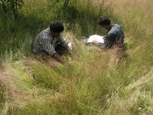
Figure 4.1: Laying quadrat in Dimeria and Arundinella dominated grassland in Kundal
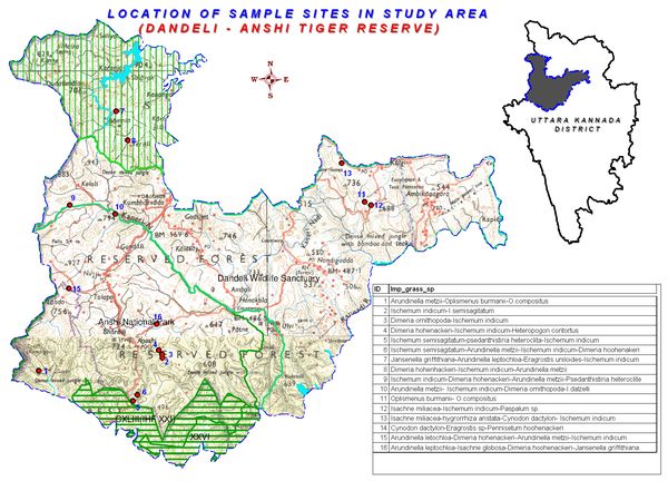
Figure 4.2: Grasslands study locations in ADTR
Opportunistic surveys: Grasses occurring in many minor habitats other than grasslands such as old walls, alongside water courses, wastelands, cultivations, crevices in rocks etc., were also listed.
- Wall grasses: The monsoon rains promote a flourish of seasonal grasses on mud walls, stone fences, old compound walls, abandoned houses etc. The commonest among these wall grasses are Arthraxon lancifolius, Dimeria ornithopoda, Arundinella pumilla etc.
- Grasses along water courses: Paspalum conjugatum, Hygrorrhiza aristata, Leersia hexandra, Sacciolepis interrupta, Isachne miliaceae, etc. occur along water courses.
- Fallow land grasses: The fallow lands of the village areas are dominated by grasses like Panicum repens, Dactyloctenium aegyptium, Eragrostis uniloides, Paspalum scrobiculatum etc.
- Grasses as weeds: Several grasses occur as weeds in fields and gardens. Notable of them are Echinochloa colona, E. crusgalli, Oryza rufipogon, Sacciolepis interrupta etc., associated with rice fields. Weeds in gardens and other croplands include Panicum repens, Dactyloctenium aegyptium, Centotheca lappacea and Ischemum indicum.
Results (using sample plots)
Based on 16 transects and 80 plots (each of one sq.m) we recorded 116 flowering plant species, belonging to 109 genera and 36 families There were 100 herb species belonging to Poaceae (grasses) and its close relative Cyperaceae (sedges). Eight shrub species, seedlings of six tree species and two climber species were also recorded. Poaceae with 32 species was the largest and dominating family followed by Cyperaceae (13 sp.), Scrophulariaceae (8), Asteraceae (6), and Acanthaceae (5) and others in smaller numbers. The notable grasses of different grasslands sampled are given in Table- 4.2
Population: Terali grassland (Figure 4.4) had the highest number of individuals (3800/transect) followed by Kailwada-Kailwada (3022) (Figure 4.5) and others. Terali has many grasslands, rich in fodder grasses dominated by Dimeria hoohenackeri, Ischemum indicum, and Arundinella metzii, all these endemic to Peninsular India. The fallow fields of Kailwada-Kailwada under heavy grazing pressure from cattle, are dominated by weedy species of sunflower family, Asteraceae. If fallow period continues and grazing pressure reduced this area could be transformed into good grasslands. Most fallow fields of the ADTR are of similar kind. The fenced bena lands near paddy fields are naturally having tall grasses cherished as good fodder by villagers.
Table 4.2: Grassland study locations and notable grass species.
| Sl. |
LOCATION |
Important grass species |
| 1 |
Anshi |
Arundinella leptochloa-Isachne globosa-Dimeria
hoohenackeri-Jansenella griffithiana |
| 2 |
Bommanahalli reservoir |
Cynodon dactylon-Eragrostis sp-Pennisetum hoohenackeri |
| 3 |
Burpalli-Anshi |
Ischemum semisagitatum-Arundinella metzii-Ischemum indicum-Dimeria hoohenakeri |
| 4 |
Goyar-Savadi |
Arundinella metzii-Oplismenus burmanii-O.compositus |
| 5 |
Kailwada – Kailwada |
Dimeria ornithopoda-Ischemum indicum |
| 6 |
Kailwada-Dongrewada |
Ischemum indicum-I.semisagitatum |
| 7 |
Kailwada-Madgaon |
Dimeria hohenackeri-Ischemum indicum-Heteropogon contortus |
| 8 |
Kaneri damsite |
Arundinella metzii- Ischemum indicum-Dimeria ornithopoda-I.dalzelli |
| 9 |
Kundal |
Ischemum indicum-Dimeria hohenackeri-Arundinella metzii-Psedanthistiria heteroclite |
| 10 |
Lande |
Arundinella letochloa-Dimeria hohenackeri-Arundinella metzii-Ischemum indicum |
| 11 |
Mandurlli (Kulagi) |
Isachne miliacea-hygrorrhiza aristata-Cynodon dactylon- Ischemum indicum |
| 12 |
Shiroli mining area |
Isachne miliacea-Ischemum indicum-Paspalum sp. |
| 13 |
Shiroli-near Bamnia |
Jansenella griffithiana-Arundinella leptochloa-Eragrostis uniloides-Ischemum indicum |
| 14 |
Terali |
Dimeria hohenhackeri-Ischemum indicum-Arundinella
Metzii |
| 15 |
Thayamaddi-Barpoli Cross |
Ischemum semisagitatum-psedanthistiria heteroclita-Ischemum indicum |
| 16 |
Virnoli safari route |
Oplismenus burmanii- O.compositus |
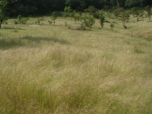
Figure 4.3: A typical hill slope grassland
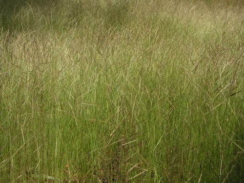
Figure 4.4: Dimeria hohenakeri dominated grassland in Terali
Species richness: Figure 4.6 shows species richness of different transects.Shiroli-Bamnia had the highest number of species (43). Marshy spots with characteristic herbs contribute to its species richness. Drier highlands of Shiroli-Bamnia had perennial grasses like Arundinella leptochloa and seasonal Dimeria hoohenackeri, Ischaemum indicum etc. all of fodder value.Diggie area, newly added to ADTR, has some good and large grasslands, followed by Anshi transect (39 species), also with marshy plots. Anshi region is mostly clad in evergreen to semievergreen forests. There are fairly large agricultural areas cum grassy blanks, within these forests.
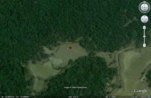
Figure 4.5: Kailwada–Kailwada grassland & fields (from Google Earth)

Figure 4.6: Transect-wise species richness in ADTR
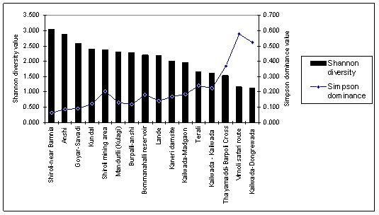
Figure 4.7: Transect-wise Shannon diversity and Simpson dominance in ADTR
Details regarding Shannon diversity and Simpson dominance of the grasslands are given in Figure 4.7. Terali open grassland though low in Shannon diversity index (1.65) was dominated by fodder grasses. Shannon diversity was higher in forest underneath grassland of Goyar (2.5), open grassland (Figure 4.6) of Kundal (2.4), wet grasslands of Shiroli- old mines area (2.4) and Mandurli near Kulgi (2.3).
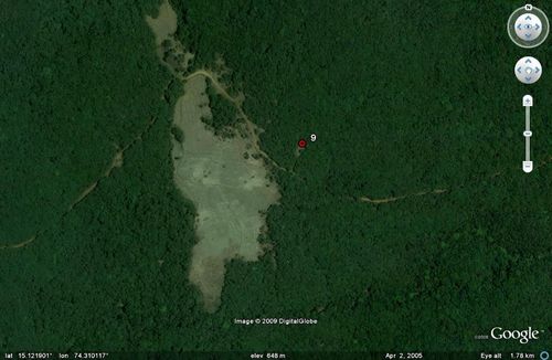
Figure 4.8: Kundal forest opening and nearby large fields
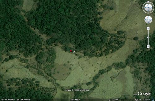
Figure 4.9. Kailwada-Dongrewada – highly fragmented landscape
In Goyar though species number was high (20) grasses constitute only 40%, and that too of not much fodder significance such as Oplismenus burmanii and O. compositus, which by habit creep on the forest floor amidst other non grass herbs. The same was the case with Shiroli old mines area. Forest transect along Virnolli (safari route), and fallow fields of Kailwada-Dongrewada study area (Figure 4.9) had the lowest Shannon diversity indices at 1.166 and 1.129 respectively. Bommanahalli reservoir grassland had a moderate Shannon diversity of 2.21. The number of grass species here was poor and their fodder significance less, understandably due to constant fluctuation of water level in the dam. Diversity was very poor and dominance very high in Virnolli (safari route) with 75% of population constituted by single short grass species of Oplismenus burmanii. Kailwada-Dongrewada also had very high dominance with Ischaemum indicum but this grass has good fodder value. Percentage of grass species versus non-grass species for different study sites are given in Figure 4.10. It was observed that habitat heterogeneity at the micro-level within the grassland causes increase in the number of species, but need not be reflecting the pasturage value of the grassland.
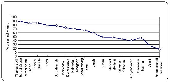
Figure 4.10. Grass individuals (%) compared to non-grass individuals (%) in the samples


