| |
ENVIS Technical Report: 36, February 2012 |
 |
Grasslands of Anshi-Dandeli Tiger Reserve |
 |
|
|
GRASSLANDS OF UTTARA KANNADA
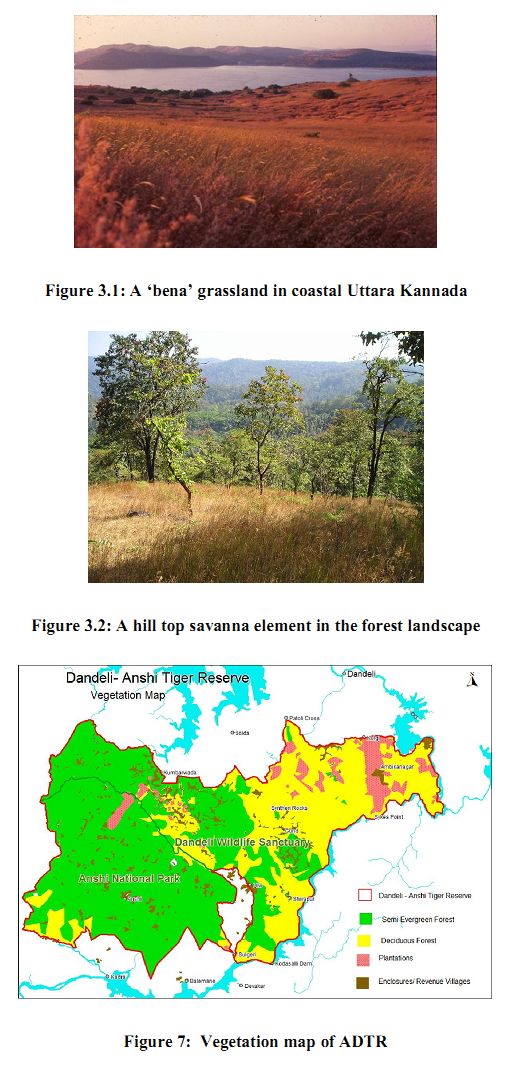
Uttara Kannada district (74o 9’-75o 10’ E and 13o 55’-15o 31’ N), having 10,327 sq km area is bordered by the Arabian Sea to the west. Most of the district is covered by the low altitude (<800 m) hills of Central Western Ghats. The South-west Monsoon brings to the western parts of the district, up to the crestline, copious rainfall ranging from 3000-5000 mm per annum. As the Ghats cause most of the clouds to precipitate towards the west, there is dramatic decline in rainfall towards the rain-shadow eastern portions; just 40 km east of the crestline the rainfall would be less than 1500 mm. The rainfall over the district is highly seasonal, with more than 90% occurring in June-November. Mean monthly temperature range from 20-27o C. The net result is an effective dry season of almost six to seven months. The western portions of the district with higher rainfall tend to have evergreen to semi-evergreen forests as the natural climax vegetation, in the absence of human interference. The eastern undulating landscape merging with the Deccan Plateau, in the taluks of Mundgod and Haliyal tend to have moist deciduous to dry deciduous forests as the climax forests. The grasslands in the district are mainly due to the forest clearance by humans carried out through centuries of shifting cultivation and cattle grazing. Specially maintained ‘bena’ grasslands (Figure 3.1) of farmers as well as many grassy blanks within forests and closer to villages are the result of arresting the natural succession of forest vegetation because of periodic burning of woody growth by the people. Savanna vegetation (Figure 3.2) is very common element of landscape in every taluk of the district. It is a mixture of isolated trees or clumps of dwarf trees amidst a general matrix of grasses. In the absence of fire these savannas often tend to progress towards forest, through recruitment of more trees, which shade the grasses, giving not much scope for their multiplication.
Man-made savanna grasslands: Pollen grain deposits in swamps and marshes and in the seabed along the coastline are often indicators of the past vegetation and the changes that happened in the course of time. We do not have much of pollen deposit studies from Uttara Kannada. However, one outstanding study by Caratini et al. (1991) based on a soil core sample from the sea bottom off the Karwar coast shows that the land was covered until 3,500 years ago by forests dominated by evergreen trees. Thereafter the pollen deposit from savanna plants such as grasses and herbs increased. Such change would indicate the human impact on the forests of Uttara Kannada by slash and burn method or shifting cultivation or kumri cultivation (Chandran, 1998). Climatic conditions would still favour return of the forests on fallow or abandoned agricultural lands. Cattle rearing also contributed to savanna formation; as humid weather promoted the growth of forests in savannas and grasslands, the farmers were forced to keep forests away by periodical burning of woody outgrowth.
Grassland types in Uttara Kannada: The savanna grasslands can be mainly categorized into two types:
- Dry to mesophilous grasslands occur along the rocky plateau, open hill tops and slopes, scrub jungles, forest undergrowth and openings, uncultivated lands, fallow fields etc. The mesophyllous grasslands occur in more moist conditions than the dry land grasses. Those in gardens, rice field bunds, wet meadows etc. are of this type.
- Hygrophilous grasslands are more water-loving and seen along the margins of water courses like pools, puddles, back waters, along marshy places, low lying areas etc.
In both these grassland categories, depending upon human pressures, topography, soil nature and grazing pressure short or long type grass species would occur. Human factor is decisive factor governing the permanency of grasslands, but for which vegetation would change in most cases according to the principles of ecological succession. Based on Sarmiento, 1984on these factors Savannas can be differentiated as:
- Savannas without woody species taller than the herbaceous stratum: Grass savannas or grasslands.( e.g., Benas; Figure 3.1)
- Savannas with low (less than 8 m) woody species forming a more or less open layer.
- Shrubs and/or trees isolated or in groups; total cover of woody species less than 2%: Tree and shrub savanna (e.g., Coastal scrub savannas)
- Total tree/shrub cover between 2% and 15%: Savanna woodland, wooded grassland, or bush savanna
- Tree cover greater than 15 %: Woodland (e.g., Interior Coastal scrub savannas, and hill top grasslands)
- Savannas with trees over 8 m
- Isolated trees with less than 2% cover: Tall- tree savanna (Lands near agricultural fields)
- Tree cover 2-15%: Tall savanna woodland (Eg.,Scrub lands)
- Tree cover 15-30%: Tall wooded grassland (Highly degraded deciduous forests, Soppina Bettas)
- Savannas with tall trees in small groups: Park savanna
- Mosaic of savanna units and forests: Park (Forest hill slope grassland, forest openings, etc.).
Figure 9: A coastal wetland grassy area mixed with the sedge Cyperus pedunculatus
|
|