Floods in the City
Purpose of assessment
Burgeoning human population coupled with the increased urban concentration has escalated both the frequency and severity of disasters like floods, etc. With the tropical climate and unstable land forms, coupled with land use changes, unplanned growth proliferation non-engineered constructions make the disaster-prone areas mere vulnerable. In this regard basic policy statements as part of comprehensive development plan of a region need to address:
- Protect life and health
- Minimising property losses
- Enhance floodplain use
- Ensure a functional drainage systems
- Encourage aesthetics
- Curb large scale land use changes in the immediate vicinity of waterbody catchment
- Guide development
This entails appropriate strategies for natural resources planning, development and management by adopting an integrated approach for a hydrological unit such as lake catchment, incorporating quantity, quality and environmental considerations (Ramachandra, 2007). Development projects and investment proposal has to be formulated and considered within the framework of lake catchment, river or sub-basin plan so that the best possible combination of options can be obtained for poverty alleviation, increasing incomes and productivity, equity, reduced vulnerability to natural and economic risks and costs (Ramachandra, et al., 2007). Solutions to water allocation and planning issues will be found adopting a demand management approach.
Techniques adopted for assessment include data collection (primary and secondary data), analysis (remote sensing and collateral data) and interpretation.
INCIDENCE DESCRIPTION
Unplanned urbanisation has drastically altered the drainage characteristics of natural catchments, or drainage areas, by increasing the volume and rate of surface runoff. Drainage systems are unable to cope with the increased volume of water and are often encountered with the blockage due to indiscriminate disposal of solid wastes. Encroachment of wetlands, floodplains, etc. obstructs floodways causing loss of natural flood storage. Damages from urban flooding can be grouped into two categories:
- Direct damage—typically material damage caused by water or flowing water.
- Indirect damage—social consequences that are negative long term effects of a more psychological character, like decrease of property values in frequently flooded areas and delayed economical development, for e.g. traffic disruptions, administrative and labour costs, production losses, spreading of diseases, etc.
Urban flooding creates considerable infrastructure problems and huge economic losses in terms of production, as well as significant damage to property and goods. Flooding in urban areas causes large damage at buildings and other public and private infrastructure. Besides, street flooding can limit or completely hinder the functioning of traffic systems and has indirect consequences such as loss of business and opportunity. The expected total damage; direct and indirect monetary damage costs as well as possible social consequences is related to the physical properties of the flood, i.e. the water level above ground level, the extend of flooding in terms of water volume escaping from or not being entering the drainage system, and the duration of flooding. With sloped surfaces even the flow velocity on the surface might have an impact on potential flood damage. Precipitation, intensity and the duration of time are the key elements that decide flooding. Sometimes even 8 cm to 10 cm of rainfall in a short span of time have resulted in flooding, and if it occurred in a matter of one or two days, the water seeps into the soil, in the case of mixed land use (urban, vegetation). Even a 30 mm rainfall in a matter of 30 minutes could cause flooding, especially in the low-lying areas, due to intense urbanisation. Frequent thunder showers accompanied by squall and hail being the characteristic of the month of May, resulting in the uprooting of trees.
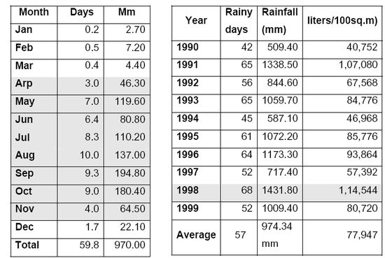
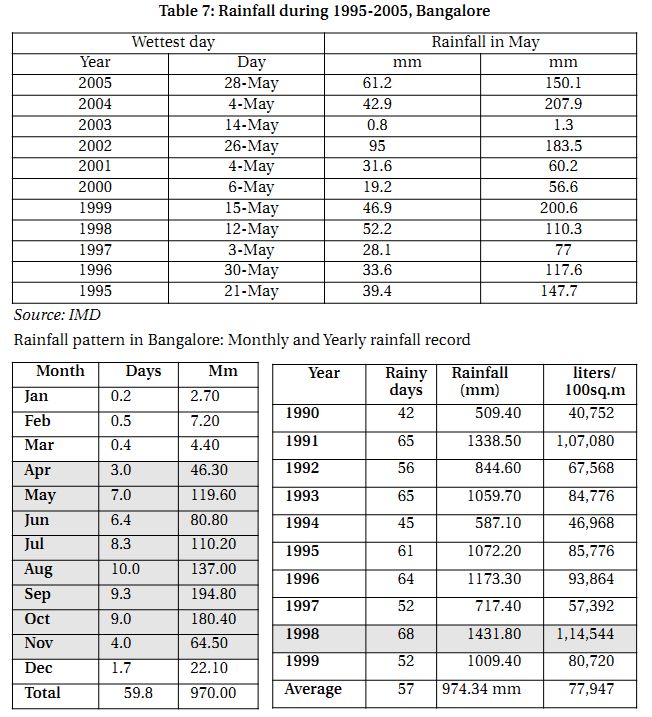
The highest rainfall recorded on a single day has been 10 cm during the month of May in 2002 (Table 7.1). The closest in record to this was 9 cm recorded in 1991 on a single day. Earlier, 1999 witnessed 200.6 mm rainfall and the lowest rainfall recorded has been 1.3 mm in 2003. The heaviest rainfall in 24 hours has been 153.9 on May 6 1909. As the development of land use in urban areas, less water can be absorbed by the soil and the volume of urban stormwater is increasing. This escalating volume of urban runoff not only increases pollution, it elevates the risk of flooding. The amount of urban runoff is largely a factor of rainfall and the amount of paved area. As paved area increases – for example, due to vegetation clearing, new housing or industrial developments, urban infill, paving driveways, patios, new roads etc., so does the amount of runoff.
Table 7.1: Rainfall during 1995-2005, Bangalore
| Wettest day |
Rainfall in May |
| Year |
Day |
mm |
mm |
| 2005 |
28-May |
61.2 |
150.1 |
| 2004 |
4-May |
42.9 |
207.9 |
| 2003 |
14-May |
0.8 |
1.3 |
| 2002 |
26-May |
95 |
183.5 |
| 2001 |
4-May |
31.6 |
60.2 |
| 2000 |
6-May |
19.2 |
56.6 |
| 1999 |
15-May |
46.9 |
200.6 |
| 1998 |
12-May |
52.2 |
110.3 |
| 1997 |
3-May |
28.1 |
77 |
| 1996 |
30-May |
33.6 |
117.6 |
| 1995 |
21-May |
39.4 |
147.7 |
Source: IMD
Rainfall pattern in Bangalore: Monthly and Yearly rainfall record
Increasing urbanization has led to significant changes in the natural systems. These changes include alterations in the hydrologic flow regime as well as shifts in the chemical and biological makeup of stormwater runoff from these developing areas. As an area is developed, the natural ability of the catchment to withstand natural hydrologic variability is removed. Infiltration capacity is decreased due to the increase in impervious surface and disrupted native soils and vegetation. Natural retention and detention capabilities of a catchment are removed through channelization of natural waterways and the installation of formal drainage systems such as pipes and gutters (Vijay Kulkarni and Ramachandra, 2006). Anthropogenic activity also introduces chemical and biological constituents to the catchment.
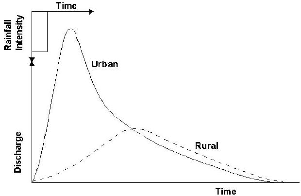
Increased peak discharges for a developed watershed can be two to five times higher than those for a watershed prior to development (Figure 12.1). The changes in the rates and amounts of runoff from developed watersheds directly affect the morphology, or physical shape and character, of creeks and streams (Figure 12.2). Some of the impacts due to urban development include: Stream widening and bank erosion, stream down cutting, changes in the channel bed due to sedimentation, increase in the floodplain elevation. Urban floods differ from those in natural basins in the shape of flood hydrographs (Figure 12.1), peak magnitudes relative to the contributing area, and times of occurrence during the year. The imperviousness of urban areas along with the greater hydraulic efficiency of urban conveyance elements cause increased peak stream flows but also more rapid stream response. Summer floods resulting from high intensity thunderstorms are more common in urban areas. Infiltration and evapotranspiration are much reduced at this time of the year under developed conditions (Prasad, et al., 2002, Ramachandra, 2002, WHGM, 2003).
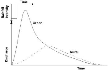
Figure 12.1: Flood Hydrographs for Urbanized and Natural Drainage Basins
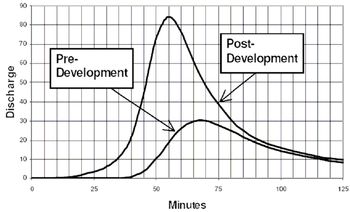
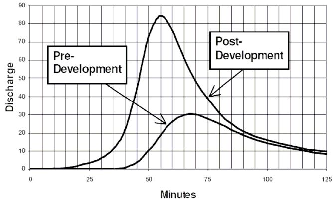
Figure 12.2: Runoff Hydrograph under Pre-and Post-Development conditions
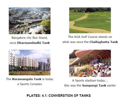
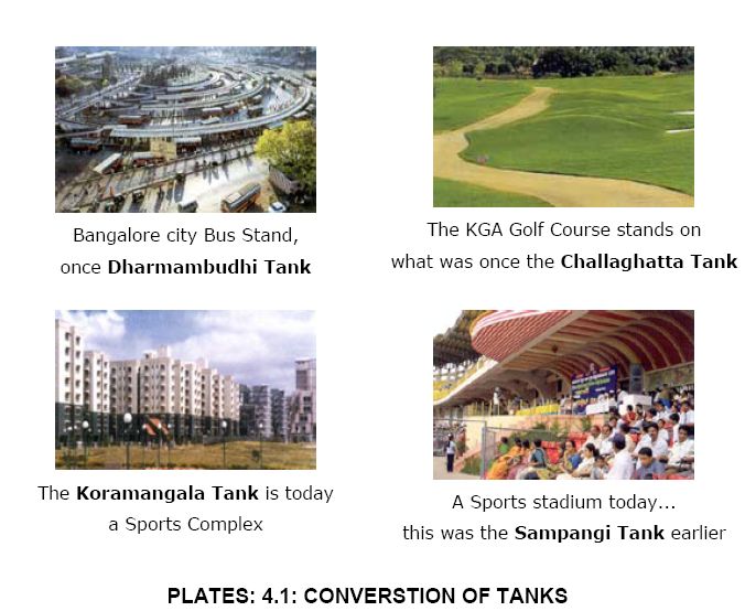
Some of the impacts due to urban development include: reclamation of lakes (Plate 4.1), stream widening and bank erosion, stream down cutting, changes in the channel bed due to sedimentation, increase in the floodplain elevation (Figure 12.3). Urban floods differ from those in natural basins in the shape of flood hydrographs (Figure 12.1), peak magnitudes relative to the contributing area, and times of occurrence during the year. The imperviousness of urban areas along with the greater hydraulic efficiency of urban conveyance elements cause increased peak stream flows but also more rapid stream response (WHGM, 2003). Summer floods resulting from high intensity thunderstorms are more common in urban areas. Infiltration and evapotranspiration are much reduced at this time of the year under developed conditions.

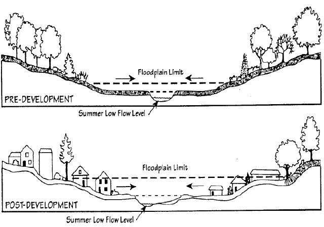
Figure 12.3: Change in Floodplain Elevations
Thus, flooding is a consequence of the increase in impervious area due to land use changes in the catchment from open space to impervious surfaces with the high-density urban developments. This is coupled with lack of drainage upgrade works with the changes in enhanced run-offs, the encroachment and filling in the floodplain on the waterways, obstruction by the sewer pipes and manholes and relevant structures, deposits of building materials and solid wastes with subsequent blockage of the system and also flow restrictions from under capacity road crossings (bridge and culverts).
The lack of planning and enforcement has resulted in significant narrowing of the waterways and filling in of the floodplain by illegal developments. This has subsequently caused flooding to other properties that have not previously been flooded, new properties in the flood plain built below the high flood marks (designated flood levels), these being frequently flooded and restrictions of options for future flood mitigation including widening of waterways.
Pre-incidence scenario
Urban floods are linked to the total lack of attention to the nature of region’s hydrological system. Despite the knowledge of occurrence of heavy downpours and its frequency, the natural drainage channels are not maintained, catchment area of lakes and lakes have been allowed to be encroached by land mafia in connivance with the government machinery. This is something our ancestors knew but our current urban planners and politicians don’t worry about such mundane things (http://www.rainwaterharvesting.org/ catchwater/oct2000/newslet9_1.htm,http://www.downtoearth.org.in/editor.asp?foldername = 20000930&filename=Editor&sec_id=2&sid=1).
Urban flooding is not a new phenomenon. Increasingly, more and more cities and towns face waterlogged streets. Post 2000 have witnessed, even relatively small downpours are enough to clog up drains, fill up streets and disrupt life and the study proved that unchecked construction of big buildings, loss of open spaces, and clogged drains were the cause.. Meanwhile, cities continue to face water scarcity and the water tanker business continues to grow. Bangalore is just one example of bad water management practices. Years of siltation of tanks have reduced their water storage capacity. Encroachments of nalas, lakes and other waterbodies, choking of streams and stormwater drains have taken their toll. There is a need for urban areas to improve water management. Urban water harvesting offers a solution to deal with meeting water demand as well as reducing the intensity of urban flooding. Thus, the urbanization process and the hydraulic insufficiency of drainage systems are two of the most common causes of urban flooding.
Development and redevelopment of the district, by nature increases the amount of imperviousness in the surrounding environment. This increased imperviousness translates into loss of natural areas, more sources for pollution in runoff, and heightened flooding risks. In recent decades, stormwater runoff has emerged as an issue of major concern. Stormwater affects local waterways both in terms of the volume of runoff that is generated, and the nature of the pollutants that may be conveyed. Allowing stormwater to infiltrate in urban residential areas is one of the major ways for urban floods.
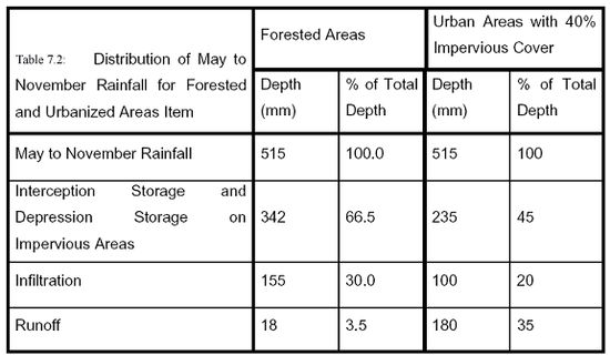
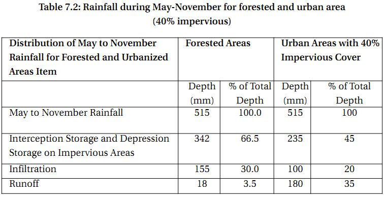
A major consequence of the increase in impervious area which accompanies urbanization is an increase in direct runoff and a corresponding decrease in infiltration. Table 7.2 illustrates the changes in hydrological components that result from developing a forested area. Urbanization also results in decreased evapotranspiration. The net effect of conventional development practices on an urban stream is a dramatic change in the hydrologic regime of the stream
Table 7.2: Rainfall during May-November for forested and urban area (40% impervious)
The downstream urban flooding problem has become acute during the past thirty years as communities have grown and as curbed roadways (paved channels) have been installed in both new suburban areas and throughout older areas that formerly provided runoff-retarding storage in roadside swales or ditches. Amelioration of the unfortunate results of past urbanization requires very large investments to construct additional flood control works. Where flood control is infeasible, the flooding hazard reduces property values and may lead to abandonment, which is unacceptable.
Response & loss summary
The survey carried out by BWSSB in Bangalore reveals that few households from the peri-urban and the Green Belt areas reported that their houses had been flooded in the recent past, suggesting that high density of houses and unplanned urbanisation have contributed to the problem of improper drainage in the Corporation Area. Major highlights of the survey are:
- 7% of households reported that they faced instances of flooding;
- 10% of households of lower socio-economic status reported that they had faced flooding in the past decade – instances of flooding had been more common in the central part of the city;
- Of the households that had experienced flooding, 72% reported such occurrences in the last one year, 15% had experienced flooding in the year 1999, 7% during the period 1995 to 1998, while 2% reported that they had experienced flooding prior to 1995;
- Of the households that had experienced flooding, a majority said that the effects had lasted for one to three days, while 3% said they had extended beyond a week;
- Two thirds of the households ascribed the reasons for flooding to blockages in the sewerage system, 12% to ingress of rainwater into the house, while 11% said that it had been caused by a blocked drain or gutter;
- Lower income households and those living in the slums were more vulnerable to flooding caused by blocked drains; and
All households reported damage to assets and loss of workdays on account of such flooding. Majority of these affected communities are engaged in daily wage labour or small-scale retail activities. Flooding and the resultant disruption of mobility have a direct impact on the incomes of the households. Their ability to cope with such disturbances is much lower than that of other socio-economic groups who have larger social and economic security nets to fall back upon. Women, children and the elderly are most vulnerable to hazards of poor environmental sanitation, as they spend more time in the house and its vicinity than adult men who have greater mobility and often spend little time within the house or the neighbourhood.
In addition to this, newspaper reports in response to rain havoc (one such example on May 28, 2005, Plate 4.2)
- A woman and a man were killed (http://www.thisismyindia.com/ pictures_of_india/bangalore-pictures.html)
- Heavy water logging was reported from 35 areas in southern and eastern parts of the city
- The Fire and Emergency Services had to press in 20 vehicles to clear uprooted trees and pump out water in flooded areas
- 434 electric poles were uprooted. BESCOM suffered a loss of Rs. 4.8 crore
- A number of trees were uprooted, damaging a BMTC bus, a car and three other vehicles
Litter, building debris, sediments and solid waste are the main causes of blockages of the drainage system and subsequent floodinge. Therefore, minimising flooding and the establishment of clean healthy waterways are some of the many benefits which can be achieved through appropriate solid waste and catchment management practices by reducing pollution from the sources. BWSSB’s Sewer Division has, over the last two years, carried out de-silting of the 2000 mm diameter outfall sewer including sewer section through Ejipura – where much of the silting up was caused by local residents breaking into the sewer to release flood water.
Similar past incidences
[Source: http://www.thisismyindia.com/pictures_of_india/bangalore-pictures.html]
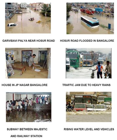
Plate 4.2: Rain havoc in Bangalore during 2005 and 2007
Various factors responsible for the floods
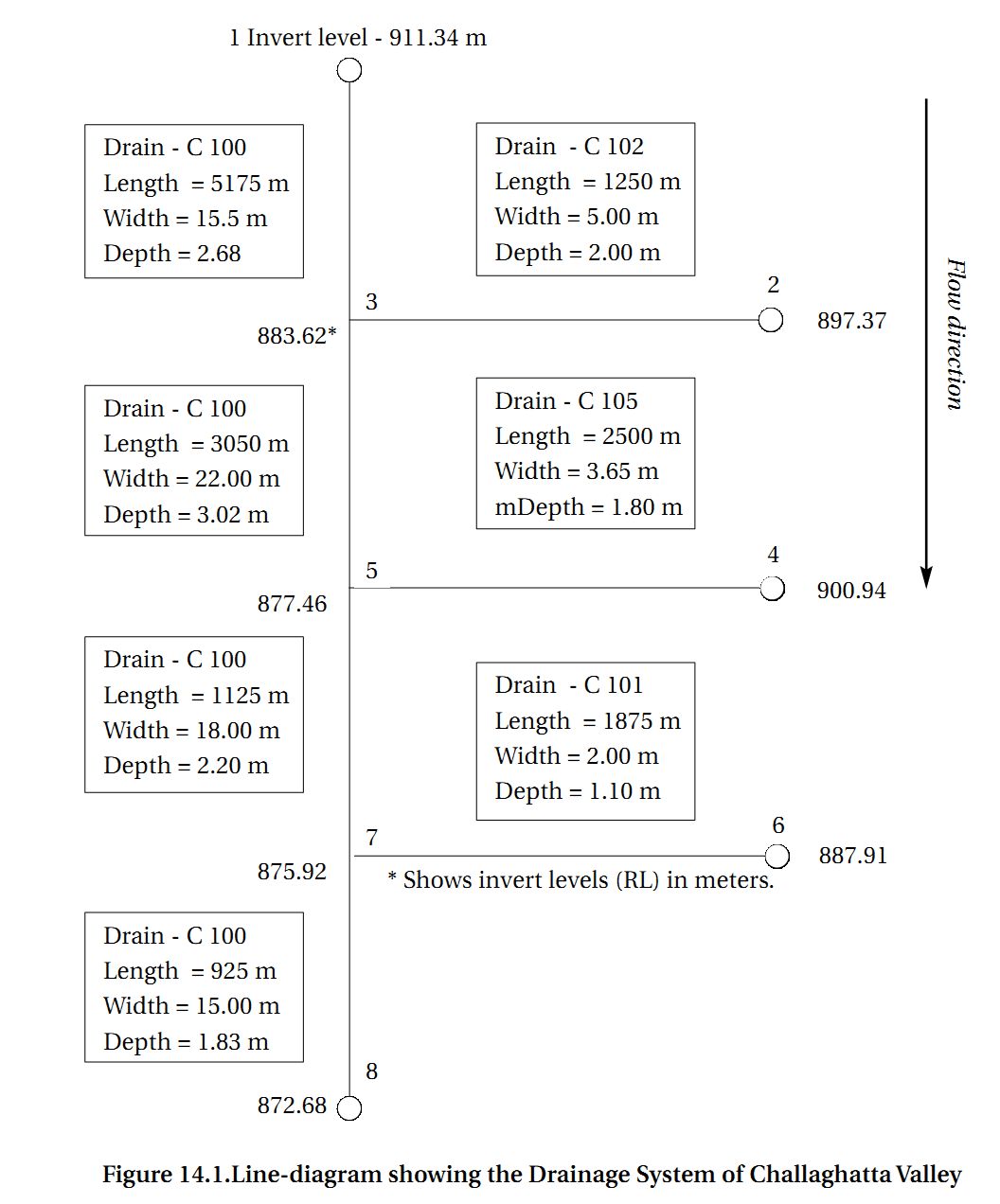
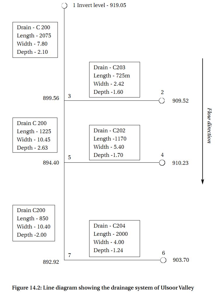
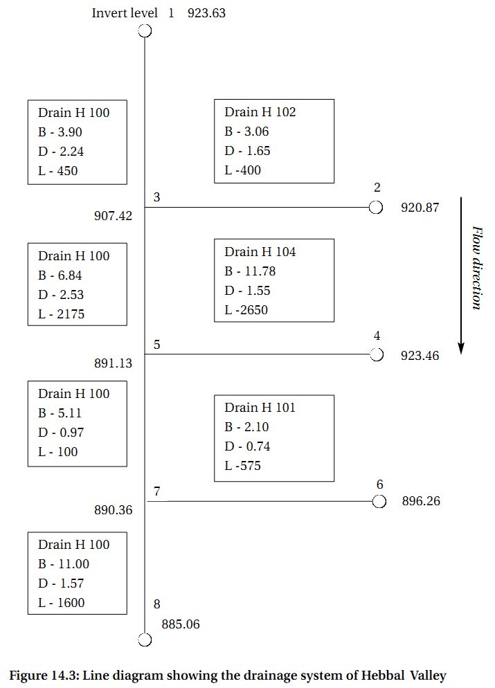
Reclamation of lakes for various developmental activities (Plate 4.1) has resulted in the loss of interconnectivity in Bangalore district leading to higher instances of floods even during the normal rainfall. Analyses of Bellandur and Ulsoor drainage network (figure 13.1) showed that the network is lost due to conversion of Chelgatta tank into a golf course. Similarly the drainage network between Madivala and Bellandur revealed of encroachment and conversion that has resulted in the loss of connectivity between Yelchenhalli kere and Madivala (figure 13.2). Figure 14.1, 14.2 and 14.3 provides the line diagrams of drainage systems of three valleys namely Challaghatta , Ulsoor Valley and Hebbal Valley.

Figure 13.1: Ulsoor–Bellandur–Varthur (a) drainage network (b) lakes overlaid on 10 m DEM showing their missing interconnectivity

Figure 13.2: Madivala–Bellandur–Varthur (a) drainage network (b) lakes overlaid on 10 m DEM showing their missing interconnectivity
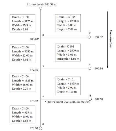
Figure 14.1. Line-diagram showing the Drainage System of Challaghatta Valley
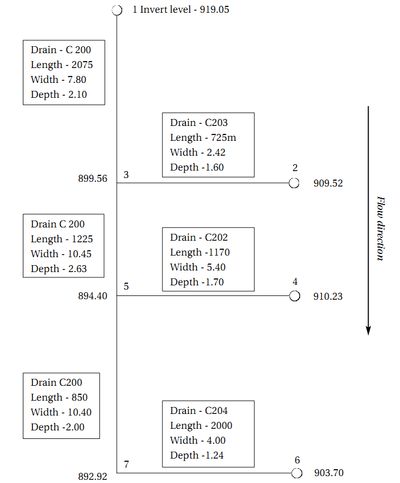
Figure 14.2: Line diagram showing the drainage system of Ulsoor Valley
Figure 14.3: Line diagram showing the drainage system of Hebbal Valley
Increased peak discharge and higher frequency of floods are the consequences of urbanisation. As land is converted from fields to built up, it loses its ability to absorb rainfall. Urbanisation has increased runoff 2 to 6 times over what would occur on natural terrain in some pockets of Bangalore. During periods of urban flooding, streets become swift moving rivers, while low lying residential areas and basements become death traps as they fill with water. Conversion of water bodies to residential layouts has further exaggerated the problem.
Flooding in urban areas causes large damage at buildings and other public and private infrastructure (evident during 1997, 2002 and 2007). Besides, street flooding can limit or completely hinder the functioning of traffic systems and has indirect consequences such as loss of business and opportunity. The expected total damage; direct and indirect monetary damage costs as well as possible social consequences is related to the physical properties of the flood, i.e. the water level above ground level, the extent of flooding in terms of water volume escaping from or not being entering the drainage system, and the duration of flooding.
Ulsoor–Belandur catchment: This catchment has 6 lakes – Sankey, Ulsoor, Chalghata, Chinnagara and Varthur and was classified into three major land use types – built up, vegetation and others (comprising open land, waste land etc). The total rainfall yield in this catchment is 240 Mm3, percolated water is 90 Mm3 and water overflow is 150 Mm3. The SRTM DEM data were resampled to 10 m resolution and the volume of each lake was computed assuming the depth to be 1 m and the mean annual rainfall to be 850 mm. The total volume of all the 6 lakes in this catchment is 73 Mm3. Hence there is surplus overland flow of 77 Mm3, which cannot flow to downstream due to disruption of natural drainage (removal of lakes and blockage of storm water drains) resulting in flooding (even during normal rainfall).
Madivala–Varthur catchment: Similar analysis was done for Madivala catchment which has 14 lakes – Venkatapura, Yellakunte, Bandepalya, Begur Doddakere, Madivala, Hulimavu, Marenahalli, Govindanaikana kere, Tank north of Doresanipalya, Gittigere and Vaddarpalya. The total rainfall yield is 247 Mm3, percolated water is 97 Mm3 and the remaining 150 Mm3 water flows as overland flow and storage in lakes. The total volumes of all the lakes considering 1 m depth is 110 Mm3 resulting in the excess of 40 Mm3 from the catchment leading to artificial floods. In addition to rainfall, Belandur-Varthur watershed receives untreated municipal sewage to the order of 500MLD.
Disappearance of waterbodies or sharp decline in the number of waterbodies in Bangalore is mainly due to intense urbanisation and urban sprawl. Many lakes were encroached for illegal buildings (54%). Field survey (during July-August 2007) shows that nearly 66 % of lakes are sewage fed, 14 % surrounded by slums and 72% showed loss of catchment area. Also, lake catchments were used as dumping yards for either municipal solid waste or building debris. The surrounding of these lakes have illegal constructions of buildings and most of the times, slum dwellers occupy the adjoining areas. At many sites, water is used for washing and household activities and even fishing was observed at one of these sites. Multi-storied buildings have come up on some lake beds that have totally intervened the natural catchment flow leading to sharp decline in the catchment yield and also deteriorating quality of waterbodies. Table 8.1 summarises the causal factors for poor drainage system and remedial measures to be undertaken to improve the condition.
Table 8.1: Causal factors and key impacts
| Causal factors |
Key Impacts and remedial actions |
| Unplanned urbanisation |
Increase of impervious surfaces and non-upgradation of drains to handle enhanced runoff
Encroachment of drains |
Causes increased volume and rate of surface run-off from developed lands, which leads to more flash flooding and increased extent, height and frequency of flooding.
- Prevention of alteration of topography in the catchment. Upgradation of drains from top of catchment to catchment outlet for handling increases in run-off
|
| Sediment and erosion from median strips and verges, spills from construction vehicles (e.g. concreting, earthmoving) |
Reduced capacity,
- Improved catchment management practices
|
| Development in flood-prone areas |
| Encroachment and alteration of floodplain |
Restricts flow and increases flooding on unfilled lands
- Control filling to overall valley
|
Reduces flood storage capacity, increasing downstream flooding
- Undertake whole of catchment planning for drainage
|
| Inadequate provision for main drains in development plans |
Causes gradual reduction in waterway capacity due to encroachments
- enforce compliance
- Incorporate drainage reserves
|
| Development below flood level |
Creates high flood damage, lowers standard of housing and reduces property values
- Prepare flood level plans to a datum and use them to control building floors and other development
|
| Cross drainage (and services in drains) |
| Lack of capacity of cross drainage works |
Causes localised and widespread flooding
- Reconstruct to a standard equal to the future drain requirements
|
| Construction of services (water, telecommunication, power etc.) above invert and below flood level |
Obstructs flow and aggravates flooding
- Relocate services, coordinate works and agree on service locations
|
| Sewerage system in drains |
| Reduction in stormwater system capacity |
Increases flooding significantly
- Lower manholes and reconstruct sewers below drain invert
|
| Obstruction and redistribution of stormwater flow, generally poorly constructed sections |
Causes bank and bed erosion; flooding in the waterways
- Reconstruct and improve future designs
|
| Solid waste disposal |
| Dumping of solid waste and building site waste in the drainage channel |
Causes blockage and pollution in the drainage system
- Implement solid waste strategy plan
|
| Unstable and degraded waterways |
| Weed infestation, encroachment, vegetation loss, and eroded and unstable riparian zones |
Causes siltation of downstream waterways
- Treat erosion sites and develop guidelines for silt control during construction
|
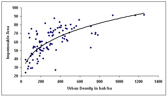
Landsat ETM+ data of 15 m spatial resolution (on fusing with Landsat ETM+ PAN) have been used to estimate impermeable areas that does not distinguish between types of urban land use (industrial, commercial and residential) but consist of a sample from a mixture of residential and commercial areas. Figure 15 shows the relation found between impermeable area to urban population density. Consequence of increase in built up pixels (evident from the increase in paved surface or impermeable area) is the increase of population density in a region.
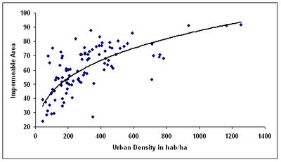
Figure 15: Impermeable area and urban density for Bangalore city
There is a general lack of appreciation of the potential values and importance of waterways in the urban environment and also fragmented management approaches have contributed to decline in waterways in the catchment. Although sewerage system is provided in many drainage basins in the core area by BWSSB, there are still large quantities of raw and partially treated sewage flowing in the urban drains and ultimately polluting the lakes. This is due to combination of wastes discharged from un-sewered premises, branch sewers not connected to the trunk sewers, and effluent from trunk sewers that are under capacity due to siltation or higher than planned development densities. Another significant factor contributing to frequent flooding of low-lying areas and to unsanitary conditions in drains and lakes is the large and rapid accumulation of sediments in the drains, dumping of solid wastes, building debris and casual litter disposal on drains. Similarly, erosion control practices in construction sites, public parklands, private gardens and on the medians and verges of roads are not sufficient to prevent large silt loads reaching the main drains. These factors, combined with infrequent clearance of drains, have lead to the unsanitary conditions in drains and to drains with much reduced capacity.
Also, due to increased paved surface and concentrated human activities the magnitude of the difference in observed ambient air temperature between urban pockets (artificial land surface) and the regions covered with vegetation (natural area), which is ascribed as urban heat island effect. The urban heat-island effect results in increased local atmospheric and surface temperatures in urban pockets compared to the surrounding open spaces, etc. Specifically, surface and atmospheric temperatures are increased by anthropogenic heat discharge due to energy consumption, increased land surface coverage by artificial materials having high heat capacities and conductivities, increased vehicular and industrial emissions and the associated decreases in vegetation and water pervious surfaces, which reduce surface temperature through evapotranspiration. An attempt is made here to understand the implications of land cover changes on local climate.
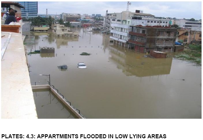
Inadequate drainage causes inconvenience and loss to the property and human life depending on the intensity (Plate 4.3). It leads to flooding of houses and establishments in the floodplains. In its least severe form, poor drainage causes water stagnation that provides a breeding ground for disease vectors.
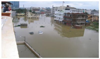
Plate 4.3: Flooding In Banashanakari (Photo: Ranjini)
Vulnerability of Communities with Poor Drainage
Socio-economic condition, age and gender decide the vulnerability. This is aggravated by type of dwelling as well as inadequate drainage in and around living areas. Many of the slums and informal settlements of poor communities are either located along the drainage lines or in low-lying areas (Plate 4.4). They build their houses using semi-permanent materials (such as earth, thatch and plastic sheets) that afford little protection from floods. These communities suffer extensive damage to their property in the event of even minor localised flooding and are also are vulnerable water logging from slow drainage of rainwater. Many of these settlements are illegal encroachments, the losses suffered by residents are never formally recognised or compensated. Vulnerability arising from the specific location of poor households is one of the key factors contributing to the inadequate living conditions of the poor in urban areas. Often plinths of houses in slums and informal settlements are lower than the road heights, which are raised over the years due to road development activities. Such areas require very good drainage, as even small quantities of stagnant water can flood the houses. Out of the 360 officially recognised slums in Bangalore only 30 percent have underground sewerage services. Hence, in the majority of slums wastewater must be discharged via the stormwater system, where one exists.
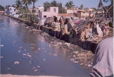
Plate 4.4: Encroachment of a drain by slums and disposal of solid and liquid waste


