|
 |
 |
|
| E Mail: cestvr@ces.iisc.ac.in , energy@ces.iisc.ac.in URL: http://ces.iisc.ac.in/energy , http://ces.iisc.ac.in/biodiversity | |||
| Synopsis Introduction Study Area Objectives Methodology Results and Discussion Acknowledgement Bibliography | Home PDF |
|
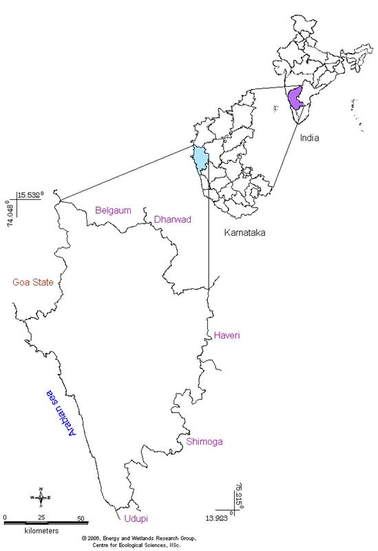
STUDY AREA: UTTARA KANNADA DISTRICT Uttara Kannada (North Canara) district lies between 13.9220o N to 15.5252o N latitude and 74.0852o E to 75.0999o E longitude (Figure 1) and covers an area of 10,291 km2. It extends from north south to a maximum of 180 km, and from west to east a maximum width of 110 km. The Arabian Sea borders it on the west creating a long continuous, though narrow, coastline of 120 km running north‑south. Goa‑Belgaum, Dharwad and Shimoga‑Dakshina Kannada form the northern, eastern and southern boundaries respectively. Uttara Kannada district is one of the northernmost districts in Karnataka State. The district comprises of 11 Taluks namely, Supa, Haliyal, Mundgod, Yellapur, Karwar, Ankola, Sirsi, Siddapur, Honnavar, Kumta and Bhatkal. Figure 1: Geographical location of Uttara Kannada District, Karnataka State, India Topographically, the district can be divided into 3 distinct zones namely narrow and flat coastal zone, abruptly rising ridge zone and elevated flatter eastern zone. The coastal zone is thickly populated with coconut clad villages. Ridge zone is a part of the main range of Western Ghats, which runs north to south, parallel to the coast. The flat eastern zone joins the Deccan plateau. The taluks, which comprises the narrow flat coastal zone, are: Karwar, Ankola, Kumta, Honnavar and Bhatkal.
Table 1: Geographic area, percentage forest cover and percentage change in population
The geographic area, area under forest, population density, and livestock density of each taluk of Uttara Kannada district is listed in Table 1. Supa is the largest taluk in Uttara Kannada in terms of area. It is seen that the highest populated taluk is Sirsi, whereas the percentage of population increase over a period of 40 years is maximum in Mundgod taluk. The forested area is largest in Yellapur followed by Supa taluk. The population according to 2001 census data was 1,353,644 which amount to a population density of 132.42 persons per sq km implying a growth of 10.9 % in population data of 1991. Table 2 lists talukwise population density that indicates Bhatkal taluk has maximum, while Supa taluk has minimum population density. Table 2: Taluk wise statistics of area, population, population density, number of villages and uninhabited villages.
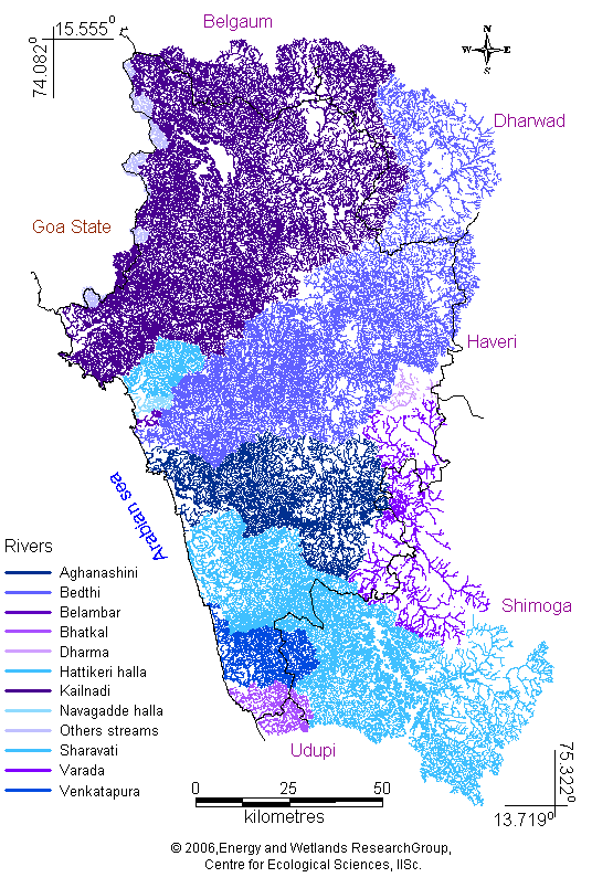
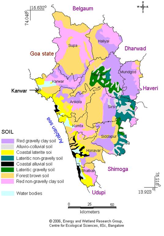
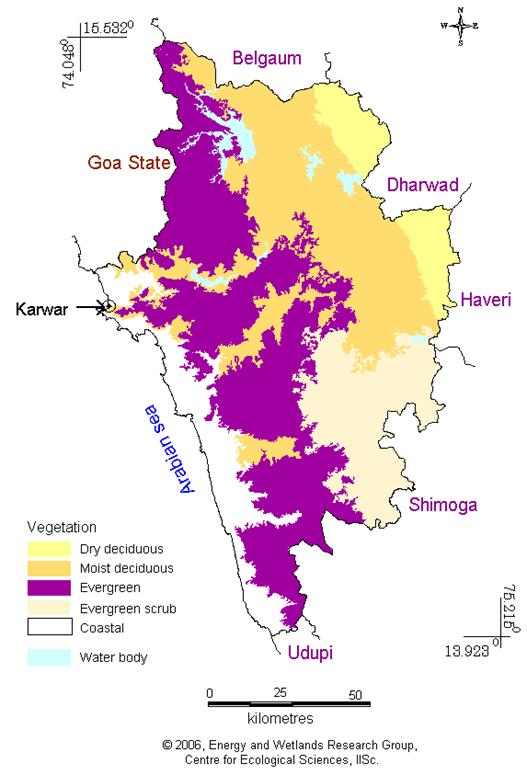
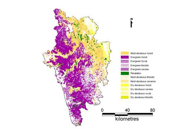
+ with out considering the population of taluk head quarters. * population distribution maps for each taluk is given at the end. Five major rivers of Uttara Kannada, namely, Bedthi (Bedti / Gangavalli), Aganashini (Tadri), Varda, Sharavathi and Kali, illustrated in Figure 2, form the major sources of drainage system in Uttara Kannada. These rivers flow from west through the district into the Arabian Sea. Most of the streams in the hilly tract have a long length of flow. Some of the most spectacular waterfalls of the country such as Jog Falls, Unchalli Falls, and Magod Falls are found in Uttara Kannada. The point where the rivers meet the sea, some of the finest estuaries are present. SOILS: The soil can be described as derivatives of the most ancient metamorphic rocks in India, which are rich in iron and manganese (Pascal, 1988). The soils of the district are basically divided into two distinct zones based on topography; the coastal alluvial soil and the upghat lateritic and granitic soils. Mixed lateritic soils are found in taluks of Supa, Haliyal and Mundgod, which contains certain patches of black soil as well. The lateritic soils are highly leached, reddish brown in colour, shallow to medium in depth and loamy in texture. These soils are found in the taluks of Karwar, Kumta, Honnavar, Bhatkal, Sirsi and Siddapur (Figure 3). Figure 2: Rivers with drainage network in Uttara Kannada district Figure 3: Soil of Uttara Kannada VEGETATION: The Western Ghats of Uttara Kannada district is known for their dense forests which cover about 80% of the area of the district. The total forest of Uttara Kannada is about 8,29,151 ha., and the per capita forest is about 0.77 ha. The forests of Uttara Kannada can be classified into 3 categories based on density (Akbar Sha, 1988) as Partially open forest ( 20‑40% density), Medium density forest (40‑80% density) and Closed forest(above 80% density). Based on this classification Uttara Kannada district has about 1388.89 km2 of partially open forest, 1646.16 km2 of medium density forest and 714.55 km2 of closed forest. Depending on phenological conditions and other ecological factors, the forests of Uttara Kannada are broadly divided into two types namely Moist and Dry types. The moist type may be sub‑divided into evergreen, semi‑evergreen and moist deciduous. The dry type can be divided into dry deciduous and thorny forest The central part of Uttara Kannada is of the evergreen type as shown in Figure 4. They are composed of very tall trees, forming a very dense canopy and are many storied and impenetrable. The rainfall in this forest is as high as 4000‑5000 mm. The semi‑evergreen forests are seen in pockets and often merges with the evergreen and the moist deciduous type. Therefore distinguishing them is rather difficult. In the moist deciduous forest, tree species remain deciduous only for a short time. These forests have semi‑evergreen species in the upper canopy and evergreen in the lower storey. In these forests, some moist places have predominance of bamboo and on red soil Xylia is present. They have a rainfall of about 1000‑2000 mm.
Figure 4: Vegetation distribution for Uttara Kannada District. Uttara Kannada vegetation is divided into 5 broad zones by Daniels et.al.(1989) namely, Coastal zone, Northern evergreen zone, Southern evergreen zone, Moist deciduous zone and Dry deciduous zone. Uttara Kannada has 21 habitat types according to Daniels (1989), based on a study in 181, 5x5 km grids. They are, Evergreen forests (65%), Rocky cliffs (14%), Degraded evergreen thickets (17%), Moist grasslands (9%), Moist/dry teak (29%), Humid betelnut (50%), Freshwater marshes (25%), Exotic tree plantations (25%), Rivers (10%), Hillstreams (55%), Coastline (9%), Beaches (6%), Coastal coconut (9%), Estuaries (5%), Scrub (2%), Dry deciduous forest (5%), Moist/Dry Bamboo facies (6%), Moist/Dry cultivation (31%), Moist/Dry Eucalyptus (10%), Moist Deciduous forests (18%), Urban population > 1000 (22%). The major vegetation types of Uttara Kannada have been broadly grouped as
According to Pascal’s Forest Map of South India (Figure 5) the vegetation is classified as follows: Group I. Evergreen or semi-evergreen climax and potentially related forests I. Evergreen or semi-evergreen climax and potentially related forests.
Dipterocarpus indicus-Diospyros candolleana-Diospyros oocarpa type: Honnavar and Kumta (Scanty distribution only)
Transition type: Joida Figure 5: Vegetation distribution for Uttara Kannada District
Disturbed low elevation: all taluks except Haliyal and Mundgod
Dense forest: Joida, Yellapur, and Sirsi.
Thicket low elevation: all except Haliyal and Mundgod. Group II. Deciduous climax forests and degradation
|
||||||||||||||||||||||||||||||||||||||||||||||||||||||||||||||||||||||||||||||||||||||||||||||||||||||||||||||||||||||||||||||||||||||||||||||||||||||||||||||||

| E-mail | Sahyadri | ENVIS | Energy | GRASS | CES | IISc | E-mail |