|
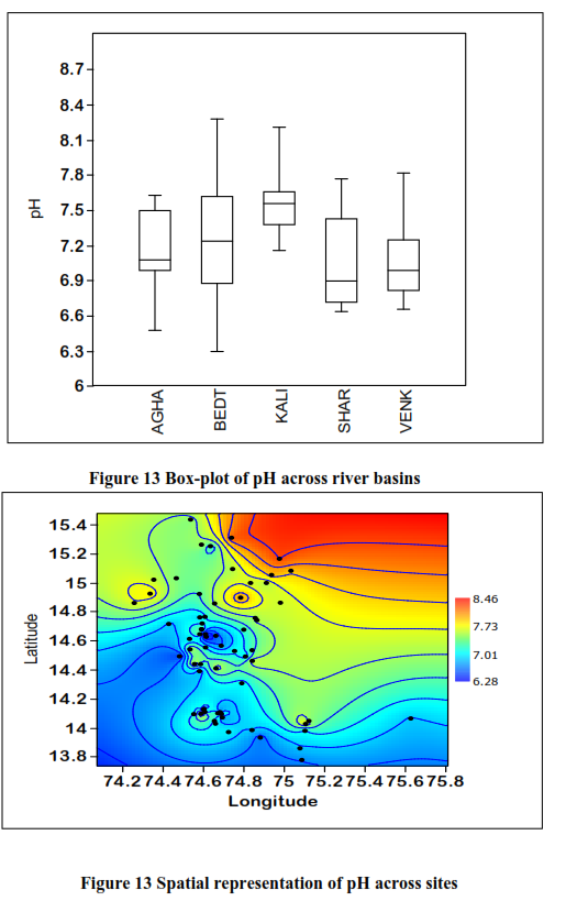
The pH of river water is the measure of how acidic or basic the water is on a scale of 0-14. It is a measure of hydrogen ion concentration. Most of the peninsular rivers falls between 6.5 and 8.5 on this scale with 7.0 being neutral. The optimum pH for river water is around 7.4. Water's pH can be altered by industrial and agricultural runoff. Vajgadde at BRB has recorded low pH of 6.9 and Kalghatghi from the same river basic has recorded highest pH of 8.27. In the current study the low range of pH observed in forested streams and high alkaline pH observed in sites contaminated with agricultural and urban runoff (figure 12 and 13). A pH of 8.0 should be sufficient to support most river life with the possible exception of snails, clams, and mussels, which usually prefer a slightly higher pH. The average pH in the study was 6.9, a value that is only sufficiently basic for bacteria, carp, suckers, catfish, and insects. BRB and KRB records most of the alkaline sites, where as ARB, SRB and VRB sites records neutral to near acidic sites.

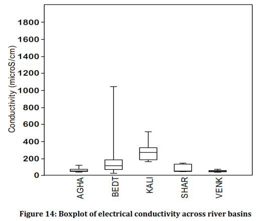
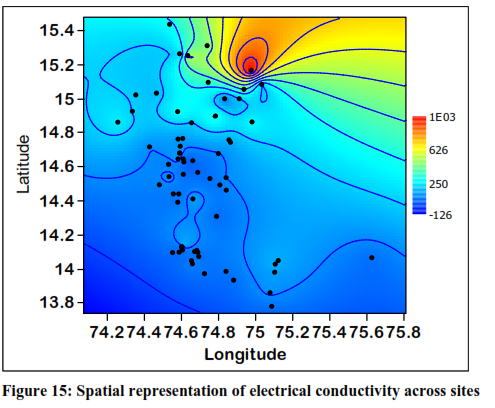
Electrical Conductivity and Total Dissolved Solids: Conductivity is a measure of the ability of water to pass an electrical current. Conductivity in water is affected by the presence of inorganic dissolved solids such as chloride, nitrate, sulfate, and phosphate anions (ions that carry a negative charge) or sodium, magnesium, calcium, iron, and aluminum cat ions (ions that carry a positive charge). Organic compounds like oil, phenol, alcohol, and sugar do not conduct electrical current very well and therefore have a low conductivity when in water. Conductivity is also affected by temperature: the warmer the water, the higher the conductivity. Low level of electrical conductivity is observed at Vajgadde at BRB (22.5 µS/cm) and highest value was recorded from Kalghatghi of the BRB (1038.95 µS/cm), as illustrated in Figure 14. Sites of BRB showed high levels of variation when compared to the SRB and VRB. KRB sites recorded comparatively high levels of conductivity and total dissolved solids due to sedimentation from the monoculture plantations of its catchment area in the north part of the river basin (Figure 15).

Discharges to streams can change the conductivity depending on their make-up. A failing sewage system would raise the conductivity because of the presence of chloride, phosphate, and nitrate; an oil spill would lower the conductivity.

Dissolved Oxygen: An adequate supply of dissolved oxygen gas is essential for the survival of aquatic organisms. A deficiency in this area is a sign of an unhealthy river. There are a variety of factors affecting levels of dissolved oxygen. The atmosphere is a major source of dissolved oxygen in river water. Waves and tumbling water mix atmospheric oxygen with river water. Oxygen is also produced by rooted aquatic plants and algae as a product of photosynthesis.
In the present study lowest dissolved oxygen levels were observed in Kervada (3.67 mg/L) from KRB. This site is located next to the point where the Paper mills effluent confluence with the main river. The paper mill effluent is characterized with high levels of organic content, which consumes most of the oxygen for its degradation with help of the bacteria. Bacteria which decompose plant material and animal waste consume dissolved oxygen, thus decreasing the quantity available to support life. Ironically, it is life in the form of plants and algae that grow uncontrolled due to fertilizer that leads to the masses of decaying plant matter. This site is also infested with marsh crocodiles (Crocodylus palustris), which prevails as a major threat to the humans and cattle in the surrounding s. Crocodiles are attracted to this particular place due to availability of the solid organic contents present the paper mill effluent. Sites at SRB recorded saturated levels of dissolved oxygen in the streams and all other sites recorded with high variation. Apart from the organic pollution other reason for low levels of dissolved oxygen is lack of mixing in water. In most of the middle reaches of all the rivers water is stopped by the small to moderate levels of check dams for agricultural activities. Stagnated water lack gas mixing, which lead to low levels of dissolved oxygen.

Unlike temperature and dissolved oxygen, the presence of nitrates usually does not have a direct effect on aquatic insects or fish. However, excess levels of nitrates in water can create conditions that make it difficult for aquatic insects or fish to survive. Nitrate-nitrogen is important because it is biologically available and is the most abundant form of nitrogen in Central Western Ghats streams. Like phosphorus, nitrate can stimulate excessive and undesirable levels of algal growth in water bodies. Nitrates come to the streams mainly from the runoff from the agriculture farms and sedimentation. Runoff from the agriculture farms carries huge amount of fertilizer residues. Among the study river basins, KRB and BRB recorded high levels of nitrates from its upstream region. Both KRB and BRB possess intense agriculture and limited water area in its upstream regions which leads to high levels of nitrates.
Figure 17: Boxplot showing the Nitrate valve across river basins
Along with the nitrates, phosphates also play a important role in the river hydrobiology. Phosphorus is an important nutrient for plant growth. Total phosphorus is the measure of the total concentration of phosphorus present in a water sample. Excess phosphorus in the river is a concern because it can stimulate the growth of algae. Excessive algae growth, death, and decay can severely deplete the oxygen supply in the river, endangering fish and other forms of aquatic life. Urban runoff is the major source for phosphates in the streams. In the current study regions, BRB receives considerable amount of urban sewage from Hubli city. The impact of high levels of phosphates leads to algal blooms in many reaches of the Bedthi River. Manchikeri site located in between Sirsi and Yellapur have a check dam for pumping water for drinking water supply. Recently a check dam was constructed near the Manchikeri Bridge for storing water for Yellapur drinking water supply. Check dam paves a way to stores the severely polluted water and reduces the dilution of pollution. Stagnated water with heavy nutrient content leads to algal bloom. Preliminary investigations suggest that the algal bloom was created by algal genus Microcystis. Microcystis is a type of blue-green algae (also referred to as Cyanobacteria). This genus is colonial, which means that single cells can join together in groups which tend to float on the water surface. Colony sizes will vary from a few to hundreds of cells. It is a common bloom-forming algae found primarily in nutrient enriched river and lake waters. Any large algal bloom has the potential to result in fish kills by depleting the water of oxygen. The dead algal cells sink down and consume huge amount of oxygen for their decomposition. In such situations, there may not be enough oxygen remaining in the water to support fish in the vicinity. Furthermore, as these large blooms die and sink to the bottom, they commonly release chemicals that can produce a foul odor and musty taste. Some strains of Microcystis may produce toxins that have been reported to result in health problems to animals that drink the water, and minor skin irritation and gastrointestinal discomfort in humans that come in contact with toxic blooms. Uncontrolled growth of single species of algae will also lead to death of aquatic invertebrates and fishes due to unavailability of food, which in turn affects the aquatic food chain.
|
Dr. T.V. Ramachandra
Centre for Sustainable Technologies, Centre for infrastructure, Sustainable Transportation and Urban Planning (CiSTUP), Energy & Wetlands Research Group, Centre for Ecological Sciences, Indian Institute of Science, Bangalore – 560 012, INDIA.
E-mail : cestvr@ces.iisc.ac.in
Tel: 91-080-22933099/23600985,
Fax: 91-080-23601428/23600085
Web: http://ces.iisc.ac.in/energy
Subash Chandran M.DEnergy & Wetlands Research Group, Centre for Ecological Sciences, Indian Institute of Science, Bangalore – 560 012, INDIA.
E-mail: mds@ces.iisc.ac.in
Joshi N.V.Energy & Wetlands Research Group, Centre for Ecological Sciences, Indian Institute of Science, Bangalore – 560 012, INDIA.
E-mail: nvjoshi@ces.iisc.ac.in
Karthick B.
Energy & Wetlands Research Group, Centre for Ecological Sciences, Indian Institute of Science, Bangalore – 560 012, INDIA.
Sameer Ali
Energy & Wetlands Research Group, Centre for Ecological Sciences, Indian Institute of Science, Bangalore – 560 012, INDIA.
Vishnu D. Mukri
Energy & Wetlands Research Group, Centre for Ecological Sciences, Indian Institute of Science, Bangalore – 560 012, INDIA.
Citation:Ramachandra T.V., Subash Chandran M.D., Joshi N.V., Karthick B., Sameer Ali, Vishnu D. Mukri, 2012. Ecohydrology of Lotic Ecosystems of Uttara Kannada, Central Western Ghats , ENVIS Technical Report 40, Energy & Wetlands Research Group, CES, IISc, Bangalore, India.
| Contact Address : |
| |
Dr. T.V. Ramachandra
Energy & Wetlands Research Group,
Centre for Ecological Sciences, TE 15, New Biology Building, Third Floor, E Wing, [Near D Gate], Indian Institute of Science, Bangalore – 560 012, INDIA.
Tel : 91-80-22933099 / 22933503-extn 107
Fax : 91-80-23601428 / 23600085 / 23600683 [CES-TVR]
E-mail : cestvr@ces.iisc.ac.in, energy@ces.iisc.ac.in,
Web : http://wgbis.ces.iisc.ac.in/energy |
|