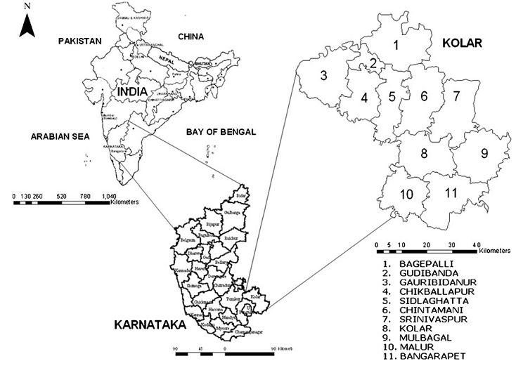
Data and Study Area The MOD 09 Surface Reflectance 8-day (19-26th Dec 02) L3G product at 250 m (band 1 and 2) and bands 3 to 7 at 500 m spatial resolution (http://edcimswww.cr.usgs.gov/pub/imswelcome/), and MOD 02 Level-1B Calibrated Geolocation (georeferenced) data at 1 km (bands 1 to 36, acquired on 21st Dec 02 described at http://modis.gsfc.nasa.gov/data/dataprod/) were used. They are atmospherically and radiometrically corrected, fully calibrated and geolocated radiances at-aperture for all spectral bands and are processed to Level 3G (http://modis.gsfc.nasa.gov/data/dataprod/dataproducts.php?MOD_ NUMBER =09) and Level 1B (http://daac.gsfc.nasa.gov/MODIS/Aqua/ product_descriptions_modis.s html#rad_geo) respectively. IRS (Indian Remote Sensing Satellite) LISS (Linear Imaging Self Scanner)-III MSS data in Green, Red and NIR bands with a spatial resolution of 23.5 m (acquired on 22nd and 25th Dec 02) were purchased from National Remote Sensing Agency, Hyderabad, India. The Kolar district in Karnataka State, India, extending over an area of 8,238 km2 between 77°21’ to 78°21 E and 12°46’ to 13°58’ N, was chosen for this study. Kolar (figure 1) is divided into 11 sub-regions for administration purposes (Ramachandra and Rao, 2005). The study area is mainly dominated by 6 broad LC classes: agricultural land, built up, forest, plantations, waste land and water bodies. There are a few other LC classes (barren/rock/stone/others) that have very limited ground area proportions and are unevenly scattered among the major six classes, and were grouped under the waste land category.
Citation: Uttam Kumar, Norman Kerle, Milap Punia and T. V. Ramachandra , 2011, Mining Land Cover Information Using Multilayer. J Indian Soc Remote Sens,
DOI 10.1007/s12524-011-0061-y.
|