INTRODUCTION
The Earth consists of atmosphere, hydrosphere, and lithosphere. These layers are subject to different processes due to mutual interaction or self-interaction. Interactions can lead to various phenomenon, weathering, erosion, floods, hurricanes, landslides, earth quakes, volcanoes, tectonic movements, etc., which can lead to natural hazard. Natural hazards are an integral component of life on Earth. Natural disasters are grouped as:
- Hydro-meteorological disasters: avalanches/landslides, droughts/famines, extreme temperatures, floods, forest/scrub fires, windstorms and other disasters, such as insect infestations and wave surges
- Geophysical disasters: earthquakes, tsunamis and volcanic eruptions.
The number of recorded natural hazards has increased in the last 50 years with the greatest increase in frequency attributed to hydro-meteorological disasters, with a lesser increase attributed to biological disasters and a slightly lesser increase attributed to geological disasters. The pressure for infrastructure development to meet the need of rapid urbanisation and global competition has led to expansion of construction activities even in hilly terrains and has catapulted frequency of landslides to dramatic proportions in recent decades. Landslide refers to the movement of a mass of rock, debris, or earth down a slope or any down slope movement of soil and rock under the direct influence of gravity. This includes various types of slope failures, like, earth and debris flows, slumps, slides, and soil and rock fall. Landslide is a phenomenon of a mass movement of landform and which is characterized by moderately rapid to rapid (> 30 cm per year) down-slope transport, by means of gravitational stresses, of a mass of rock and regolith that may or may not be water saturated. Landslides are one of the normal landscape building processes in undulating terrain and are common in Himalayas and Western Ghats regions in India. It includes any detached mass of soil, rock, or debris that moves down a slope or a stream channel. They are classified according to the type and rate of movement and the type of materials that are transported. Two types of forces are at work:
- driving forces combine to cause a slope to move, and
- friction forces and strength of materials act to stabilise the slope.
When driving forces exceed resisting forces, landslides occur. It is one of the common natural hazards with devastating effects. They become a problem when they interfere with human activity resulting in damage to property and loss of life, evident from recent episodes in Ooty (Tamil Nadu) and Kerala. In order to minimise the losses due to landslide, it is necessary to identify and analyse the most important determining factors leading to slope failures. They occur as “on-site” hazards and “off-site” hazards, and should be distinguished to effectively plan for future hazard situations.
- On-site hazards occur on or near the development site and are typically the slower moving landslides that cause most of the property damage in urban areas. They include features called slumps, earth flows and block slides.
- Off-site hazards typically begin on steep slopes at a distance from homes or developments, and are often rapidly moving.
Landslide occurs when force that is pulling the slope downward exceeds the shear strength of the earth materials that compose the slope or when sliding factor (Fs) <1
Fs=Ff / Fd Where, Ff= frictional force
Ff=μ N Fd= driving force
N= mg.cos(θ) µ= coefficient of friction
Fd= mg.sin(θ) N= normal component
When dams are constructed along a river's course they drastically change the river's hydrology, causing severe impacts on its ecosystems (up and downstream of the dam). One of the most significant immediate impacts is the drastic change that can occur in the groundwater table. In the case of the Sharavathi River Basin, the Linganamakki reservoir submerged 375 km2 of land increasing the water table level by over 40 m to designate a new shoreline. In response to this action, anthropogenic activity, including the creation of roads, houses and development had to be pushed higher up the valleys into the terrain of higher elevation than had previously been used. The purpose of this study is to see the parameters that are likely to have a decisive role in the slope failures. Figure 1.1 depicts a typical landslide that has occurred in the Sharavathi river basin due to slope failure.
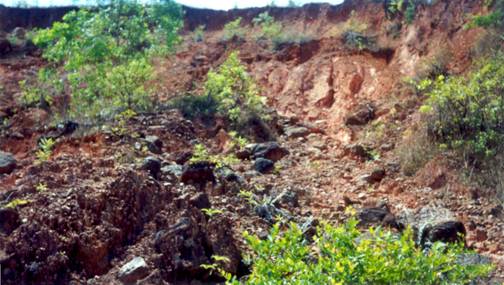
Figure 1.1: A view of a landslide in the study area
1. Different Types of Landslides
Landslides are classified and described on the basis material and types of movement (Varnes, 1978) are listed in Table 1. Materials wise classification is on based on the size of predominant material present in the slide i.e., is it rock, debris and earth. The movement based classification is divided into six types as falls, topples, slide, spread, flow, complex. These types of landslides are resultant of the temporal conjunction of several factors.
Landslides are classified by causal factors and conditions, and include falls, slides and flows, which are described below. There are many attributes used as criteria for identification and classification including rate of movement, type of material and nature of movement. A combination of characteristics can also contribute to an increased risk of landslide hazards.
- Falls: Falls are abrupt movements of rocks and boulders i.e., masses of geologic materials that become detached from steep slopes or cliffs. Movement occurs by free-fall, bouncing, and rolling on separation along discontinuities such as fractures, joints, and bedding planes. Gravity, mechanical weathering, and the presence of interstitial water strongly influence falls.In falls, material is detached from a steep slope or cliff and descends through the air by free fall or by bouncing or rolling down the slope. Rock fall, the most common type, is a fall of detached rocks from an area of intact bedrock.
- Topples: The end-over-end motion of rock down a slope. Under the actions of gravity and forces exerted by adjacent units or by fluids in cracks toppling occurs. Toppling failures are distinguished by the forward rotation of a unit or units about some pivotal point, below or low in the unit.
- Slides: Even though the term slide used in general for any landslide it has more restrictive use of the term refers only to mass movements, where there is a distinct zone of weakness that separates the slide material from more stable underlying material. Slides include rockslides – the down slope movement of a rock mass along a plane surface; and slumps – the sliding of material along a curved (rotational slide) or flat (translational slide) surface. Slow-moving landslides can occur on relatively gentle slopes, and can cause significant property damage, but they are far less likely to result in serious human casualties.
- Flows: Flows are plastic or liquid movements in which mass (e.g., soil and rock) breaks up and flows during movement. Flows are typically rapidly moving and also tend to increase in volume as they scour out the channel.
- Debris flow: A debris flow is a form of rapid mass movement in which a combination of loose soil, rock, organic matter, air, and water mobilize as a slurry that flows downslope. Debris flows include <50% fines. Debris flows are commonly caused by intense surface-water flow, due to heavy precipitation or rapid snowmelt that erodes and mobilizes loose soil or rock on steep slopes. Debris flows also commonly mobilize from other types of landslides that occur on steep slopes, are nearly saturated, and consist of a large proportion of silt- and sand-sized material. Debris-flow source areas are often associated with steep gullies, and debris-flow deposits are usually indicated by the presence of debris fans at the mouths of gullies. Fires that denude slopes of vegetation intensify the susceptibility of slopes to debris flows.
- Earth flow: Earthflows have a characteristic "hourglass" shape. The slope material liquefies and runs out, forming a bowl or depression at the head. The flow itself is elongate and usually occurs in fine-grained materials or clay-bearing rocks on moderate slopes and under saturated conditions. However, dry flows of granular material are also possible.
- Mud flow: A mudflow is an earthflow consisting of material that is wet enough to flow rapidly and that contains at least 50 percent sand-, silt-, and clay-sized particles. In some instances, for example in many newspaper reports, mudflows and debris flows are commonly referred to as "mudslides."
- Creep: Creep is the unnoticeably slow, steady, downward movement of slope-forming soil or rock. Movement is caused by shear stress sufficient to produce permanent deformation, but too small to produce shear failure. There are generally three types of creep: (1) seasonal, where movement is within the depth of soil affected by seasonal changes in soil moisture and soil temperature; (2) continuous, where shear stress continuously exceeds the strength of the material; and (3) progressive, where slopes are reaching the point of failure as other types of mass movements. Creep is indicated by curved tree trunks, bent fences or retaining walls, tilted poles or fences, and small soil ripples or ridges.
- Lateral spread: Lateral spreads are distinctive from other slides. They usually occur on very gentle slopes or flat terrain. The dominant mode of movement is lateral extension accompanied by shear or tensile fractures. The failure is caused by liquefaction, the process whereby saturated, loose, cohesionless sediments (usually sands and silts) are transformed from a solid into a liquefied state. Failure is usually triggered by rapid ground motion, such as that experienced during an earthquake, but can also be artificially induced due to human activity like mining, or even micro seismic waves from construction activities and vehicular movement. When coherent material, either bedrock or soil, rests on materials that liquefy, the upper units may undergo fracturing and extension and may then subside, translate, rotate, disintegrate, or liquefy and flow. Lateral spreading in fine-grained materials on shallow slopes is usually progressive. The failure starts suddenly in a small area and spreads rapidly. Often the initial failure is a slide, but in some materials movement occurs for no apparent reason. Combination of two or more of the above types is known as a complex landslide.
Slides due to cut-and-fill failures during roadway and building excavations, river bluff failures, lateral spreading landslides, collapse of mine-waste piles (especially coal), and in wide variety of slope failures are associated and open-pit mines or quarries in low-relief areas. It might be a slide in hilly terrain or in a low relief area landslides are resultant of the temporal conjunction of several factors or variables
Table 1: Types of landslides. Abbreviated version of Varnes' classification of slope movements (Varnes, 1978).
| Type of Movement |
Type of Material |
| Bedrock |
Engineering Soils |
| Predominantly Coarse |
Predominantly Fine |
| |
FALLS |
Rock fall |
Debris fall |
Earth fall |
| TOPPLES |
Rock topple |
Debris slide |
Earth slide |
| SLIDES |
ROTATIONAL |
Rock slide |
Debris slide |
Earth slide |
| TRANSLATIONAL |
| |
LATERAL SPREADS |
Rock spread |
Debris spread |
Earth spread |
| FLOWS |
Rock flow
(deep creep) |
Debris flow |
Earth flow |
| (soil creep) |
| COMPLEX |
Combination of two or more principal types of movement |
2. Causes of Landslides
Causes of landslides can be broadly distinguished as intrinsic and extrinsic factor, where the probability of landslide occurrence depends on both the intrinsic and extrinsic variables.
- Internal factors or Intrinsic variables: Geology, slope gradient; slope aspect, elevation, soil geotechnical properties, vegetation cover, and long-term drainage patterns are intrinsic variables that contribute to landslide susceptibility. The steeping of the slope, water content of the stratum and mineralogical composition and structural features, which tend to reduce the shearing strength of the rocks, are also vital factors for causing landslides.
- External factors or Extrinsic variables: A slight vibration or jerk to the mass would greatly add up against the frictional resistance and the mass would become unstable. The heavy traffic in a hilly terrain could be a contributing factor towards causing the imbalance of masses. The extrinsic variables may change over a very short time span, and are thus very difficult to estimate. If extrinsic variables are not taken into account, the term susceptibility could be employed to define the likelihood of occurrence of a landslide event. Variables which determine the probability of landslide for a particular slope or an area (Dai et al., 2002; 2001) may be grouped into two categories:
- Triggering variables or dynamic variables or extrinsic properties like heavy rainfall, glacier outburst, seismic activity, etc which often caused slope movements i.e., they shift the slope from a marginally stable to an unstable state and thereby initiating failure in an area of given susceptibility
- Preparatory variables or quasi static variables or intrinsic properties, which make the slope inherently susceptible to failure due to many existent concomitant properties which make the slope susceptible to failure without triggering it, such as geology, slope gradient, and aspect, elevation, soil, vegetation cover and long-term drainage patterns and weathering; and (Wu and Sidle, 1995, Atkinson and Massari, 1998).
Hydrology: The water in the region plays an important role as can be seen from classification of landslides. Heavy rainfall is a critical factor in triggering landslides because it generates rapid increases in pore pressure in the vadose zone and groundwater flow in the saturated area (Jiu J. Jiao, 2005).The percolating water through soil and sandstone wet the clay layer adding to the weight that reduces the slope strength. In addition to this water swells the clay and also decreases friction between grains, contributing to a loss cohesion intern decreasing resistance to landslide.
Geology: Geology comprised of structure and lithology. Lithology also influences landslide occurrences. Lithology, conditions both the shear strength of the rock mass and the permeability, and, consequently the possibility of there being increase in the increase pressure in the subsoil (L. Donati, and M.C. Turrini, 2002). Landslide occurs in loose and poorly consolidated slope material than in bedrock. The erodibility or the response to rocks to the process of weathering and erosion are the cause for formation of regolith. The rocks like quartz, limestone and igneous are generally hard, and resistant to erosion, forming steep slopes. In comparison, sedimentary rocks are vulnerable to erosion and form more easily landslide. Phyllites and schists are characterized by flaky minerals which weather quickly and promote instability (Giacomo D’Amato Avanzi et al, 2004). A sequence of strata having thin, soft and weak beds lying in between hard and thick beds provide a congenial set-up for landslide occurrence (Terzaghi and Peck, 1967). The instability is shown by joints, folds and faults or generally by lineaments which are the expressions of earths moulding and remoulding process. The presences of folds with anticline, with flanks mainly dipping towards the slope free face are more prone for landslide. The presence of lineaments is highly correlated with lithology (Pachauri et al, 1992; Atkinson et al, 1998A sequence of strata having thin, soft and weak beds lying in between hard and thick beds provide a congenial set-up for landslide occurrence (Terzaghi and Peck, 1967).
Structure: The structural weakness like inclined lineaments, bedding planes, joints, faults or shear zones increase the chance of landslide occurrence. Lineaments are defined as “mappable simple or composite linear features of a surface, whose parts are aligned in rectilinear or slightly curvilinear relationship and which differ distinctly from the patterns of adjacent features and presumably reflects a sub surface phenomenon” (O’Leary et al., 1976). Investigations have shown that the probability of landslide occurrence is notably increased at those sites closer to lineaments (Greenbaum et al., 1995). When the dip coincides with that of the surface slope they create conditions of instability (Kesavulu, 1997). Faults and joints provide scope for easy percolation of rainwater enhancing the instability.
Topography: Slope angle is another cause for landslides. Slope angle is formed between any part of surface of the earth and the horizontal datum. It is a means by which gravity induces stress in the slope rocks, flux of the water or other material; therefore, it is of great significance in hydrology and geomorphology. As the slope angle increases, then the shear stress in the soil or other unconsolidated material generally increases. Not only stress on the rock increases but slopes even affect the velocity of both surface and subsurface flow and hence soil water content, soil formation, erosion potential and other important geomorphic process. Places where the slope angle is near to 00 are considered to be safer in terms of failure initiation (Gomez H and Kavzogul T, 2005). Gentle slopes are expected to have a low frequency of landslides because of the generally lower shear stresses associated with low gradients. Steep natural slopes resulting from outcropping bedrock, however, may not be susceptible to shallow landslides (Saro Lee and Touch Sambath). Slope failure tends to increase with slope angle but when the slope becomes near the vertical, landsliding is scare or absent altogether as there is lack of soil development and debris accumulation in such topographic conditions (Selby, 1993; Derruau, 1983). But under such circumstance the rock fall increases. Still it noticed that frequency of landslide is more on steeper slope (McDermid and Franklin, 1995; Cooke and Doornkamp, 1990). Apart from the slope aspect and curvature also play an important role. The curvature is a morphological measure of the topography. A positive curvature indicates that the surface is upwardly convex at that cell, and a negative curvature indicates that the surface is upwardly concave at that cell. A value of zero indicates that the surface is flat.
Soil: The one of the most sensitive parameters is soil thickness (Van Westen et.al, 2006). Page et al. (1994) correlate sediment thickness with landslide events. Landslide is triggered as a decrease in shear strength of the soil due to an increase in pore-water pressure on the failure surface. An increase in pore-water pressure can be caused directly by percolating rainfall or indirectly by an accumulation of water at a certain depth due to changes in permeability within the soil cover (perched water tables) or by an accumulation of water at the soil-bedrock contact (Terlien, 1998). In soils, pore water pressures may be due to: (i) the hydrostatic head, (ii) pressures exerted by water flowing through a soil mass whose volume remains constant, and (iii) pressures associated with stress changes in the soil, which initiate changes in volume of the soil mass (consolidation or swelling) (Parcher, 1968). The pore water pressure build-up, prior to failure, accelerating the volume decrease of the soil, with water expelled from the voids contributing to an increase in pore pressure. An immediate consequence of the volume decrease during the pre-failure stage could be a debrisflow mobilization (Se´rgio et al, 2006). Several pore water pressure measurement conducted in the field have recorded that pore water pressure drops due to crack development or preferential pathway formation (Harp et al., 1990).
In addition to soil saturation, there always exists subsurface flow that may tend to concentrate at shallow depths. Shallow sub-surface flow can occur soon after an intense rainfall as pore-water suction in the layer closest to the ground surface is depleted. Subsurface flows are confined within the pore systems of the soil mass (R. Bhasin et al., 2002). As for the case of surface run-off, subsurface flow can be blocked, e.g., by an impermeable layer. Cases in which decrease in hydraulic conductivity downslope has impeded subsurface flow and generated pore-water pressures have been reported by Hudson and Hencher (1984) and Au (1998).
Land use/land cover: Land-use/land-cover changes, whether of natural origin or man-made, can influence the susceptibility of slopes to landslides (Diaz et al, 2005). The vegetation cover influences directly the susceptibility to landslides through various factors including (i) protection of the surface, (ii) consolidation of the soil and (iii) agriculture resulting in bare soil for long periods (Atkinson et al, 1998).
The mechanical properties of slope materials can be altered through agricultural activities involving ploughing or other modifications of the existing cover, as well as through conversion, i.e. changes of the cover from one type class to another (e.g. deforestation for cropland, timber, reservoirs, etc). The root system of the vegetation helps in binding the soil particles together and thereby increasing the shear strength. The influence of root reinforcement on landslides has been well established through mechanistic and empirical studies, few studies have also examined how local vegetative patterns influence slope stability (Roering, et al, 2003). Because root networks spread outward from trees, the species, size, and spacing of trees should influence the spatial distribution of root strength. Although many factors may influence the morphology of root networks (including slope angle, soil and bedrock types, soil moisture, species, hillslope aspect, and interaction with other trees) the lateral extent of root systems can be predicted from observations of tree species and stem diameter (Smith 1964).
The different type of vegetation has different interaction with the soil or the regolith i.e., depending on the root system. Studies for more than a century associations between forest cutting and landslides have been interpreted as evidence that forest clearing accelerates erosion in mountainous terrain (Lyell, 1853). The shear strength which is a property of the soil type related and vegetation in the context of landslide Hastie 1990). Remote sensing in forest management has led to many studies that concluded that forest clearing dramatically accelerates rates of landslides over rates in undisturbed forest (Sidle et al., 1985, Montgomery et al, 2000).
Forest and hill miss management: Forest logging, fire and cultivation on hill slopes are considered the most important in triggering shallow landslides (Garcı´a-Ruiz et al., 1988; Cannon, 2000; Squier and Harvey, 2000).
3. Causal Factors: The causal factors that contribute to landslides in an area are (i) preparatory and (ii) triggering factors. These mainly consist of:
- Fissured Materials- Loose soil, rock and fragmented materials.
- Mass discontinuities- Adversely oriented slip control, bedding lineaments, faults, etc.
- Water and soil erosion of the slope toe- Due to streams or human anthropogenic activities.
- Intense short period rainfall- Heavy rainfall for a shorter duration on a weak plane.
- Prolonged high precipitation- High rainfall, dam construction and alteration in river course.
- Loading of the slope at its crest- Construction on the top of slope, heavy earthmoving equipments, etc.
- Shrink and swell of expansive clay- Soil of clayey or clay loamy with high permeability and porosity.
- Water leakage- Seepage of water from any construction or natural resources.
Understanding of these factors in a region helps in adopting at stabilisation approaches. Landslide can be triggered by various factors. The relationship of them can be expressed as:
Landslide = f (hydrology, geology, land use and land cover, slope morphometry, anthropogenic activity, natural hazards).
Application of GIS and Remote sensing Landslide hazard zonation
Landslides often cause damage for property and people. To reduce the losses due to landslides over the long term identification of unstable slopes to aid in mitigation of landslide hazards is the integral part of land management. Landslide hazard zonation is a process of ranking different parts of an area according to the degrees of actual or potential hazard from landslides (Varnes, 1984). The evaluation of landslides is a complex task as the occurrence of the landslide is dependent on many factors. The process of zonation of landslides comprises of preparation of maps showing the status of causality factors in the study area with the help of aerial photographs, satellite imagery, topographic maps and geographical maps.
The geological data of lithology and structure can be extracted from the remote sensing data or by the digitizing the map. The lithological units can be mapped by a panchromatic or multispectral or radar data. Over the same lithology, the spectral response may be quite variable, being a function of several factors. The factors that have to be accounted for deducing the lithological information are a) general geological setting, b) weathering and landform, c) drainage, d) structural features, e) soil, f) vegetation and g) spectral characteristics. These parameters are also interdependent, and interpretation is generally based on multiple convergence of evidence; however, even single parameter could be diagnostic in a certain case. The structural units like folds, faults, lineaments and bedding can be identification depends on resolution and dimension of the discontinuities.
4. Mapping and Monitoring Landslide Susceptible Regions
Monitoring, mapping and modelling, are based upon a few, widely accepted principles or assumptions (Varnes et al., 1984; Carrara et al., 1991; Hutchinson and Chandler, 1991; Hutchinson,. 1995; Turner and Schuster, 1995) such as
- Landslides are controlled by mechanical laws that can be determined empirically, statistically or in deterministic fashion. Conditions that cause landslides instability factors directly or indirectly linked to slope failure, can be collected and used to build predictive models of landslide occurrence (Dietrich. et al., 1995) .
- The past and present are keys to the future (Varnes et al., 1984; Carrara et al., 1991; Hutchinson, 1995) as slope failures in the future will be more likely to occur under the conditions which led to past and present instability. Hence, the understanding of past failures is essential in the assessment of landslide hazard.
- Landslide occurrence, in space or time, can be inferred from heuristic investigations, computed through the analysis of environmental information, or inferred from physical models. Therefore, a territory can be zoned into hazard classes ranked according to different probabilities.
Monitoring is defined as the comparison of landslide conditions like areal extent, speed of movement, surface topography, and soil humidity from different periods in order to assess landslide activity (Mantovani et al., 1996). The monitoring of landslide phenomena has acquired great importance for the scientific community since the use of adequate monitoring systems is a powerful tool for understanding kinematic aspects of mass movements and permits their correct analysis and interpretation; in addition, it is an essential aid in identifying and checking alarm situations (Bogaard T.A, 2000). A wide range of field monitoring techniques has been and remote sensing techniques are used for monitoring. Table 2 lists the methods adopted in monitoring landslide (Gunzburger et al, 2005).
Table 2: Quantitative monitoring methods for surface movements
| |
Provided data |
Typical range |
Typical precision |
Spatial continuity |
Temporal
continuity |
Physical contact with slope |
| Conventional geotechnics |
| Micrometer screw-level, clinometer |
Angular displacement |
Angle changes<10o |
10-4 rad |
No |
Yes |
Yes (for installation, maintenance
and eventually downloading of data) |
Fissurometer, levelling
vernier pole, short-base
extensomete |
Crack opening |
Aperture = 1–10 cm |
0.1mm |
|
|
|
| Precision tape, fixed wire extensometer |
Distance changes between two
targets |
Distance = 10–100m |
0.5mm |
|
|
|
| Conventional topography |
| Electro-optic distance-meter (EDM) |
Changes in distances between
landmarks and station |
Distance = 10–10 km |
0.1mm+1–5ppm |
No |
Yes |
No (except for installation of the
reflectors) |
| Theodolite |
Changes in horizontal and vertical
angles of landmarks with respect to
the station |
Distance = 0.01–10 km |
10-6 rad |
|
|
|
| Tacheometer |
Displacement of moving landmarks
with respect to the station |
Distance = 0.01–10 km |
Distances:
3mm+1–5ppm,
angles:10-6 rad |
|
|
|
| Full-automated total station (TS) |
Displacement of moving landmarks
with respect to the station |
Distance = 0.01–10 km |
Distance: 0,1 mm,
angles: angles:10-6 rad |
|
|
|
| Satellite positioning |
| GPS (global positioning system) |
Relative and absolute displacement
of moving benchmarks |
Distance = 0.01–100 km |
Horizontal: 2-3mm, vertical:
5–10mm2 |
No |
Yes |
Yes (for installation and eventually
displacement of the antennas from point to point) |
| France’s DORIS system |
Relative and absolute displacement
of moving benchmarks |
Distance = 0.01–100 km |
2mm |
|
|
|
| Passive remote sensing (conventional photography) and resulting digital elevation models (DEM) |
| Terrestrial stereo-photogrammetry |
Relative displacement of points |
Size = 10–100m |
1–10 cm |
Yes |
No |
No |
Aerial stereo-photogrammetry (with
eventual ortho-rectification) |
Relative displacement of points |
|
|
|
|
|
| Active remote sensing |
InSAR (interferometric combination
of pairs of terrestrial, aerial or spatial
SAR images) |
Changes in distances between points
of the slope and station |
Variable |
3–5mm |
Yes |
No (due to
revisiting time) |
No |
| Laser scan (still under development) |
Changes in distances between points
of the slope and station |
Distance = 100–700m |
0.5–2.5mm |
Yes |
Yes |
No |
Mapping: Evaluation of landslide hazard requires the preliminary selection of a suitable mapping unit. The term refers to a portion of the land surface which contains a set of ground conditions which differ from the adjacent units across definable boundaries (Hansen, 1984). At the scale of the analysis, a mapping unit represents domain that maximises internal homogeneity and between-units heterogeneity. Various methods have been proposed to partition the landscape for landslide hazard assessment and mapping (Meijerink, 1988; Carrara et al., 1995). All methods fall into one of the following five groups: grid-cells; terrain units; unique-condition units; slope-units; and topographic units.
Terrain units, traditionally favored by geo-morphologists, are based on the observation that in natural environments the interrelations between materials, forms and processes result in boundaries which frequently reflect geomorphological and ecological differences. Terrain units are the base of the land-system classification approach which has found application in many land resources investigations (Cooke and Doornkamp, 1974; Speight, 1977; Verstappen, 1983; Burnett et al., 1985; Meijerink, 1988; Hansen et al., 1995).
Unique-condition units (Bonham-Carter, 1994;. Chung et al., 1995) imply the classification of each slope-instability factor into a few significant classes which are stored into a single map, or layer. By sequentially overlying all the layers, homogeneous domains unique conditions are singled out whose number, size and nature depend on the criteria used in classifying the input factors.
Slope-units, automatically derived from high-quality DTMs, partition the territory into hydrological regions between drainage and divide lines (Carrara, 1988; Carrara et al., 1991). Depending on the type of instability to be investigated deep-seated vs shallow slides or complex slides vs. debris flows the mapping unit may correspond either to the sub-basin or to the main slope-unit right or left side of the sub-basin. Slope-units can be further subdivided into topographic units defined by the intersections of contours and flow tube boundaries orthogonal to contours (O’Loughlin, 1986). For each topographic unit, local morphometric variables and the cumulative drainage area of all up-slope elements are computed.
Selection of an appropriate mapping unit depends on a number of factors, namely: the type of landslide phenomena to be studied; the scale of the investigation; the quality, resolution, scale and type of the thematic information required; and the availability of the adequate information management and analysis tools. Each technique for tesselling the territory has advantages and limitations that can be enhanced or reduced choosing the appropriate hazard evaluation method.
Landslide hazard modeling: Methods for ranking slope instability factors and assigning the different hazard levels can be qualitative or quantitative and direct or indirect. Qualitative methods are subjective and portray the hazard zoning in descriptive qualitative terms. Quantitative methods produce numerical estimates probabilities of the occurrence of landslide phenomena in any hazard zone. Direct methods consist of the geomorphological mapping of landslide hazard (Verstappen, 1983). Indirect methods for landslide hazard assessment are essentially stepwise. They require first the recognition and mapping of landslides over a target region or a subset of it (training area). It follows the identification and mapping of a group of physical factors which are directly or indirectly correlated with slope instability (instability factors). They then involve an estimate of the relative contribution of the instability factors in generating slope-failures, and the classification of the land surface into domains of different hazard degree hazard zoning. These are grouped into few main categories (Carrara et al., 1992; van Westen, 1993; Carrara et al.,. 1995; Hutchinson, 1995) as geomorphological hazard mapping; analysis of landslide inventories; heuristic or index based methods; functional, statistically based models; geotechnical or physically based models.
Geomorphological mapping of landslide hazard is a direct, qualitative method that relies on the ability of the investigator to estimate actual and potential slope failures (Humbert, 1977; Godefroy and Humbert, 1983; Kienholz et al., 1983, 1984; Bosi et al., 1985; Zimmerman et al., 1986; Seeley and West, 1990; Hansen et al., 1995). The heuristic approach, based on the a priori knowledge of all causes and instability factors of landslides in the area under investigation, is an indirect, mostly qualitative method, that depends on how well and how much the investigator understands the geomorphological processes acting upon the terrain. Instability factors are ranked and weighted according to their assumed or expected importance in causing mass movements (Nilsen and Brabb, 1977; Amadesi and Vianello, 1978; Hollingsworth and Kovacs, 1981; Neeley and Rice, 1990; Montgomery et al., 1991; Mejıa-Navarro et al., 1994).
All other approaches are indirect and quantitative. The analysis of landslide inventories attempts to predict future patterns of instability from the past and present distribution of landslide deposits. This is accomplished by preparing landslide density (‘‘isopleth’’) maps, i.e., maps showing the number or percent of area covered by landslide deposits over a region (Campbell, 1973; Wright, 1974; Wright and Nilsen, 1974; Wright et al., 1974; DeGraff, 1985, Guzzetti et al., 1994). Statistical, ‘‘black-box’’ approaches are based on the analysis of the functional relationships between instability factors and the past and present distribution of landslides. Various multivariate statistical techniques have been applied on various mapping units. The discriminant analysis like, linear and logistic regression, and neural networks has been applied by many (Neuland, 1976; Carrara, 1983; Carrara et al., 1991; Carrara et al., 1995; Roth, 1983; Yin and Yan, 1988; Neeley and Rice, 1990; Mark, 1992; van Westen, 1993, 1994; Chung et al., 1995, Lee, 2004 ) and fuzzy approaches (Juang et al. 1992; Binaghi et al. 1998; Ercanoglu and Gokceoglu 2002, Lee, 2006 ). A statistical model of slope instability is built on the assumption that the factors which caused slope-failure in a region are the same as those which will generate landslides in the future. Process-based geotechnical models rely upon the understanding of few physical laws controlling slope instability (Okimura and Kawatani, 1987; Dunne, 1991; Montgomery and Dietrich, 1994; Dietrich et al., 1995; Terlien et al., 1995). These models couple shallow subsurface flow i.e., the pore pressure spatial distribution, predicted soil thickness and landslides of the soil mantle (Dietrich et al., 1995). Stability conditions are generally evaluated by means of a static model, such as the ‘‘infinite slope model’’, where the local equilibrium along a potential slip surface is considered.
Hazard models and mapping units are conceptually and operationally interrelated (Carrara et al., 1995). In the direct hazard mapping the geomorphological unit of reference is implicitly defined by the interpreter that maps those portions of the territory that are subject to different geomorphological hazards Hansen, 1984. In all other cases i.e., grid-based modelling, unique-condition units, slope-units, topographic units, the mapping unit is explicitly defined by the operator. In general, grid-cells are preferred for heuristic (Pike, 1988; Mejıa-Navarro et al., 1994), statistical (Carrara, 1983; van Westen, 1994) and physical or simulation (Mark, 1992; Terlien et al., 1995) modelling. Unique-condition units have been applied to both heuristic (van Westen, 1993) and statistical methods (Carrara et al., 1995; Chung et al, 1995). Slope-units and topographic units have been used in statistical (Carrara et al., 1991; 1995) and physically based (Montgomery and Dietrich, 1994) models. The information provided by the hazard maps helps to minimize losses caused by existing and future landslides by means of prevention, mitigation and avoidance.
Landslide mitigation is carried out in order to stop or reduce the landslide movement so that the resulting damages can be minimized. The landslide mitigation works are broadly classified into two categories: i) control works or soft solution; and ii) restraint works or hard solutions. The control works involve modifications of the natural conditions of landslides such as topography, geology, ground water, and other conditions that indirectly control portions of the entire landslide movement. Restraint works include avoiding landslide hazard areas by proper zoning and land-use regulations. Long-term hazard reduction and avoidance can likely be achieved most efficiently by implementing soft solutions to landslide hazards. Also, zoning and land-use regulations are more cost-effective measures over the long-term than constructing debris dams and retaining walls. The restraint works rely directly on the construction of structural elements like debris dams, retaining walls, and drainage systems in landslide-prone areas.
Mitigation measures: Typical stabilization measures are selected according to local conditions and construction practice (Kwong A.K.L, 2004), which include trimming and cutting the rock bedding; hand-dug lateral resistance piles with or without pre-stressed ground anchors; reinforced concrete wall between lateral resistance piles; pre-stressed or passive ground anchors; gravity masonry retaining wall and slope surface protection including hydro seeding, sprayed concrete and reinforced concrete grids. retaining wall with or without tie-back; re-compaction of fill slopes; soil nailing; mini-piles; scaling and trimming; bolting and dowelling; meshing; buttressing and anchoring (occasional).
Jayakumar et al.(1989), worked on landslides in Wynad region of western ghats, peninsular India. In the study direct and indirect methods was adopted assess the susceptibility of landslide in the region. Ramana et al (1990) presents the case histories of two catastrophic landslips in hard rock terrains with varied climatic and geological environments. Nagarajan, et.al., (2000) highlights the utility of temporal remotely-sensed data and knowledge based Geographical Information Systems for collection, integration and analysis of spatially-oriented data, as well as in finding out the inherent relation between various factors in parts of Western Ghats.
5. Prediction of Landslide using Remote Sensing and GIS
In order to minimise the damage due to landslides, it is required to identify the regions, which are susceptible to landslides. This requires spatial and temporal data related to the region. Geospatial technologies such as Geographic Information System (GIS) and Remote Sensing (RS) help in the analysis of spatial and temporal data. Remote sensing provides the spatial data at regular intervals, while GIS helps in the analysis. GIS is the ideal tool for the analysis of parameters with a high degree of spatial variability.
Landslide susceptibility is defined as the proneness of a terrain to produce slope failures and susceptibility is usually expressed in a cartographic way. A landslide susceptibility map depicts areas likely to have landslides in the future by correlating some of the principal factors that contribute to landslides with the past distribution of slope failures.
Landslide hazard zonation map can be derived through interpretation of satellite imagery and by using the factors leading to the occurrence of the potentially damaging phenomenon. With the increasing availability of high-resolution spatial datasets along with GIS, it is possible to partially automate the landslide hazard mapping process that eliminates the need of longer time expenditure in fieldwork and extensive expert input. GIS is used combined with remote sensing to determine the relationship between various influencing parameters and predict areas that may be highly susceptible to landslides. Validation of this exercise is done by considering the historical data of past slope failures, and causal factors that resulted in unstable conditions. The essential steps followed in landslide susceptibility zoning are:
- A landslide distribution mapping, differentiated according to type, activity, dimensions, etc., and based on information covering, when possible, a time span as large as possible.
- Spatial mapping of the relevant terrain parameters related to the occurrence of landslides.
- The analysis of the terrain conditions, which are responsible for the occurrence of the different types of landslides.
- The assignment of weights to the causal factors, depending on their role in landslides.
- Formulation of decision rules and designation of susceptibility classes.
In order to predict the landslide prone regions, the data required are gathered in the field using GPS and for the high-resolution spatial data analysis the remote sensing data is used. The landslide map is prepared using remote sensing as well as ground-based maps and statistical data. Base map layers required for terrain analyses were derived from the toposheets. Collateral data (soil, lithology, rainfall, etc.) with the interpreted remote sensing data in GIS helped in mapping. After collecting the information needed it was organised into a database that could be presented graphically and in the GIS form. GIS is suitable to meet the requirements of synthesising the available information. The strength of GIS lies in its capability of storing interpreted and available information as maps and linked attributes. Mapped areas and attributes are retrieved, and cross-calculated. Landslide monitoring involves field data collection for meteorological, hydrological, topographical and geophysical data. The influencing factors that determine the occurrence of landslide hazards are topography (slope angle and aspect), soil, geology, underground water, rainfall intensity, land-use, the distribution of road and various geological features like lineaments, faults, etc. The recent development of automatic sampling, recording, and transmitting devices has helped immensely in landscape monitoring for predicting landslides.
