 |
URBAN GROWTH ANALYSES USING SPATIAL AND TEMPORAL DATA H. S. Sudhira1, T. V. Ramachandra1,*, Karthik S. Raj1, and K. S. Jagadish2 |
 |
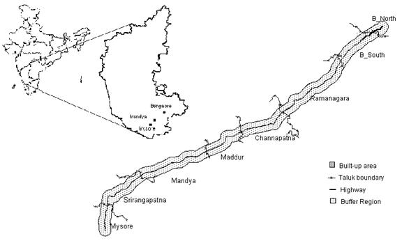
Study Area This study was carried out in the Bangalore - Mysore highway, between 12o 19’ 30’’ N to 13o 01’ 15’’ N latitudes and 76o 45’ 30’’ E to 77o 31’ 44’’ E longitudes. Eight taluks straddle the Bangalore – Mysore highway as well as areas adjacent to these, which have been influenced by the highway. It includes Mysore taluk of Mysore district, Srirangapatna, Mandya and Maddur taluks of Mandya district, Channapatna, Ramanagaram, Bangalore South and Bangalore North taluks of Bangalore district. This is one of the well-linked regions of Karnataka state and covers an area of 4,152 sq. km with about 1,013 settlements. This segment happens to be one of the prime urban corridors of the state. The cities like Mysore, Srirangapatna and Bangalore has been capitals of erstwhile kingdoms and so naturally development has its effect since historical time. However expansion of Bangalore in recent times, as a major economic centre with development of industries and commercial establishments have given impetus to the growth. Early 90’s boom in the software sector with consequent infrastructure initiatives, has contributed to hike in population, mainly due to migration from less developed pockets of India (Orissa, Bihar, etc.) to Karnataka. The radial sprawl due to Bangalore city’s growth is seen curbing smaller villages on the periphery. The present investigation analyse the growth pattern within a buffer of 4 km across the roads connecting Bangalore with Ramanagaram, Ramanagaram with Channapatna, Channapatna with Maddur, Maddur with Mandya, Mandya with Srirangapatna and Srirangapatna with Mysore (Figure 1).
|