 |
Modeling and Simulation of Urbanisation in Greater Bangalore, India |
 |
1Energy and Wetlands Research Group, Centre for Ecological Sciences [CES],
2Centre for Sustainable Technologies, 3Centre for infrastructure, Sustainable Transportation and Urban Planning (CiSTUP),
Indian Institute of Science, Bangalore – 560012, India.
*Corresponding author: cestvr@ces.iisc.ac.in
|
STUDY AREA
Bangalore the IT hub of India is located in the southern part of the country of Karnataka state. The region was known as “Bendakaaluru” (land of boiled beans), “land of lakes” where a large number of lakes were constructed to store water, during the regime of erstwhile princely state. Numerous parks, gardens such as Lalbhag, Cubbon Park etc. exist in the region, which aptly gave the name “Garden City”. However, during the post-independence due to industrialization, unplanned urbanisation the city has witnessed the decline in parks as well as water bodies / lakes. With the spurt in IT industries in the region during late 1990’s, the city was termed “Silicon Valley”. This policy interventions created job opportunities to different category of people.The city has grown spatially during the last year by 10 times and the current spatial extent is about 741 km2.
Geographically Bangalore is located in the Deccan plateau, toward the south east of Karnataka state extending from 12o49’5”N to 13o8’32”N and 77o27’29” E to 77o47’2”E. To account for developments in the peri urban regions, the study area includes ten km buffer (from the administrative boundary)with a gross area of over 2250 km2 as shown in Fig. 1. Bangalore has spatially increased from 69 sq.km (1901) to 741 sq.km (2006) [1]. The decadal (2001 to 2011) increase in population for urban areas of India is 31.8% and in Karnataka is 31.5%, but Bangalore has a decadal increase of 44% very large compared to that of the state and country. The population has increased from 5.8 Million in 2001 (BMP – Bangalore Mahanagara Palike limits) to 8.4 Million in 2011 (current spatial extent of 741 sq.km, under jurisdiction of BBMP- Bruhat Bangalore Mahanagara Palike) [34,35]. The population density has increased from 7880 persons per square kilometer to over 11330 persons per square kilometer during the last ten years [34,36]. Bangalore receives an annual average rainfall of 896 mm [35,37]. The undulating terrain varying from about 700 m to about 962m AMSL in the region has resulted in the formation of large number of drainage network with inter connected lakes. Vegetation and water bodies are responsible for moderating the local climate and cooler days during summer.
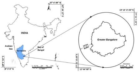
Fig.1. Study Area- greater Bangalore with 10 km buffer
Geologically [38][39], the prevailing rocks are light to dark grey Biotitic Granitic Gneiss and varies from place to place in texture, structure and appearance based on the fineness or coarseness of the grains, mode of disposition of dark minerals.
The drainage network in Bangalore flows to Cauvery through its tributaries Arkavathi (East flowing), Pinakini/Pennar (East Flowing) and Shimsha (West Flowing). The central, northern and eastern portion is undulating with the upland tracts occupied by scrubs, while the low lands occupied by series of tanks formed by embanking the streams along the valley for irrigation purposes. These valleys vary in size with small ponds to large lakes. The southern portion of the land consists of hills that are close together and are surrounded by thick jungles.
|
|
Citation : Bharath H Aithal, Vinay S, Durgappa S and Ramachandra T V, Modeling and Simulation of Urbanisation in Greater Bangalore, India, Proc. of National Spatial Data Infrastructure 2013 conference, IIT Bombay, November 29-30, 2013
|