Objective: To estimate the water yield in a catchment (of a lake, pond, stream or river).
Table1: Classification of Catchments in India
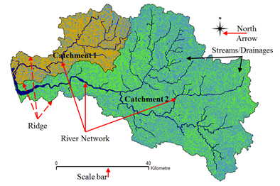
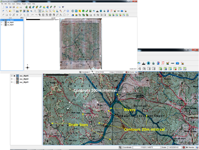
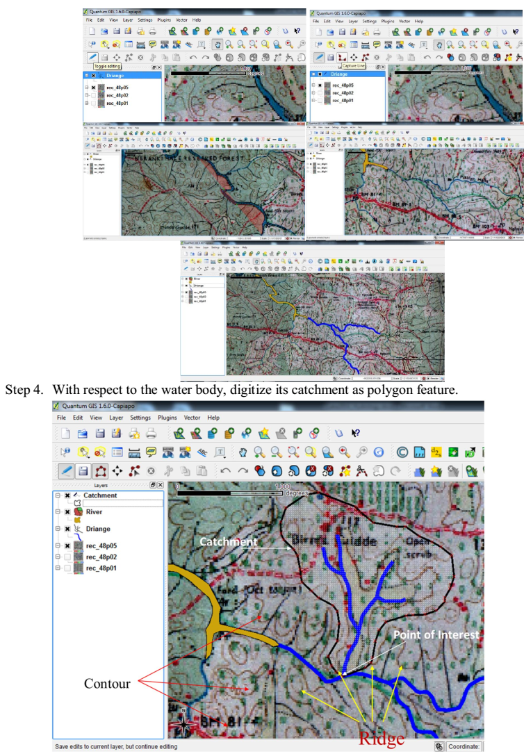
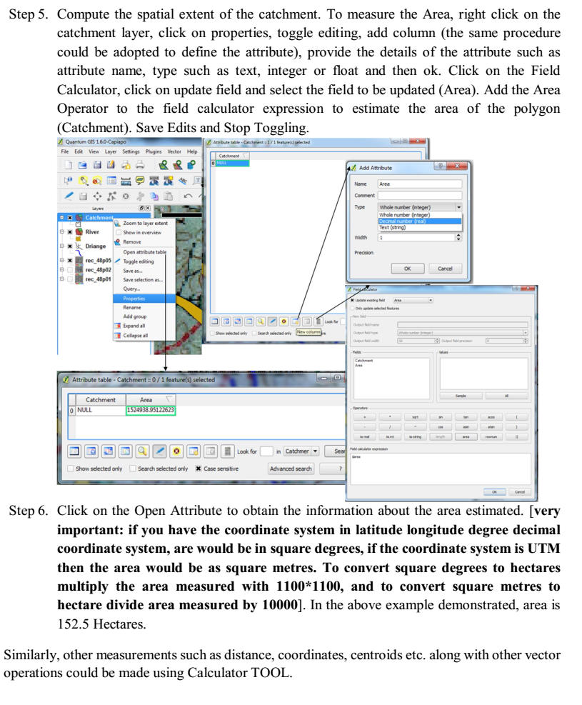
Source: http://fes.org.in/source-book/SWC%20Source%20Book_final.pdf Contours: Contours are the imaginary lines on the earth surface with equal elevation. In a topographic map of 1:50000 scale, contours are at every 20 metre interval. Contours with decreasing altitudes with respect to an higher altitude contour indicates hillock, on the contrary increasing contours along a low altitude contour indicates Valley. step1. Scan the respective topographic map a. Create New features as line or polygon
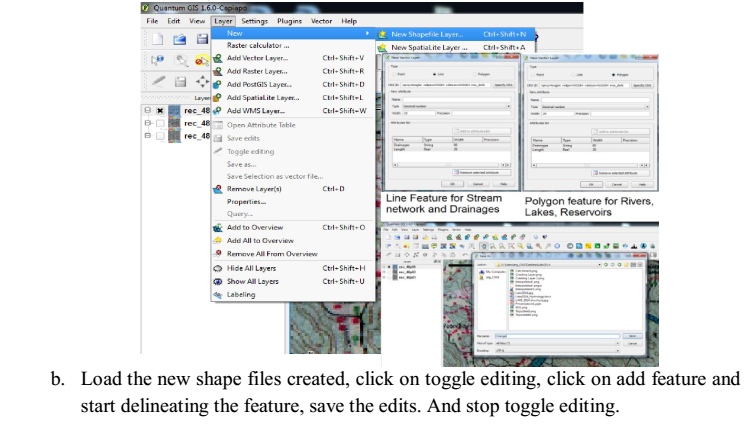
Go to Layers, New Shape file Select Line or Polygon feature based on the feature to be delineated, add attributes and save.
Assessment of water yield: Water yield or Surface Runoff is the precipitated water that drains to a water body in a catchment. Surface runoff occurs during monsoon. Factors affecting Runoff are the Slope, Drainage, Land use, Soil Characteristics, Rainfall. The total quantity of water that can be expected in a stream in a given period of time such as monthly, annual etc… is referred to as Runoff Yield. Runoff Yield (Q) as kilo.cubic metre (Million Litres) is estimated empirically (eq.1) as a function of Rainfall (P) in mm and Area under different land uses (A) in Hectares. Runoff Coefficient under different land use is as specified in table 2.
Water Yield Estimation
|
|||||||||||||||||||||||||||||||||||||||||||||||||||||||||||||||||||||||||||||||||||||||||||||||||||||||||||||||||||||||||||||||||||||||||||||||||||||||||||||||||||||||||||||||||||||||||||||||||||||||||||||||||||||||||||||||||||||||||||||||||||||||||||||||||||||||||||||||||||||||||||||||||||||||||||||||||||||||||||||||||||||||||||||||||||||||||||||||||||||||||||||||||||||||||||||||||||||||||||||||||||||||
Centre for Sustainable Technologies,
Centre for infrastructure, Sustainable Transportation and Urban Planning (CiSTUP),
Energy & Wetlands Research Group, Centre for Ecological Sciences, Indian Institute of Science, Bangalore – 560 012, INDIA.
E-mail : cestvr@ces.iisc.ac.in
Tel: 91-080-22933099/23600985, Fax: 91-080-23601428/23600085
Web: http://ces.iisc.ac.in/energy
Energy & Wetlands Research Group, Centre for Ecological Sciences, Indian Institute of Science, Bangalore – 560 012, INDIA.
E-mail: asulabha@ces.iisc.ac.in
Energy & Wetlands Research Group, Centre for Ecological Sciences, Indian Institute of Science, Bangalore – 560 012, INDIA.
E-mail: bharath@ces.iisc.ac.in
Energy & Wetlands Research Group, Centre for Ecological Sciences, Indian Institute of Science, Bangalore – 560 012, INDIA.
E-mail: settur@ces.iisc.ac.in
Energy & Wetlands Research Group, Centre for Ecological Sciences, Indian Institute of Science, Bangalore – 560 012, INDIA.
E-mail: durgamadhab@ces.iisc.ac.in
Energy & Wetlands Research Group, Centre for Ecological Sciences, Indian Institute of Science, Bangalore – 560 012, INDIA.
E-mail: gouri@ces.iisc.ac.in
Energy & Wetlands Research Group, Centre for Ecological Sciences, Indian Institute of Science, Bangalore – 560 012, INDIA.
E-mail: harishrbhat@gmail.com
Energy & Wetlands Research Group, Centre for Ecological Sciences, Indian Institute of Science, Bangalore – 560 012, INDIA.
E-mail: sincy@ces.iisc.ac.in
Energy & Wetlands Research Group, Centre for Ecological Sciences, Indian Institute of Science, Bangalore – 560 012, INDIA.
E-mail: sudarshan@ces.iisc.ac.in
Energy & Wetlands Research Group, Centre for Ecological Sciences, Indian Institute of Science, Bangalore – 560 012, INDIA.
E-mail: vinay@ces.iisc.ac.in
| Contact Address : | |||
| Dr. T.V. Ramachandra Energy & Wetlands Research Group, Centre for Ecological Sciences, TE 15, New Biology Building, Third Floor, E Wing, [Near D Gate], Indian Institute of Science, Bangalore – 560 012, INDIA. Tel : 91-80-22933099 / 22933503-extn 107 Fax : 91-80-23601428 / 23600085 / 23600683 [CES-TVR] E-mail : cestvr@ces.iisc.ac.in, energy@ces.iisc.ac.in, Web : http://wgbis.ces.iisc.ac.in/energy |
|||