|
Ajjawara watershed is located in Chikballapur Taluk of Chikballapur District, Karnataka (Figure 5.1). Extending between 13.3948° to 13.5111°N and 77.6741 to 77.8107 °E, Ajjawara catchment has as area of 122.14 km2, covering about 71 villages (Figure 5.1).
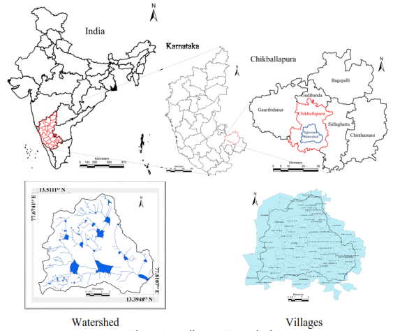
Figure 5.1: Ajjawara Watershed
Ajjawara watershed is bounded by Rocky hills in the west. Elevation in the watershed varies between 888m to 1427m AMSL (Figure 5.2). Slopes (Figure 5.2) are gentle across the catchment and steep at the hillocks. Slope ranges between 0% to 88.14%.
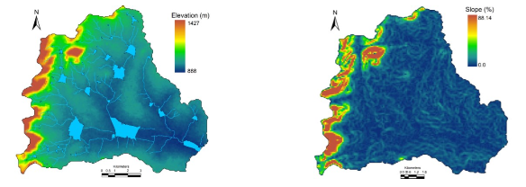
Figure 5.2: Topography
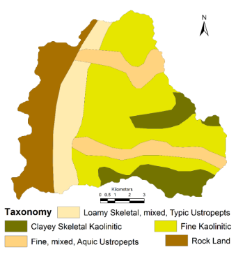
Figure 5.3: Soil
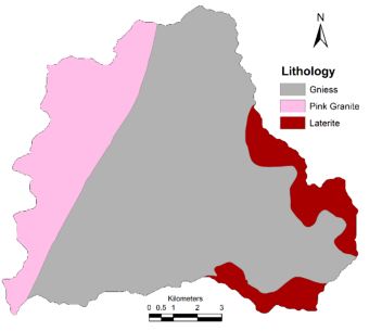
Figure 5.4: Geology
Soils vary between loamy to clayey (Figure 5.3) (http://eusoils.jrc.ec.europa.eu/, National Bureau of Soil Survey and Land Use Planning). Rock type includes Gneiss, Pink Granite and Laterite (Figure 5.4). Ground water status is as depicted in Figure 5.5 (Central Ground Water Board), on an average in the catchment, Ground water is under moderate condition.
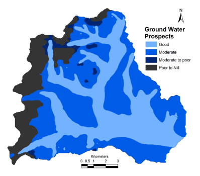
Figure 5.5: Ground Water Status
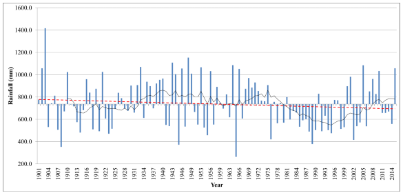
Figure 5.6: Rainfall regime (Annual Rainfall in Chikballapur)
Rainfall analysis was carried out in the catchment between 1901 to 2015. Rainfall variations across time and space is as depicted in Figure 5.6 to Figure 5.8 and Table 5.1. Average rainfall in the catchment is about 698 mm (Median). Analysis of annual rainfall in the catchment shows that rainfall is below average for long duration since 1980’s. Rainfall in the catchment is highly variable across time, it can be observed that normal rainfall occurs with a return period of 2.5 years where as Drought or excess rainfalls occurs at a return period of 3.3 years. Spatial distribution of rainfall is as depicted in Figure 5.8, across space, rainfall varies between 750 mm to 900 mm.
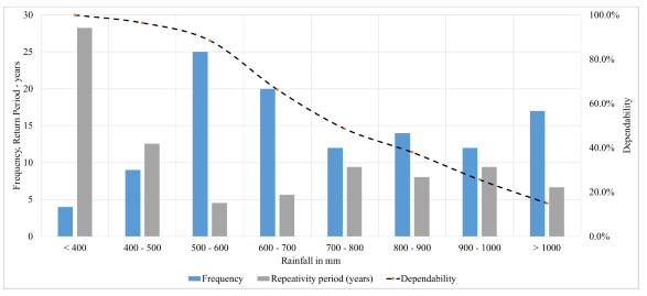
Figure 5.7: Rainfall Characteristics – Frequency, Dependability and Return Period
Table 5.1: Rainfall Characteristics
Rainfall (mm) |
Frequency |
Probability of Occurrence |
Dependability |
Return Period (years) |
< 400 |
5 |
4 |
100.0% |
28 |
400 - 500 |
15 |
9 |
96.5% |
13 |
500 - 600 |
12 |
25 |
88.5% |
5 |
600 - 700 |
19 |
20 |
66.4% |
6 |
700 - 800 |
21 |
12 |
48.7% |
9 |
800 - 900 |
15 |
14 |
38.1% |
8 |
900 - 1000 |
4 |
12 |
25.7% |
9 |
> 1000 |
2 |
17 |
15.0% |
7 |
Minimum |
263 mm |
Maximum |
1416 mm |
Mean |
736 mm |
Median |
698 mm |
Standard Deviation |
±216 mm |
Coefficient of Variation |
0.29 |
Indian Meteorological Department – Rainfall Distribution All India Scenario |
Rainfall Distribution |
Condition |
Rainfall |
Probability of Occurrence |
Return Period (Year) |
Excess |
> 20% Average |
> 883 mm |
0.29 |
3.4 |
Normal |
± 20% Average |
588 – 883 mm |
0.40 |
2.5 |
Drought |
-20% Average to - 60% Average |
294 – 588 mm |
0.30 |
3.3 |
Severe Drought |
> -60% Average |
< 294 mm |
0.01 |
113 |
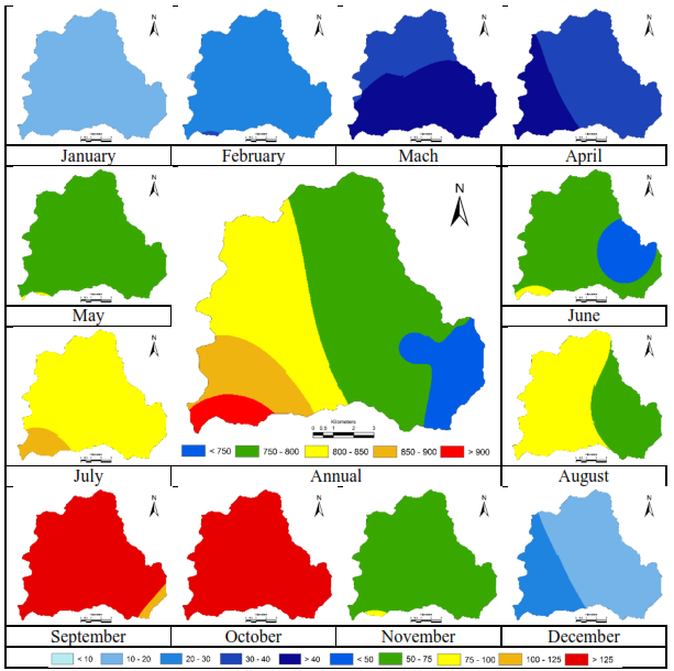
Figure 5.8: Spatial Distribution of Rainfall (All units in mm)
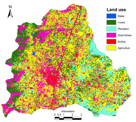
Figure 5.9: Land use
Land use of 2016 was assessed using Landsat 8 data (resolution 30 m). Signatures were collected from Google earth and field visit. Gaussian Maximum likelihood classifier was used to classify the satellite image to 6 categories namely Water, Forest, Plantation, Open lands, Built-up and Agriculture. The results of Land use is as presented in Figure 5.9 and Table 5.2. Ajjawara catchment is dominated with Agriculture lands (3.3%) followed by Forest patch in that occurs on Hill and surrounding the West. Major Cereals in the catchment are Ragi and Maize, Pulses include Avare, Horsegram, Tur, Fruits and Vegetables are also grown extensively. Figure 5.10 depicts Google earth image of the catchment.
Table 5.2: Land use
Land Use |
Area |
Hectare |
% |
Water |
81.72 |
0.67 |
Forest |
2764.08 |
22.63 |
Plantation |
1889.46 |
15.47 |
Open |
2355.84 |
19.29 |
Built up |
687.06 |
5.62 |
Agriculture |
4436.91 |
36.32 |
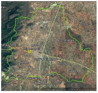
Figure 5.10: Google EarthKolar (Kolar +Chikballapur districts) Tree list
Dry Deciduous forests: Generally found in higher elevations like Antaragange range forests with good amount of rain fall. The important species are: |
AVENUE TREES: These includes those trees planted along the roadsides and those growing in village limits. They include: |
- Azadirachta indica
- Bauhinia racemosa
- Bombax cieba
- Bridelia crenulata
- Bridelia crenulata
- Butea monosperma
- Cassia fistula
- Cassina glauca
- Cochlospermum religiosum
- Dalbergia sympathetica
- Diospyros chloroxylon
- Diospyros melanoxylon
- Ficus racemosa
- Ficus tinctoria
- Grewia laevigata
- Holarrhena pubescens
- Lagerstoemia parviflora
- Phyllanthus emblica
- Pongamia pinnata
- Terminalia alata
- Terminalia bellarica
- Wrightia tinctoria
|
- Acacia nilotica
- Aegle marmelos
- Albizzia lebbeck
- Arachis hypogea
- Artocarpus integrifolia
- Azadirachta indica
- Butea monosperma
- Dalbergia sissoo
- Delonix regia
- Ficus benghalensis
- Ficus racemosa
- Ficus religiosa
- Holoptelia integrifolia
- Jacaranda acutifolia
- Madhuca indica
- Mangifera indica
- Melia dubia
- Michelia champaka
- Millingtonia hortensis
- Phyllanthus emblica
- Pongamia pinnata
- Prosopis juliflora
- Samanea saman
- Spathodea companulata
- Syzygium cumini
- Tabuebia arjentia
- Tabuebia rosea
- Tamarindus indica
- Terminalia arjuna
- Thespesia populnea
- Vitex negundo
|
THORN SCRUB FOREST: This spreads over places having a very dry climatic conditions like Muduvadi range forest, dry hills of Antaragange etc. They inhabit very small stunted trees like:
- Acacia leucophloea
- Diospyros chloroxylon
- Diospyros montana
- Santalum album
- Ziziphus jujuba
|
SECONDARY FORESTS: Consists of forest tree plantations mostly for timber purposes. Common plantation species are:
- Albizzia amara
- Albizzia lebbeck
- Cassia siamea
- Dalbergia sissoo
- Gliricedia sepium
- Tamarindus indica
- Tectona grandis
|
ORCHARDS
Most of the villages have one or the other fruit orchards like in village Kondasandra most of the areas are mango cultivated, hence covering nearly half of the village. It may be intermixed with trees like Anacardium occidentale, Tamarind, etc.
- Anacardium occidentale
- Mangifera indica
- Manilkara zapota
- Psidium guajava
|
GROOVES AND PLANTATIONS: Kolar being a dry district, one hardly finds a continuous or large patch of forests. However, small grooves or clumps of trees like Pongamia pinnata, Wrightia tinctoria, Azadirachta indica are found along the edges and borders of fields and in waste lands. Large plantations of hardy fuel trees, which survive in Kolar’s dry climate (depends on scanty rainfall) have been planted both by farmers and by the forest department under social forestry programme.
- Acacia nilotica
- Azadirachta indica
- Casuarina equisetifolia
- Cocus nucifera
- Pongamia pinnata
- Tamarindus indica
- Tectona grandis
|
COMMON FUEL AND TIMBER TREES: Household surveys conducted in selected households of Kolar, indicates high dependence on bio resources (such as fuel wood, agricultural residues, etc.) for cooking, etc. Preferred tree species for fuel wood are Eucalyptus, Pongamia, etc. As more number of lakes are drying due to various reasons like siltaton, encroachment of those natural and manmade channels which bring them water, many of these wetlands like Holali tank of Huthur have been fully planted by timber and fuel trees like Acacia nilotica, Prosopis juliflora etc. More and more farmers have long back started planting Eucalyptus and other fuel trees discarding their traditional farming due to poor yeild, depletion of water table in wells and borewells and erratic electricity supply. Common fuel wood and timber species are: Acacia auriculiformis, Acacia nilotica, Azadirachta indica, Cassia fistula, Cassia siamea, Casuarina equisetifolia, Eucalyptus sp., Gliricidia sepium, Jatropha sp., Pongamia pinnata, Prosopis juliflora, Tectona grandis, etc.
|