|
Freshwater ecosystems are aquatic systems include lakes and ponds, rivers and streams, wetlands and groundwater. They provide the majority of our nation's drinking water resources, water resources for agriculture, industry, sanitation, as well as food including fish. They also provide recreational opportunities and a means of transportation. In addition, freshwater ecosystems are home to numerous organisms (e.g., fish, amphibians, aquatic plants, and invertebrates). It has been estimated that 40% of all known fish species on Earth come from freshwater ecosystems. We obtain freshwater from surface water and groundwater. These make up only a small quantity of the world’s water. Freshwater may be present as: Groundwater, Wetlands, Lakes and Ponds, Rivers and streams, etc.
1.1 Wetlands: A wetland is a place where water is the primary factor controlling the immediate environment. Wetlands can be as small as a pool or as large as a lake. Wetlands generally occur where land and water meet and underground water is at or near the surface, or where land is covered with water less than six feet deep. The water level in a wetland rises and falls. This shift may depend on location, weather, climate, or surrounding ecosystems. The area may be temporarily saturated, then dry up until another watery inundation. Meanwhile, a wetland provides a rich home to many animals and plants. What we call the rivers, lakes etc. comes under the category of wetlands. Wetlands are important for so many reasons:
-
Wetlands aid in remediation and act as ‘kidneys of a landscape’;
-
Wetlands prevent flooding by holding water much like a sponge. By doing so, wetlands help in keeping river levels normal and filter and purify the surface water.
-
Wetlands accept water during storms and whenever water levels are high. When water levels are low, wetlands slowly release water.
-
Wetlands also release vegetative matter into rivers, which helps feed fish in the rivers. Wetlands help to counter balance the human effect on rivers by rejuvenating them and surrounding ecosystems.
-
Many animals that live in other habitats use wetlands for migration or reproduction. For example, herons nest in large old trees, but need shallow areas in order to wade for fish and aquatic life. Amphibians often forage in upland areas but return to the water to mate and reproduce.
-
While wetlands are truly unique, they must not be thought of as isolated and independent habitat. To the contrary, wetlands are vital to the health of all other biomes and to wildlife and humans everywhere.
-
Unlike most other habitats, wetlands directly improve other ecosystems.
-
Looking at pictures of deltas one can tell that rivers deposit a lot of sediment into the ocean. The sediment is the top soil that has been eroded and washed away.
-
Emergent plants firmly rooted in the muddy bottom but with stalks that rise high above the water surface) are able to radically slow the flow of water. As a result, they counter the erosive forces of moving water along lakes and rivers, and in rolling agricultural landscapes. Erosion control efforts in aquatic areas often include the planting of wetlands plants.
- Wetlands and Water Purification: Wetlands also clean the water by filtering out sedimentation, decomposing vegetative matter and converting chemicals into useable form.
- Supports local livelihood: Valuation of goods and services from a relatively pristine wetland in Bangalore shows the value of Rs. 10,435/ha/day (much higher than global coastal wetland ecosystems with a total annual of US$ 14,785/ha), while the polluted wetland shows the value of Rs.20/ha/day (Ramachandra et al., 2005) and sewage fed Varthur wetland has a value of Rs.119/ha/day (Ramachandra et al., 2011).
- Anthropogenic activities particularly, indiscriminate disposal of industrial effluents and sewage wastes, agricultural runoff have altered the physical, chemical as well as biological integrity of the ecosystem. This has resulted in the ecological degradation, which is evident from the current ecosystem valuation of wetlands.
The ability of wetlands to recycle nutrients makes them critical in the overall functioning of earth. No other ecosystem is as productive, nor as unique in this conversion process. In some places artificial wetlands were developed solely for the purpose of water purification.
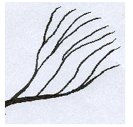
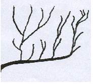
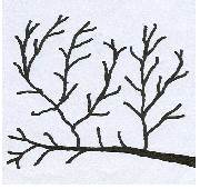
1.2 Rivers and Streams: Although there are many rivers and streams, these sources of running water account for a very small portion of the earth's total surface, just 0.3%. Rivers and streams describe natural and man-made bodies of moving water. These systems consist of numerous tributaries joined together to form a main channel. Rivers may sometimes be ephemeral, carry water only during and immediately after a rain, they may be intermittent, flow part of the year, or they may be perennial, flow all the year round. The tributaries (streams) are identified by their stream order, denoted by its position in the system (Table 1.1, Figure 1.1).
Table 1.1: Stream Orders and their Characteristics
Stream Order |
Characteristics |
First Order |
Not connected to any other tributary |
Second Order |
Connected to one other stream/tributary |
Third Order |
Joining of two second order streams |
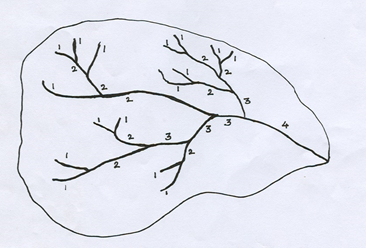
Figure 1.1: Catchment / watershed with streams (first, second, etc.)
Where gradients (slopes) are steep and near the source of the river or stream, water travels in a straight channel, velocity is high and much sediment is carried. Upon reaching ground-level, velocity decreases and sediments are dropped in the form of silt, mud, and sand. As a river or stream channel builds up or erodes the surrounding floodplain, it meanders, creating loops of varying sizes in the channel. When meanders become extremely distorted they can be severed, becoming independent oxbow lakes. The combined effects of climate and geology on the topography yield an erosion pattern, which is characterized by a network of streams. Some of the frequently observed stream patterns are given in the Table 1.2.
Table 1.2: stream patterns
Type of stream pattern |
Description |
Illustration |
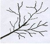
Dentric |
When a region is homogenous offering no variation in the resistance to the flow of water, the resulting streams run in all directions without definite preference to any one particular region. |
|
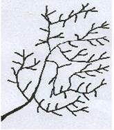
Trellis |
This pattern develops when the underlying rock is strongly folded or sharply dipping. The longer streams will have preference to one particular orientation and the other tributaries will have an orientation and the tributaries will have an orientation at right angles to this. |
|
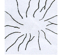
Radial |
The drainage pattern from dome Mountains and volcanoes is of radial type where the streams emanate from a central focus and flow radially outward. |
|
Parallel |
The internal geological structure of the land, sometimes the parallel and sub parallel patterns are formed. The most of the streams run in the same direction is the main characteristic feature |
|
Sub parallel |
The internal geological structure of the land, sometimes the parallel and sub parallel patterns are formed. The most of the streams run in the same direction is the main characteristic feature |
|
Annular |
The streams, which form in the weaker strata of the dome mountain, indicate approximately circular or annular pattern. The annular pattern may be treated as a special form of trellis pattern. |
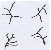
|
Rectangular |
A region consisting of many rectangular joints and faults may produce a rectangular drainage pattern with streams meeting at the right angle. |
|
Pinnate |
In pinnate stream pattern, all the main streams run in one direction with the tributaries joining them at an oblique angle.
|
|
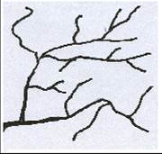
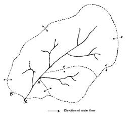
Collectively the network of rivers and streams forms a watershed (Figure 1). Thus, river, pond, wetlands, lake or estuary is an ultimate destination of all water running downhill through an area of land, which is referred as watershed.
1.3 WATERSHED: A watershed describes an area of land that contains a common set of streams and rivers that all drain into a single body of water such as a tributary, river, a lake or an ocean. It represents a catchment basin bounded by topographic features, such as ridge tops and performs primary functions of the ecosystem with biotic and abiotic components. The word watershed is sometimes used interchangeably with drainage basin or catchment. Ridges and hills that separate two watersheds are called the drainage divide. The watershed consists of surface water--lakes, streams, reservoirs, and wetlands--and all the underlying ground water.
A watershed can cover a small or large land area. All the streams flowing into small rivers, larger rivers, and eventually into the ocean, form an interconnecting network of waterways as shown in Figure 1.2. In a large watershed, water from precipitation will interact and leach minerals from the soil before being discharged into the lake or river. Lakes with small watersheds, maintained primarily by groundwater flow, are known as seepage lakes. Whereas, lakes fed by inflowing streams or rivers are known as drainage lakes.
Not only does water run into the streams and rivers from the surface of a watershed, but water also filters through the soil, and some of this water eventually drains into the same streams and rivers. There can be sub watersheds within a watershed like a tributary to a river having its own watershed, which is a part of the larger total drainage area to the river. The network of streams and rivers that drain our watershed, ultimately empty into larger bodies of water, such as lakes and oceans.
 |
|
Figure 1.2: A Typical Watershed |
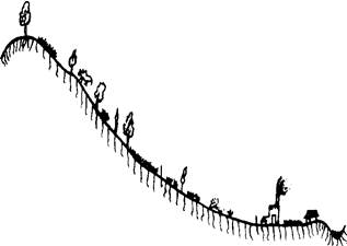
Figure 1.3: A Typical Watershed Transect (macro-perspective) |
Watershed plays a critical role in the natural functioning of the ecosystem (Ramachandra, 2002) such as:
- Hydrologically, watersheds integrate the surface water run-off of an entire drainage basin. It captures water from the atmosphere. Ideally, all moisture received from the atmosphere, whether in liquid or solid form, has the maximum opportunity to enter the ground where it falls. The water infiltrates the soil and percolates downward. Several factors affect the infiltration rate, including soil type, topography, climate, and vegetative cover. Percolation is also aided by the activity of burrowing animals, insects, and earthworms.
- It stores rainwater once it filters through the soil. Once the watershed's soils are saturated, water will either percolate deeper, or runoff the surface. This can result in freshwater aquifers and springs. The type and amount of vegetation, and the plant community structure, can greatly influence the storage capacity in any one watershed. The root mass associated with healthy vegetative cover keeps soil more permeable and allows the moisture to percolate deep into the soil for storage. Vegetation in the riparian zone affects both the quantity and quality of water moving through the soil (Figure 1.3).
- Finally, water moves through the soil to seeps and springs, and is ultimately released into streams, rivers, and the ocean. Slow release rates are preferable to rapid release rates, which result in short and severe peaks instream flow. Storm events which generate large amounts of run-off can lead to flooding, soil erosion and siltation of streams.
- Ultimately, the moisture will return to the atmosphere by way of evaporation. The hydrologic cycle (the capture, storage, release, and eventual evaporation of water) forms the basis of watershed function. Economically, they play a critical role as sources of water, food, hydropower, recreational amenities, and transportation routes.
- Ecologically, watersheds constitute a critical link between land and sea; they provide habitat -- within wetlands, rivers, and lakes - for 40 percent of the world's fish species, some of which migrate between marine and freshwater systems.
- Watersheds also provide habitat within the terrestrial ecosystems such as forests and grasslands - for most terrestrial plant and animal species; and they provide a host of other ecosystem services -- from water purification and retention to flood control to nutrient recycling and restoration of soil fertility -- vital to human civilizations.
Humans alter a watershed by paving over land and constructing buildings. This will affect how water flows over the land and may cause harmful materials to flow directly into the water. This will affect the organisms that depend on the water for survival. For example, polluted water may cause these organisms to die leaving the fish with no food.
Soil types and their susceptibility to erosion is another important component of the watershed. The type and abundance of vegetation determines the extent of erosion. Areas with native undisturbed vegetation like forests are less prone to erosion than areas with disturbed vegetation like agricultural lands. Factors influencing watershed operations are:
- Size: Both run-off volume and rate increases with increase in watershed size. However, both rate and volume per unit of watershed area decreases as the area increases. The size or area of watershed is an important parameter in determining the peak rate of run-off. Based on the size, watershed is classified as micro (0-10 ha), small (10-40), mini (40-200), sub-watershed (200-400) and macro (400-1000 ha)
- Shape: Long and narrow watersheds have longer times of concentration resulting in lower runoff-rates than more square watersheds of similar size, which have a number of tributaries discharging into the main channel. This type of concentration also affects the amount of water infiltrating into the soil in the watershed. The longer time it takes to leave the watershed, the greater is its seepage into the soil.
- Land-slope: Slope has major implications on land-use. The speed and extent of run-off depend on the slope of the land. Greater the slope, greater is the velocity of flow of run-off water. If velocity is doubled, energy and consequently erosion also increases. The degree of slope sets limits on land use for annual crops, plantation and land reclamation, depending on soil depth.
- Drainage pattern: Drainage pattern of an area depends on the course of the streams and their tributaries. Land-slope, lithology and structure influence the drainage pattern. In general, coarser the drainage texture, higher is the conductivity. Finer drainage texture results in heavier soil type. Drainage patterns act as guidelines to locate vulnerable areas requiring different kinds and degrees of soil conservation measures.
- Soil and geology: Soil and geology of the watershed also determine the amount of water percolating into the ground. Soil character also determines the amount of silt that will be washed down into water harvesting structures.
- Vegetative cover: The type and quality of vegetative cover of the watershed influence run-off, infiltration rates, erosion, sediment production and evapotranspiration rate. Dense native vegetation reduces erosion and also increases infiltratration.
- Precipitation: Amount and nature of precipitation is an important factor determining the rate of run-off into the water body. Rainfall distributed evenly throughout the year has a different impact than a sudden sharp seasonal rainfall.
Watershed management is a term used to describe the process of implementing land use practices with soil conservation and water management practices to protect and improve the quality of the soil, water and other natural resources within a watershed by managing the use of those land and water resources in a comprehensive manner. Watershed management implies an effective conservation of soil and water resources for sustainable production with minimum external inputs. It involves management of land surface and vegetation so as to conserve the soil and water for immediate and long term benefits to the farmers, community and society as a whole. Objectives of the watershed management are (i) sustenance of natural resources, (ii) production of food, fodder, fuel, etc., (iii) pollution control, (iv) water storage, flood control, arresting sedimentation. (v) Wild life preservation, (vi) erosion control and prevention of soil, degradation and conservation of soil and water, (vii) employment generation through industrial development dairy fishery production, (viii) recharging of ground water to provide regular water supply for domestic and agriculture use and(ix) recreational facility.
The various measures adopted under watershed management are (a) vegetative barriers; (b) building of contour bunds along contours for erosion; (c) furrow/ and ridges method of cultivation across the slope; (d) irrigation water management through water efficient drip and sprinkler methods, and (e) planting of horticultural contour species on bunds. Thus, watershed management recognizes the judicious management of basic natural resources - soil water and vegetation, on watershed basis, for achieving sustainable livelihood of dependent people. It includes treatment of land through biological as well as engineering measures.
Integrated Watershed Management (IWM) is the process of managing human activities and natural resources on a watershed basis. This approach allows us to protect important water resources, while at the same time addressing critical issues such as the current and future impacts of rapid growth and climate change. Watershed planning entails (i) preparation of base maps, (ii) reconnaissance survey of the watershed, (iii) assessing rainfall characteristics, (iv) Preparation of soil maps and classification of lands for different uses according to capability classification for agriculture, forestry, pasture, horticulture, etc., (v) land use analyses and temporal land cover dynamics, (vi) appraisal of agricultural production patterns and potentials, (vii) carrying out topographic and hydrologic surveys, (viii) geo-hydrological survey to identify regions for groundwater development, (ix) formulation of an integrated time-bound plan for land and moisture conservation, ground water. recharge, development of productive afforestation of native specis, agriculture production, grasslands and horticulture and (x) assessment of the social costs and benefit with participatory approaches in the management.
Objectives: Objectives of the current research are (i) land use analysis of Kolar (kolar and Chikballapur districts), (ii) rainfall trend analyses, (ii) assessment of hydrological status and (iv) investigation of a typical watershed (case study)
|