|
|
ENVIS Technical Report 125, September 2017 |
 |
Ecologically Sensitive Regions in the Kali River Basin, Karnataka:
Delineation based on Ecological Principles and People’s Livelihood |
 |
INTRODUCTION
Ecosystems are the distinct biological entities that sustain the biosphere and characterised by a range of functions: nutrient cycling, bio-geo chemical cycle, hydrologic cycling, etc. Ecological sensitivity of ecosystems refers to their ability to cope with various kinds of environmental disturbances that have the potential of adversely changing the character of the natural landscapes. The conservation and sustainable management of ecosystems are the vital components in the pursuit of development goals that are ecologically, economically and socially sustainable. Sustainable development of a region requires a synoptic ecosystem approach that relates to the dynamics of natural variability and the effects of human interventions on key indicators of biodiversity and productivity (Ramachandra et al. 2007). This requires an understanding of the complex functioning of ecosystems, diversity of resources, values, ecological services and their significant ability in influencing climate at local as well as global scale.
Landscape with a mosaic of interconnected forest and non-forest patches constitute a complex ecological, economic and socio-cultural systems. Forests are playing a crucial role in sustaining life on the earth through maintaining ecological diversity, regulating climate, carbon sequestration, protecting soil and hydrology etc., They provide abundant resources and livelihoods for the world’s population (Gibson et al., 2011; Hansen et al., 2013). Forest ecosystems offer numerous resources such as timber and non-timber forest products (NTFP), medicinal resources, fuelwood and as well provide recreational values (Kindstrand et al. 2008). They act as prime biodiversity repositories (Li et al., 2009) and mitigate global warming (Cabral et al., 2010) by absorbing 30 % of fossil fuel CO2 emissions (Pan et al., 2011). The goods and services provided by forested landscapes are vital to the socioeconomic development of human populations (DeFries et al., 2004) and their survival (Ramachandra et al., 2016). However, the forests are being altered due to the uncontrolled anthropogenic activities such as industrialization, agriculture, deforestation, etc. affecting their structure and health. Forests cover about 31% today at globally as opposed to 50% of the earth's land area 8000 years ago depleted with the expanded extents of croplands, pastures, plantations, and urban areas (FAO, 2011). The Earth's land surface has lost 40 percent of natural forest by 1990 due to the expansion of cropland and permanent pasture (Ramachandra & Shruthi, 2007). The rapid conversion of forests for agriculture, timber production, infrastructure activities and other anthropogenic uses has generated vast, human-dominated landscapes with potentially calamitous consequences for biodiversity to sustain. Despite realizing the importance of these ecosystems, increasing awareness global deforestation rates have remained alarmingly high over the past decades (DeFries et al., 2010).
Land use Land cover (LULC) information of a forested landscape serves as a basis for understanding bio-geophysical processes and anthropogenic pressures on the ecosystem. The land cover is referred as biophysical attributes of the earth’s surface and land use as human purpose or intent applied to effective usage of these biophysical attributes (Lambin et al., 2001). LULC changes include the land transformation from one land use to another, leading to land degradation with the decline of biological, ecological, hydrological and economic productivity. LULC change resulting in deforestation has been recognized as an important driver of global environmental change. This necessitates quantification of LULC changes to evolve sustainable natural resource management strategies. The uncontrolled LU changes in forest landscapes subdivide the continuous native forests to more and smaller sizes and isolated forest patches (Laurance et al., 2002; Bharath et al., 2012). Fragmentation is enumerated as a process of breaking contiguous natural forest patches into smaller tracts of forest surrounded by other land uses, causing a disruption in continuity of the natural landscape (Ramachanra et al., 2016). Habitat fragmentation with subsequent edge effects caused by linear projects, infrastructure developments influence ecosystem goods and services including carbon sequestration, hydrologic regime, and biodiversity (Vinay et al., 2013; Bharath et al., 2014). The edge effect will lead to often perishing of large trees and being replaced by short-lived pioneers, resulting in decreases in forest biomass and basal area (Harper et al., 2005). The edges will aggravate predation (Cagnolo et al., 2006), fire susceptibility, microclimate and enhance carbon emissions. The unrestrained deforestation rates will alter microclimate of the region, lead to increase in land surface temperate and proliferation of exotic species (Ramachandra et al., 2017).
The protected areas (PAs), national parks (NP), sanctuaries, nature/wildlife reserves, wildlife refuges, wilderness areas are created to reduce the magnitude of land conversion, protecting native habitat, biodiversity, and endemic species. Uncontrolled developmental activities, alarming deforestation rates in forested areas stress the requirement of PAs to increase awareness and reduce negative impacts on humankind. The protective measures based on global initiatives have resulted in exponential growth of the world’s PAs over the past decades. The global forest cover of 7.7% has the status of protection under IUCN’s four strictest protection categories (I-IV) as estimated using earth observation satellite data from MODIS 2005 and the extent of the protected forest using the World Database of Protected Areas (WDPA) for the year 2008 (Schmitt et al., 2009). PAs have become a cornerstone of the global conservation for the persistence of biodiversity and other natural processes in situ, through constraints on incompatible land uses (Possingham et al., 2006). The basic role of PAs is to separate elements of biodiversity from processes that threaten their existence in the wild (Hansen et al., 2007). Despite the high level of protection afforded national parks and other protected areas, many are not functioning as originally envisioned due to lack of proper management and socio-regulatory support. Exotic species are increasingly invading protected areas and anthropogenic activities expanding and intensifying in the surrounding of protected areas, resulting in changes in biodiversity ecological functions.
Conservation of forest ecosystem has become a critical task as increased high intensities of anthropogenic disturbances in the form of LULC changes as compared to natural disturbance processes (Kivinen and Kumpula, 2013). This has led to inspiring systematic conservation planning approach as an increasingly vital tool for protecting the nature around the world. Ecologically sensitive regions are defined under conservation planning approach as ‘‘large units of land or water containing a geographically distinct assemblage of species, natural communities, and environmental conditions” (Olson et al., 2001). ESR has the capacity to support and maintain the balanced and integrated ecosystem in a particular region under protective measures. Systematic conservation by prioritization of sensitive regions has become an effective and economical method (Myers et al., 2000) and is widely used to improve ecosystem by conservation practices. With respect to Indian scenario, Union Ministry of Environment Forests and Climate change (MoEFCC) has taken an initiative to protect forests and maintenance under section 3of Environment (Protection) Act 1986 (EPA). Central Government can prohibit or restrict the location of industries and carry out certain operations on the basis of considerations like the ecological sensitivity under section 5 of EPA 1986. The MoEFCC had set up Pronab Sen Committee in the year 2000 to identify parameters for designating ESRs in the country to counter the rapid deterioration of the environment, both nationally and internationally (MoEF, 2000). The committee has defined ecological sensitivity or fragility as permanent and irreparable loss of extant life forms from the world; or significant damage to the natural processes of evolution and speciation.
The comprehensive knowledge about LULC has become increasingly important for planning and visualization of future growth to overcome the problems of haphazard, uncontrolled development in ecologically sensitive regions (Kennedy et al., 2009). Temporal remote sensing data, geographic information systems (GIS) techniques, free and open source software technologies are providing efficient methods for the analysis of LULC dynamics required for planning and protection (Ramachandra et al., 2014). The forests of Uttara Kannada are undergoing deforestation, while the forest under protected areas showing the very little risk of being converted to other land uses. The new unplanned developmental activities, un eco-friendly tourism activities are gaining more priority and resulting in an irreplaceable loss in PAs. There is a miserable move to de-notify 75% of Kali tiger reserve (KTR) eco-sensitive zone area (ESZ) (a major portion of Kali river basin) to assist senseless developmental activities in the eco-sensitive regions. Gazette notification dated November, 2016
The Central Government proposed 1201.94 km2 as Eco-sensitive zone as per the sub-section (1), read with clause (v) and clause (xiv) of sub-section (2) and sub-section (3) of section 3 of the Environment (Protection) Act, 1986 (29 of 1986) under sub-rule (3) of rule 5 of the Environment (Protection) Rules, 1986. However, subsequent request by the State (due to political pressure and the protests from the economically influential sections of the society), ESZ was reduced from 1201.94 km2 to 312.52 km2. The de-notification of PAs eco-sensitive zone would affect the pristine forests influencing the water and food security apart from fragile ecology. In this regard, the current research (i) delineates ecological sensitive regions at village levels based on bio-geo climatic variables and (ii) understand land use dynamics in Kali river basin (Kali tiger reserve).
1.1 Study area: Kali River basin, Central Western Ghats - Kali river basin is the lifeline of district and source for major agriculture, horticulture, and energy production. Kali river has a catchment area of 5085.9 km2 spread across districts of Uttara Kannada (Ankola, Karwar, Supa, Yellapur, Haliyal), Dharwad (Kalgatgi, Dharwad) and Belgaum (Khanapura, Bialhongal).
Uttara Kannada district forest region also referred as Kanara circle, comprises of 5 Territorial Forest Divisions and a wildlife division (Figure 1). The divisions are (i) Haliyal forest (includes taluks of Haliyal, part of Supa taluk); (ii) Honnavar forest division (comprises taluks of part of Ankola, Kumta, Honnavar, Bhatkal); (iii) Karwar division (covers part of Ankola, Karwar, part of Supa taluks); (iv) Sirsi division (covers Sirsi, Siddapura taluks); (v) Yellapur division (covers Yellapur, Mundgod taluks).
Dandeli wildlife division (ADTR-Anshi Dandeli tiger reserve; KTR – Kali Tiger Reserve) covers a major portion of Supa taluk. The total forest area of Uttara Kannada district is 8296 km2, (as per the legal status) including areas released for various non-forestry activities and recent orders of regularization of encroachment. The forest area under the control of the Forest Department is 7759 km2 (93.53% of the total forest area). The forest area under revenue and other departments are 536 km2. These divisions harbors varieties of endemic flora and fauna.
Population in the Kali River catchment has increased from 4,97,892 (in 2001) to 5,42,036 (in 2011) as per the Census of India (http://censusindia.gov.in) and is projected to increase to 5,66,065 in the year 2016 at the decadal growth rate of 8.8%. Population density in the catchment is 111 persons per square kilometer as on 2016. Major Population is contained at towns such as Dandeli, Haliyar, Dharwad, Karwar, Yellapura, Ramnagar, Virje, Majali, Ammadalli.
The major vegetation types of Kali basin can be broadly grouped as ‘natural vegetation’ which includes evergreen, moist deciduous and dry deciduous forests, ‘plantations or monocultures’ which includes plantations of Tectona grandis (Teak), Eucalyptus sp. (Bluegum)Casuarina equisetifolia, Acacia auriculiformis, Acacia nilotica, and other exotics. The list of flora species available in the region has provided in Annexure 1. The most threatened and vulnerable species such as Wisneria triandra, Holigarna beddomei, Holigarna grahamii, Garcinia gummi_gutta, Hopea ponga, Diospyros candolleana, Diospyros paniculata, Diospyros saldanhae, Cinnamomum malabatrum, Myristica malabarica and Psydrax umbellate arefound in the basin. The forests are suffering from many detrimental developmental activities and policy interventions, subsequently leading to the heavy removal of lofty trees across the district.
The dams/reservoirs (Supa dam, Bommanahalli reservoir, Tattihalla reservoir, Kodasalli dam, Kadra dam, Kaneri dam) in Kali river basin are getting sustained water due to pristine forest cover in Kali Tiger Reserve (KTR). The ADTR/KTR harbors diverse flora and faunal species with an area of 1427.35 km2. The KTR was formed by merging Anshi national park, Dandeli Hornbill reserve and Dandeli tiger reserve in the year 2010. The KTR has seen several drastic changes in its boundaries due to various policy initiatives from past 60 decades. It was originally notified as a game sanctuary covering an area of 127 km2 (on 10th May 1956). In 1975, it was declared as a wildlife sanctuary with an expanded area of 5,729 km2 under project tiger. To facilitate development projects such as hydroelectric, nuclear, a naval base, roads, transmission lines, mining and other industries area of the sanctuary was reduced to 834 km2 in 1987. The transmission lines of Kaiga nuclear power project has bisected thick forests, created numerous edges and resulted to fragmentation of forests. The major thick woods were removed for power lines to supply Hubli-Dharwad district, that in turn helped timber lobbies. The area further reduced as Anshi national park of 475 km2 through a final notification issued on 09th March 1998. Then realizing sensitiveness of region, ADTR has formed (1427.35 km2) by merging undisturbed reserve forests in Anshi, Dandeli of Supa, Haliyal tauks as a final notification in 2010. In December 2015, ADTR was renamed as Kali Tiger Reserve. The Kali Tiger Reserve (KTR) is a part of 8,800 km2 of tiger conservation landscape comprising Protected Areas and reserved forests of Dandeli Wildlife Sanctuary towards the north of KTR abutting Bhimghad Wildlife Sanctuary and further connects Radhanagari and Koyna Wildlife Sanctuaries in Maharashtra. The reserved forests in the south connects KTR with Bedthi and Aghanashini Conservation Reserves and further down to Mookambika and Sharavathi Valley Wildlife Sanctuaries.

Figure 1 (a): Study area-Kali river basin.
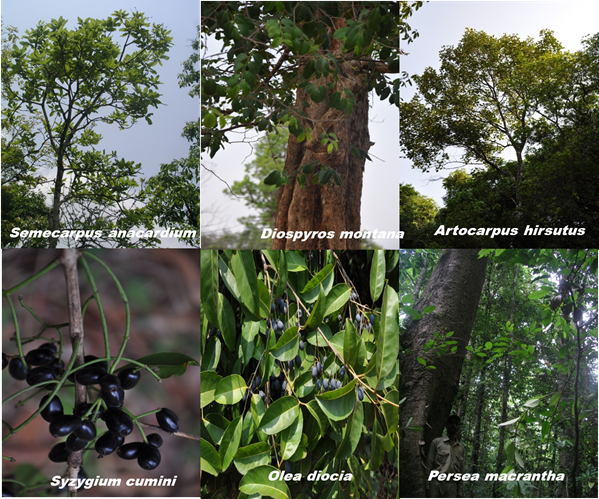
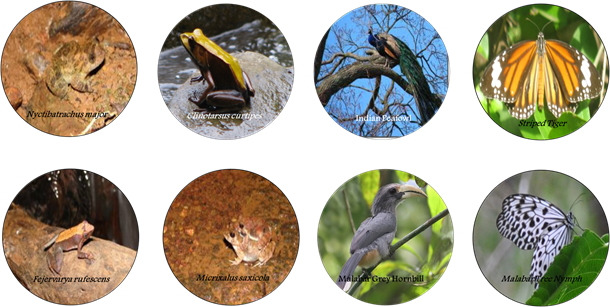
Figure 1 (b, c): Flora and Faunal diversity of Kali River Basin.
|
|
Dr. T.V. Ramachandra
Centre for Sustainable Technologies, Centre for infrastructure, Sustainable Transportation and Urban Planning (CiSTUP), Energy & Wetlands Research Group, Centre for Ecological Sciences, Indian Institute of Science, Bangalore – 560 012, INDIA.
E-mail : tvr@iisc.ac.in
Tel: 91-080-22933099/23600985,
Fax: 91-080-23601428/23600085
Web: http://ces.iisc.ac.in/energy
Bharath SetturuEnergy & Wetlands Research Group, Centre for Ecological Sciences, Indian Institute of Science, Bangalore – 560 012, INDIA.
E-mail: setturb@iisc.ac.in
Subash Chandran M DEnergy & Wetlands Research Group, Centre for Ecological Sciences, Indian Institute of Science, Bangalore – 560 012, INDIA.
E-mail: subhashc@iisc.ac.in
Rao G REnergy & Wetlands Research Group, Centre for Ecological Sciences, Indian Institute of Science, Bangalore – 560 012, INDIA.
E-mail: raogr@iisc.ac.in
Vishnu D Mukri
Energy & Wetlands Research Group, Centre for Ecological Sciences, Indian Institute of Science, Bangalore – 560 012, INDIA.
Joshi N VEnergy & Wetlands Research Group, Centre for Ecological Sciences, Indian Institute of Science, Bangalore – 560 012, INDIA.
E-mail: nvjoshi@iisc.ac.in
Citation: Ramachandra T V, Bharath Setturu, Subash Chandran M D, Rao G R, Vishnu D. Mukri, Joshi N V. 2017. Ecologically Sensitive Regions in the Kali River Basin, Karnataka: Delineation based on Ecological Principles and People’s Livelihood, ENVIS Technical Report 125, Sahyadri Conservation Series 68, Energy & Wetlands Research Group, CES, Indian Institute of Science, Bangalore 560012
| Contact Address : |
| |
Dr. T.V. Ramachandra
Energy & Wetlands Research Group,
Centre for Ecological Sciences, TE 15, New Biology Building, Third Floor, E Wing, [Near D Gate], Indian Institute of Science, Bangalore – 560 012, INDIA.
Tel : 91-80-22933099 / 22933503-extn 107
Fax : 91-80-23601428 / 23600085 / 23600683 [CES-TVR]
E-mail : cestvr@ces.iisc.ac.in, energy@ces.iisc.ac.in,
Web : http://wgbis.ces.iisc.ac.in/energy |
|