|
||||
|
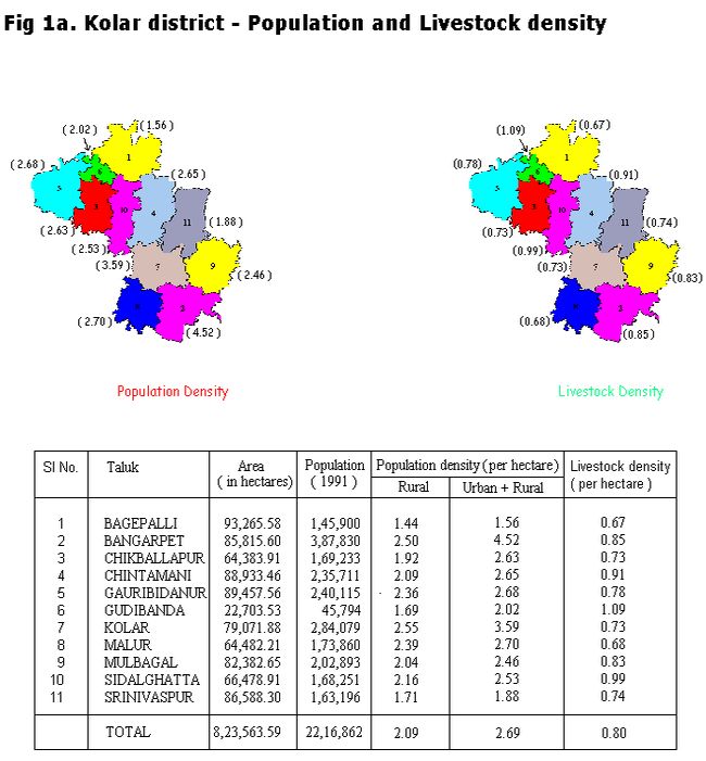
Study Area: Kolar District The Kolar District is located in the southern plains region of the Karnataka State, India. It lies between 77o 21' to 78o 35' east longitude and 12o 46' to 13o 58' north latitude and extends over an area of 8,225 sq.kms. The population was 22.17 lakhs in 1991 (as per census report). For administrative purposes the District has been divided into 11 Taluks. There are 15 towns and 3,325 inhabited villages in the District. Kolar belongs to the semi arid zone of Karnataka. In the semi arid zone apart from the year to year fluctuations in the total seasonal rainfall, there are also large variations in the time of commencement of rainfall adequate for sowing as well as in the distribution of drought periods within the crop growing season. Kolar district depends upon the distribution of rainfall during the southwest and northeast monsoon seasons. Out of about 280 thousand hectares of land under cultivation 35% is under well and tank irrigations. There are about 951 big tanks and 2934 small tanks in the district. The average population density of the district is 2.09 persons/hect (rural) and 2.69 persons/hect (rural+urban). The population density ranges from 1.44 (Bagepalli), 1.69 (Gudibanda), 1.70 (Srinivaspura) to the maximum of 2.55 (Kolar). While, the population density in taluks lies within this range - Bangarapet (2.52), Malur (2.38), Gauribidanur (2.36), Sidlaghatta (2.16), Chintamani (2.10), Mulbagal (2.04), Chikkaballapur (1.92). Fig 1a, depicts talukwise population and livestock densities.
|
||||