|
Urbanisation is a form of metropolitan growth that is a response to often bewildering sets of economic, social, and political forces and to the physical geography of an area. This could be planned (like townships, etc.) or unplanned (organic). Many organic cities are now undergoing redevlopment for economic purposes with new roads, infrastructure improvements, etc. It results in the increase in population in proportion to the region's rural population. This phenomenona is very rapid in India with urban population growing at around 2.3 percent per annum. The 20th century is witnessing "the rapid urbanisation of the world’s population", as the global proportion of urban population rose dramatically from 13% (220 million) in 1900, to 29% (732 million) in 1950, to 49% (3.2 billion) in 2005 and is projected to rise to 60% (4.9 billion) by 2030 (World Urbanisation Prospects, 2005). An increased urban population and growth in urban areas is inadvertent with population growth and migration. There are 35 urban agglomerations/cities having a population of more than one million in India (in 2001). Of the 4000 plus urban agglomerations, about 38 percent reside in just 35 urban areas, thus indicating the magnitude of urbanisation. Overall rise in population of urban poor or increase in travel times owing to congestion in road networks are indicators of the performance of planning in assessing and catering to the demand and lack of good urban governance. Thus the administration at all levels: local bodies, state government and national government are facing the brunt of rapid urban growth. It is imperative for planning and governance to facilitate, augment and service the requisite infrastructure over time systematically. This requires an understanding of pattern of urbanisation dynamics with causal factors. Traditional urbanisation exhibits a concentration of human activities and settlements around the regions of economic activities. With respect to the role of technology in urbanisation, Berry (1990) has illustrated a new linkage between transport infrastructure development cycles and spurts in urbanisation. Urban infrastructure development is unlikely to keep pace with urban population growth. Both local environmental impacts, such as deterioration of water quality in streams and an increased potential for harbouring disease vectors, and offsite land cover changes, such as the loss of woodland and forest to meet urban fuel wood demands, are likely to occur (Douglas, 1994). The direct implication of such urbanisation is the change in land use and land cover of the region. Urban ecosystems are the consequence of the intrinsic nature of humans as social beings to live together (Sudhira, et al., 2003). The process of urbanisation contributed by infrastructure initiatives and consequent population growth and migration results in the growth of villages into towns, towns into cities and cities into metros. However, in such a phenomenon for ecologically feasible development, planning requires an understanding of the growth dynamics. Nevertheless, in most cases there are lot of inadequacies to ascertain the nature of uncontrolled progression of urban sprawls.
Urban sprawl refers to the dispersed development along highways or surrounding the city and in rural countryside with implications such as loss of agricultural land, open space and ecologically sensitive habitats. Sprawl is thus a pattern and pace of land use in which the rate of land consumed for urban purposes exceeds the rate of population growth resulting in an inefficient and consumptive use of land and its associated resources. This phenomenon is characterized by an unplanned and uneven pattern of growth, driven by multitude of processes evident from lack of basic amenities. Urban sprawl is thus a term often used variously to mean the gluttonous use of land, uninterrupted monotonous development, leapfrog discontinuous development and inefficient use of land that are influenced by a myriad of factors, including land features, infrastructure, policies, and individual characteristics. This is characterised by low levels of some combination of eight distinct dimensions such as density, continuity, concentration, clustering, centrality, nuclearity, mixed uses and proximity (Elena and Nancy, 2004; Galster, et al., 2001; Peiser, 2001; Ramachandra, et al., 2004). Basic spatial forms of sprawl are described by Low-density sprawl, Ribbon and Leapfrog development. The consumptive use of land for urban purposes along the margins of existing metropolitan area supported by piecemeal extensions of basic urban infrastructures such as water, sewer, power and roads characterizes low-density sprawl. The development that follows major transportation corridors outward from urban cores with lands adjacent to corridors are developed, but those without direct access remain in rural uses/covers characterizes ribbon sprawl. Over time these nearby raw lands may be converted to urban uses as land values increase and infrastructure is extended perpendicularly from the major roads and lines. Provision of certain infrastructure facilities like new roads and highways, fuel such sprawls that ultimately result in inefficient and drastic change in land use affecting the ecosystem. Compared to these, leapfrog development is a discontinuous pattern of urbanisation, with patches of developed lands that are widely separated from each other and from the boundaries. This form of development would be expensive for providing urban services such as treated drinking water supply, provision of electricity, waste and sewerage (http://chesapeake.towson.edu/landscape/urbansprawl).
Consequences of urbanisation and urban sprawl: Urbanisation and urban sprawl have posed serious challenges to the decision makers in the city planning and management process involving plethora of issues like infrastructure development, traffic congestion, and basic amenities (electricity, water, and sanitation), etc. (Vijay Kulkarni and Ramachandra, 2006). Apart from this, major implications of urbanisation are:
- Floods: Common consequences of urban development are increased peak discharge and frequency of floods as land is converted from fields or woodlands to roads and parking lots, it loses its ability to absorb rainfall. Conversion of water bodies to residential layouts has compounded the problem by removing the interconnectivities in an undulating terrain.
- Heat island: Surface and atmospheric temperatures are increased by anthropogenic heat discharge due to energy consumption, increased land surface coverage by artificial materials having high heat capacities and conductivities, and the associated decreases in vegetation and water pervious surfaces, which reduce surface temperature through evapotranspiration.
- Loss of aquatic ecosystems: Urbanisation has telling influences on the natural resources evident from the sharp decline in number of water bodies and also from depleting groundwater table. Figure 1 illustrates the loss of aquatic ecosystems (70% decline during 1973-2007 in the Bangalore city limits) and vegetation with the increase in built up area (466% during 1973-2007).
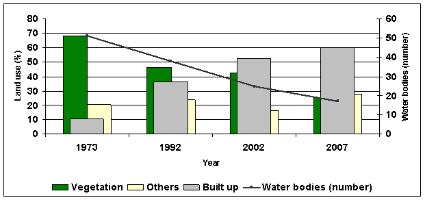
Figure 1: Temporal changes in built up and its impact on vegetation and water bodies
|