


* Coordinator, Energy & Wetlands Research Group, Centre for Ecological Sciences, Indian Institute of Science, Bangalore, India.
E-mail : cestvr@ces.iisc.ac.in
** Research Scholar, Centre for Sustainable Technologies, Indian Institute ofScience, Bangalore, India. E-mail : uttam@ces.iisc.ac.in
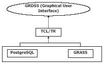
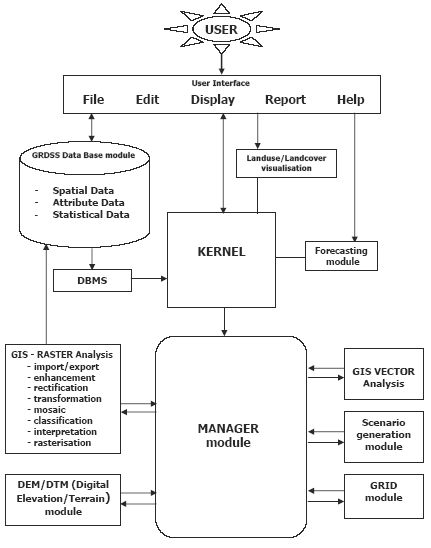 India.GRDSS is based on GRASS that aids in decisions related to land use and land cover changes. This spatial decision support system aids the policy makers and planners to visualize the decision outcome.GRASS and GRDSS are freeware (and work on Linux), which could be widely implemented with less economical implications. LISS III MSS
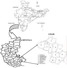
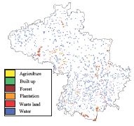
data of Kolar district was classified using Gaussian maximum likelihood classifier with an overall accuracy of 94.67%. This analysis shows that wasteland constitutes 38.88%, indicating a lack of holistic approaches in land use planning that has led to the loss of top productive soil due to removal of vegetation cover during the last four decades leading to unproductive waste lands.
India.GRDSS is based on GRASS that aids in decisions related to land use and land cover changes. This spatial decision support system aids the policy makers and planners to visualize the decision outcome.GRASS and GRDSS are freeware (and work on Linux), which could be widely implemented with less economical implications. LISS III MSS
data of Kolar district was classified using Gaussian maximum likelihood classifier with an overall accuracy of 94.67%. This analysis shows that wasteland constitutes 38.88%, indicating a lack of holistic approaches in land use planning that has led to the loss of top productive soil due to removal of vegetation cover during the last four decades leading to unproductive waste lands.KeyWords : Spatial Decision Support System, GRDSS, Remote Sensing, GIS, Spatial analysis, Land Use, Natural Resource Management