Introduction |
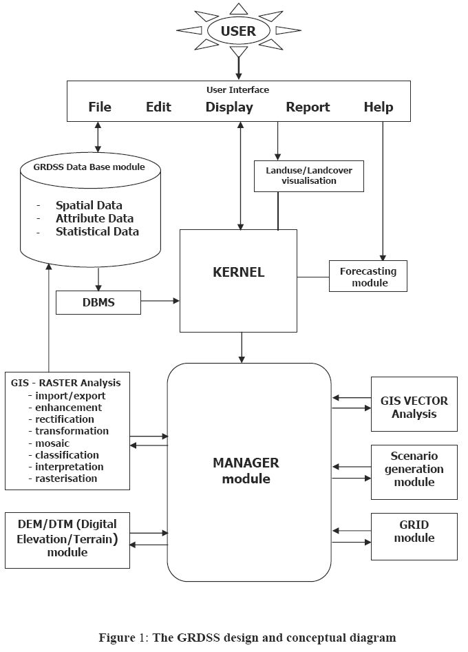
Spatial Decision Support System (SDSS) aids decision-makers and planners to capture, store, process, display, organize, prioritize and visualize the decisions with spatial and temporal dimensions. This interactive, computer-based information system is designed to support users in achieving effective decision making by solving unstructured or semi-structured spatial problems (Jayashankar, R. 1991). The focus of SDSS is on providing flexible and adaptable tools for policy analysis and quick response rather than providing models to answer structured problems (Parker and Ul-Ataibi, 1986). Modeling tools are also a part of SDSS, which comprises three component subsystems; the database management system for managing integrated database to drive modules, the model management for creating, cataloguing, editing, inter-relating models by links through the databases and the dialogue management that is guided by various methodological considerations, such as scenario approach, integrated environment planning, flexibility and user friendliness (Ramachandra, et al., 2001). The conceptual design of GRDSS is shown in figure 1. GRDSS is based on GRASS (Geographic Resources Analysis Support System) and aids in decisions related to land use and land cover changes. This helps in sustainable resources management by analyzing the likely impacts associated with the decision related to land use changes.
GRASS released under General Public License (GPL) is an open source GIS under Linux platform (http://www.grass.itc.it/). It has vector analysis, image processing, data management, statistical analysis and spatial modeling capabilities along with graphics production functionality that helps in visualizing the data. It can also operate on various platforms through a Graphical User Interface (GUI) and shell in X-Windows. GRASS has evolved into a powerful utility with a wide range of applications during the last decade (http://ces.iisc.ac.in/grass). It contains programs (in C) for displaying maps and images, managing existing data, manipulating raster and vector data, etc. GRASS uses both intuitive windows interface and also command line syntax for ease of operations.
A remote sensing and GIS based decision support system for local land use officials developed by Arnold C.L. et al., (2000) shows that decision support system when integrated with applications and outreach form, remote sensing information becomes a powerful force in assisting local officials to plan better the growth of their communities. A simple DSS for Town-Level Land-Use decisions could work well over municipalities in Connecticut, USA. The project analyses and information were incorporated into several regional and state plans. A watershed framework for Local Land-Use planning with focus on Eightmile River Watershed (having 100 square kilometres in area and involves three towns) was made to demonstrate the utility of geospatial data and analysis in assisting local land-use decision makers. Based on the above two case studies, a framework to develop specific metrics and tools with emphasis on suburban/urban sprawl and its impacts on water and forest resources was made. These were applied by local use decision makers and officials to community planning.
A geospatial semi-expert system for landscape analysis developed by Jeganathan et al., (1999) attempts to analyse and prioritise different ecosystems for conservation by using the existing knowledge and assessing the disturbance impacts/regimes by way of investigating and inventorying biological richness of the areas. A mask of 0.5 x 0.5 km area was chosen and all the landscape parameters were calculated and integrated to yield the final models. The results for Meghalaya, one of the north-eastern states of India, proved successful in putting the thematics expert in driving seat and it was concluded that the presence of semi-expert system has made the end users and resources managers to operationalize their views, by integrating GIS software capabilities.
Land cover refers to the physical characteristics of earth's surface, captured in the distribution of vegetation, water, soil and other physical features of the land, including those created solely by human activities such as settlements, etc. Landuse refers to the way land has been used by humans and their habitat, usually with accent on the functional role of land for economic activities. It is the intended employment of and management strategy placed on and cover type by human agents, or and managers (Xavier, B., and Gerard, S., 1997). Land use categories include built up (buildings, roads, industries, etc.), agricultural (crop lands, orchards), plantation, forest (areas with tree-crown areal density), wetland (water bodies, marshy areas), barren land (dry salt flats) etc.
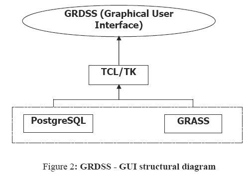
Land cover and Land use analysis is done to understand the dynamics of landuse changes and the drivers responsible for changes. These changes often lead to serious ecological and environmental impacts. More over, insights in Landuse/Landcover are needed to identify the likely points where human communities can intervene to change the trajectories of land use (and thereby environmental change) according to changing needs and values (Fresco, et al. 1996).Land use and other natural resource management including environmental impact assessment can be visualised by GRASS GIS. Since GRASS is in command line syntax, a graphical user interface was developed to aid users with the menu driven functions in a graphical format. The structural diagram of GRDSS GUI developed in the scripting language TCL/TK is shown in figure 2.
GRDSS can be invoked within GRASS with the "tcltkgrass&" command and the interface allows to use the GRASS modules with a mouse. GRDSS uses postgreSQL (a freeware) as a database for data storage, data retrieval, query and manipulation of both spatial and attribute information. PostgreSQL has comprehensive SQL support, referential integrity, MVCC or Multi-Version Concurrency Control to avoid unnecessary locking that increases the reliability of the database by logging changes before they are written to the database.