


Uttam Kumar a,b, Norman Kerle c, and Ramachandra T V a,b *,
Senior Member, IEEE
(a) Energy Research Group, Centre for Ecological Sciences, Indian Institute of Science, Bangalore-560012.
(b) Centre for Sustainable Technologies, Indian Institute of Science, Bangalore-560012, India.
(c) International Institute for Geo-Information Science and Earth Observation (ITC), P.O. Box 6, 7500 AA Enschede, The Netherlands. E-mail: kerle@itc.nl
* Corresponding author: cestvr@ces.iisc.ac.in
![]()
Constrained Linear Spectral Unmixing Technique for Regional Land Cover Mapping Using MODIS Data |
|
 |
Book - Innovations and Advanced Techniques in Systems, Computing Sciences and Software Engineering |
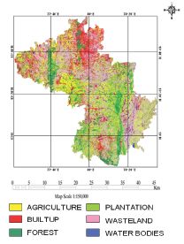
AbstractOver the last few decades, there has been a significant land cover (LC) change across the globe due to the increasing demand of the burgeoning population and urban sprawl. In order to take account of the change, there is a need for accurate and up-to-date LC maps. Mapping and monitoring of LC in India is being carried out at national level using multi-temporal IRS AWiFS data. Multispectral data such as IKONOS, Landsat-TM/ETM+, IRS-1C/D LISS-III/IV, AWiFS and SPOT-5, etc. have adequate spatial resolution (~ 1m to 56m) for LC mapping to generate 1:50,000 maps. However, for developing countries and those with large geographical extent, seasonal LC mapping is prohibitive with data from commercial sensors of limited spatial coverage. Superspectral data from the MODIS sensor are freely available, have better temporal (8 day composites) and spectral information. MODIS pixels typically contain a mixture of various LC types (due to coarse spatial resolution of 250, 500 and 1000 m), especially in more fragmented landscapes. In this context, linear spectral unmixing would be useful for mapping patchy land covers, such as those that characterise much of the Indian subcontinent. This work evaluates the existing unmixing technique for LC mapping using MODIS data, using end-members that are extracted through Pixel Purity Index (PPI), Scatter plot and N-dimensional visualisation. The abundance maps were generated for agriculture, built up, forest, plantations, waste land/others and water bodies. The assessment of the results using ground truth and a LISS-III classified map shows 86% overall accuracy, suggesting the potential for broad-scale applicability of the technique with superspectral data for natural resource planning and inventory applications.
Index TermsRemote sensing, digital image processing, superspectral, Geographic Information System.
![]()
International Joint Conferences on Computer, Information, and Systems Sciences, and Engineering (CIS2E 07), December 3 - 12, 2007, Technically Co-Sponsored by: Institute of Electrical & Electronics Engineers (IEEE), University of Bridgeport