The Uttara Kannada district situated along the west coast of South India covers an area of 10, 276 sq.km. The hill chain of Western Ghats, which runs parallel to the west coast, from river Tapti in north to Kanyakumari in south, passes through this district and divides it into two zones: the narrow coastal strip and the wider upland country along the Ghats at a general elevation of approx. 675m. The length of Uttara Kannada coastline is about 144 kms. The coastal Uttara Kannada consists of five taluks namely Karwar, Ankola, Kumta, Honnavar and Bhatkal from north to south and has a total area of 3300 sq.km. Four main rivers – Aghanashini, Sharavathi, Kali and Bedthi which originate in the Western Ghats, traverse through the district and join the Arabian sea.
The Karwar coast lying in the northern limits of Uttara Kannada coast is unique in many respects. The coastline in this division is rugged and the coast is predominantly rocky with relatively short stretches of sandy beaches and capes projecting into the sea. Among the four rivers joining the sea in Uttara Kannada coast, the northernmost river Kali drains into the Karwar Bay at this northern boundary. The continental shelf extends to a width of about 96 kms off Karwar. Sediment gradation at sea bottom of this region is from sandy near inshore to muddy farther away (Bhat et al, 1988). Annigeri (1968) for the first time carried out a study highlighting the seasonal distribution of temperature, salinity, oxygen, phosphates, nitrates and silicates at surface, middle and bottom levels during 1964-66. Sudarshana (1983) while investigating the benthic ecology of Karwar Bay observed that the depth varied from 2 to 15 meters. While investigating plankton distribution, Naik (1986) noted a range in water temperature of 28.77 – 29.87oC in different localities of Karwar Bay.
Noble (1962) recorded the various parameters such as temperature, salinity, pH, dissolved oxygen, dissolved inorganic phosphates, nitrites and silicates of the sea water along the North Kanara coast observed from January 1960 to December 1964. The samples were collected at surface level during morning time from four stations namely Karwar, Chendia, Ankola and Kumta. The temperature, oxygen, phosphates and nitrites have been observed to be bimodal in their seasonal distribution with primary and secondary peaks. The sea-water off the North Kanara coast was found to be rich in nutrient salts. The rainfall, river influx and drainage from land were found to be greatly affecting the coastal waters.
Annigeri (1972) studied the hydrological conditions of the inshore region of Karwar during the years 1965 – 1967 by collecting the inshore samples from surface, 10 m and bottom (15-31 m). The results highlighted a distinct demarcation in the distribution of physic-chemical properties. The values of dissolved oxygen reached maximum in the sub-surface layers while the distribution of nutrient salts was found to be concentrated at the bottom. The saturation and super-saturation values were frequently observed at 10 m and 15-31 m than that at surface, indicating the zone of maximum photosynthesis below the surface waters.
Annigeri (1979) recorded the observations on the hydrographical features of the coastal waters of North Kanara during 1965-1966 which indicated that the surface temperature along the coast showed seasonal annual bimodal oscillation with the average temperature varying from 25oC to 31oC. An abrupt fall was recorded in the salinity levels during the southwest monsoon period which could be attributed to the effect of rainfall and surface run-off during this period. The average pH values varied between 7.9 – 8.2. The inorganic phosphorus showed single annual peak while the dissolved oxygen showed two peaks and two falls in a year. The distribution pattern of nitrite values was very random and showed no annual rhythm. The silicate concentration was high during the period June to September and low values were registered in the pre-monsoon months.
Subhash Chandran (1984)carried out a study for management of ecosystems for optimization of biomass production and to understand the role of plant formations in conserving the general ecology of coastal region of Uttara Kannada district. The quadrate method was employed to study the forests of Kumta taluk and parts of Sirsi and Siddapur taluk and presence of Tropical Wet Evergreen forests was found in the coastal Uttara Kannada region. These forests are very old and highly productive encompassing a wonderful biodiversity. The lowlands in the coastal area were found to be possessing mixed vegetation ranging from Degraded Evergreen Forests to Semi-Evergreen, Moist Deciduous forests. Extensive coastal areas were also found to be endowed with rocky hills and plateaus with sparse scrubby vegetation. Due to ruthless exploitation of the evergreen forests in this region by local people and plunderers these forests are facing degradation, desiccation and danger of species extinction. Hence, the author suggests that Upgradation of the degraded forests can be brought about by reforestation of the denuded coastal hills and plateaus with fast growing evergreen species, which provides a canopy to shade the exposed habitat and litter to build the soil. A combination of Acacia auriculiformis, Casuarina, Mimusops elengi, Ochrocarpus, Carallia, Syzygium cumini, Memecylon umbellatum, Mangifera, etc all of which can survive on the lateritic habitat, may be included in reforestation.
The wave pattern of Karwar inshore region was investigated by Veerayya and Pankajakshan (1988) wherein they observed that certain stretches of open ocean beaches located on either side of Kali River and the headland bay beaches south of Karwar head experienced relatively higher wave heights for IW and SWS waves, the latter being more prone to higher wave heights for waves from SW. The Karwar port as well as a greater stretch of the Karwar-Kodibag beach being on the lee side of Karwar head, has been observed to be receiving good shelter for WSW and SW waves and only the extreme northern part of Karwar beach is affected by these waves.
Mislankar and Antao (1992) analyzed the textural parameters for 48 surface sediment samples of Sadashivagad and Karwar beaches in Central West Coast of India. The grain size data revealed that the Sadashivagad beach composed of medium to fine sand while the Karwar beach was composed of coarse to fine sand. The frequency distribution curve for Sadashivagad beach sediments was found to be weekly bimodal to unimodal from the river mouth to north while the Karwar beach sediments curve showed strongly bimodal nature. The symmetrical skewed sediment distribution patterns on the Sadashivagad beach indicated a slow rate of deposition whereas negatively to positively skewed sediment distribution pattern on the Karwar beach indicated strong winnowing and deposition. The gradual decrease in mean grain size from north to south in the Karwar beach indicated the direction of movement of sediments towards south and south west of the Kali River. Though both these beaches are adjacent and are acted by similar oceanographic condition, the difference in their textural parameters was mostly due to the difference in the sediment dispersion brought by Kali River.
Hanamgond and Chavadi (1993) carried out a study to understand the processes over different temporal scales in a sheltered type of beach with a special reference to onshore and offshore sediment movements using volume changes and Empirical Orthogonal Function (EOF) analysis. For this three stations were selected on the Aligade beach in Uttara Kannada in such a way so as to represent the entire beach and were monitored regularly. The analysis of the beach profiles revealed that the erosion or deposition on the beach varied between successive seasons or months and from station to station and the net changes were governed mainly by waves, long-shore currents and physical setting of the beach. The volume computations indicated that the beach at all three locations experienced accretion through episodic as well as continuous cycles of erosion/accretion giving rise to a net gain of 34.6 m3 m-1 sediment during November, 1988 to February, 1990. The spatial function revealed a similar nature for all three beach stations whereas the temporal functions revealed the beach experienced maximum erosion during the southeast monsoon and the northwest monsoon with maximum accretion during pre-monsoon season.
The analysis of deep water wave characteristics during the monsoon period was measured by Mandal et al (1993) which showed that the waves in general seemed to be oriented towards the coastal region. The wave heights were found to be relatively high during the study period. In most of the study case, single peaked wave spectra were observed which indicated that predominant waves were generated wind having one main wave train approaching towards the coast.
Bannur (1994)studied the coastal environments using remote sensing techniques and morphology of the beaches of Uttara Kannada district and found that the coastal plains were only few meters above sea level, covering an area of 533 sq.km. due to the descending Western Ghats. The coast exhibited features of both submergence and emergence indicating a compound shoreline and gave an irregular appearance due to rocky head lands which were made up of granitic gneiss with lateritic cover. Majority of the beaches of Uttara Kannada district were composed of medium to fine grained sediments which were mainly composed of quartz with small amount of heavy mineral assemblages. The study also revealed that the beach changes were always in the state of continuous transformations and the erosional and depositional process were manifestations of interplay between various forces induced by variables like wind, waves fluctuations, ground water level, etc.
Bhat (1998)studied the morphology of the beaches and the texture and heavy metals of beach sediments between Gokarna and Kumta beaches in Uttara Kannada district of Karnataka. For studying the spatial and temporal variabitlity, 8 points were fixed on Gangavali - Gokarna beach, 7 points on Aghanashini - Kumta beach, 3 at Kudle beach and 2 at Om beach and the variations in the beach geometry were monitored at monthly intervals. The sediments of all the four beaches viz. Gangavali-Gokarna, Aghanashini-Kumta, Kudle and Om were found to be falling in the fine sand class with the mean particle size ranging from 1.35-2.81, 1.76-2.785, 2.017-3.18 and 2.001-3.791 respectively. The changes observed in the beach morphology were found to be temporary and caused due to seasonal variations, thus reverting back to a stable form. The major heavy minerals recorded were magnetite, illemite, zircon, hornblende, hypersthene, tourmaline, garnet, kyanite, rutile without any significant distribution trend.
Balakrishna et al (2001) studied the the distribution of 238U, 234U, 232Th and 230Th in soils, water, suspended particulate matter (SPM) and bottom sediments in the Kali river basin around Kaiga, its estuarine region and the adjacent Arabian Sea near Karwar in Uttara Kannada district. The samples of the soil, water, SPM and bottom sediments were collected in pre-monsoon, monsoon and post monsoon seasons and were analyzed for the presence of U-Th series radionuclides. The 232Th/238U weight ratio and 230Th/238U activity ratio in the bottom sediments, SPM and soil samples were closely related indicating that both the isotopes of Th are preferentially transported in the solid phase. The mean 234U/238U activity ratio for the Kali estuary – nearshore zone and the adjacent Arabian Sea was found to be 1.16 + 0.02 which was comparable to that of other estuaries or coastal waters. The 232Th in the bottom sediments had a tendency to increase towards the estuarine and coastal areas, presumably due to deposition of heavy minerals and onshore transport of coastal sediments into the estuary. The dissolved U in the Kali River was found to be low when compared to the major Indian rivers as it flows through U-poor greywackes.
Bhat (2002)carried out a study focusing on description of landforms, beach sedimentary environments and land use-landcover categories of coastal and adjacent hinterlands of Karwar region in Uttara Kannada district of Karnataka state. The geomorphology was studied using the remote sensing techniques and the different coastal landforms identified in the area were coastal plain, beaches, coastal promontories, rocky coastlines, tidal flats, marsh lands, estuary, mangrove environments and offshore islands. The study of sediment textural properties revealed a prominent seasonal heterogeneity in the distribution of mean size of sediments along the Majali beach. The results of the study also indicated a prominent seasonal heterogeneity in the residual transport directions along beach scarp, beach face and swash zone on the Baitkol and Binaga beaches. It could be concluded from this study that the seasonal variations in oceanographic environment intrinsically resulted in variation of sediment size enforcing heterogeneity in residual transport directions of sediments in tropical environment of Karwar.
Naik et al (2005) studied the temporo-spatial variation in the texture of sediments collected from Binaga and Karwar Bay during November 1991 and November 1992. No significant variation in the sediment temperature between the study sites and among the seasons was observed. Both the study sites exhibited uniformity in alkaline range with more alkalinity being in the post-monsoon season. The three most abundant types of sediments found on the shelf of Karnataka coast are clayey silt, silty sand and sand.
Hanamgond and Mitra (2007) used the multi temporal satellite data for change detection, identification of beach ridges and analyzing the tectonic influence on the Karwar coast in Uttara Kannada district. For this they used the Landsat TM (1989), ETM+ (2000) and IRS 1C LISS III (2003) images spanning a period of 13 years and created the subsets of the study area for demarcating the lineaments, beach ridges, erosion and accretion using the remote sensing techniques. The erosion of land across the stretch of the coast was found to have drastically increased during 2000-2003 than during 1989-2000 which may be due to increased human interference along the coast owing to urbanization, harbor development, naval base establishment, desiltation, etc.

COASTAL RESOURCES IN UTTARA KANNADA
Karnataka on the west coast plays an important role in the fisheries development of India and has a prominent place in the country’s fisheries map (Kurup et al, 1987). The state has three coastal districts namely Uttara Kannada, Udupi and Dakshina Kannada. Many important west flowing rivers like Sharavathi, Aghanashini, Kali, Gangavali and Netravathi flow into the Arabian Sea and render the inshore areas rich in nutrients. The Uttara Kannada district being the largest coastal district of the state has four major rivers flowing into the Arabian Sea and has a rich coastal productivity which includes fishes, crabs, prawns, clams and mussels, oysters, etc. Fishing is the one of the most important occupation in the district mostly for the people living in coastal taluks and contributes significantly in the socio-economic development of the state.
Radhakrishnan (1958) recorded the observations on mackerel fishery, which is considered to be the mainstay of Karwar coast fishery activities, during the years 1954-56. He found that as compared to the total fish catch in the year 1951-52 (2,250 tonnes), the fish catch dwindled drastically to 951.2 and 508.3 tonnes in the years 1954-55 and 1955-56 respectively. The mackerel season for the year 1954-55 commenced late owing to prolonged rainy season while the mackerel fishery for the year 1955-56 season was complete failure throughout the Kanara coast except at Honnavar. The total numbers of Rampans operated at Karwar for 1954-55 and 1955-56 were 97 and 88 respectively. The wholesale and retail price of wet and unprocessed mackerel fishes was found to be fluctuating markedly from month to month during the mackerel season according to the law of supply and demand of the commodity. The results did not indicate any marked differences in the size-groups of mackerel caught at Karwar, Majali, Ankola and Kumta during the 1955-56 seasons.
Radhakrishnan (1962) studied the maturity and spawning details of Indian Mackerel, Rastrelliger canagurta (Cuv.) from January 1955 to December 1958. The minimum and maximum sizes of the fish recorded were 98 mm (in August, 1956) and 307 mm (in January, 1955). The period of spawning of this species in this region was found to be a prolonged one commencing from June-July. Generally towards the end of February, the percentage of larger size groups seemed to be higher and a progressive increase in size was noticed from March to August.
Ramamurthy (1965) recorded the observations on the plankton communities and their relation to the hydrological factors at four inshore stations along the North Kanara coast. The phyto and zooplankton composition and their seasonal fluctuations in the North Kanara coast were observed to be more or less similar to those of the Malabar Coast. The zooplankton production was found to be closely associated with the diatom production. The grazing effect of the herbivorous zooplankton appeared to be an important factor in regulating the plant crop. Overall, the south-west monsoon season and immediate post monsoon period were found to be the most productive period for the planktonnes.
In 1980, the annual marine fish production in Karnataka state was found to be 115, 322 tonnes which represented 9.23% of the total fish landed in India (Kusuma et al, 1985). Kusuma et al (1985) also highlighted the fishery resources of Kali estuary and the overall inshore fish production of the Karwar coast in Uttara Kannada district. The survey revealed the presence of 46 different fish species belonging to 25 families in the Kali estuary. The overall inshore fish landings during the year 1979-80 were recorded to be 46, 147 tonnes valuing at Rs. 61.8 million which highlighted the importance of fishery in this district.
Neelakantan et al (1985) carried out a study on the mussel and clam resources of the central West-coast of Uttara Kannada district. The edible mussels found in India are Perna viridis (green mussel) and Perna indica (brown mussel) of which the green mussels were found to be widely distributed in and around Karwar region. The mussel fishery in Uttara Kannada was termed to be of ancillary nature with most of the mussels being hand-picked or removed with the help of knife. The clams were found to be the major component of shell fish resources of Kali estuary with the most important genera being Meretrix, Paphia and Villorita. An increasing trend was observed in the molluscan production from the Karwar coast from 1971 to 1979. The minimum production of 86 tonnes valuing at Rs. 41,000 was recorded during 1971-72 while the maximum production of 726.9 tonnes valuing at Rs. 341,643 was recorded for the year 1978-79.
Penaeus (Fenneropenaeus) mergiiien, also commonly known as banana prawn is one of the commercially important penaeid prawns occurring in Indian waters. This species inhabits the coastal waters upto a depth of about 55 meters and is more abundant in shallower areas where the sea bottom is muddy and sandy. On the west coast of India this species is caught in appreciable quantities from North Kanara, Goa and Ratnagiri coasts. It forms 1.4% of the total prawn landings by shrimp trawlers at Karwar. The observations on the seasonal fishery of this species along the inshore waters of Karnataka coast during 1981-84 reveals sporadicity in the occurrence and schooling behavior of the banana prawn (Nandakumar, 1988).
Kusuma and Neelakantan (1992) analyzed the status and magnitude of exploited sciaenid fishery resources along the Uttara Kannada coast with the help of secondary data obtained from CMFRI and State Fisheries Department, Govt. of Karnataka. The total landings of fish in the district were found to be 47,719.2 tonnes during 1986-87 which was valued at Rs. 171.8 million. The annual sciaenid landings along the Uttara Kannada coast 0.02 to 7.53% of the annual total fish catch between 1973-74 and 1986-87. The highest landings of sciaenid were recorded in 1983-84 when 2,665.8 tonnes of fish valued at Rs. 80,60,600 were caught.
Syda Rao et al (1989) studied the distribution, abundance and exploitation of clam resources in the estuaries of Karnataka during the year 1984. Out of the 14 estuaries surveyed in the study, 8 estuaries were found to be having stock of live clams and the Aghanashini, Kalinadi and Mulki estuaries were found to be having high production potential of clams. The different clam species encountered during the study were Meretrix meretrix, M. casta, Katelysia opima, Paphia malabarica and Villorita cyprlnoides. The department of Mines and Geology, Govt, of Karnataka, had estimated the shell deposit reserve of Kalinadi estuary to be about 1,16,090 tonnes (Venkatkumaran and Bhat 1978) while in this study, the annual rate of shell deposit exploitation was found to be about 24,500 tonnes. The estimated shell deposits for the Aghanashini estuary were recorded as 9,27,500 tonnes (Venkatkumaran and Bhat 1978) and the annual exploitation rate of clams from this estuary was estimated to be 7600 tonnes. The annual estimated reserve of clam shells in Sharavathi estuary was reported to be 1,16,090tonnes with annual production of 75 to 100 tonnes of shells (Venkatkumaran and Bhat 1978).
The oil sardine, Sardinella longiceps Val. is a major pelagic fishery of Karnataka state which shows strong decadal andannual variations. The all India landings of oil sardine decreased drastically from 279,000 t in 1989 to a mere 47,000 t in 1994 (Ganga, 2000). In 1980’s small pelagics such as oil sardine, mackerel and anchovies made up nearly 50% of the catch, in 1990’s, the oil sardine dropped from 33% to 7% and resources such as nemipterids, cephalopods, flatfishes, ribbon fishes and carangids mostly exploited by trawler units increased in relative terms (Mohamed et al., 1998). Earlier Annigeri (1971) had estimated the mortality rate of oil sardine fishery at Karwar in terms of the standard fishing unit namely the shore seine. The study showed that the total instantaneous mortality rate (Z) was found to be in the range of 1.57-3.7 while the fishing mortality (F) and natural mortality (M) values were found to be 0.12-2.25 and 1.45 respectively.
The Cladocerans are planktonic crustaceans which play a considerably important role in the economy of the sea due to their relation to pelagic fisheries and are also believed to play an important role in phosphorous regeneration (Barlow and Bishop, 1965). The cladocerans reproduce parthenogenetically, act as filter feeders and their association to phytoplanktonnes especially diatoms is fairly well known (Madhupratap, 1981). Naik et al (2006) investigated the occurrence of cladocerans in the estuarine and inshore waters of Karwar and recorded the presence of two species of cladocerons – Penilia avirostris and Evadne tergestina. The maximum density of cladocerons was observed during south west monsoon period when the salinity level was low as compared to pre-monsoon season when salinity level was more and cladoceron density was less.
Naomi (1986) studied the composition and fluctuations of zooplankton communities of Karwar waters based on the observations between January 1980 and December 1981 in comparison with the fisheries. The results revealed that in the South-West monsoon period, when the salinity, temperature and abundance of phytoplanktonnes decreases, only minor amount of fishery takes place which is mostly devoid of mackerels. However, in post-monsoon season, as the temperature and salinity levels gradually ascend, there is a manifold increase in the numerical abundance of zooplanktonnes, resulting in sudden improvement of fishery, particularly with large catches of mackerels. During the approach of summer season, with the increasing temperatures and minimal variations in salinity levels, the copepods constitute a greater part of the zooplankton population which leads to high fish gain and multispecies catch composition.
Ganga (2000) carried out a detailed study on the oil sardine fishery at Karwar during the period 1990-98 using the length frequency data collected from the purse seine landings at Karwar Fisheries Harbour. Annual variations were observed in the fishery with extremely poor catches during the period of 1993-1995. A considerable increase was recorded in the effort expended by purse seine units operated along the Karwar coast during 1996-98 compared to that in the 1990-92 period, and exploitation ratio(U) was 0.51 and 0.78 respectively during the two periods. In this study the values of total instantaneous mortality rate (Z), fishing mortality (F) and natural mortality (M) were found to be 2.7, 1.47 and 1.43 respectively.
Naik et al (2006) carried out a study to assess the trend and correlation between nutrients and primary production of the Karwar Bay for a period of one year. The study area was found to be quite turbid almost all times with the eutrophic zone never exceeding 2.2 m. The rate of production in all the stations studied was found to be maximum during August/September. The correlation between the nutrients (phosphate and nitrate) and the production was low indicating an instantaneous concentration of these nutrients salts. The estimated annual primary production potential of the studied area was found to be 315 tC.
ESTUARIES OF UTTARA KANNADA
An estuary is a type of wetland which can be defined as ‘the area where rivers meet sea and the salinity is intermediate between salt and freshwater’ (Scott, 1989). The interaction between the biotic and abiotic components of this ecosystem express themselves as functions, including nutrient cycling and exchange of water between the surface and groundwater and the surface and the atmosphere (Barbier et al, 1997). Forming a dynamic zone of convergence between land and sea, the coastal regions of the earth serve as unique geological, ecological and biological domains of vital importance to a vast array of terrestrial and aquatic life (Wilson et al., 2005). Although influenced by the tides estuaries are protected from the ocean waves, winds and storms by reefs , barrier islands and land, mud or sand that define an estuaries seaward boundary (Madhyastha et al., 2002). More than 200 rivers are seen flowing towards the west coast of India and evolve as estuaries before joining the Arabian Sea (Ansari, 1977).
Uttara Kannada district has a number of seasonal small and medium sized rivers, most of which are westward flowing. The rivers namely Kalinadi, Gangavali (Bedthi), Aghanashini, Sharavathi, and Venkatapura arise in the Western Ghats and flow westwards through the district to finally join the Arabian Sea. The estuaries of these five rivers (Figure 2) are highly productive and support a large number of local livelihoods. The location and description of these estuaries is provided herewith:
Kali estuary - Kali estuary situated at Lat 14.8160 N to 14.9170 N and Long 74.1250 E to 74.2670 Ein the Karwar taluk of Uttara Kannada district of central west coast in the Karnataka State. Kali river originate near the Diggi village in the Supa taluk with a total length of 184 Km meets the Arabian sea,3 Km north of Karwar and forming an estuarine expanse of 3240 ha in area. The Kali estuary is surrounded by a variety of ecosystems such as mangrove swamps, mudflats, creeks and backwaters. The estuary is surrounded by 23 villages and one municipality.
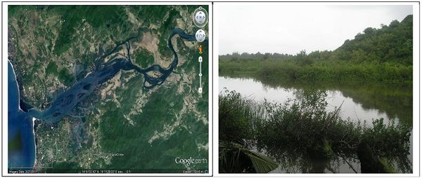
Figure 2: Kali estuary in Karwar taluk, Uttara Kannada district
Gangavali Estuary - Gangavali or Bedthi River is formed by the confluence of two streams at Khalghati in Dharward district and flows 25 Km westwards and reaches the Uttara Kannada district. After a fairly straight south western flow it joins Arabian Sea at Manjuguni village of Ankola taluk and forming an estuarine habitat of about 700 ha area (Lat 14.5860 N to 14.6180 N and Long 74.2780 E to 74.3850 E). The estuarine habitat support 43.20 ha mangrove vegetation and it is surrounded by 15 villages.
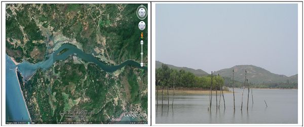
Figure 3: Gangavali estuary in Ankola taluk, Uttara Kannada district
Aghanashini Estuary - Aghanashini in the south and Tadadi in the north, lies between Lat 14.391° to 14.585° N Long 74.304° to 74.516° E of Kumta taluk in the Uttara Kannada district of central west coast in the Karnataka State of India. All along its estuarine banks and few of the tiny islands are villages whose inhabitants mainly are traditionally dependent on agriculture and fisheries. There are about 21 villages of Kumta taluk situated on the estuarine banks.
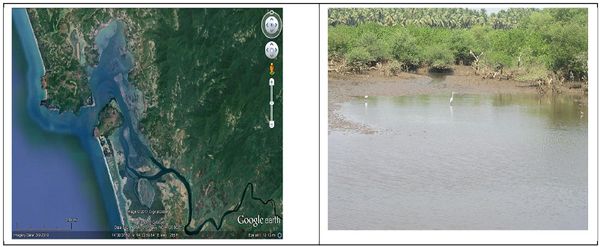
Figure 4: Aghanashini estuary in Kumta taluk, Uttara Kannada district
Sharavathi estuary - Sharavathi estuary lies between Lat 14.241O to 14.385O N Long 74.418O to 74.507 O E of Honavar taluk of Uttara Kannada district having an area of 1600 ha (Figure 6). The river has its origin at Tirthahalli taluk of Shimoga district and it joins the Arabian Sea at Honnavar. The estuary is brackish in dry weather but during the rains it sweet even close to the mouth. About 8 Km from the mouth, the river widens to lagoon, about 3 Km broad containing a few islands. Towards the estuaries, swamps induce saline sand cultivation. In spite of the silted-up harbour and treacherous sand bar at the mouth, there is a good deal of sailing traffic.

Figure 5: Sharavathi estuary in Honavar taluk, Uttara Kannada district
Venkatapura estuary - The Venkatapura river (total length 20 Km ) rising in the Sahyadri , near the village of Kranti north east of Bhatkal Taluk falls into the Arabian Sea near Venkatapur and forming a small estuarine expanse located between Lat 14.008o to 14.085o N Long 74.502o to 74.569o E.
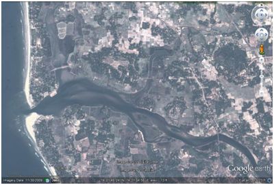
Figure 6: Venkatpur estuary in Bhatkal taluk, Uttara Kannada district
Boominathan et al (2008) documented the diversity and distribution of edible bivalve species and carried out a questionnaire based survey in the households of bivalve collecting villages in the nearby areas. They quantified the bivalve collection per person per day and estimated the expenditure incurred in collection and value obtained from it. They found that the bivalve collectors collected eight different species of edible bivalves and the edible bivalves were popularly categorized into clams, mussels and oysters. They estimated that 2,347 individuals from 1,202 households were associated with bivalve harvesting; of which 1,738 were men and 609 were women, who belonged to 19 estuarine villages and 1,202 families. The Bivalve harvested in this estuary was estimated to be 22,006 t/yr, which generated a total primary annual net income of about Rs. 57.8 million (Rs. 57,018,710 from bivalve collection and Rs. 816,267 from supplementary products like empty shells and dried meat). The Aghanashini village, which accounted for the highest production of bivalves alone earned about Rs. 33 million (58% of total income). The average income for the male was Rs. 29,129 from 140 collection days for the study year 2006-07, whereas it was Rs. 10,497 for the female from 147 collection days.
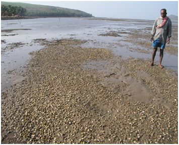
Figure 7: Bivalve resources in Aghanashini estuary
Sannadurgappa (2010) conducted an intensive study for assessing water quality, fish diversity and characteristics and effects of coastal ecosystem pollution in Aghnashini estuary. Detailed surveys of the local fishermen population were conducted from 2006-2008 for obtaining information related to fishery resources, trends, status, pattern of use changes in the status of fishery resources over the years. The results indicated that the estuary had exceptional fish diversity with a high degree of endemism due to the presence of many rare and localized forms. However, the human activities have impacted the quality of water in local waterways and downstream marine environments by increasing the levels of nutrients, sediments and other pollutants discharged via local waterways to the estuary. The average fish yield in the estuary was found to be reduced from 80% to 25% with 10% of the fishes being disappeared in the last 20 years.
Hegde et al (2004) tried to understand the depositional environment though textural study of the sediments from Sharavathi river estuary located near Honnavar in Uttara Kannada district. Number of samples were collected from 9 different stations set up within the Sharavathi river estuary representing different geomorphic setup and were analyzed for various textural parameters. The textural variations of the sediments showed medium to fine grained with the majority being medium grained. The sediment distribution pattern indicated that the mouth region was dominated by fine-grained sediments in all the seasons. The study indicated that during monsoon season, high energy condition enabled the river to discharge its sediments load into the sea whereas during the pre and post-monsoon season, these sediments entered the estuary owing to tidal effect and low energy of the river causing siltation in the estuary.
Hedge et al (2009) discussed the low scale foreshore changes and sediment distribution pattern of the Shravathi estuarine environment based on the seasonal foreshore profile variation, sedimentcharacteristics, wave refraction analyses, and in situ wavemeasurements. In general, the foreshore was found to be composed of medium to fine grained, well sorted to poorly sorted sands. The study indicated two distinct geomorphic processes on either side of the river mouth. The near shore coastal processes and the winds were found to be largely controlling the shoreface modification of the beaches to the south of the river mouth, whereas the islands in this region were found to be modifying the geomorphic processes of the beach to the north of the river mouth. The northerly drift prevailing duringthe post-monsoon season favoured spit growth across the river mouth from south to north, while the southerly driftduring December to February was responsible for erosion of the portion of the beach to the north of the river mouth.
Clams and oysters constitute major molluscan resource of the estuaries of India. Rai (1932) had made some observations on the resource of clams and oysters of the old Bombay Presidency, in which the coastal stretch of Karwar-Honavar was included. The magnitude of shell deposits in the estuaries of Karnataka and their chemical composition was studied by Gopal et al (1976) and Venkatakumaran and Bhat (1978). Later, Rao and Rao (1985) made a detailed survey of the clam and oyster resources of the estuaries in the region between Mangalore and Honavar during 1979 and 1980. The results highlighted that of the estimated 6700 tonnes of clams and oysters in the estuaries surveyed, 80% were clams and 20% were oysters.Among clams Meretrix casta was the chief species, followed by Villorita cyprinoides, Paphia malabarica, Meretrix meretrix and Katelysia opiina. Crassostrea madrasensis was found to be the dominant species of oyster collected from the estuaries.
Among the four estuarine systems of Uttara Kannada district, Kali estuary is the major one draining into the Karwar Bay. Its terrigenous transport into the coastal waters has been found to enhance the nutrient budget of the area, consequently supporting a rich biological production (Bhat et al, 1988). The seasonal variation in various parameters of the estuary observed by Neelakantan et al (1988) revealed that the temperature was comparatively low during monsoon, increased during post monsoon and reached maximum during pre-monsoon period. The salinity values were found to be high during pre monsoon period with lesser values observed during monsoon and post monsoon period. The nutrient budget of the estuary was found to be influenced by south-west monsoon, with the high silicate values at the upper stretches of the estuary.
While studying the hydrology of bottom waters of Kali, Bhat (1984) had observed that temperature and salinity had similar trends of variations while the salinity and silicate values had an inverse relationship. Primary production increased in the post monsoon period reaching its peak in November, following that of the nutrients. The conclusion drawn from the study indicated that post monsoon was the period when the estuarine water got enriched with nutrients and basic food.
Gunaga and Neelakantan (1987) studied the hydrological parameters of the Kali estuary at Nandangadda in relation to the different lunar phases during monsoon period as part of the investigation on ecological conditions of the Kali estuary. The fluctuation in salinity levels was found to be around full-moon and new moon days with the minimum levels during half-moon day. The concentrations of dissolved oxygen in general was found to be high during low and rising tides and low during high and receding tides. Hence, it was observed that tide played a significant role in controlling fluctuations of salinity and dissolved oxygen.
Neelakantan et al (1987) conducted a detailed study on the water quality, soil fertility and biotic components (planktonnes and benthos) in five stations covering back waters, brackish water creeks and mangroves adjoining Kali estuary to assess the aquaculture potential of Kali estuarine complex. Out of the total 1217 acres of low lying area in the estuarine system, 750 acres area was found to be suitable for aquacultural practices and most of the soils encountered during the study were silty sand and clayey sand with good amounts of organic carbon, nitrogen and phosphorus. The common phytoplankton population in the study area was found to be constituting of diatoms, dinoflagellates, blue green algae and green algae whereas the zooplanktonnes included crustaceans, copepods and protozoans. The macrobenthic diversity in the areas surveyed included polychaetes, gastropods, bivalves, amphipods, isopods and decapods.
In their study on phytoplankton distribution in Kali estuary, Kusuma et al (1988) observed that the plankton population followed a bimodal cycle of yearly abundance, one during the pre-monsoon period and other during the post-monsoon period. The greatest population density of phytoplankton (54,175 counts/m2) was observed in February while the least population density (1229 counts/ m2) was observed in August. The phytoplankton population constituted of diatoms such as Thalassiosira, Nitzschia, Coscinodiscus, Asterionella, Rhizosolenia and Dinoflagellates such as Noctiluca and Ceratium. The major components of zooplankton population constituted of protozoans, larval stages of polychaetes, chaetognaths, pteropods, appendicularians and larval forms.
Gunaga et al (1990a) studied the effects of tidal and lunar phases on the penaeid prawn seed abundance by making fortnightly collections of water and penaeid prawn seed samples alternatively on low and high tides on or around half moon days during November 1986 to November 1987. The observations made on lunar periodicity revealed that the new moon collections of penaeids showed numerical superiority over those of full moon and half moon collections indicating that the moon phase affected the abundance of penaeids. Gunaga et al (1990b) also carried out a detailed study to find the relative abundance of late post-larval and juvenile stages of penaeid prawn seeds at different tidal heights in Kali estuary. The distribution of penaeid prawn seed appeared to be influenced by tidal fluctuations with the collections being better at the time of low tides. No direct or indirect evidence was observed in the study for schooling behavior and no direct relationship could be established between the hydrological parameters and the abundance of seed. It was observed that with the onset of low tide, there was a gradual fall in the water level resulting in subsequent exposure of submerged area, which could have resulted in the maximum occurrence of prawn seed at or near the time of low water.
Bhat et al (1996) collected the water and plankton samples at fortnightly intervals from five selected stations at the inshore waters of Karwar and Kali estuary for delineating the composition, abundance and environmental impact of pelagic larvae in the planktonic assemblage of the inshore waters the estuaries. The results revealed the presence of 27 different types of larval forms belonging to 6 major taxonomic groups from the study sites. The temporal distribution of larvae indicated high larval abundance during the months of August to November. Among the abiotic factors taken into consideration during this study, the water temperature, salinity and dissolved oxygen were found to be significantly influencing the larval distribution.
Thomson (2003) conducted detailed socio-economic surveys for valuation of various direct, indirect and non-use values of Kali estuary in Karnataka and Cochin estuary in Kerala. A total of 469 households were found to be engaged in gazani paddy cultivation in Kali estuary with an average annual income generated to be Rs. 12,216,491 whereas in the case of Cochin estuary the income generated from Pokkary paddy cultivation was Rs. 5, 83, 97,238. The gross value generated from fishing activities in Kali estuary was Rs. 271.8 lakhs, income generated from sand mining was Rs. 276.37 lakhs, clams and lime shell collections fetched revenue of Rs. 39.87 lakhs and the aquaculture generated income of Rs. 420.65 lakhs. The aggregate value of Cochin estuary from the traditional, modern, recreational and non-use values was found to be Rs. 44380 lakhs while the aggregate value of Kali estuary from the traditional and modern activities was found to be Rs. 1163.56 lakhs.
Sampath Kumar and Neelakantan (2006) studied the distribution of post larval and juvenile stages of Peneaus merguiensis in four different habitats adjoining the Kali estuary having different abiotic characteristics for a period of one lunar month during the pre-monsoon season. The results indicated that the variations in the densities were mainly due to the differences in substrate features such as pH, organic content, sediment fraction type and vegetation cover. The study also highlighted that though the larval stages of penaeids mostly preferred muddy substratums, they could tolerate other substratum also, if the habitat provides sufficient amount of food and protection. The occurrence and density of post larvae and juvenile stages of P. merguiensis in a specific habitat was found to be dependent upon particular environmental factors such as muddy substratum, optimal pH of water and sediments, water temperature, oxygen content, vegetation covers, etc.
References:
- Annigeri G.G. (1968), Hydrology of the inshore waters of Karwar Bay during 1964-66. Indian Journal of Fisheries, 15: 155-162.
- Annigeri, G. G. (1971), Estimation of mortality rates of the oil sardine Sardinella longiceps Val. Indian Journal of Fisheries, 18(1&2): 109-113.
- Annigeri G. (1972), Hydrological conditions in the inshore regions of Karwar during 1965-1967. Indian Journal of Fisheries, 19(1&2): 156-162.
- Annigeri G. (1979), Observations on the hydrographical features of the coastal waters of North Kanara during 1956-1966. Journal of Marine Biological Association of India, 21 (1 & 2): 128-132.
- Anoop P., Suryaprakash S., Umesh K.B. and Amjath Babu T.S. (2008), Economic valuation of use benefits of Ashtamudi estuary in South India. Proceedings of TAAL 2007: The 12th World Lake Conference, 1822-1826.
- Ansari Z.A. (1977), Macrobenthos of the Cochin backwater. Mahasagar, 10: 169-171.
- Balakrishna K. (1998), U-Th series radionuclides and heavy metals in Kaiga region and Kali River, Karnataka state and their adjoining Arabian sea. PhD thesis, Department of Marine Geology, Mangalore University.
- Balakrishna K., Shankar R., Sarin M.M. and Manjunatha B.R. (2001), Distribution of the U-Th nuclides in the riverine and coastal environments of the tropical southwest coast of India. Journal of Environmental Activity, 57: 21 – 33.
- Bannur C.R. (1994), Studies on the coastal environs using remote sensing techniques and morphology of beaches of Uttara Kannada district, Karnataka state, India. PhD thesis, Department of Geology, Karnatak University, Dharwar.
- Barbier B.E., Acreman M. and Duncan K. (1997), Economic valuation of wetlands: A guide for policy makers and planners. RAMSAR convention bureau, Department of Environmental Economics and Environmental Management, University of York, Institute of Hydrology, IUCN-the world conservation Union, Gland, Switzerland.
- Barlow P.G. and Bishop W.J. (1965), Phosphate regeneration by zooplankton in Cayuga Lake. Limnol. Oceanog.,10: 15-24.
- Bhat M.S. (1998), Morphology of the Beaches and Textural and heavy minerals of beach sediments between Gokarna and Kumta beaches, Uttara Kannada district, Karnataka, India. PhD thesis, Department of Geology, Karnatak University, Dharwar.
- Bhat U.G. (1984), Studies on the benthos of Kali estuary, Karwar. PhD thesis, Karnatak University, Dharwad.
- Bhat U.G., Neelakantan B., Kusuma N. and Naik U.G. (1988), Environmental characteristics of the marine and estuarine habitats of Karwar – an overview. Journal of Indian Fisheries Association, 18: 401 – 412.
- Bhat U.G., Bhosale S.H., Naik U.G. and Kusuma N. (1996), Distribution of pelagic larvae in the inshore and estuarine waters of Karwar. Indian journal of Fisheries, 42(2).
- Bhat V.T. (2002), Geoenvironmental evolution of coastal and hinterlands of Karwar, western coast of India: A tectonogeomorphic and remotely sensed data evaluation. PhD thesis, Department of Marine Geology, Mangalore University.
- Boominathan M., Subhash Chandran M.D. and Ramachandra T.V. (2008), Economic valuation of the Bivalves in Aghanashini estuary, West coast, Karnataka, ENVIS Technical Report no.30, Centre for Ecological Sciences, Indian Institute of Science, Bangalore.
- Chandran M.D.S (2000), Ecosystem studies and management in Coastal Uttara Kannada, CES Technical Report no.3, Centre for Ecological Sciences, Indian Institute of Science, Bangalore.
- Ganga U. (2000), Oil sardine fishery at Karwar. Journal of Marine Biological Association of India, 42(1&2): 112-123.
- Gopal B., M. Muniswamaiah and B. M. Krishna Reddy (1976), Lime shell deposits of Mangalore taluk. South Kanara District. Geological studies, No. 114, Government of Karnataka, Department of Mines and Geology, Bangalore.
- Gunaga V. and Neelakantan K. (1987), Changes in the hydrological parameters of the Kali estuary in relation to tides during monsoon period. Proceedings of National Seminar on Estuarine Management, pp. 73-75.
- Gunaga V., Neelakantan K. and Neelakantan B. (1990a), Tidal and lunar influences on Penaeid prawn seed abundance in the Kali estuary, Karwar. Mahasagar – Bulletin of National Institute of Oceanography, 23(1): 63-69.
- Gunaga V., Neelakantan K. and Neelakantan B. (1990b), Tidal occurrence of Penaeid prawn seed in the Kali estuary, Karwar. Indian Journal of Fisheries, 37(1): 37-43.
- Hanamgond P.T. and Chavadi V.C. (1993), Sediment movement on Aligadde beach, Uttara Kannada district, west coast of India. Journal of Coastal Research, 9(3): 847 – 861.
- Hanamgond P.T. and Mitra D. (2007), Dynamics of the Karwar coast, India, with special reference to study of Tectonics and coastal evolution using Remote sensing data. Journal of Coastal Research, Special Issue 50, 842 – 847.
- Hegde V.S., Gosavi K.D., Hanamgond P.T., Huchchannavar G.K., Shalini G. and Bhat M.S. (2004), Depositional environment and silting in the Sharavathi estuary, central West coast of India. Indian Journal of Marine Sciences, 33(3): 296 – 302.
- Hegde V.S., Shalini G., Nayak S.R., Rajawat A.S., Suryanarayana A., Jaykumar S., Koti B.K. and Girish G.K. (2009), Low-scale foreshore morphodynamic processes in the vicinity of a tropical estuary at Honnavar, central West coast of India. Journal of Coastal Research, 25(2): 305-314.
- Kurup K.N., Kutty Nair G.K., Annam V.P., Kant A., Beena M.R. and Kambadkar L. (1987), An appraisal of the Marine fisheries of Karnataka and Goa. CMFRI Special Publication No. 36, Central Marine Fisheries Research Institute, Cochin.
- Kusuma M.S., Neelakantan B. and Konnur R.G. (1988), Plankton distribution in the Kali estuary, Karwar, central west coast of India. Environment and Ecology, 6(1): 115-117.
- Kusuma N. and Neelakantan B. (1992), Sciaenid fishery of the Uttara Kannada coast, Karnataka. Journal of Marine Biological Association of India, 34(1 & 2): 54-62.
- Madhupratap M. (1981), Cladocera in the estuarine and coastal waters of south-west coast of India. Mahasagar – Bulletin of National Institute of Oceanography, 14: 215-219.
- Mandal S., Sanil Kumar V., Anand N.M., Nayak B.U. and Pednekar P. (1993), Deep water wave characteristics off Karwar West Coast of India. Technical Report No. NIO/TR-4/93, National Institute of Oceanography, Donapaula, Goa.
- Mislankar P.G. and Antao F.B. (1992), Textural studies of beach sediments from Sadashivagad and Karwar, Central West Coast of India. Indian Journal of Earth Sciences, 19(2-3): 70-78.
- Mohamed, K. S., C. Muthiah, P. U Zachariah, K. K. Sukumaran, P. Rohit and P. K. Krishnakumar (1998), Marine Fisheries of Karnataka state, India. Naga, The ICLARM Quarterly, 21(2): 10-15.
- Naik U.G. (1986), Studies on plankton and productivity of Kali estuary and inshore waters of Karwar. PhD thesis, Karnatak University, Dharwad.
- Naik U.G., Rathod J.L., Bhat U.G. and Kusuma N. (2005), Studies on the sediments of Binaga and Karwar Bay, west coast of India. Envrionment and Ecology, 23(4): 826 – 830.
- Naik U.G., Rathod J.L., Bhosale S.H. and Bhat U.G. (2006), Population dynamics of cladocerons off coastal waters of Karwar, west coast of India. Environment and Ecology, 24(2): 343-347.
- Naik U.G., Naik R.K. and Nayak V.N. (2006), Primary Productivity in the Karwar Bay, Karnataka, West Coast of India. Environment and Ecology, 24(4): 827-831.
- Nandakumar G. (1988), Observations on the fishery of banana prawn along the north kanara coast with notes on its schooling behavior and migration. Marine Fisheries Information Service No.81, Central Marine Fisheries and Research Institute, Cochin.
- Naomi T.S. (1986), On the zooplankton of the inshore waters of Karwar during 1980-81. Indian Journal of Fisheries, 33(3): 336-346.
- Neelakantan B., Prasad P.N., Naik U.G., Gunaga V.R. and Kusuma M.S. (1987), Culture potentiality of Kali estuary and adjoining brackish water systems. Proceedings of National Seminar on Estuarine Environment, Trivandrum, 350-358.
- Neelakantan B., Naik U.G., Prasad P.N. and Kusuma M.S. (1988), Hydrobiology of Kali estuary and adjoining brackish water systems, Karwar. Environment and Ecology, 6(1): 139-147.
- Noble A. (1968), Studies on the sea-water off the North Kanara coast. Journal of the Marine Biological Association of India, 10(2): 197-223.
- Radhakrishnan N. (1958), Observations on the mackerel fishery at Karwar for the seasons 1954-55 and 1955-56. Indian Journal of Fisheries, 5(2): 258-269.
- Radhakrishnan, N (1962), Observations on the maturity and spawning of Indian mackerel, Rastrelliger canagurta (Cuvier) at Karwar.Indian Journal of Fisheries, 9A (2). pp. 512-524.
- Rai H. S. (1932), The shell fisheries of the Bombay Presidency. Journal of Bombay Natural History Society, 35(4): 884-847.
- Ramamurthy S. (1965), Studies on the plankton of the North Kanara coast in relation to the Pelagic fishery. Journal of Marine Biological Association of India, 7(1): 127-149.
- Rao G.S. and Rao K.S. (1985), Survey of clam and oyster resources of some Karnataka estuaries. Indian Journal of Fisheries, 32(1): 74-89.
- Sampath Kumar S. and Neelakantan K. (2006), A study on the selection of habitat by the post larval and juvenile banana shrimp, Penaeus merguiensis in and around Kali estuary, Karwar, Karnataka. Journal of Current Sciences, 9(2): 773-778.
- Sannadurgappa D. (2010), Water Quality and human influence on coastal ecosystem of South India. Proceedings of BALWOIS – 2010, Ohrid, Republic of Macedonia.
- Scott D.A. (1989), Design of wetland data sheet on RAMSAR sites. Mimeographed report to Ramsar convention bureau, Gland, Switzerland.
- Sudarshana R. (1983), Studies on community ecology of macro and meiobenthos in Karwar Bay. PhD thesis, Karnatak University, Dharwad.
- Syda Rao G., Kuriakose P.S., Ramachandran N., Meiyappan M.M., Achary G.P.K., Nagaraja D. and Shivanna H.S. (1989), Atlas of Clam resources of Karnataka. CMFRI Special Publication No.46, Central Marine Fisheries Research Institute, Cochin.
- Thomson K.T. (2003), Economic and social management of estuarine biodiversity in the west coast of India. EERC Working Paper Series: MES-4.
- Veerayya M. and Pankajakshan T. (1988), Variability in wave refraction and resultant nearshore current patterns: Exposed versus sheltered beaches along North Karnataka, West coast of India. Indian Journal of Marine Science, 17(2): 102-110.
- Venkatakumaran, C. N. and C. N. A. Shankar Bhat (1978), Lime shell deposits in coastal belt North Kanara District, Karnataka. Geological studies. No. 122, Government of Karnataka, Department of Mines and Geology.
- Wilson, M. A., Costanza, R., Boumans, R. M. J. and Liu, S. L. (2005), Integrated Assessment and Valuation of Ecosystem Goods and Services Provided by Coastal Systems. In The Intertidal Ecosystem, ed. (James G. Wilson), 1/24 pp. Royal Irish Academy Press. Dublin, Ireland.
