STUDY AREA
Sharavathi river basin, Central Western Ghats was chosen to study the status of native tree species, habitat of endemic Lion tailed macaque (LTM) and for evolving strategies to conserve threatened species of flora and fauna. Energy and Wetlands Research Group (EWRG) at Centre for Ecological Sciences (CES), Indian Institute of Sciences (IISc) with research facilities has been carrying out conservation research in the Sharavathi river basin (Figure 2 and 3). This study focuses mainly on LTM’s, habitat condition and conservation and management aspects of the fragile ecosystems in Sharavathi river basin.
1. The Sharavathi River Basin: Sharavathi River is one of the important west flowing rivers of Karnataka. The river originates near Ambutirtha village, Tirthahalli Taluk of Shimoga district at an elevation of about 730 m and runs through the districts of Shimoga and Uttara Kannada (Figure 3). At Jog, the river drops precipitously from a height of 253 m into a deep gorge creating, one of the most spectacular scenes of the Western Ghats. The major tributaries of the river are, Nandiholé, Haridravathi, Sharmanavathi, Hilkunjiholé, Nagodiholé, Hurliholé, Yenneholé, Mavinaholé, Gundabalaholé, Kalkatteholé and Kandodiholé. The total catchment area of the river up to Honnavar is 3600 km2 where it joins the Arabian Sea. The entire catchment is very steep and thickly wooded.
The river basin has been harnessed for hydroelectric power projects to its fullest potential. The Mahatma Gandhi Hydroelectric Project was commissioned in 1948. This was followed by Sharavathi Generating Station commissioned in 1964-65, Linganamakki Dam Power House and the Sharavathi Tail Race Project at Gersusoppa in 2002. These account for about 45% of the total installed capacity of hydroelectric power in the state. Sharavathi River alone, in its fullest potential, accounts for an estimated electricity generation of about 6,000 million units (kWh) per annum (Ramachandra et al., 2007).
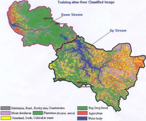
Figure 2: Sharavathi river basin (with sampling points)
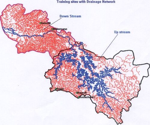
Figure 3: Drainage network (Sharavathi river basin)
The river water is stored in three major reservoirs, at Linganamakki (14º10’24” N, 74º50’54” E), Talakalale (14º11’10” N, 74º46’55” E) and Gerusoppa (14º15’N, 74º39’ E). The areas submerged for these reservoirs are 326.34, 7.77 and 5.96 km2 respectively. The Linganamakki reservoir resulted in the full or partial submergence of 99 villages in the Sagar and 76 villages in the Hosanagar Taluk of Shimoga district, also causing the displacement of 12,000 people. The Talakalale reservoir resulted in the full or partial submergence of 3 villages in the Sagar Taluk. Gerusoppa reservoir lead to the submergence of 5.96 km2 of tropical evergreen to semi-evergreen forests. Additionally, for the Sharavathi Tail Race Project, 4.72 km2 of forest and 0.08 km2 of other lands were also acquired for township, roads, etc. (Ramachandra and Subash Chandran, 2003) The entire Sharavathi river basin along its upstream and downstream comprises of the Linganamakki Dam/ Reservoir and Gerusoppa Dam/Reservoir respectively.
Hydro meteorological characteristics of Sharavathi River Basin:
Temperature and Humidity: Relative humidity is generally high at around 75% during southwest monsoon season and moderate during the rest of the year. Humidity during summer afternoons is relatively lower. Average minimum and maximum temperature is about 15 to 38ºC.
Wind: Wind is generally moderate with some increase in strength in monsoon months. From May to September, winds are mainly southwesterly or westerly and on some afternoons, northwesterly. Northeasterly and easterly winds appear in October and predominate till the end of January. There is a gradual shift of winds in a clock-wise direction from February. By April, the wind is mainly southwesterly in the mornings and partially northeasterly and southeasterly in the afternoons.
Linganamakki Dam: The Linganamakki reservoir has a catchment area of nearly 1991 km2. It receives water mainly from rainfall and also from the Chakra and Savahaklu reservoirs, which are linked to Linganamakki through a canal. The water from the reservoir flows to Talakalale, balancing the reservoir through a trapezoidal canal with a discharge capacity of 175.56 m3. The length of this channel is about 4318.40 m with a submergence of 7.77 km2. It has a catchment area of about 46.60 km2. The gross capacity of the reservoir is 129.60 m3 (Ramachandra and Subash Chandran, 2003).
Gerusoppa Dam: Sharavathi River with tailrace water of Mahatma Gandhi Hydel Station is carried by Sharavathi river to Gerusoppa Dam, which is built on this river. The dam is 58 m high, 423 m long, made of concrete with gross storage of 150 M.cum. The Gerusoppa Dam (in Honnavara Taluk of Uttara Kannada district) lies between Latitude 14º14'30"(N) and Longitude 74º37'15"(E). For a better understanding of the details of Shimoga and Uttara Kannada districts are included in the Annexure (annexure 1) as Sharavathi River Basin falls in these two districts.

