Sahyadri Conservation Series - 4 ENVIS Technical Report: 21,  February 2012
http://www.iisc.ernet.in/
WATER, SOIL AND SEDIMENT CHARACTERIZATION: SHARAVATHI RIVER BASIN, WESTERN GHATS
http://wgbis.ces.iisc.ernet.in/energy/
Ramachandra T V             Subash Chandran M.D             Joshi N.V.             Rajinikanth R.             Raushan Kumar
Energy and Wetlands Research Group, Centre for Ecological Sciences,
Indian Institute of Science, Bangalore – 560012, India.
*Corresponding author: cestvr@ces.iisc.ernet.in

STUDY AREA

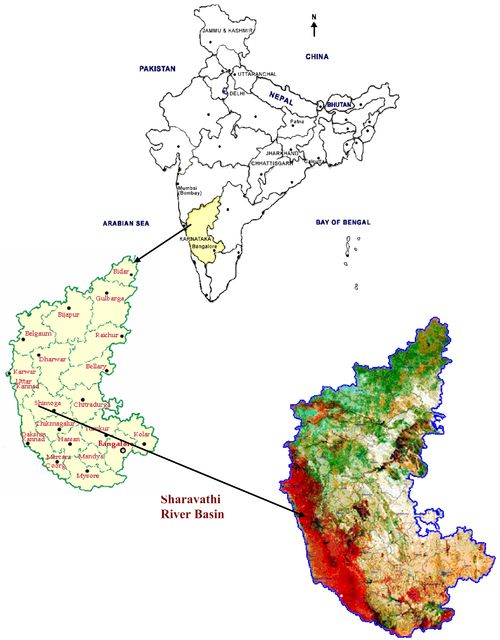
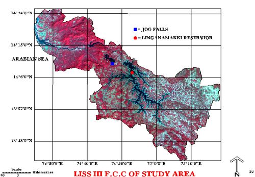
Sharavathi originates in the Western Ghats near Ambuthirtha in Thirthahalli taluk of Shimoga district (Figure 1.1). Flowing north-west, it is mainly used for generation of hydroelectric power. The river with its tributaries flows along the rugged terrain of Western Ghats of south-west Shimoga and south-east Uttara Kannada districts (Figure 1.2). This region supports a rich diversity of flora and fauna. The Karnataka Power Corporation Limited constructed a dam across the river in 1964 near Linganamakki, which is one of the oldest hydroelectric power projects in India. Linganamakki hydroelectric project has caused submersion of a large area along with loss of biodiversity. The aquatic and soil ecosystems are the major resources under threat. In this context it would become necessary to assess the cumulative impact of the construction of the dam on the river ecosystem i.e., on the water, soil and sediment status by sampling and analysing the sampled data.

Figure 1.1: Location of Sharavathi River Basin, Karnataka, India

Figure 1.2: Sharavathi River Basin


E-mail    |    Sahyadri    |    ENVIS    |    GRASS    |    Energy    |    CES    |    CST    |    CiSTUP    |    IISc    |    E-mail