|
STUDY AREA
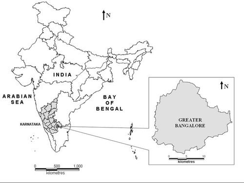
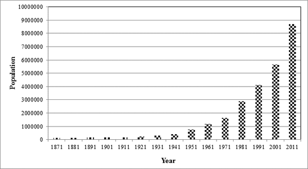
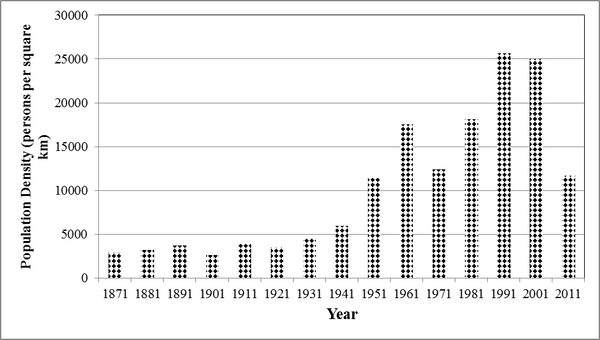
Greater Bangalore (77°37’19.54’’ E and 12°59’09.76’’ N) is the principal administrative, cultural, commercial, industrial, and knowledge capital of the state of Karnataka with an area of 741 sq. km. Bangalore city administrative jurisdiction was widened in 2006 by merging the existing area of Bangalore city spatial limits with 8 neighbouring Urban Local Bodies (ULBs) and 111 Villages of Bangalore Urban District (Ramachandra and Kumar, 2008; Sudhira et al., 2007). Thus, Bangalore has grown spatially more than ten times since 1949 (69 square kilo meters) and is a part of both the Bangalore urban and rural districts (figure 1.1). The mean annual total rainfall is about 880 mm with about 60 rainy days a year over the last ten years. The summer temperature ranges from 18° C – 38° C, while the winter temperature ranges from 12° C – 25° C. Thus, Bangalore enjoys a salubrious climate all round the year. Bangalore is located at an altitude of 920 meters above mean sea level, delineating three watersheds, viz. Hebbal, Koramangala-Challaghatta and Vrishabhavathi watersheds (figure 1.2). The undulating terrain in the region has facilitated creation of a large number of tanks providing for the traditional uses of irrigation, drinking, fishing and washing. Bangalore had the distinction of having hundreds of water bodies through the centuries. Even in early second half of 20th century, in 1961, the number of lakes and tanks in the city stood at 262 (and spatial extent of Bangalore was 112 sq. km). However, number of lakes and tanks in 1985 was 81 (and spatial extent of Bangalore was 161 sq. km). This forms important drainage courses for the interconnected lake system (Figure 1.2), which carries storm water beyond the city limits. Bangalore, being a part of peninsular India, had the tradition of harvesting water through surface water bodies to meet the domestic water requirements in a decentralised way. After independence, the source of water for domestic and industrial purpose in Bangalore is mainly from the Cauvery River and ground water. Untreated sewage is let into the storm water drains which progressively converge at the water bodies. Now, Bangalore is the fifth largest metropolis in India currently with a population of about 8.72 million as per the latest population census (figure 2). Population has increased from 4,10,987 (1941) to 41,30,288 (1991), 56,55,844 (2001) and 87,199,39 (2011). Spatial extent of the city has increased from 69 (1941) to 161 (1981), 226 (2001) and 745 (2011) sq.km. Due to the changes in the spatial extent of the city, the population density varies from 5956 (1941) to 18147 (1981), 25653 (1991), 25025 (2001) and 11704 (2011) persons per sq.km.

Figure 1.1: Study area – Greater Bangalore

Figure 1.2: Watersheds (drainage with water bodies) of Greater Bangalore


Figure 2: Population growth and population density
|


