Data analyses :
Data analyses involved:
- Calculations of the area of sub-catchments and land use analysis,
- Computation of water yield in respective sub-catchments,
- Suitable location of harvesting structures,
- Optimal capacity of the pond.
The sub-catchments were delineated from the main catchment area and coefficients of runoff were given to each according to their catchment characteristics. The daily precipitation data at Bangalore city observatory from 1990 to 1997 were used to arrive at a water yield of the pond. Daily yield was calculated using the rational formula, which was computed for the catchment for all these years. Daily yield was cumulated to obtain the monthly and yearly yields.
Topographical analyses with the help of DEM suggest suitable location of the harvesting structure in the eastern part of the campus, which is currently a marshy region. About 1.5 hectare land is available in this region to construct harvesting structure.
During the early 1960's, there were many lakes around the campus that acted as water storage structures and aided in groundwater recharge mechanism. Anthropogenic stresses have led to conversion of lakes to residential, commercial layouts and public utilities. Recent study shows that about 35 % lakes have disappeared during the last twenty years (Deepa, et al. 1998). Aswathnarayana-kere and Nagashettihalli-kere in the vicinity of IISc are now non-existent, and have been converted into residential layouts. Figure 3 shows the IISc campus bounded by the existing lakes. Consequently, during peak rainfall season, water from the catchment gets into the low-lying areas adjacent to the IISc campus (like ISRO Head quarters, Vigyanapura, etc.).
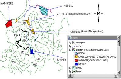
Figure 3: IISc campus bounded by the existing lakes.
The three-dimensional elevation image generated using Geomedia Grid was used to identify suitable location for this rainwater-harvesting pond. Figure 4 shows the DEM of the IISc campus. With an identification of lowest positions in a region, the possibility of channeling water was explored considering the following aspects.
Social :
|
Acceptance of pond and usage of its water by people in the vicinity.
Proper managerial solution to avoid breeding of mosquitoes. |
Technical :
|
Remedial measures to prevent water seepage into the soil taking into account the stability aspects of structures in the vicinity. |
Ecological :
|
Environmental impact assessment to ensure minimum damage to the ecosystem from biodiversity point of view. |
Economical :
|
To ensure cost effective structure. |
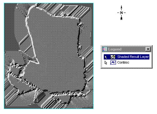
Figure 4: Digital Elevation Model of the IISc campus.
All possible locations were identified in the campus. The best option was selected considering above criteria and based on the simplicity of construction and channeling of the storm water. The pond was located at a point where the storm water drained can be channeled without much alterations of the existing drainage network.
After identification of suitable location for constructing harvesting structures (ponds), region was explored to find out the extent of land available. Location and area were decided based on ecologically sound strategies. From the land use map, Figure 5 gives the land use map of IISc campus based on utility (vector layer) of the spatial coverage of possible harvesting structure (pond / reservoir) was prepared. The area available ranges from 1 to 1.5 ha. One and half hectare spatial coverage entails removal of about 15 trees belonging to Acacia nilotica species. Considering these two areas and for different depths, capacity of the pond was computed.
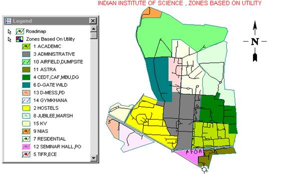
Figure 5: Land use map of IISc campus based on utility.
Volumes were compared with the water yield of the catchment of the campus considering the continuity equation i.e.
Storage volume = Inflow – Outflow - Losses (evaporation, seepage, etc.)
The losses considered were the evaporation from the catchment using the monthly mean of daily evaporation data for Bangalore (Muthreja, 1995). The demand for the swimming pool, gardening was ascertained from the volume of the swimming pool and the volume of the storage tank for gardening respectively.
The average rainfall of Bangalore was computed taking 55 years (from 1940 to 1997- 1948, 1967 were not available) of daily rainfall data from Bangalore city observatory.
Harvesting structure in an available area of 1.5 ha and a depth of about 3 m can hold about 22000 m3 of rainwater. This is sufficient to meet the requirement of swimming pool, gardening and toilet usage in the campus. The campus swimming pool approximately requires 1000 m3 of water per refilling. The pool faces scarcity of water during the lean season (i.e. during month of January, February and March). Apart from this, storage structures helps in recharging of the groundwater sources.
The maximum depth available at the proposed site is about 1.5 m. It is desirable to increase this to about 3m, so that the storage may be increased. All round excavation may be taken up to achieve a maximum depth of about 3 m, and to give aesthetic appearance.
Inlet to the pond: The existing main drain that runs in the eastern parts of the campus collects a major portion of the storm water. The lowest point on this drain occurs opposite to the proposed pond location, which could be easily connected to the pond.
Outlet from the pond: An outlet drain of size 1.8 m width and 1.2 m height must be provided at a slope of 1 in 1000, and joined to the existing drain leading to the municipal drain along the eastern part. The invert level of this outlet drain must be the same as that of the inlet drain.
Maintenance of water quality: Adequate care and attention must be focussed on maintenance of clear water in the pond, so that it does not become a source for unhygienic and unpleasant surrounding. Under no circumstances, sewage water and other waste water must be permitted inside the pond. For prevention of mosquito breeding, periodic treatment with lime and/or biological control is required.
|


 Top
Top