STUDY AREA
Indian Institute of Science (IISc) campus has been considered for the present study. The campus limits are enclosed within 13°00'38''N to 13°01'15''N latitude and 77°33'34''E to 77°34'26''E longitude. The area falls in the 57G/12 of SOI topo-sheet of scale 1:50000, 57G of scale 1:250,000. IISc is located in northern part of Bangalore city and Figure 1 gives the map of IISc campus with important landmarks. It is endowed with lush green vegetation and has a green canopy of trees covering the buildings in the campus.
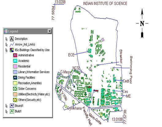
Figure 1: Map of IISc campus with important landmarks.
The campus, consisting of five bounds, covers an area of 180 ha. The main campus covers 158 ha. The altitude of campus varies from 914m (from Mean Sea Level) to 942 m. The natural terrain of the campus is rolling and provides good natural drainage. The campus slopes towards three sides (north, east and west) from a central ridge along the middle and along the main road of the campus (Gulmohar Marg). Historical precipitation data of 54 years reveal that, the major portion of rainfall being May-June and thunderstorms during September-October. Bangalore receives mean annual rainfall of 860 mm (Radhakrishnan et al., 1996). Sankey Lake located to the Southeast of the campus. A large drain running all along the eastern side of the campus forms the main feeder of the Sankey Lake. |