|
Study Area and Data
Greater Bangalore capital of Karnataka, India with a spatial extent of 741 km2 is geographically located at 12o49’5”N to 13o8’32”N and 77o27’29” E to 77o47’2”E in the south eastern part of Karnataka state (Fig. 1). Bangalore urban area has spatially increased from 69 sq.km (1901) to 741 sq.km (2006) [1]. The study has been carried out for Bangalore with ten km buffer (with a gross area of 2290 sq.km) to account for likely sprawl in peri-urban regions.
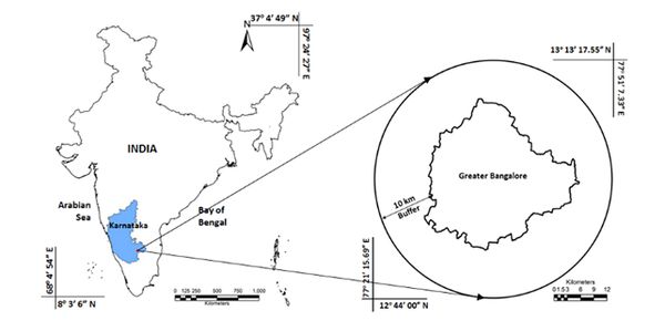
Fig.1. Study Area
The undulating terrain with elevation ranging from 700 m to about 962m AMSL of the region has aided in the formation of cascaded lakes with interconnecting drains. Large number of water bodies with green cover has aided in moderating the city climate and maintaining salubrious climate. Temperature varies from 22°C to 38°C during summer and 14 °C to 27°C in winter. Bangalore receives an annual average rainfall of 824 mm. geologically the area consists of Granitic and Gneisses rocks in large scale [16].
The population [1] of Bangalore (BBMP) has increased to a large extent in a decade at a rate 44% i.e., from 5,840,165 (2001) to 8,395,947 (2011) at a rate of 4.4% annually, higher than the national average of 2.5%. The population density in the region has increased from 8179 (2001) to 11756 persons/km2 (2011). Bangalore has a decadal increase of 44%, which is very high compared to that of Karnataka state (31.5%) and India (31.8%).
Table 1 lists the data used for land use analysis. Temporal remote sensing data of Landsat TM and ETM+ were used to analyse and model LULC changes. Remote sensing data were supplemented with the Survey of India toposheets of 1:50000 and 1:250000 scale, and Bhuvan data, which were used to generate base layers of the administrative boundary, drainage network, Road network etc. Ground control points (GCPs) and training data were collected using pre calibrated Global Positioning System (GPS) and virtual online spatial maps such as Google Earthand Bhuvan GCPs were useful in geometric correction of remote sensing data.
Table1: Materials used in analysis
| Data |
Year |
Description |
| Landsat
TM (28.5m) |
2008, 2010,
2012 |
Land Use Land Cover Analysis |
| ASTER DEM
(30 m) |
2012 |
Generation of Slope map |
| SOI toposheets |
|
1:250000 and 1: 50000 toposheets for delineating administrative boundaries, and geometric correction, Delineation of road network |
| Bhuvan |
|
Support data for Site data, Delineation of road network, Delineation of village and city boundaries |
| GPS |
|
classification and data validation |
| Google Earth |
|
Support data for site data, Delineation of road network, preparation of point database files as input for modelling |
| Census |
1991,
2001, Provisional 2011 |
Population census for growth monitoring |
Training data were used for classification, verification and validation of the classified results.Google earth data was also used to extract the point data such as location of industries, bus stops, railway stations, metro stations, social, religious structure’s, cemeteries, educational and others (police stations, hospitals, theatres) and line features such as road network. These features were verified in the field using handheld calibrated GPS.
|
