Study Area
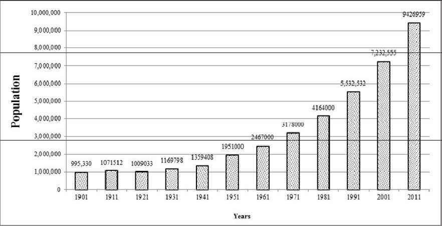
Pune, earlier known as Poona is the cultural capital of Maharashtra and is also known as “Queen of Deccan” as it is located atop the Deccan Plateau and also “Oxford of East” and “Detroit of India”. Pune is located in the western part of Maharashtra state between 18°32´ N and 72° 51´E at a height of 560 m above mean sea level. It lies near the confluence of the Mula-Mutha River. Rivers Pavana and Indrayani flows along the north-western outskirts of the urban area. The Pune Municipal Corporation covers an area of 243.84 sq. kms. Pune has a tropical wet and dry climate, with three distinct seasons- Summer(March to May), Monsoon (June to September) and Winter (November to January).The River Bhima flows through the city and provide water supply for the domestic, commercial and irrigation purpose. Rice, Jowar, Bajra, sugarcane, groundnut and sunflower are major crops grown in the Pune. Fig. 1 depicts the population dynamics during 1901 to 2011 showing an increase by 347% during the last 110 years. Pune being one among incipient mega cities in India has seen the large scale development in recent times. Population of Pune has increased by 2 million to 9 million (Census 2011) from 7 million in 2001 (Census 2001, JNNURM, 2006-2012). Fig. 1 shows the population statistics of Pune in last 100 years.
Fig. 1: Growth of population in Pune
|
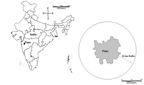
Pune Municipal Corporation with forty-eight wards is the civic body that is responsible administration and infrastructure development of the city and it is known as the Pune Mahanagar Palika (PMP). The current study has been carried out in a region of 1524.4 sq. km consisting of municipal corporation administrative region with 10 km buffer. Buffer of 10 km is considered to account the growth in the peri-urban regions (Fig. 2). Time series spatial data acquired through Landsat Series Multispectral sensor (57.5m) and thematic mapper (30m) and Landsat 8 operational image scanner (30m) sensors for the period 1973 to 2013 were downloaded from a public domain Global Land Cover Facility (http://www.glcf.umd.edu/index.shtml) and (http://www.landcover.org/). Survey of India (SOI) topographic sheets of 1:50000 and 1:250000 scales were used to generate base layers of city boundary, training sites, etc.
Fig. 2: Study area considered, Pune and 10km buffer.
|
