 |
Stimulus of Developmental Projects to landscape dynamics in Uttara Kannada, Central Western Ghats
|
 |
aEnergy & Wetlands Research Group, Center for Ecological Sciences [CES], Indian Institute of Science, Bangalore, Karnataka
560 012, India, b Centre for Sustainable Technologies (astra), Indian Institute of Science, Bangalore, Karnataka 560 012, India cCentre for Infrastructure, Sustainable Transportation and Urban Planning [CiSTUP], Indian Institute of Science,
Bangalore, Karnataka 560 012, India
dInternational Institute of Information Technology-Hyderabad [IIIT-H], India
Web URL: http://ces.iisc.ac.in/energy; http://ces.iisc.ac.in/foss
*Corresponding author: cestvr@ces.iisc.ac.in
|
STUDY AREA
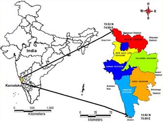
The Uttara Kannada district (13.92o to 15.53o North and 74.09o to 75.09o East) has the distinction of having highest forest cover in the state of Karnataka, India. The district has a tropical climate with the mean annual rainfall of 4237 mm and elevation ranges from 0 to 1050 m. The district has five forest divisions and one wildlife division (Figure 1) covering 11 taluks (local revenue administrative division). The region is the repository of exceptional biodiversity with higher endemism, which is due to the humid tropical climate, topographical and geological characteristics, and geographical isolation (Arabian Sea to the west and the semiarid Deccan Plateau to the east). The region is part of the Western Ghats, one among 34 global hotspots of biodiversity. The total population of the district is 1502454 (as per 2011 census) with population density of 146 persons per sq.km. The costal and plains have been expressing higher population presence while Sahyadri’regions with moderate pressures. The district has 140 km coastal line and the west flowing rivers (Kali, Bedthi, Aganashini, Sharavathi, Venkatapur) break the shoreline of Uttara Kannada by deep and wide mouthed estuaries, larger creeks with ample biodiversity (Mesta et al., 2014). However, due to lack of environmental accounting of natural resources, the administration has branded the district as backward district. Many projects such as paper and pulp based industries, plywood Industries, power projects, mining etc. were taken up in the district on ad-hoc basis and impacts of these decisions are evident from barren hill tops, lowered quantity and duration of stream flow, etc. Large reservoirs on Kali and Sharavathi, for hydroelectricity generation have submerged vast tracts of natural forest and displaced large number of families. The region has witnessed large scale migrations, encroachment of forest lands and conversion to agricultural lands (with the implementation of project due to water availability). This has led to the large scale land cover changes with retreat of forests, soil erosion, loss of productive top soil layer, alterations in hydrologic regime in each basin leading to lowered catchment yield. Encroachment of forest lands, conversion of natural forests to monoculture plantations of exotic species, etc. have resulted in the fragmentation of forests and animal habitats resulting in higher instances of human-animal conflicts. Cumulative impacts of all these activities are evident from the disappearance of endemic species and erosion of biodiversity in the region. Annexure A lists the land allotments made for various developmental activities by the State government since 1956.

Figure 1 Study area-Uttara Kannada district, India.
|
|
Citation :T.V. Ramachandra, Bharath Setturu, K.S. Rajan, M.D. Subash Chandran (2016). Stimulus of developmental projects to landscape
dynamics in Uttara Kannada, Central Western Ghats. The Egyptian Journal of Remote Sensing and Space Sciences (2016), http://dx.doi.org/10.1016/j.ejrs.2016.09.001, pp.1-19.
|


