 |
MODELLING THE FOREST TRANSITION IN CENTRAL WESTERN GHATS, INDIA |
 |
T.V. Ramachandraa,b,c*, Bharath Setturua,d, Rajan K Sd, Subash Chandran M. Da
aEnergy & Wetlands Research Group, Center for Ecological Sciences [CES], http://ces.iisc.ac.in/energy
bCentre for Sustainable Technologies (astra),
c Centre for infrastructure, Sustainable Transportation and Urban Planning [CiSTUP],
Indian Institute of Science, Bangalore, Karnataka, 560 012, India
dLab of Spatial Informatics, IIIT-H, Hyderabad, India.
*Corresponding Author: cestvr@ces.iisc.ac.in
|
STUDY AREA
The Western Ghats is one among the 35 global hotspots of biodiversity and it lies in the western part of peninsular India in a series of hills stretching over a distance of 1,600 km from north to south and covering an area of about 1,60,000 sq.km. It harbours very rich flora and fauna and there are records of over 4,000 species of flowering plants with 38% endemics, 330 butterflies with 11% endemics, 156 reptiles with 62% endemics, 508 birds with 4% endemics, 120 mammals with 12% endemics, 289 fishes with 41% endemics and 135 amphibians with 75% endemics. The rich biodiversity coupled with higher endemism is due to the humid tropical climate, topographical and geological characteristics, and geographical isolation (Arabian Sea to the west and the semiarid Deccan Plateau to the east) [6,9].
Uttara Kannada district is located in the central Western Ghats at 13°55' to 15°31' N and 74°9' to 75°10' E (Figure 1) and spread over an area of 10,293 km2 in the mid-western part of Karnataka state, India has the unique a distinction of having highest forest cover in India with abundant natural resources. The total population in the district is 14, 37,169 (2011) and 29.15 % lives in urban regions. The district has 11 taluks (for administrative purposes), which falls in three agro climatic zones i.e. coastal lands (Karwar, Ankola, Kumta, Honnavar and Bhatkal taluks), Sahyadrian interior (Supa, Yellapur, Sirsi and Siddapur taluks) and the eastern margin plains (Haliyal and Mundgod taluks). The region has luxuriant tropical climate coupled with heavy rainfall, harbors large number of endemic flora and faunal species of varied species composition, diversity, richness across different habitats, families etc. Unplanned developmental activities during the past three decades in the forested landscape has resulted in fragmentation of forests, evident from barren hill tops, reduction in the quantity and duration of water flow in streams apart from affecting ecologically sensitive habitats of diverse flora and fauna. The forest cover has undergone major changes, with the drastic reductions in primary forests. Intense agricultural activities coupled with developmental projects and monoculture plantations of exotic systems have depleted the native forest cover. The increase in exotic species plantation has led to removal of primeval forest cover and caused local extinctions of keystone species. Fragments of primary forests are existing now in the form of sacred groves, protected areas, etc.
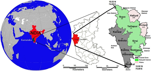
Fig. 1 Study area - Uttara Kannada district
|
|
Citation : T V Ramachandra, Bharath Setturua, Rajan K S and Subash Chandran M D, 2017. Modelling the Forest Transition in Central Western Whats, India. Spat. Inf. Res. (2017)25: 117–130, DOI 10.1007/s41324-017-0084-8.
|