

T. V. Ramachandra
(cestvr@ces.iisc.ac.in) Indian Institute of Science, Bangalore, India |
Uttam Kumar (uttam@ces.iisc.ac.in) Indian Institute of Science, Bangalore, India |


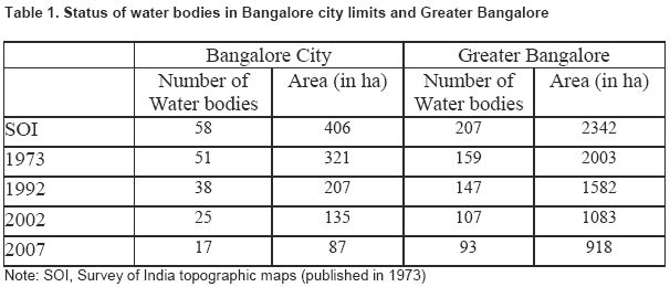
Wetlands are the most productive and biologically diverse but very fragile ecosystems. They are vulnerable to even small changes in their biotic and abiotic factors. In recent years, there has been concern over the continuous degradation of wetlands due to unplanned developmental activities. This necessitates inventorying, mapping, and monitoring of wetlands to implement sustainable management approaches. The principal objective of this work is to evolve a strategy to identify and monitor wetlands using temporal remote sensing (RS) data. Pattern classifiers were used to extract wetlands automatically from NIR bands of MODIS, Landsat MSS and Landsat TM remote sensing data. MODIS provided data for 2002 to 2007, while for 1973 and 1992 IR Bands of Landsat MSS and TM (79m and 30m spatial resolution) data were used. Principal components of IR bands of MODIS (250 m) were fused with IRS LISS-3 NIR (23.5 m). To extract wetlands, statistical unsupervised learning of IR bands for the respective temporal data was performed using Bayesian approach based on prior probability, mean and covariance. Temporal analysis of wetlands indicates a sharp decline of 58% in Greater Bangalore attributing to intense urbanization processes, evident from a 466% increase in built-up area from 1973 to 2007.