Background
Any landscape is a mosaic of heterogeneous interacting dynamic elements, i.e., manifestations of natural and anthropogenic processes. The structure of a landscape (size, shape and configuration) affects its functional aspects such as bio-geo chemical cycling and hydrologic regimes. The interactions among the landscape elements result in the flow of nutrients, minerals and energy, which contribute to the functioning of the landscape. Forest ecosystems constitute a key component of the global carbon cycle that account for over two-thirds of net primary production on land through photosynthesis converting solar energy into biomass (Roy et al. 2001; MEA 2005; Ramachandra et al. 2013). Forest ecosystems offer timber and non-timber forest products (NTFP), such as medicinal resources, fuel wood and as well provide recreational values (Kindstrand et al. 2008). They aid as biodiversity repositories (Li et al. 2009), restrain soil erosion (Nandy et al. 2011), prevent landslides given that tree roots bind soil, regulate air humidity, temperature and mitigate global warming (Cabral et al. 2010) by absorbing 30% of fossil fuel CO2 emissions (Pan et al. 2011).
The goods and services provided by forested landscapes are vital to the socioeconomic development of human populations (DeFries et al. 2004) and their survival (Ramachandra et al. 2013). At a large-scale land use, more recent land cover changes (LULC) are altering the ecosystem structure, affecting the goods and services of the ecosystem. These disturbances have resulted in fragmentation of forests with a mosaic of natural patches surrounded by other land uses (Ramachandra and Kumar 2011). A host of anthropogenic activities, such as tree logging, conversion of forest land to agriculture, intense agricultural practices, forest fire and unplanned infrastructural development have contributed to the disruption of the contiguity of forests in predominantly natural landscapes (Buskirk et al. 2000; Boogaert et al. 2004). An alteration in forest structure through fragmentation of forests has affected its functional abilities, as is evident from the decline in water yield, carbon sequestration potential and biodiversity. (Diaz et al. 2006; Ramachandra and Kumar 2011).
Fragmentation processes involve alterations in the structure and composition of native forests through the division of contiguous forest into smaller non-contiguous fragments with a sharp increase in edges (Riitters et al. 2002; Broadbent et al. 2008). This will have detrimental effects such as disruption in bio-geo chemical cycling, nutrient and water cycling, ecological processes (Fahrig 2003; Holway 2005), easier access and further land use changes (Holway 2005; Bennett and Saunders 2010; Ramachandra et al. 2012a). The edge effect may even destroy large trees within 300 m of the forest edge which are then replaced by densely spaced short-lived pioneers (Laurance 1999), resulting in the decline of forest biomass (Harper et al. 2005). The negative impact of edges include alterations in plant and animal community compositions with subsequent changes in diversity (Cagnolo et al. 2006), seed dispersion, pollination, predation, fire susceptibility, altered microclimate and increased carbon emissions (Laurance et al. 2002). Consequences of edge effects (Carolina 1995; Asner et al. 2006) also include abiotic changes such as in its micro climate (Kampichler et al. 2012) and water availability. Figure 1 explains the process of fragmentation with drivers. The earlier stages of forest fragmentation lead to changes in forest composition due to the transition of evergreen forests to a mix of semi evergreen and scrub forest patches leading to alterations in micro climate and habitat (Ramachandra et al. 2013). During the succession stage, edges will become more prominent with higher light availability and loss of soil moisture. This will directly affect seed dispersal, seed viability, species distribution and propagation of invasive species (Ramachandra and Kumar 2011). These cascading effects have the potential to disrupt seriously many basic ecological processes over large areas. The changes in forest structure will result in abrupt effects and disturbing the productivity of goods and services from the natural ecosystem. Analyses of the extent of forest fragmentation will provide insights of complex dynamic interactions, which help in adopting appropriate location specific conservation measures to mitigate disruptions in ecological processes.
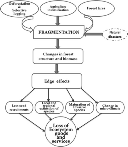
Figure 1: Theoretical frame work of fragmentation and its consequence
Quantification of forest fragmentation
Land use (LU) changes driven by anthropogenic activities alter the structure of a landscape, which adversely affect the functional aspects of an ecosystem. Land use patterns are the collective result of interactions among local geophysical indicators, such as elevation, slope and rainfall and agro-climatic indicators, demographic variation, market forces and related development policies (Munroe et al. 2004; Ameztegui et al. 2010). Numerous studies focusing on deforestation at the landscape level have explored the spatial patterns and interactions among the geophysical elements of the landscape and its dynamics (Nelson and Geoghegan 2002; Alix-Garcia et al. 2005; Echeverria et al. 2008; Ramachandra and Kumar 2011; Ramachandra et al. 2013). These changes, measured at temporal scales, help in monitoring ecosystems and aid in the implementation of location specific mitigation measures. Spatial data acquired remotely through space-borne sensors (remote sensing data) at regular intervals help in assessing the temporal changes in spatial patterns (Ramachandra et al. 2014a). Remote sensing data (RS) with geographic information systems (GIS) have made significant contributions to the examination of spatial-temporal patterns and processes of forest ecosystems (Nandy et al. 2011; Ramachandra et al. 2012a) in criteria based decision-making and selection of the optimal alternative. The availability of remote sensing data, with improvements in resolutions (spatial, spectral and temporal resolutions), enables the creation of land use and land cover maps (Chen et al. 2015), as well as that of innovative analytical techniques and helps to monitor changes in cost-effective ways (Bharath et al. 2012a). Changes in forested landscapes of the Western Ghats have been more sudden since the middle of the last century due to the impetus of industrialization policies as a consequence of globalization. Quantification of forest fragmentation in an ecologically fragile region, such as the Western Ghats will help in formulating appropriate mitigation measures towards the conservation of biodiversity.
Objectives
The objectives of this assessment of land use dynamics and forest fragmentation are to:
- understand the prevailing forest cover dynamics from 1979 to 2013 and evaluate the causal factors contributing to forest changes;
- explore the spatial-temporal patterns of forest fragmentation and quantification of the extent of fragmentation;
- evaluate the role of geophysical variables in forest cover changes and assess the effects of such variables on the patterns of forest loss at a temporal scale and
- suggest management options to mitigate forest loss and fragmentation to restore and sustain the ecosystem.
Citation : Ramachandra T.V., bharath Setturu, Subash chandran, Geospatial analysis of fragmentation in uttara kannada district,India, T V et al. Forest Ecosystems (2016) 3:10DOI 10.1186/s40663-016-0069-4
|