| |
Sayhadri Conservation Series 45 |
ENVIS Technical Report: 82, November 2014 |
 |
Water Scarcity in Varada Catchment: Need to arrest Deforestation on Priority
|
 |
Energy and Wetlands Research Group, Centre for Ecological Sciences, Indian Institute of Science, Bangalore – 560012, India.
*Corresponding author: cestvr@ces.iisc.ac.in
|
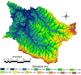
River Varada (fig. 1a, b) tributary of river Tungabhadra, is the north flowing river originating at Varadamoola of Western Ghats in Sagara taluk of Shimoga district. Origin of the Varada i.e., Varadamoola is surrounded with four hillocks. Before joining river Tungabhadra near Galaganath Village of Haveri District bordering Bellary, the river flow for about 245 km from the origin with a catchment area of 5462 sq.km. In Sagara taluk, river Varada (fig. 1a, b) flows for about 65.91km encompassing catchment area 607.97 km2 and consist about 273 lakes which are interconnected through cascaded systems in the vicinity. The terrain (fig. 2) in the catchment is highly undulating at the Ghats and flatter toward the plains. Annual precipitation in the catchment varies from 4000 mm at the ghats to 1600 mm at the plains, over years, rainfall in the catchment has declined (fig. 3), earlier to 1960’s average annual rainfall in the catchment was over 4000mm. The temperature varies from as 15.61OC low as during to 33.41OC as high as during.
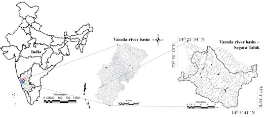
Figure 1a: Study Area
|
|
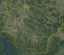
Figure 1b: Study Area overlaid on Google earth |
Figure 2: Topography |
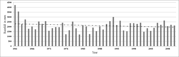
Figure 3: Rainfall variation
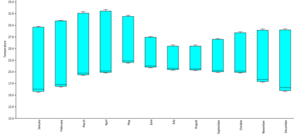
Figure 4: Temperature Variation
Similar to any other river of India, river Varada has been neglected, the Varada basin in Sagara has witnessed draw down of forest cover since 1960’s (interaction with public) which has led to the decline of the rainfall in the catchment. The river once perennial in now intermittent, many lakes are encroached due to infrastructural activities such as construction of layouts, bus stands, etc. The agricultural and horticultural activities have led to severe decline in the forests along the streams. Historically and morphologically river Varada had its own importance, the drainages connecting the river course flood during monsoon where as they go dry and contaminate post monsoon harboring mosquitoes and other agents of diseases causing social new sense. Intense use of bore wells for agriculture and horticulture activities post monsoon has led to decline in ground water level, due to which the natural springs are lost which provides water to the natural ecosystem. The ground water status is as depicted in Annexure 3, on an average ground water in the catchment is available at a depth of 5 m to about 10 m in the catchment, with yield of about 1 to 5 litres per second. Both the depth of the ground water as well as the yield can be attributed to the land use characteristics and the geological conditions. The catchment fall in the safe zone of water utilization.
|
T.V. Ramachandra
Centre for Sustainable Technologies, Centre for infrastructure, Sustainable Transportation and Urban Planning (CiSTUP), Energy & Wetlands Research Group, Centre for Ecological Sciences, Indian Institute of Science, Bangalore – 560 012, INDIA.
E-mail : cestvr@ces.iisc.ac.in
Tel: 91-080-22933099/23600985,
Fax: 91-080-23601428/23600085
Web: http://ces.iisc.ac.in/energy
Subash Chandran M.D.
Energy & Wetlands Research Group, Centre for Ecological Sciences, Indian Institute of Science, Bangalore – 560 012, INDIA.
E-mail: mds@ces.iisc.ac.in
Vinay S
Energy & Wetlands Research Group, Centre for Ecological Sciences, Indian Institute of Science, Bangalore – 560 012, INDIA.
E-mail: vinay@ces.iisc.ac.in
Bharath H. Aithal
Energy & Wetlands Research Group, Centre for Ecological Sciences, Indian Institute of Science, Bangalore – 560 012, INDIA.
E-mail: bharath@ces.iisc.ac.in
Citation: Ramachandra T.V., Subash Chandran M.D., Vinay S, 2014, Water Scarcity in Varada Catchment: Need to arrest Deforestation on Priority, Sahyadri Conservation Series 45, ENVIS Technical Report 82, CES, Indian Institute of Science, Bangalore 560012, India
|