ENVIS Technical Report: 25 |
|
|
 |
ECOLOGICAL ASSESSMENT OF LENTIC WATER BODIES OF BANGALORE T. V. Ramachandra and Malvikaa Solanki
|
 |
|
|
WATER Water is the most abundant substance, covering more than 70 percent of the earth’s surface and existing in many places and forms: mostly in the oceans and polar ice caps, but also as clouds, rain water, rivers, freshwater aquifers, and sea ice. Water is also found in the ground and in the air we breathe and is essential to all known forms of life. It makes up two thirds of our bodies. In fact, between 50 and 90 per cent of the weight of any living being is water. Great civilisations have risen where water supplies were plentiful, such as on the banks of rivers and major waterways; Mesopotamia, the so-called cradle of civilization, was situated between two major rivers. Large metropolitans like London, Paris, New York, and Tokyo owe their success in part to their easy accessibility via water and the resultant expansion of trade. Water is used for domestic purposes for cleaning, cooking bathing, and carrying away wastes, and in agriculture for irrigation, power generation, industries, navigation, recreation and many other reasons. On the planet, water is continuously moving through the cycle involving evaporation, precipitation, and runoff to the sea, thus influencing the earth’s climate. Water is in a constant state of motion as explained in the hydrological cycle shown in figure 1.1. The very act of condensation usually requires a surface, or nuclei, water may acquire impurities at the very moment of condensation. Additional impurities are added as the liquid travels through the remainder of the hydrological cycle and comes in contact with materials in the air and on or beneath the surface of the earth. Human activities contribute further to the impurities in the form of industrial and domestic wastes, agricultural chemicals and other less obvious contaminants. However, it is the water quality in the intermediate stage, which is of greatest concern, because it is the quality at this stage that affects human usage. In this context, the conservation and restoration of this precious resource is gaining importance and calls for integrated management approaches. The water resources have been grossly mismanaged to accommodate the various human needs resulting in declined water quality and considerable loss of water resources. The various impacts due to anthropogenic activities need to be assessed at regular intervals for its restoration and conservation. Recognising the importance of water resources to the planet's future, the United Nations General Assembly proclaimed the year 2003 the ‘International Year of Freshwater.’ To understand the importance of water, the implications of its mismanagement and to facilitate strategies to manage, restore and conserve this fast degrading natural resource, it becomes essential to understand its ecological status and certain processes associated with water. Hydrologic cycle - The sun powered cycle Water on the earth is in motion through the hydrological cycle. The endless circulation of water from the atmosphere to the earth and its return to the atmosphere through condensation, precipitation, evaporation and transpiration is called the hydrological cycle. The hydrological cycle depicted in Figure 1.1, illustrates the movement of water through the atmosphere to lithosphere and back into the atmosphere. As water is heated by the sun, it's surface molecules become sufficiently energised to break free of the attractive force binding them together, and then evaporate and rise as invisible vapour in the atmosphere. As water vapour rises, it cools and eventually condenses, usually on tiny particles of dust in the air (aerosols) and forms clouds. Precipitation in the form of rain, snow and hail comes from clouds. Clouds move around the world, propelled by air currents. The precipitation may be intercepted before it reaches the ground by tress and vegetation on leaves and branches, buildings, etc. which is subject to constant evaporation and part of it trickles down into the ground. Once, the water trapped in the plants is evaporated, water in the soil and saturated zone moves upward in a plant and eventually to the atmosphere through leaves. This process is known is evapo-tranpiration. The precipitation that reaches the soil surface may be absorbed by the soil through infiltration (seepage) and percolates further down. The water that enters the soil is known as sub surface water that increases the soil moisture and flows through the soil. Once the soil is saturated, overland flow begins and is often referred as surface runoff. Runoff is the visible flow of water in streams, rivers, creeks, etc. Some of the precipitation and snow melt moves downward percolates or infiltrates through cracks, joints and pores in soil and rocks until it reaches the saturated zone, where it becomes groundwater. Subterranean water is held in cracks and pore spaces.
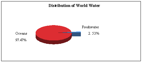
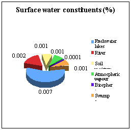
Depending on the geology, the groundwater can flow to support streams. Some groundwater aquifers are very old and may have been there for thousands of years. During the monsoons, overland flow contributes to the streams while during the non-monsoon season, the stream flow is contributed by the sub-surface flow (i.e. water stored in the vadose or sub-surface zone) and the base flow (groundwater). Water leaves the atmosphere and falls on earth as precipitation where it enters surface waters or percolates into groundwater zone via sub-surface vadose zone and eventually gets back to the atmosphere by transpiration and evaporation or as base flow in streams. Various factors influence the distribution of water on earth, leading to issues of water shortages and distribution for human consumption. Distribution of water on earth Although the earth has enormous amount of water, it is not evenly distributed on the earth. As much as two-thirds of the earth is surrounded by water. Of the total water found on earth, 97.47 percent is deposited in the oceans, seas, lakes and rivers, the most important freshwater resources, account for a measly 2.53 percent (figure 1.2). The amount of fresh-water on earth is very small compared to seawater (oceans), of which 69.6% is locked away in continental ice, 30.1% in underground aquifers, and 0.26% in rivers and lakes. Lakes in particular occupy less than 0.007% of the world’s freshwater.
Of whatever little freshwater is available on earth, most of them are tied up in difficult to use forms such as glaciers and deep groundwater. Wetlands are estimated to occupy nearly 6.4% of the earth’s surface, 30% of which is made of bogs, 26% fens, 20% swamps, about 15% flood plains, etc. (IUCN, 19902). The distribution of the world water resources compiled from various sources is listed in Table 1.1 (Ramachandra .T.V, 20021). Table 1.1: Distribution of world’s water resources
Water resources in India India by virtue of its geographical position and varied terrain and climatic zones, is blessed with many rivers, which supports a rich diversity of inland and coastal waterbodies. The annual precipitation including snowfall, which is the main source of water in the country is estimated to be of the order of 4000 cu.km. For the purpose of monitoring rainfall, the country has been divided into 35 meteorological sub-divisions. The resources potential of the country, which occurs, as natural run-off in the rivers is about 1869 cu.km as per the basin wise latest estimates of Central Water Commission, considering both surface and groundwater as one system. Ganga-Brahmaputra-Meghna system is the major contributor to the total water resources potential of the country. Its share is about 60 percent in the total water resources potential of the various rivers (National Informatics Centre 3 ). India’s geographical area of about 329 m.ha is crisscrossed by a large number of small and big rivers (National Informatics Centre 3) and mountains. There are 12 major rivers, whose total catchment area is 252 million hectare (m.ha). Of these major rivers, the Ganga - Brahmaputra - Meghana system is the biggest with a catchment area of about 110 m.ha, which is more than 43 percent of the catchment area of all the major rivers in the country. The other major rivers with catchment area more than 10 m.ha are Indus (32.1 m.ha.), Godavari (31.3 m.ha.), Krishna, (25.9 m.ha.) and Mahanadi (14.2 m.ha). The catchment area of medium rivers is about 25 m.ha and Subernarekha with 1.9 m.ha catchment area is the largest river among the medium rivers in the country (National Informatics Centre 3). Inland Water resources of the country are further classified as rivers and canals, reservoirs, tanks and ponds, beels, oxbow lakes, derelict water and brackish water. Other than rivers and canals, total waterbodies cover all area of about 7 m.ha. Most of the area under tanks and ponds lies in the southern part of the States of Andhra Pradesh, Karnataka and Tamil Nadu. These states along with West Bengal, Rajasthan and Uttar Pradesh, account for 62 percent of total area under tanks and ponds in the country. As far as reservoirs are concerned, major states like Andhra Pradesh, Gujarat, Karnataka, Madhya Pradesh, Maharashtra, Orissa, Rajasthan and Uttar Pradesh account for larger portion of area under reservoirs. More than 77 percent of area under beels, oxbow lakes and derelict water lies in the states of Orissa, Uttar Pradesh and Assam. Orissa ranks first as regards the total area of brackish water and is followed by Gujarat, Kerala and West Bengal. The total area of inland water resources is, thus, unevenly distributed over the country with five states, namely, Orissa, Andhra Pradesh, Gujarat, Karnataka and West Bengal accounting for more than half of the country's inland waterbodies. A survey conducted by the Ministry of Environment and Forests (MoEF) in 1990 showed that wetlands occupied an estimated 4.1 million hectares of which 1.5 million hectares were natural and 2.6 million hectares man-made (excluding paddy fields, rivers and streams) and mangroves occupying an estimated 0.45 million hectares. About 80% of the mangroves were distributed in the Sunderbans of West Bengal and Andaman and Nicobar Islands, with the rest in the coastal states of Orissa, Andhra Pradesh, Tamil Nadu, Karnataka, Kerala, Goa, Maharashtra and Gujarat. A preliminary inventory by the Department of Science and Technology, recorded a total of 1193 wetlands, covering an area of about 3,904,543 ha, of which 572 were natural (Scott and Pole, 1989 4). Threats to water resources Most often human interactions with water involve fresh streams, rivers, marshes, lakes, and shallow groundwaters. As is true of all organisms, our very existence depends on this water; we need an abundance of fresh water to live.Globally, there are increasing problems related to the availability of freshwater. Less than 1% of all water on Earth is available for human consumption (figure 1.2). This precious resource is not only being overexploited but also is seriously degraded due to anthropogenic activities involving indiscriminate disposal of pollutants in waterbodies, which has rendered it unfit for sustenance of life. According to the United Nations Environment Program (UNEP), close to one quarter of the world’s population may soon suffer from chronic water shortages. The most significant threats to water resources are from point sources (sewage, industrial effluents, etc.) and from non-point sources (agriculture, urban, etc.) Apart from these, dumping of solid wastes, chemical spills, thermal pollution, acid precipitation, mine drainage, etc. also contribute. Pollution of any form first affects the chemical quality of the water and then systematically destroys the community, disrupting the delicate food web in these aquatic ecosystems. Understanding the implications of each of these threats requires characterisation of aquatic ecosystems involving detailed understanding of the ecology. |


|