ENVIS Technical Report: 25 |
|
|
 |
ECOLOGICAL ASSESSMENT OF LENTIC WATER BODIES OF BANGALORE T. V. Ramachandra and Malvikaa Solanki
|
 |
|
|
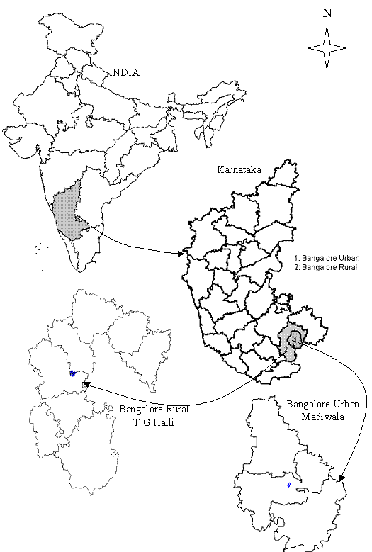
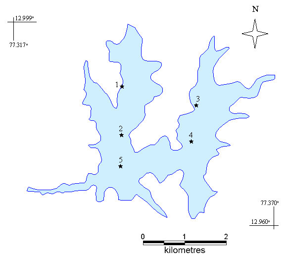
STUDY AREA Chamarajasagar reservoir The reservoir was constructed in 1933, which at the time was 60 feet deep and later in 1958 was raised to 74 feet, which is also the current depth (table 3.1). Chamarajasagar reservoir is constructed at the confluence of Arkavathi and Kumudavathi rivers, both tributaries of river Cauvery, at Tippagondana halli near Magadi taluk, Bangalore south – 56º21'20" (Figure 3.1, 3.2). Arkavati, which originates at Nandi hills, flows into the Hesarghatta tank in Bangalore city whose surplus overflows cutting through the Bangalore Tumkur National Highway 4 as Arkavathi and drains into the reservoir. The other inlet, Kumudavati, originates in Shivaganga near Dabaspete and after joining Arkavathi at Tippagondanahalli it continues to flow as Arkavati. Both these tributaries of river Cauvery meet at the Sangama at a place popularly known as Meke daatu near Kanakapura. Both Kumudavati and Arkavati are dry most of the year and the flow is obvious only during the monsoons. The reservoir’s surplus in turn is let into a canal, which connects to the Manchinabale reservoir near Ramanagaram. This reservoir in addition to the overflow form Chamarajasagar reservoir receives its main inflow from a lake Chik tore. Table 3.1: Chamarajasagar reservoir factfile
The recent filling of the Chamarajasagar reservoir is due to the independent catchments of the valley rather than any surplus flows from the interconnected waterbodies. The reservoir receives most of its inflow during the post monsoons, which is in September and October. Large portion of the catchment area is dry open land, rocky regions, and small-forested pockets or monsoon dependent agricultural land. The forest department has recently been planting trees, which cover a considerable area around the reservoir. With the onset of the monsoons at the end of July there is sufficient land cover which during September - October, when the monsoon results in peak inflows combats the erosion form the dry barren lands reducing turbidity and runoff. The inflowing turbidity is further diluted once it enters the reservoir. There have not been problems related to siltation in the reservoir since its inception. Further the water is impounded with no continuing inflows, which cease after the monsoons recede, which again explains the consistent water quality of the reservoir.
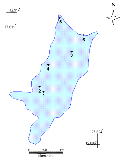
Although there is no immediate threat to the water quality of the reservoir there is a growing concern over the rapidly mushrooming industries in the catchment areas more importantly along the Bangalore – Tumkur National highway 4,where it is feared that the effluent flow as a consequence of rapid industrialisation in this belt could pollute the valley leading to degradation of the water quality in the downstream. In addition to this there has been an increased activity related to stone quarries leading to the degradation of the catchment. Along the Kumudavati there has been major quarry establishments and a few in the catchments of Arkavati and around the reservoir. Encouraging such activities not only disrupts the ecological balance in the watershed but also poses a serious threat to the very structure of the reservoir. Madiwala Lake The Madiwala Lake is located in Bangalore south between Bannerghatta road and Hosur road covering an extent of 272 acres (110.07 ha) (table 3.2). The water-spread area is about 200 acres (80.93 ha) and the wetland area is about 72 acres (29.13 ha). Earlier the lake formed an important landmark of the city and had a wide catchment area, which filled to the maximum water level every monsoon. (Figure 3.3). Madiwala Lake receives water from two lakes Hulimavu and Jaraganahallikere on the upstream. With a large catchment area spread into the Hulimavu valley and Jaraganahallikere, Madiwala Lake has the capacity to fill up to the maximum during a good monsoon season and helps with the important wetland functions of recharging of the sub-soil ground water table around the area. Lately the holding capacity of the lake is considerably reduced due to the blockage of the inflowing channels, illegal encroachments in the catchment area, etc. Table 3.2: Madiwala lake factfile
Sewage water has become the only major source of inflow into the lake, which has led to a drastic change in the water quality. The lake has a STP (sewage treatment plant) of 4 million litres per day (mld) capacity (total amount of sewage produced in the area is around 12 mld) on the south west end, which treats a portion of the inflowing sewage and the remaining sewage is let into the sewage diversion channels untreated, which is on the eastern side of the lake. There is a storm water drain towards the north side near the bund region. The lake is fenced with barbed wires and on the western side of the lake is a walk path, which was developed during the restoration of the lake. During this study the fencing was incomplete on the northern side, which paves way for people to dump garbage and filth into the lake. The adjoining slum dwellers have converted this side of the shore into a major defecating zone. The lake also allows for fishing and the fisheries department undertakes this. The Karnataka State, Forest department and the Lake Development Authority, under the Indo- Norwegian Environment Programme had undertaken restoration of the lake in the year 2000 and today Madiwala Lake is a popular recreational spot, with boating facilities and bird watching. Construction activities in the catchment area have increased dramatically over the last few decades due the pressure of urbanisation and pressure on land. The area has been converted into huge residential and commercial properties without providing for the basic amenities and infrastructure. With this, Madiwala Lake perhaps became the most convenient site to dump the construction debris and sewage. During the monsoons, the excess storm waters choke the drains and the weir at the outlet is blocked leading to the mixing of the sewage with the storm water, which eventually finds its way into the lake. The depth of the lake has also decreased due to the increased sedimentation, thus reducing the capacity of the lake. As a result of the increased pollutants there is proliferation of rooted aquatic plants and water hyacinth. The weed growth prevents surface aeration and penetration of sunlight, which in turn affects the dissolved oxygen content in the lake and consequently influencing the biodiversity of the lakes’ flora and fauna. The proliferating growth of weeds also contributes to the spread of mosquitoes and water borne diseases.
|
|